Issac-Prep/Obs/Haiti/DR/Cuba/Bahamas/Keys/Florida Pen/PH
Moderator: S2k Moderators
Forum rules

The posts in this forum are NOT official forecasts and should not be used as such. They are just the opinion of the poster and may or may not be backed by sound meteorological data. They are NOT endorsed by any professional institution or STORM2K. For official information, please refer to products from the National Hurricane Center and National Weather Service.
-
summersquall

- Tropical Storm

- Posts: 230
- Joined: Wed Jun 16, 2010 11:23 am
- Location: Jensen Beach FL 27°N 80°W (roughly)
Wow artist. Thanks for posting those pictures. Nothing nearly as dramatic for me here in Jensen, a stone's throw from St. Lucie inlet.
0 likes
My posts should NEVER, EVER, EVER be construed as an official forecast as I know virtually nada respecting the finer points of meteorology. Consequently, my posts are obviously NOT endorsed by any professional institution or the good folks at storm2k.org. For official information please refer to the weather gurus at the NHC and NWS.
Re: Issac-Prep/Obs/Haiti/DR/Cuba/Bahamas/Keys/Florida Pen/PH
Gust-driven heavy rain bursts here.
0 likes

Re: Issac-Prep/Obs/Haiti/DR/Cuba/Bahamas/Keys/Florida Pen/PH
 The Acreage

all from WPTV
We actually have a break in the clouds!

0 likes
-
VeniceInlet

- Tropical Depression

- Posts: 92
- Joined: Sun Jun 11, 2006 10:12 pm
- Location: Nokomis, FL
Re: Issac-Prep/Obs/Haiti/DR/Cuba/Bahamas/Keys/Florida Pen/PH
After an afternoon of relative calm, now getting fairly regular bands of quite high gusty winds, with spitting rain.
0 likes

Re: Issac-Prep/Obs/Haiti/DR/Cuba/Bahamas/Keys/Florida Pen/PH
wow, artist, those pictures are incredible.
Thanks for posting them.
It will take a good while for you guys to dry out.
Glad you are ok though.
Thanks for posting them.
It will take a good while for you guys to dry out.
Glad you are ok though.
0 likes
Too many hurricanes to remember


-
MiamiensisWx
The power grid truly laid bare its vulnerabilities here in East Boca Raton. I observed probably hundreds of transformers imploding last night, including sparks, yet peak sustained winds here never reached 40 mph (35 kt)--meaning the grid failed during a protracted period of 30-mph (25-kt) winds. Even given the long period of winds, the grid should have been able to survive unscathed--in other areas of the world, like Bermuda, grids often remain operational even during Category 1 winds--yet instead 100,000+ residents in Boca lost power last night. In my view, the much-lauded and -touted revitalization of the grid by FPL was yet the latest farce in the history of the degrading power grid in South FL. I cannot imagine what a major hurricane with Category 2+ winds would do.
As an aside, Isaac encapsulated why all storms should be taken seriously. While sustained winds in most of SE FL never reached tropical-storm intensity, the long, nearly 24-hour duration of near-TS winds, plus extremely heavy rainfall of up to 15 inches, served to knock down many small, recently planted shrubs and trees. I even saw some locations where images indicated that larger trees in West Palm Beach were prostrated. Even though pruning, the relatively light winds, and the previous trimmings by Hurricane Wilma (2005) helped reduce flying debris, the saturated soils allowed the winds to topple exposed plants. Plus, all of SE FL had localized to widespread flooding and even a tornado in Lake Worth. So even a non-TS, under the right (wrong!) conditions, can create a very messy and dangerous situation.
Here in Palm Beach County, so many campuses are flooded that schools have been closed for yet another day. Such a decision says much about the effects of Isaac, the epitome of the truth that even weak systems are to be monitored.
0 likes
-
AdamFirst

- S2K Supporter

- Posts: 2490
- Age: 36
- Joined: Thu Aug 14, 2008 10:54 am
- Location: Port Saint Lucie, FL
Re: Issac-Prep/Obs/Haiti/DR/Cuba/Bahamas/Keys/Florida Pen/PH


Taken from my cellphone yesterday
This was the road outside my house, several cars were stranded
My van almost stalled
0 likes
Dolphins Marlins Canes Golden Panthers HEAT
Andrew 1992 - Irene 1999 - Frances 2004 - Jeanne 2004 - Wilma 2005 - Fay 2008 - Isaac 2012 - Matthew 2016 - Irma 2017 - Dorian 2019 - Ian 2022 - Nicole 2022 - Milton 2024
Andrew 1992 - Irene 1999 - Frances 2004 - Jeanne 2004 - Wilma 2005 - Fay 2008 - Isaac 2012 - Matthew 2016 - Irma 2017 - Dorian 2019 - Ian 2022 - Nicole 2022 - Milton 2024
Tammster, incredible pictures.
How are things there this morning?
DId you hear about the road that collapsed out here at 40th and Coconut? There is a literal waterfall running out of the canal to the surrounding areas. Hall, which we live off of is under water this morning. It was flooded yesterday but rising much more today.
How are things there this morning?
DId you hear about the road that collapsed out here at 40th and Coconut? There is a literal waterfall running out of the canal to the surrounding areas. Hall, which we live off of is under water this morning. It was flooded yesterday but rising much more today.
0 likes
-
Portastorm

- Storm2k Moderator

- Posts: 9954
- Age: 63
- Joined: Fri Jul 11, 2003 9:16 am
- Location: Round Rock, TX
- Contact:
Re: Issac-Prep/Obs/Haiti/DR/Cuba/Bahamas/Keys/Florida Pen/PH
Hey Floridians ... thanks for the great photos. Somehow it seems like the national news missed this story. You'd think Florida escaped unharmed from Isaac. Clearly that is not the case. Stay safe over there!
0 likes
Any forecasts under my name are to be taken with a grain of salt. Get your best forecasts from the National Weather Service and National Hurricane Center.
-
AdamFirst
- S2K Supporter
- Posts: 2490
- Age: 36
- Joined: Thu Aug 14, 2008 10:54 am
- Location: Port Saint Lucie, FL
Re:
artist wrote:Wow Adam, how is your area this morning? Any better?
It's drained relatively quickly, but any more deluges (like they're saying today) could cause major problems
standing water is already everywhere
0 likes
Dolphins Marlins Canes Golden Panthers HEAT
Andrew 1992 - Irene 1999 - Frances 2004 - Jeanne 2004 - Wilma 2005 - Fay 2008 - Isaac 2012 - Matthew 2016 - Irma 2017 - Dorian 2019 - Ian 2022 - Nicole 2022 - Milton 2024
Andrew 1992 - Irene 1999 - Frances 2004 - Jeanne 2004 - Wilma 2005 - Fay 2008 - Isaac 2012 - Matthew 2016 - Irma 2017 - Dorian 2019 - Ian 2022 - Nicole 2022 - Milton 2024
Re: Re:
AdamFirst wrote:artist wrote:Wow Adam, how is your area this morning? Any better?
It's drained relatively quickly, but any more deluges (like they're saying today) could cause major problems
standing water is already everywhere
glad it is draining there.
Our problem here is it is rising still.
0 likes
Re: Issac-Prep/Obs/Haiti/DR/Cuba/Bahamas/Keys/Florida Pen/PH
Not as strong as yesterday but still windy over here which shows the size of Isaac's wind coverage.
0 likes
Re:
artist wrote:Tammster, incredible pictures.
How are things there this morning?
DId you hear about the road that collapsed out here at 40th and Coconut? There is a literal waterfall running out of the canal to the surrounding areas. Hall, which we live off of is under water this morning. It was flooded yesterday but rising much more today.
Out west I don't think the water level went down even one inch. It was quite a challenge out there to find enough people who have trucks to help everyone down their street.
Here are more pictures. Note that there should be NO water in any of those pictures. It was all rainfall.
These were taken on my street this morning... note it stopped raining (except light rain) at about 5pm yesterday.


This is the updated rainfall totals. In 72 hours we had somewhere between 15-20 inches.

0 likes
-
Janie2006

- Category 5

- Posts: 1329
- Joined: Mon Sep 18, 2006 3:28 pm
- Location: coastal Ms aka home of the hurricanes
COASTAL HAZARD MESSAGE
NATIONAL WEATHER SERVICE TALLAHASSEE FL
524 PM EDT TUE AUG 28 2012
...COASTAL FLOOD WARNING IS NOW IN EFFECT UNTIL NOON EDT /11 AM
CDT/ WEDNESDAY FOR COASTAL AREAS OF THE FLORIDA PANHANDLE
EASTWARD THROUGH FRANKLIN COUNTY IN THE FLORIDA BIG BEND...
...COASTAL FLOOD ADVISORY IS NOW IN EFFECT UNTIL NOON EDT FOR
COASTAL AREAS OF THE FLORIDA BIG BEND FROM WAKULLA COUNTY
SOUTHEASTWARD THROUGH DIXIE COUNTY...
...HIGH SURF WARNING IN EFFECT UNTIL 8 PM EDT /7 PM CDT/
WEDNESDAY EVENING FOR THE BEACHES OF SOUTH WALTON...COASTAL BAY...
COASTAL GULF AND COASTAL FRANKLIN COUNTIES IN THE FLORIDA
PANHANDLE...
FLZ108-112-114-291600-
/O.EXT.KTAE.CF.W.0002.000000T0000Z-120829T1600Z/
/O.CON.KTAE.SU.W.0001.000000T0000Z-120830T0000Z/
SOUTH WALTON-COASTAL BAY-COASTAL GULF-
524 PM EDT TUE AUG 28 2012 /424 PM CDT TUE AUG 28 2012/
...COASTAL FLOOD WARNING NOW IN EFFECT UNTIL NOON EDT /11 AM CDT/
WEDNESDAY...
...HIGH SURF WARNING REMAINS IN EFFECT UNTIL 8 PM EDT /7 PM CDT/
WEDNESDAY...
* COASTAL FLOODING...STORM SURGE VALUES OF 2 TO 4 FEET ABOVE
NORMAL TIDE LEVEL WILL CONTINUE TO BE EXPERIENCED ACROSS THE
FLORIDA PANHANDLE DUE TO THE STRONG WINDS AROUND TROPICAL
STORM ISAAC.
* WAVES AND SURF...SURF HEIGHTS OF 8 TO 10 FEET ARE EXPECTED IN
GULF COUNTY...AND 9 TO 14 FEET WITH ISOLATED HIGHER BREAKERS
NEAR 16 FEET ALONG THE BEACHES OF WALTON AND BAY COUNTY.
* TIMING...STORM SURGE CONTINUES TO IMPACT THE FLORIDA PANHANDLE
COAST AND COULD REMAIN ELEVATED THROUGH THE NEXT HIGH TIDE CYCLE
ON WEDNESDAY. THIS NEXT HIGH TIDE IN THE FLORIDA PANHANDLE
OCCURS BETWEEN 8 AM CDT AND 11 AM CDT ON WEDNESDAY.
* IMPACTS...MINOR TO MODERATE COASTAL INUNDATION IS EXPECTED
PRIMARILY IMPACTING BEACH ACCESS ROADS AND LOW LYING AREAS
ALONG THE COAST. THE LARGE AND BATTERING SURF WILL CAUSE
MODERATE TO MAJOR BEACH EROSION. THE RIP CURRENT RISK WILL BE
EXTREME.
0 likes
-
MiamiensisWx
Re: Issac-Prep/Obs/Haiti/DR/Cuba/Bahamas/Keys/Florida Pen/PH
FLOOD WARNING
NATIONAL WEATHER SERVICE MIAMI FL
549 PM EDT TUE AUG 28 2012
FLC011-099-300030-
/O.EXT.KMFL.FA.W.0002.000000T0000Z-120830T0030Z/
/00000.0.ER.000000T0000Z.000000T0000Z.000000T0000Z.OO/
BROWARD FL-PALM BEACH FL-
549 PM EDT TUE AUG 28 2012
THE NATIONAL WEATHER SERVICE IN MIAMI HAS EXTENDED THE
* FLOOD WARNING FOR...
EASTERN BROWARD COUNTY IN SOUTHEAST FLORIDA...
THIS INCLUDES THE CITIES OF...TAMARAC...SUNRISE...POMPANO BEACH...
PLANTATION...PEMBROKE PINES...MARGATE...HOLLYWOOD...FORT
LAUDERDALE...DEERFIELD BEACH...DAVIE...CORAL SPRINGS...
EASTERN PALM BEACH COUNTY IN SOUTHEAST FLORIDA...
THIS INCLUDES THE CITIES OF...WEST PALM BEACH...RIVIERA BEACH...
LAKE WORTH...JUPITER...DELRAY BEACH...BOYNTON BEACH...BOCA RATON...
* UNTIL 830 PM EDT WEDNESDAY
* AT 543 PM EDT...TRAINED WEATHER SPOTTERS AND MEDIA REPORTS ACROSS
PORTIONS OF PALM BEACH COUNTY AND BROWARD COUNTY CONTINUE TO
INDICATE EXTENSIVE FLOODING ACROSS EASTERN PALM BEACH AND BROWARD
COUNTIES. THE NATURE AND EXTENT OF THE FLOODING IS SUCH THAT IT WILL
CONTINUE OVERNIGHT AND INTO AT LEAST WEDNESDAY EVENING AS IT WILL
NOT RECEDE QUICKLY. THEREFORE...THE FLOOD WARNING HAS BEEN EXTENDED
THROUGH WEDNESDAY EVENING.
A FLOOD WARNING MEANS THAT FLOODING IS IMMINENT OR HAS BEEN REPORTED.
PRECAUTIONARY/PREPAREDNESS ACTIONS...
BE ESPECIALLY CAUTIOUS AT NIGHT WHEN IT IS HARDER TO RECOGNIZE THE
DANGERS OF FLOODING. THE WATER MAY OBSCURE DEEP CANALS OR PONDS.
A FLOOD WARNING MEANS THAT FLOODING IS IMMINENT OR OCCURRING. IF YOU
ARE IN THE WARNING AREA MOVE TO A SAFER LOCATION IMMEDIATELY.
&&
LAT...LON 2600 8012 2600 8035 2696 8055 2697 8038
2696 8017 2697 8014 2697 8008 2681 8003
2681 8004 2680 8005 2663 8003 2660 8004
2659 8003
$$
60
http://forecast.weather.gov/wwamap/wwatxtget.php?cwa=mfl&wwa=flood%20warning
.DISCUSSION...
SHOWERS AND THUNDERSTORMS WERE BEGINNING TO DEVELOP ACROSS THE
REGION THIS AFTERNOON. STORM MOTION IS TO THE NORTH AROUND 10
KNOTS. SO WITH LINES OF SHOWERS AND STORMS DEVELOPING...TRAINING
OF STORMS IS POSSIBLE. THESE STORMS WERE BEGINNING TO DEVELOP OVER
THE AREAS THAT WERE FLOODED BY HEAVY RAIN THIS WEEKEND...ACROSS
BROWARD AND PALM BEACH COUNTIES. THIS IS A MAJOR CONCERN GOING
THROUGH THE REST OF THIS AFTERNOON AND INTO THE EVENING HOURS...AS
ANY RAINFALL WILL AGGRAVATE THE FLOODING PROBLEMS IN THESE
REGIONS. FLASH FLOOD WARNINGS MAY BE NEEDED FOR PALM BEACH AND
BROWARD COUNTIES ONCE AGAIN IF THESE LINES OF STORMS PERSIST.
AREAL FLOOD WARNINGS AND FLOOD WATCHES REMAIN FOR PALM BEACH AND
BROWARD COUNTIES THROUGH THIS EVENING.
JUST TO SHOW HOW MUCH RAIN HAS FALLEN THIS MONTH ACROSS PALM BEACH
COUNTY...PALM BEACH INTERNATIONAL AIRPORT SET A 2-DAY RAINFALL
RECORD FOR THE MONTH OF AUGUST...RECORDING 9.03 INCHES OF RAIN ON
THE 26TH AND 27TH. IN ADDITION...PALM BEACH INTERNATIONAL AIRPORT
HAS ALREADY SET A RECORD FOR THE MOST RAINFALL RECEIVED IN THE
MONTH OF AUGUST. SO FAR THIS MONTH (THROUGH THE 27TH)...THE
AIRPORT HAS RECEIVED 22.28 INCHES OF RAIN AND THE OLD RECORD FOR
THE MONTH OF AUGUST WAS 20.12 INCHES OF RAIN BACK IN 1995. EVEN
MORE RAIN THAN THIS HAS FALLEN TO THE WEST OF THE AIRPORT...WHERE
THE FLOODING CONDITIONS ARE ONGOING.
LOCALLY HEAVY RAINFALL WILL BE POSSIBLE ACROSS MOST OF THE REST OF
SOUTH FLORIDA THIS AFTERNOON...DUE TO THE DEEP TROPICAL MOISTURE
AND SOUTHERLY FLOW. A FEW STRONG TO SEVERE STORMS ARE POSSIBLE
AS WELL...MAINLY DUE TO WATER LOADING WITH WET MICRO/MACROBURSTS.
CAPE VALUES ARE ALREADY IN EXCESS OF 4000 J/KG ACROSS THE REGION
WITH TEMPERATURES IN THE UPPER 80S TO LOWER 90S AND DEWPOINTS IN
THE UPPER 70S.
http://www.srh.noaa.gov/productview.php?pil=AFDMFL
0 likes
-
MiamiensisWx
Re: Issac-Prep/Obs/Haiti/DR/Cuba/Bahamas/Keys/Florida Pen/PH
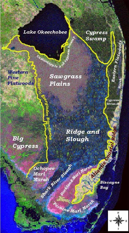
What is most arresting is that the images and rainfall data show that the worst flooding occurred in the low-lying communities on the edge of the Everglades...i.e., Loxahatchee, Royal Palm Beach, Wellington, areas west of Stuart, Port St. Lucie, and Fort Pierce, etc. Ditto for the Everglades itself. Before South Florida succumbed to development, these areas prior to the 1950s were largely undrained, as water levels flowed freely from Lake Okeechobee southward. Canal construction after World War II completely altered the area, allowing development to spread, but many new residents were unaware that they were living in historic flood zones.
Here is an image showing just how vast the Everglades was prior to drainage in the early 1900s...few people in Fort Lauderdale, Miami, and West Palm Beach realize that most of their cities lie in historic wetlands and drainage patterns:
Wikipedia map of Everglades
Historical water flow (courtesy of this link)
For a historical perspective on the hydrology of South Florida, I would advise residents to recall that in 1947, two hurricanes and a tropical storm struck South FL in just a few weeks, producing more than 100 inches of rain...with an October hurricane accounting for most of the deluge. Just as after Isaac, low-lying areas became saturated, and high coastal tides prevented the water from draining to the Atlantic Ocean...so stagnant floodwaters up to five feet deep covered 5,000,000+ acres of the southern half of FL, persisting for two months.
At the time, even the highest coastal land in South FL...such as the ridge on which Federal Highway (U.S. Route 1) is built...was submerged from Miami to Boca Raton, according to local newspapers, which also reported that residents could ride in a boat from Miami to Everglades City or Naples, for such was the extent of the sheet of water in the Everglades. Here is some valuable information on the subject from Wikipedia...I actually did extensive research on the subject and wrote the entire article:
Article on the October 1947 hurricane
Note how the struggle to balance environmental conservation with flood protection, to balance the need for flood control with the knowledge of unintended consequences--plus the way in which disasters divide communities--is very much a part of the contemporary scene in South FL.
Even Isaac, fortunately, did not produce enough rain to flood the highest elevations...but history shows that such floods can and will happen again. Yet population growth has made the potential for destruction much greater than in the 1940s. (Ironically, the Great Flood of 1947 was the event that spurred Congress to form the South Florida Water Management District, the very agency that would build canals and levees to drain the Everglades for development...something that today is widely regarded as an example of poor foresight, just as the Misssissippi River Gulf Outlet was in LA.)
Here is an image showing just how vast the Everglades was prior to drainage in the early 1900s...few people in Fort Lauderdale, Miami, and West Palm Beach realize that most of their cities lie in historic wetlands and drainage patterns:
Wikipedia map of Everglades
Historical water flow (courtesy of this link)
For a historical perspective on the hydrology of South Florida, I would advise residents to recall that in 1947, two hurricanes and a tropical storm struck South FL in just a few weeks, producing more than 100 inches of rain...with an October hurricane accounting for most of the deluge. Just as after Isaac, low-lying areas became saturated, and high coastal tides prevented the water from draining to the Atlantic Ocean...so stagnant floodwaters up to five feet deep covered 5,000,000+ acres of the southern half of FL, persisting for two months.
At the time, even the highest coastal land in South FL...such as the ridge on which Federal Highway (U.S. Route 1) is built...was submerged from Miami to Boca Raton, according to local newspapers, which also reported that residents could ride in a boat from Miami to Everglades City or Naples, for such was the extent of the sheet of water in the Everglades. Here is some valuable information on the subject from Wikipedia...I actually did extensive research on the subject and wrote the entire article:
The 1947 Cape Sable hurricane, sometimes known informally as Hurricane King, was a weak tropical cyclone that became a hurricane and caused catastrophic flooding in South Florida and the Everglades in mid-October 1947. The eighth tropical storm and fourth hurricane of the 1947 Atlantic hurricane season, it first developed on October 9 in the southern Caribbean Sea and hence moved north by west until a few days later it struck western Cuba. The cyclone then turned sharply to the northeast, accelerated, and strengthened to a hurricane, within 30 hours crossing the southern Florida peninsula. Across South Florida, the storm produced widespread rainfall up to 15 inches (380 mm) and severe flooding, among the worst ever recorded in the area, that led to efforts by the United States Congress to improve drainage in the region.
...
Region-wide, the hurricane produced significant rainfall totals of 5 inches (130 mm) to 12 in (300 mm)—and, in the interior, locally as high as 15 in (380 mm)[7]—causing severe flooding.[4] The highest measured rainfall total in 24 hours in South Florida was 14.2 in (360 mm) in northeastern Broward County.[8] At a weather observation site in Hialeah, 1.32 in (34 mm) of rain fell in as little as 10 minutes.[3] In all, as much as 6 in (150 mm) fell in just 1¼ hour in the city;[4][3] due to saturated ground preceding the arrival of the storm, much of the area flooded easily, leaving parts of the city submerged under 6 feet (1.8 m) of water.[3][4] Similarly, “waist deep” depths were reported in nearby Miami Springs, Opa-locka, rural western sections of Pompano Beach, and many other cities of the Miami metropolitan area.[3][9] In Boca Raton, homes in the historic Old Floresta district that housed Army Air Field soldiers were flooded in up to 8 in (200 mm) of water.[10] In the wake of the flooding in his city, Hialeah City Mayor Henry Milander blocked access from surrounding cities.[3] In the Miami area, the Little River and the Seybold Canal overflowed,[3] as did the New River once again in Fort Lauderdale, which had previously done so during the September hurricane.[11] During the storm, up to 11 in (280 mm) of rain in three hours were reported to have fallen on the city of Fort Lauderdale,[11] and sections of Broward County were under 8 ft (2.4 m) of water.[12] On the Tamiami Trail, floodwaters extended all the way across the state from the Miami area to as far west as Everglades City in Collier County.[4] Due to the floods, septic tanks overflowed, leaving canal banks and patches of ground isolated by floodwaters;[11] reportedly, U.S. Route 1, locally called Federal Highway and built largely upon the Atlantic coastal ridge—the highest elevation in South Florida—was flooded out between Miami and Fort Lauderdale.[4] Having been isolated by the floods, deer, rattlesnakes, and other wildlife, along with horses and cattle, sought shelter upon the remaining exposed ground,[11] particularly levee banks.[12]
The flooding that resulted from the storm and the earlier September hurricane was among the worst ever recorded in South Florida and became known as the “Flood of 1947” or, as the South Florida Sun-Sentinel newspaper in 1990 called it, the “the Great South Florida Flood.”[12] The rains from the storms followed an abnormally wet rainy season in the spring of 1947 that raised the water table to dangerous levels and by July forced several emergency meetings by the Everglades Drainage District (EDD) to address widespread flooding.[9][11] Despite the measures, which resulted in the opening of floodgates to relieve flooded farmlands by diverting water through back-pumping to Lake Okeechobee, lack of funding hampered efforts by EDD Chief Engineer Lamar Johnson to address the situation.[12] After the October hurricane struck Florida, eleven counties extending south from Osceola County, Florida, were at least 50% flooded[9][1]—roughly 90% of the land mass from Orlando to the Florida Keys.[12] South of Lake Okeechobee, a sheet of standing water covering 20 mi (32 km) to 40 mi (64 km) across and ranging from 6 in (0.15 m) to 10 ft (3.0 m) deep inundated much of the region, including the Everglades.[9] In the region, 5,000,000 acres (2,000,000 ha) of land were flooded as abnormally high coastal tides prevented water from being released through canals to the Atlantic Ocean.[12] The flooding divided many communities: near Fort Lauderdale, a temporary dam that had been erected by the U.S. Army Corps of Engineers to protect Davie—a town in which 90% of the homes by the end of October were at least partially submerged[9]—lowered waters in some areas but merely diverted them to others, flooding a neighborhood and leading to angry complaints by residents; the situation worsened after the October hurricane produced even more rain over flooded South Florida.[12]
...
In South Florida, the flooding from the September and October hurricanes led to the creation in 1949 of what is now the South Florida Water Management District, which under a Congressional plan was entrusted with the task of preventing a recurrence of significant flooding by forming an improved flood-control system to modulate the water table and by providing suitable water levels with which to water crops, prevent saltwater intrusion, and support recreational opportunities as well as the growing South Florida communities.[11][9][12] Large pumping systems were constructed, along with numerous new levees and canals, to mitigate the risk of large-scale flooding, yet population growth since the late 1940s is believed to have reduced the extent of vacant lands needed for effective drainage, thereby increasing the risk of damage during a flood similar to that of 1947.[4] In his 1974 book Beyond the Fourth Generation, former EDD Chief Engineer Lamar Johnson voiced his concerns about large-scale development near the levees, which separate the Everglades water conservation areas from the Miami metropolitan area. Johnson wrote, “It is my opinion...that anytime that area gets a foot or more of rainfall overnight, the shades of 1947’s flood will be with them again.”[14]
Article on the October 1947 hurricane
Note how the struggle to balance environmental conservation with flood protection, to balance the need for flood control with the knowledge of unintended consequences--plus the way in which disasters divide communities--is very much a part of the contemporary scene in South FL.
Even Isaac, fortunately, did not produce enough rain to flood the highest elevations...but history shows that such floods can and will happen again. Yet population growth has made the potential for destruction much greater than in the 1940s. (Ironically, the Great Flood of 1947 was the event that spurred Congress to form the South Florida Water Management District, the very agency that would build canals and levees to drain the Everglades for development...something that today is widely regarded as an example of poor foresight, just as the Misssissippi River Gulf Outlet was in LA.)
0 likes
Who is online
Users browsing this forum: AnnularCane, Cleveland Kent Evans, ElectricStorm, Google Adsense [Bot], Ulf and 63 guests