ATL: ISAAC - Post-Tropical - Discussion
Moderator: S2k Moderators
-
Garnet 1990s
- Tropical Wave

- Posts: 2
- Joined: Thu Aug 30, 2012 10:34 am
Re: ATL: ISAAC - Tropical Storm - Discussion
Any one in Little Rock AR. My daughter is almost in Little Rock driving from Memphis. She is trying to get to Houston TX. Do you think she will beat Issac if she takes HWY 30 to Texarkana then on to Dallas and 75 South. She should be to the AR/TX border in about 3 hours....Any advise I don't want to take chances...she can head N to Ok City and then South but it would be LOTS faster to take HWY 30.
0 likes
-
gboudx

- S2K Supporter

- Posts: 4090
- Joined: Thu Sep 04, 2003 1:39 pm
- Location: Rockwall, Tx but from Harvey, La
Unfortunately I don't. I'm listening to WWLTV out of New Orleans and they have only mentioned Kentwood and Robert, La since they have talked to La authorities.
http://www.wwltv.com/news/local/Tangipa ... 94886.html
http://www.wwltv.com/news/local/Tangipa ... 94886.html
0 likes
-
WeatherGuesser
- Category 5

- Posts: 2672
- Joined: Tue Jun 29, 2010 6:46 am
Re: ATL: ISAAC - Tropical Storm - Discussion
crimi481 wrote:So - right on track towards Midwest? I don't get it
gboudx wrote:Yep, right on track as its been. I know you said it would go east, southeast, whatever but it hasn't. It's done what the NHC has said.
SoupBone wrote:You think he's making it to the Midwest?
gboudx wrote:If they say it's going to the Midwest, then I'm buying that it's going to the Midwest. Besides, they've addressed the ridge and said it will move to the east allowing Isaac to round it into the Midwest. The ridge isn't parked there.
Already approaching Memphis.
Local forecasters around PAH and STL are calling for heavy rain starting tomorrow.
0 likes
-
midnight8

- Tropical Depression

- Posts: 75
- Age: 52
- Joined: Sat Aug 14, 2010 3:05 pm
- Location: Orange, Texas
Re:
gboudx wrote:The dam on Lake Tangipahoa at Percy Quinn State Park in McComb, Ms has been overtopped and is failing. Complete failure is certain. Authorities are telling people in Kentwood and Robert, La to get out now. They have 90 mins before the water reaches them. Please call anyone you know in the area to let them know if they may not be keeping up with the news. This is a very dangerous situation.
Dang!!! My grandad is in McComb for a reunion. I just called him and he says he is not close enough for that dam to affect him. I hope he is right.
0 likes
KF5KWF Orange, Texas
-
gboudx
- S2K Supporter
- Posts: 4090
- Joined: Thu Sep 04, 2003 1:39 pm
- Location: Rockwall, Tx but from Harvey, La
Re: ATL: ISAAC - Tropical Storm - Discussion
Garnet 1990s wrote:Any one in Little Rock AR. My daughter is almost in Little Rock driving from Memphis. She is trying to get to Houston TX. Do you think she will beat Issac if she takes HWY 30 to Texarkana then on to Dallas and 75 South. She should be to the AR/TX border in about 3 hours....Any advise I don't want to take chances...she can head N to Ok City and then South but it would be LOTS faster to take HWY 30.
I30 to Dallas sounds fine to me. It's sunny here. As she gets into Dallas, she may want to take I-635 south, which merges with I-20 and she can get on I-45 from there. She would avoid the hell that downtown Dallas driving can be.
0 likes
-
WeatherGuesser
- Category 5
- Posts: 2672
- Joined: Tue Jun 29, 2010 6:46 am
Re: Re:
midnight8 wrote:gboudx wrote:The dam on Lake Tangipahoa at Percy Quinn State Park in McComb, Ms has been overtopped and is failing. Complete failure is certain. Authorities are telling people in Kentwood and Robert, La to get out now. They have 90 mins before the water reaches them. Please call anyone you know in the area to let them know if they may not be keeping up with the news. This is a very dangerous situation.
Dang!!! My grandad is in McComb for a reunion. I just called him and he says he is not close enough for that dam to affect him. I hope he is right.
The lake is S/W of town and the dam is at the south end of the lake. Town should be well clear.
0 likes

Re:
gboudx wrote:Pike County civil defense is now saying a 50% chance of complete failure. Not as dire as when first reported, but still a dangerous and serious situation.
yeah I just heard the mayor state that but also said evacuate.
0 likes
-
WeatherGuesser
- Category 5
- Posts: 2672
- Joined: Tue Jun 29, 2010 6:46 am
THE NATIONAL WEATHER SERVICE IN NEW ORLEANS HAS ISSUED A
* FLASH FLOOD WARNING FOR...
SOUTHWESTERN PIKE COUNTY IN SOUTHERN MISSISSIPPI...
* UNTIL 1115 AM CDT
* AT 810 AM CDT...LOCAL EMERGENCY MANAGEMENT AND LAW ENFORCEMENT
OFFICIALS REPORTED THE LAKE TANGIPAHOA DAM IS EXPECTED TO FAIL.
SEVERE FLOODING IS EXPECTED DOWNSTREAM ALONG THE TANGIPAHOA RIVER
FROM WEST OF THE MCCOMB AIRPORT AND MAGNOLIA TO OSYKA. WATER LEVEL
RISES ARE EXPECTED TO BE NEAR 8 FEET BELOW THE DAM TO 6 FEET AT
OSYKA. CURRENT RIVER STAGE READING AT OSYKA WAS 14.8 FEET.
THIS IS A FLASH FLOOD EMERGENCY FOR ALL LOW LYING AREAS ALONG THE
TANGIPAHOA RIVER INCLUDING OSYKA.
0 likes
-
Garnet 1990s
- Tropical Wave
- Posts: 2
- Joined: Thu Aug 30, 2012 10:34 am
-
WeatherGuesser
- Category 5
- Posts: 2672
- Joined: Tue Jun 29, 2010 6:46 am
Due to the imminent failure of the Lake Tangipahoa Dam in Percy Quinn State Park in Mississippi, near the town of McComb, up to 60,000 people downstream in Louisiana need to immediately evacuate, Tangipahoa Parish President Gordon Burgess told local television station WWLTV.
http://www.reuters.com/article/2012/08/ ... ND20120830
0 likes
-
Janie2006

- Category 5
- Posts: 1329
- Joined: Mon Sep 18, 2006 3:28 pm
- Location: coastal Ms aka home of the hurricanes
Should be in the obs thread, but this is pressing information:
URGENT - IMMEDIATE BROADCAST REQUESTED
CIVIL EMERGENCY MESSAGE
LOUISIANA EMERGENCY MANAGEMENT AGENCY NEW ORLEANS LOUISIANA
RELAYED BY NATIONAL WEATHER SERVICE NEW ORLEANS LA
1108 AM CDT THU AUG 30 2012
THE FOLLOWING MESSAGE IS TRANSMITTED AT THE REQUEST OF THE
MISSISSIPPI EMERGENCY MANAGEMENT AGENCY.
A MANDATORY EVACUATION HAS BEEN ORDERED FOR ALL LOW LYING AREAS
AND ALONG THE TANGIPAHOA RIVER DUE TO THE POTENTIAL FAILURE OF THE
LAKE TANGIPAHOA DAM...ALSO KNOWN AS THE PERCY QUIN DAM...IN
SOUTHERN MISSISSIPPI. AGAIN...A MANDATORY EVACUATION HAS BEEN
ORDERED FOR ALL LOW LYING AREAS AND ALONG THE TANGIPAHOA RIVER DUE
TO THE POTENTIAL FAILURE OF THE LAKE TANGIPAHOA DAM...ALSO KNOWN
AS THE PERCY QUIN DAM...IN SOUTHERN MISSISSIPPI.
DUE TO THE DAM FAILURE...WATER LEVELS ON THE TANGIPAHOA RIVER NEAR
CHATAWA AND OSYKA WILL RISE QUICKLY. NEAR OSYKA...THE RIVER WILL
RISE TO NEAR 21.5 FEET. THIS WILL BREAK THE RECORD PREVIOUSLY SET
IN 1997. AT 21 FEET...THE RIVER WILL THREATEN THE ROADWAY APPROACH
TO HIGHWAY 584 AND WILL INUNDATE THE SURROUNDING AREAS. IF YOU
LIVE IN THESE AREAS...LEAVE IMMEDIATELY FOR HIGHER GROUND.
If you're in these areas....get out.
0 likes
Re: ATL: ISAAC - Tropical Storm - Discussion
Will be interesting to see the official numbers on Isaac. Jackson county EOC (just east of me) is reporting 30 " of rain from Isaac. And its still raining there.
0 likes
-
Portastorm

- Storm2k Moderator

- Posts: 9954
- Age: 63
- Joined: Fri Jul 11, 2003 9:16 am
- Location: Round Rock, TX
- Contact:
Re:
Janie2006 wrote:Should be in the obs thread, but this is pressing information:
URGENT - IMMEDIATE BROADCAST REQUESTED
CIVIL EMERGENCY MESSAGE
LOUISIANA EMERGENCY MANAGEMENT AGENCY NEW ORLEANS LOUISIANA
RELAYED BY NATIONAL WEATHER SERVICE NEW ORLEANS LA
1108 AM CDT THU AUG 30 2012
THE FOLLOWING MESSAGE IS TRANSMITTED AT THE REQUEST OF THE
MISSISSIPPI EMERGENCY MANAGEMENT AGENCY.
A MANDATORY EVACUATION HAS BEEN ORDERED FOR ALL LOW LYING AREAS
AND ALONG THE TANGIPAHOA RIVER DUE TO THE POTENTIAL FAILURE OF THE
LAKE TANGIPAHOA DAM...ALSO KNOWN AS THE PERCY QUIN DAM...IN
SOUTHERN MISSISSIPPI. AGAIN...A MANDATORY EVACUATION HAS BEEN
ORDERED FOR ALL LOW LYING AREAS AND ALONG THE TANGIPAHOA RIVER DUE
TO THE POTENTIAL FAILURE OF THE LAKE TANGIPAHOA DAM...ALSO KNOWN
AS THE PERCY QUIN DAM...IN SOUTHERN MISSISSIPPI.
DUE TO THE DAM FAILURE...WATER LEVELS ON THE TANGIPAHOA RIVER NEAR
CHATAWA AND OSYKA WILL RISE QUICKLY. NEAR OSYKA...THE RIVER WILL
RISE TO NEAR 21.5 FEET. THIS WILL BREAK THE RECORD PREVIOUSLY SET
IN 1997. AT 21 FEET...THE RIVER WILL THREATEN THE ROADWAY APPROACH
TO HIGHWAY 584 AND WILL INUNDATE THE SURROUNDING AREAS. IF YOU
LIVE IN THESE AREAS...LEAVE IMMEDIATELY FOR HIGHER GROUND.
If you're in these areas....get out.
Normally this would go in the obs thread, yes. But in this case and considering the emergency nature of this news, I think it is totally appropriate to include here. Thank you!
0 likes
Any forecasts under my name are to be taken with a grain of salt. Get your best forecasts from the National Weather Service and National Hurricane Center.
-
Janie2006
- Category 5
- Posts: 1329
- Joined: Mon Sep 18, 2006 3:28 pm
- Location: coastal Ms aka home of the hurricanes
Re: ATL: ISAAC - Tropical Storm - Discussion
^^ Es no problema!
Those bands are just setting up and training over the same locations, over and over again. I've been watching the band over Jackson County and it has literally taken 8 hours to edge into western Mobile County on the Alabama side. I'm in West Mobile and, while there is rain, it's not the deluge going on 20 miles to the west along the state line.
rtd2 wrote:Will be interesting to see the official numbers on Isaac. Jackson county EOC (just east of me) is reporting 30 " of rain from Isaac. And its still raining there.
Those bands are just setting up and training over the same locations, over and over again. I've been watching the band over Jackson County and it has literally taken 8 hours to edge into western Mobile County on the Alabama side. I'm in West Mobile and, while there is rain, it's not the deluge going on 20 miles to the west along the state line.
0 likes
Re: ATL: ISAAC - Tropical Storm - Discussion
Yeah me too. My parents live near Escatawpa they've been out of power since midnight. Many roads flooded still. And parts of that area had water that was fine in Katrina.
Last edited by rtd2 on Thu Aug 30, 2012 12:17 pm, edited 1 time in total.
0 likes


Re: ATL: ISAAC - Tropical Storm - Discussion
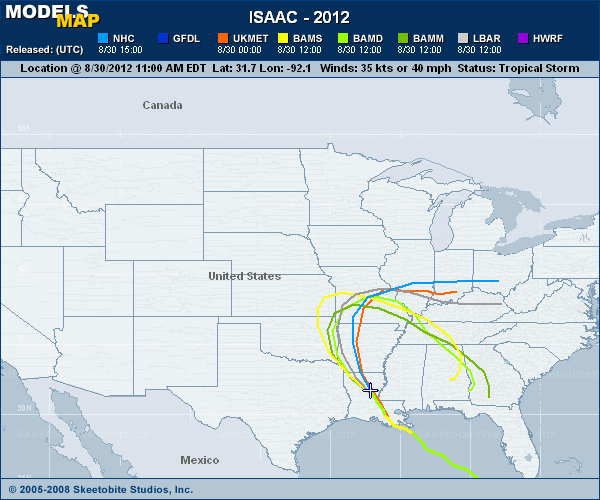
Any chance this eventually travels back SE per the BAM models?
0 likes
Re: ATL: ISAAC - Tropical Storm - Discussion
N2FSU wrote:Any chance this eventually travels back SE per the BAM models?
The BAM models are better in the deep tropical atlantic, otherwise I would be concerned.
0 likes

Who is online
Users browsing this forum: No registered users and 62 guests