ATL: KIRK - Post-Tropical - Discussion
Moderator: S2k Moderators
-
tolakram
- Admin

- Posts: 20178
- Age: 62
- Joined: Sun Aug 27, 2006 8:23 pm
- Location: Florence, KY (name is Mark)
Re: ATL: KIRK - Hurricane
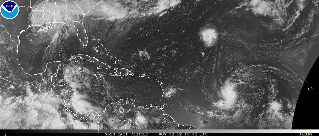
This view gives a reference for the size of Kirk
0 likes
M a r k
- - - - -
Join us in chat: Storm2K Chatroom Invite. Android and IOS apps also available.
The posts in this forum are NOT official forecasts and should not be used as such. Posts are NOT endorsed by any professional institution or STORM2K.org. For official information and forecasts, please refer to NHC and NWS products.

-
Janie2006

- Category 5

- Posts: 1329
- Joined: Mon Sep 18, 2006 3:28 pm
- Location: coastal Ms aka home of the hurricanes
Kirk is living up to his namesake....a swashbuckling, no-holds barred captain.
Seriously, though, an impressive little system, "little" being the operative word here. Hurricane-force winds extending 10 miles from the center, could ramp up in a hurry. Small storms can be very intense. It'll be great watching him go......from a distance.
Seriously, though, an impressive little system, "little" being the operative word here. Hurricane-force winds extending 10 miles from the center, could ramp up in a hurry. Small storms can be very intense. It'll be great watching him go......from a distance.
0 likes
-
tolakram
- Admin
- Posts: 20178
- Age: 62
- Joined: Sun Aug 27, 2006 8:23 pm
- Location: Florence, KY (name is Mark)
Re: ATL: KIRK - Hurricane
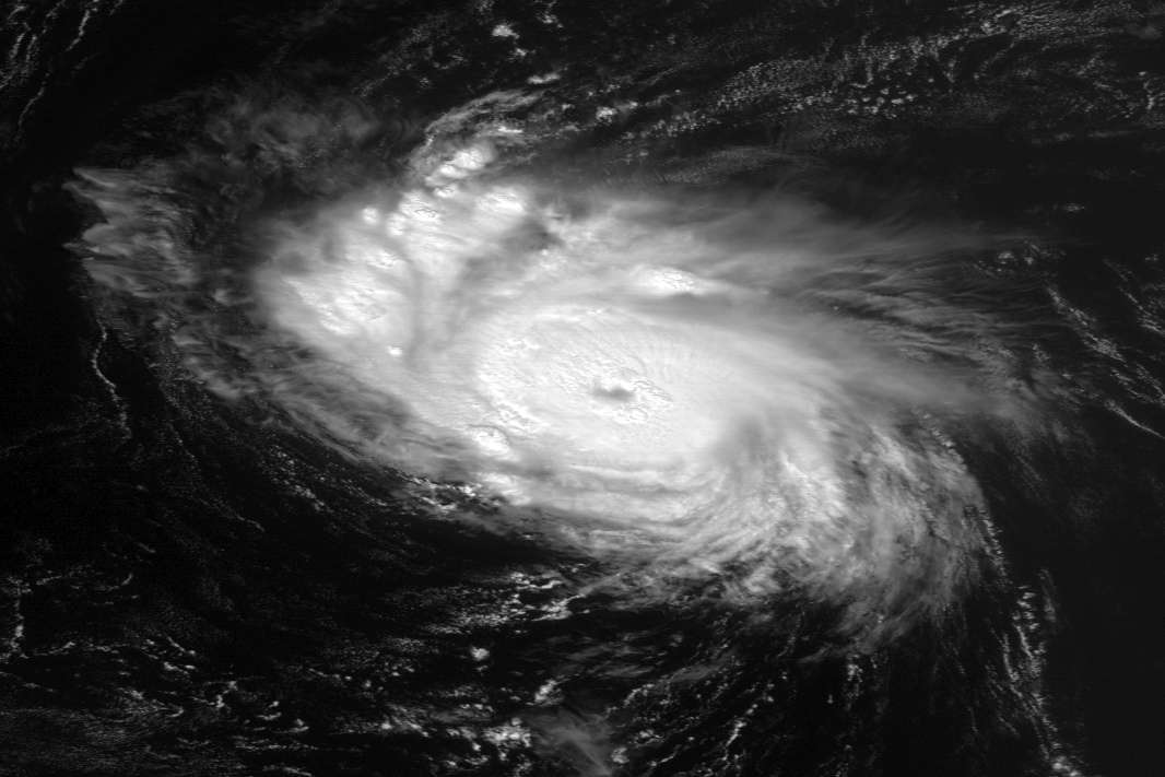
Higher Res view
0 likes
M a r k
- - - - -
Join us in chat: Storm2K Chatroom Invite. Android and IOS apps also available.
The posts in this forum are NOT official forecasts and should not be used as such. Posts are NOT endorsed by any professional institution or STORM2K.org. For official information and forecasts, please refer to NHC and NWS products.
- - - - -
Join us in chat: Storm2K Chatroom Invite. Android and IOS apps also available.
The posts in this forum are NOT official forecasts and should not be used as such. Posts are NOT endorsed by any professional institution or STORM2K.org. For official information and forecasts, please refer to NHC and NWS products.
-
SouthDadeFish

- Professional-Met

- Posts: 2835
- Joined: Thu Sep 23, 2010 2:54 pm
- Location: Miami, FL
- Contact:


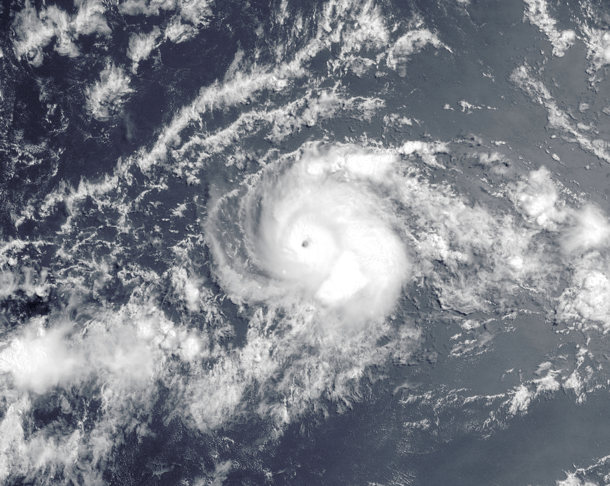
I have few doubts that this will be a major hurricane once all is said and done, its wrapped up really nicely and still strengthening from the looks of things.
0 likes
Personal Forecast Disclaimer:
The posts in this forum are NOT official forecast and should not be used as such. They are just the opinion of the poster and may or may not be backed by sound meteorological data. They are NOT endorsed by any professional institution or storm2k.org. For official information, please refer to the NHC and NWS products
The posts in this forum are NOT official forecast and should not be used as such. They are just the opinion of the poster and may or may not be backed by sound meteorological data. They are NOT endorsed by any professional institution or storm2k.org. For official information, please refer to the NHC and NWS products

-
DESTRUCTION5

- Category 5
- Posts: 4430
- Age: 44
- Joined: Wed Sep 03, 2003 11:25 am
- Location: Stuart, FL
-
ozonepete
- Professional-Met
- Posts: 4743
- Joined: Mon Sep 07, 2009 3:23 pm
- Location: From Ozone Park, NYC / Now in Brooklyn, NY
Re: ATL: KIRK - Hurricane
This is the first time I ever wanted to call a hurricane "cute". lol
0 likes
-
cycloneye

- Admin
- Posts: 149275
- Age: 69
- Joined: Thu Oct 10, 2002 10:54 am
- Location: San Juan, Puerto Rico
Re: ATL: KIRK - Hurricane
18z Best Track up to 75kts
AL, 11, 2012083018, , BEST, 0, 277N, 500W, 75, 984, HU
ftp://ftp.nhc.noaa.gov/atcf/tcweb/inves ... 012.invest
AL, 11, 2012083018, , BEST, 0, 277N, 500W, 75, 984, HU
ftp://ftp.nhc.noaa.gov/atcf/tcweb/inves ... 012.invest
0 likes
Visit the Caribbean-Central America Weather Thread where you can find at first post web cams,radars
and observations from Caribbean basin members Click Here
and observations from Caribbean basin members Click Here

Re:
Cainer wrote:
Carlos peaked as a 105 MPH Cat 2, and I wouldn't be surprised to see Kirk peak somewhere around there as well.
I remmeber Carlos because I was really annoyed that it wasn't upgraded to cat 3 when satellite presentation was really really good but they stuck to Dvorak underestimates.
0 likes
...KIRK RAPIDLY STRENGTHENING OVER THE OPEN ATLANTIC...
Expected to reach 110 MPH now, but could probably easily become our first major hurricane. My opinion only.
Expected to reach 110 MPH now, but could probably easily become our first major hurricane. My opinion only.
0 likes
I'm no expert, everything I say should be taken with a large amount of salt. I could easily be very, very wrong.
~Zanthe Go Coyotes~
~Zanthe Go Coyotes~

Kool Kirk
Macrocane wrote:Cainer wrote:
Carlos peaked as a 105 MPH Cat 2, and I wouldn't be surprised to see Kirk peak somewhere around there as well.
I remmeber Carlos because I was really annoyed that it wasn't upgraded to cat 3 when satellite presentation was really really good but they stuck to Dvorak underestimates.
Same here, I think it was a CAT3 as well. Carlos was one of the more interesting TC's that year.
Hurricane Kirk is super organized and tiny!! I've been waiting for a tiny storm for a while now. I agree with others thinking a major out of Kirk; seems to be the backdoor cyclone of the season (not expected by models or the NHC). The global models have trouble with small hurricanes like this one, Felix (2007), TS Marco (2008), and probably Charley (2004). The odd part of this one is the eye was super clear and round but then became less so quickly after. Reason?
This is one of those storms that actually looks like the name.
0 likes
Re: ATL: KIRK - Hurricane
0 likes
-
cycloneye
- Admin
- Posts: 149275
- Age: 69
- Joined: Thu Oct 10, 2002 10:54 am
- Location: San Juan, Puerto Rico
Re: ATL: KIRK - Hurricane
It has a great shot to be a Major.
INIT 30/2100Z 28.2N 50.3W 80 KT 90 MPH
12H 31/0600Z 29.5N 50.8W 90 KT 105 MPH
24H 31/1800Z 31.8N 50.5W 95 KT 110 MPH
36H 01/0600Z 34.4N 49.0W 95 KT 110 MPH
48H 01/1800Z 37.5N 46.1W 85 KT 100 MPH
INIT 30/2100Z 28.2N 50.3W 80 KT 90 MPH
12H 31/0600Z 29.5N 50.8W 90 KT 105 MPH
24H 31/1800Z 31.8N 50.5W 95 KT 110 MPH
36H 01/0600Z 34.4N 49.0W 95 KT 110 MPH
48H 01/1800Z 37.5N 46.1W 85 KT 100 MPH
0 likes
Visit the Caribbean-Central America Weather Thread where you can find at first post web cams,radars
and observations from Caribbean basin members Click Here
and observations from Caribbean basin members Click Here
-
brunota2003

- S2K Supporter

- Posts: 9476
- Age: 35
- Joined: Sat Jul 30, 2005 9:56 pm
- Location: Stanton, KY...formerly Havelock, NC
- Contact:
Yes, my indicator did pop up for this system. I just came back from the field late last night, so I missed getting to do a forecast of any type.
It appeared around 03 UTC (11 pm EDT)...which would cause the onset of RI to be between 07 to 09 UTC (3 to 5 am EDT). Intensity at 03 UTC was 50 knots, per NHC advisories...which would mean Kirk would RI to at least 80 knots by 11 pm EDT tonight (it is at 80 knots as of the 5 pm EDT advisory).
It appeared around 03 UTC (11 pm EDT)...which would cause the onset of RI to be between 07 to 09 UTC (3 to 5 am EDT). Intensity at 03 UTC was 50 knots, per NHC advisories...which would mean Kirk would RI to at least 80 knots by 11 pm EDT tonight (it is at 80 knots as of the 5 pm EDT advisory).
0 likes
Just a small town southern boy helping other humans.

Re: ATL: KIRK - Hurricane - Discussion
Kirk is a small storm. I think it will be a major hurricane soon. Kirk could be our first major hurricane. Looks like again more storms have formed in the open Atlantic going back to 2010.
0 likes
-
hurricanes1234
- Category 5
- Posts: 2908
- Joined: Sat Jul 28, 2012 6:19 pm
- Location: Trinidad and Tobago
Re: ATL: KIRK - Hurricane
90 mph?! Wow! And it still has the chance to intensify even more! Also, Leslie is expected to become a Category 2 hurricane! An interesting period is to come within the next week or two, for sure! 
My personal prediction for these storms:
1. Kirk is a 90 mph storm right now, because it rapidly strengthened from 75 mph to 90 mph in just 6 hours. Therefore, given the favorable conditions ahead, rapid intensification is a distinct possibility, especially as Kirk is a small hurricane. I would give the system a 50-70% chance of peaking as a major hurricane, and it will be the first of the season, if it is able to overcome the minor issues, which I am pretty sure it would. Throughout its life so far as a tropical cyclone, Kirk has been an overachiever, strengthening into a hurricane from a previously deteriorating tropical wave that was thought to dissipate in somewhat hostile conditions, without even becoming a tropical depression.
2. Leslie is steadily intensifying, it is now a weak tropical storm, from a newly-formed depression just 6 hours ago. Given the hospitable conditions ahead, I would expect this to strengthen into a major hurricane, but gradually. Then, it should weaken in about 5 days, and become extratropical around the time of passing near to Bermuda.
Even better yet, these storms are not likely to impact land, except Leslie could have effects on Bermuda. But, most likely by the time it reaches there, if it does, it would probably be a weak storm. We have two fishes to watch!
0 likes
PLEASE NOTE: With the exception of information from weather agencies that I may copy and paste here, my posts will NEVER be official, since I am NOT a meteorologist. They are solely my amateur opinion, and may or may not be accurate. Therefore, please DO NOT use them as official details, particularly when making important decisions. Thank you.
Re: ATL: KIRK - Hurricane
NHC Discussion wrote:ALTHOUGH KIRK IS EXPECTED TO REMAIN A RELATIVELY COMPACT
CYCLONE...WHICH MAKES IT VULNERABLE TO SLIGHT INCREASES IN VERTICAL
SHEAR AND ENTRAINMENT OF NEARBY DRY AIR...
I thought small/compact hurricanes weren't as vulnerable to dry air as larger ones? I think I disagree with this one, especially considering it was contradicted earlier in the discussion: "KIRK APPEARS TO HAVE BEEN ABLE TO OVERCOME ANY DRY AIR ISSUES".
I believe this is also the first tropical cyclone of the 2012 Atlantic Hurricane Season to officially undergo Rapid Intensification. I certainly didn't expect it to be this one a few days ago!!
0 likes
Who is online
Users browsing this forum: No registered users and 42 guests