
Blown Away wrote:http://img825.imageshack.us/img825/2323/leslie3.jpg
All classified storms within 50 miles of Leslie's current location. WOW, many very significant impacts on the CONUS from this position.
and some of the islands.
Moderator: S2k Moderators
Blown Away wrote:http://img825.imageshack.us/img825/2323/leslie3.jpg
All classified storms within 50 miles of Leslie's current location. WOW, many very significant impacts on the CONUS from this position.


artist wrote:Blown Away wrote:http://img825.imageshack.us/img825/2323/leslie3.jpg
All classified storms within 50 miles of Leslie's current location. WOW, many very significant impacts on the CONUS from this position.
and some of the islands.


Blown Away wrote:The cone is slowly shifting west!.
http://www.nhc.noaa.gov/archive/2012/gr ... p_5W.shtml


cpdaman wrote:Is this thing decoupling or strengthening (I'm on mobile)?

So really a storm could still hit FL if it didn't travel through the 'Hebert Box' and it could very well miss FL if it does Travel through it. In other words the 'Hebert Box' is kinda useless, amirite?wxman57 wrote:Blown Away wrote:I did say all major hurricanes that landfalled in SFL from the east, except for Andrew, passed through the box. Most storms that pass through the Hebert box never hit the CONUS, but if a major hurricane landfalls in SFL, very likely it will have passed through the box.
That's the correct way to interpret it.
cpdaman wrote:Thanks for reply, does anyone know if models shifted closer to islands next couple days bc they (models 0z) have her weaker thru 72 on last nitesruns
otowntiger wrote:So really a storm could still hit FL if it didn't travel through the 'Hebert Box' and it could very well miss FL if it does Travel through it. In other words the 'Hebert Box' is kinda useless, amirite?wxman57 wrote:Blown Away wrote:I did say all major hurricanes that landfalled in SFL from the east, except for Andrew, passed through the box. Most storms that pass through the Hebert box never hit the CONUS, but if a major hurricane landfalls in SFL, very likely it will have passed through the box.
That's the correct way to interpret it.
msbee wrote:I have a question.
do you guys agree with these models?
http://icons-ak.wunderground.com/data/i ... _model.gif
or do you think the Northern islands could be in more of a threat area?
I am concerned that maybe Leslie won't recurve as as NHC says
any comments would be most helpful.
Thanks
Jimsot wrote:msbee wrote:I have a question.
do you guys agree with these models?
http://icons-ak.wunderground.com/data/i ... _model.gif
or do you think the Northern islands could be in more of a threat area?
I am concerned that maybe Leslie won't recurve as as NHC says
any comments would be most helpful.
Thanks
At 11:00AM NHC has the storm moving WNW at 295 degrees, so I am a bit more comfortable now then I was this morning, also due to shear most of the storm is on the eastside away from us. If all continues as NHC says we should be out of the woods by tomorrow afternoon (I hope!).

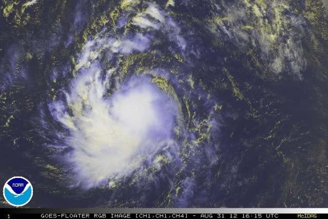
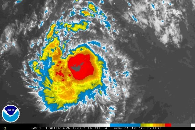

ozonepete wrote:Looks to be intensifying rapidly again. Not necessarily RI, but clearly the shear died out again and there's a huge burst of convection right over the center. Nice banding and good outflow developing.
http://i189.photobucket.com/albums/z174 ... 311615.jpg
http://i189.photobucket.com/albums/z174 ... 311615.jpg

Users browsing this forum: No registered users and 58 guests


