ATL: LESLIE - Post-Tropical - Discussion
Moderator: S2k Moderators
-
floridasun78
- Category 5

- Posts: 3755
- Joined: Sun May 17, 2009 10:16 pm
- Location: miami fl
-
floridasun78
- Category 5
- Posts: 3755
- Joined: Sun May 17, 2009 10:16 pm
- Location: miami fl
Re: ATL: LESLIE - Tropical Storm - Discussion
Cyclenall wrote:ozonepete wrote:It's great for the islands that the NHC doesn't see enough westward movement to change the track. That's the main thing.
I never thought Leslie would get that far west, wxmann57 said there was nothing to keep it near there. But there is one thing I wonder:cpdaman wrote:So long as the mlc is disjoint'd to the sw and the convection with it, this may not turn more poleward asa cat1 or 2 would, although the llc will almost surely be close to the nhc path , remember the convection will likely be sw of it (perhaps) in a way that gives ne islands some convection
Could the northerly shear intensify and keep all the convection to the south, therefore keeping it below CAT2 strength and causing center relocations? If that happens, it could take a much more southern route.
Hurricane Alexis wrote:Is it me or is the NHC not updating the cone and wind field?
Its not just you, I was going to ask the same thing on here. Its very rare for the track cone not to be updated like this on the main page. Its over 1 hour and 10 minutes since the package came out.
floridasun78 wrote:i call them to update their cone
You have their phone number?
their told me not gave it out because their busy but their site issue i can call them
0 likes
-
ozonepete
- Professional-Met

- Posts: 4743
- Joined: Mon Sep 07, 2009 3:23 pm
- Location: From Ozone Park, NYC / Now in Brooklyn, NY
Re: ATL: LESLIE - Tropical Storm - Discussion
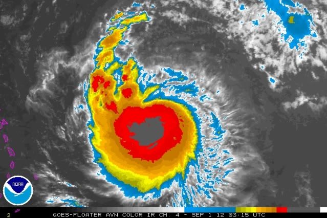
Satellite images now show signs that the turn to the northwest is finally coming. Look at the feeder band and its curve to the north. But it still also looks like Leslie is slowly strengthening even though it's fighting off the shear.
0 likes
-
floridasun78
- Category 5
- Posts: 3755
- Joined: Sun May 17, 2009 10:16 pm
- Location: miami fl
Re: ATL: LESLIE - Tropical Storm - Discussion
ozonepete wrote:Satellite images now show signs that the turn to the northwest is finally coming. Look at the feeder band and its curve to the north. But it still also looks like Leslie is slowly strengthening even though it's fighting off the shear.
http://i189.photobucket.com/albums/z174 ... 010315.jpg
you cannot go with looking at feeder band to see were going
0 likes
-
floridasun78
- Category 5
- Posts: 3755
- Joined: Sun May 17, 2009 10:16 pm
- Location: miami fl
-
ozonepete
- Professional-Met
- Posts: 4743
- Joined: Mon Sep 07, 2009 3:23 pm
- Location: From Ozone Park, NYC / Now in Brooklyn, NY
Re: ATL: LESLIE - Tropical Storm - Discussion
floridasun78 wrote:ozonepete wrote:Satellite images now show signs that the turn to the northwest is finally coming. Look at the feeder band and its curve to the north. But it still also looks like Leslie is slowly strengthening even though it's fighting off the shear.
http://i189.photobucket.com/albums/z174 ... 010315.jpg
you cannot go with looking at feeder band to see were going
Of course you can. You don't look at the fact that it's pointing north. You look at what it tells you about mid-level (roughly 500 mb) cloud motion. The feeder band shows blocking to the west but an open avenue to the north and northwest. The rest of the circulation will follow that open avenue.
0 likes
-
floridasun78
- Category 5
- Posts: 3755
- Joined: Sun May 17, 2009 10:16 pm
- Location: miami fl
Re: ATL: LESLIE - Tropical Storm - Discussion
let see if you right at 5am
let see you right at 5am
ozonepete wrote:floridasun78 wrote:ozonepete wrote:Satellite images now show signs that the turn to the northwest is finally coming. Look at the feeder band and its curve to the north. But it still also looks like Leslie is slowly strengthening even though it's fighting off the shear.
http://i189.photobucket.com/albums/z174 ... 010315.jpg
you cannot go with looking at feeder band to see were going
Of course you can. You don't look at the fact that it's pointing north. You look at what it tells you about mid-level (roughly 500 mb) cloud motion. The feeder band shows blocking to the west but an open avenue to the north and northwest. The rest of the circulation will follow that open avenue.
let see you right at 5am
0 likes
-
ozonepete
- Professional-Met
- Posts: 4743
- Joined: Mon Sep 07, 2009 3:23 pm
- Location: From Ozone Park, NYC / Now in Brooklyn, NY
Re: ATL: LESLIE - Tropical Storm - Discussion
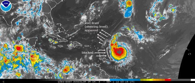
Here's the illustration. Before we had microwave this was one of the only ways to determine tropical cyclone motion overnight, but it still works. Guarantee you that this has got to move northwest now.
0 likes
-
ozonepete
- Professional-Met
- Posts: 4743
- Joined: Mon Sep 07, 2009 3:23 pm
- Location: From Ozone Park, NYC / Now in Brooklyn, NY
Re: ATL: LESLIE - Tropical Storm - Discussion
floridasun78 wrote: let see if you right at 5am
Ok, my friend.
0 likes
-
Kingarabian

- S2K Supporter

- Posts: 16321
- Joined: Sat Aug 08, 2009 3:06 am
- Location: Honolulu, Hawaii
Re: ATL: LESLIE - Tropical Storm - Discussion
ozonepete wrote:floridasun78 wrote: let see if you right at 5am
Ok, my friend.Follow the cloud motion with me and let's see where it is at 5AM.
If Ozonepete is wrong I'll donate 10 dollars to S2K.
0 likes
RIP Kobe Bryant
Re: ATL: LESLIE - Tropical Storm - Discussion
That is a big system for sure...dont yall think?...and this turn takes it clear of the islands?...
0 likes
-
ozonepete
- Professional-Met
- Posts: 4743
- Joined: Mon Sep 07, 2009 3:23 pm
- Location: From Ozone Park, NYC / Now in Brooklyn, NY
Re: ATL: LESLIE - Tropical Storm - Discussion
underthwx wrote:That is a big system for sure...dont yall think?...and this turn takes it clear of the islands?...
Yeah it's big and getting bigger. And yeah it's going to clear the islands. I have a feeling this is going to be around a long time and is going to really load up the ACE for the season...
0 likes
-
somethingfunny

- ChatStaff

- Posts: 3926
- Age: 37
- Joined: Thu May 31, 2007 10:30 pm
- Location: McKinney, Texas
Re: ATL: LESLIE - Tropical Storm - Discussion
Holy mackerel.


This isn't going to hit the islands directly, but maybe a Tropical Storm Watch would be a good idea for the northernmost Leewards just in case Leslie sends some strong rainbands down that way.
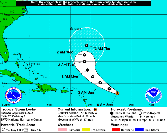
NHC 5 AM Discussion wrote:LESLIE CONTINUES TO PRODUCE A LARGE CENTRAL DENSE OVERCAST WITH A
BAND OF DEEP CONVECTION WRAPPING AROUND THE SOUTHERN AND WESTERN
SEMICIRCLES. DURING THE PAST FEW HOURS...AN EYE-LIKE FEATURE WAS
OBSERVED IN INFRARED SATELLITE IMAGERY EMBEDDED IN THE CENTER OF
THE CDO. HOWEVER...THERE HAVE BEEN NO TIMELY MICROWAVE PASSES...
AND IT IS UNCLEAR IF THIS FEATURE IS COINCIDENT WITH THE LOW-LEVEL
CENTER. STILL...DVORAK ESTIMATES HAVE COME UP TO T4.0 FROM TAFB
AND T3.5 FROM SAB...AND THE INITIAL INTENSITY IS RAISED TO 60 KT.
DESPITE THE UNCERTAINTY IN THE CENTER LOCATION...THE INITIAL MOTION
APPEARS TO BE A LITTLE SLOWER THAN BEFORE AND IS ESTIMATED TO BE
295/15 KT. A DIGGING SHORTWAVE TROUGH OVER THE WESTERN ATLANTIC IS
EXPECTED TO DEVELOP A CUT-OFF LOW DURING THE NEXT 24 HOURS...AND
THIS SHOULD CAUSE THE RIDGE TO THE NORTH OF LESLIE TO WEAKEN.
LESLIE WILL RESPOND BY TURNING NORTHWESTWARD AND THEN NORTHWARD
DURING THE NEXT 5 DAYS...BUT THE CYCLONE WILL ALSO SLOW DOWN AS THE
STEERING FLOW AROUND IT COLLAPSES. ALTHOUGH THERE IS SOME
DIVERGENCE IN THE TRACK GUIDANCE AFTER ABOUT 72 HOURS...THEY ALL
SHOW A SLOW MOTION TOWARD THE NORTH OR EVEN NORTH-NORTHEAST BY DAY
5. THE NEW NHC FORECAST LIES ON THE WESTERN SIDE OF THE GUIDANCE
ENVELOPE...AND IS NUDGED SLIGHTLY EAST OF THE PREVIOUS FORECAST ON
DAYS 4 AND 5.
IF LESLIE IS GOING TO STRENGTHEN...IT PROBABLY HAS TO DO IT DURING
THE NEXT 24 TO 48 HOURS BEFORE IT ENCOUNTERS STRONG WESTERLY TO
NORTHWESTERLY SHEAR. THE UPPER-LEVEL PATTERN COULD THEN BECOME
MORE FAVORABLE FOR STRENGTHENING BY DAY 5. THE INTENSITY MODELS DO
NOT SUPPORT MUCH INTENSIFICATION DURING THE FORECAST PERIOD...AND
THE NEW NHC FORECAST IS LARGELY UNCHANGED FROM THE PREVIOUS ONE BY
INDICATING ONLY GRADUAL STRENGTHENING. THIS FORECAST IS HIGHER
THAN THAT SHOWN BY THE STATISTICAL GUIDANCE...BUT NOT AS HIGH AS
THE INTENSITY CONSENSUS ICON AND HFIP CONSENSUS TV15.
FORECAST POSITIONS AND MAX WINDS
INIT 01/0900Z 17.8N 53.5W 60 KT 70 MPH
12H 01/1800Z 18.8N 55.5W 65 KT 75 MPH
24H 02/0600Z 20.2N 57.7W 65 KT 75 MPH
36H 02/1800Z 21.6N 59.5W 65 KT 75 MPH
48H 03/0600Z 23.1N 60.8W 70 KT 80 MPH
72H 04/0600Z 25.0N 61.5W 70 KT 80 MPH
96H 05/0600Z 26.5N 61.5W 70 KT 80 MPH
120H 06/0600Z 28.5N 61.0W 75 KT 85 MPH
$$
FORECASTER BERG
This isn't going to hit the islands directly, but maybe a Tropical Storm Watch would be a good idea for the northernmost Leewards just in case Leslie sends some strong rainbands down that way.
0 likes
I am not a meteorologist, and any posts made by me are not official forecasts or to be interpreted as being intelligent. These posts are just my opinions and are probably silly opinions.
-
somethingfunny
- ChatStaff
- Posts: 3926
- Age: 37
- Joined: Thu May 31, 2007 10:30 pm
- Location: McKinney, Texas
Re: ATL: LESLIE - Tropical Storm - Discussion
So much green.... 

And I guess the Islands really are in the clear:

And I guess the Islands really are in the clear:
0 likes
I am not a meteorologist, and any posts made by me are not official forecasts or to be interpreted as being intelligent. These posts are just my opinions and are probably silly opinions.
-
ozonepete
- Professional-Met
- Posts: 4743
- Joined: Mon Sep 07, 2009 3:23 pm
- Location: From Ozone Park, NYC / Now in Brooklyn, NY
Re: ATL: LESLIE - Tropical Storm - Discussion
Yeah, the islands are in the clear.
DESPITE THE UNCERTAINTY IN THE CENTER LOCATION...THE INITIAL MOTION APPEARS TO BE A LITTLE SLOWER THAN BEFORE AND IS ESTIMATED TO BE 295/15 KT.
DESPITE THE UNCERTAINTY IN THE CENTER LOCATION...THE INITIAL MOTION APPEARS TO BE A LITTLE SLOWER THAN BEFORE AND IS ESTIMATED TO BE 295/15 KT.
0 likes
-
ozonepete
- Professional-Met
- Posts: 4743
- Joined: Mon Sep 07, 2009 3:23 pm
- Location: From Ozone Park, NYC / Now in Brooklyn, NY
Re: ATL: LESLIE - Tropical Storm - Discussion
floridasun78 wrote:let see you right at 5am
Leslie is totally going to clear the islands. Now we need to talk about where it is going from here, because I know you love this stuff and love speculating on where TCs are going to go. I'm very curious if you agree with the stallout near Bermuda.
0 likes
-
jlauderdal
- S2K Supporter
- Posts: 7240
- Joined: Wed May 19, 2004 5:46 am
- Location: NE Fort Lauderdale
- Contact:
Re: ATL: LESLIE - Tropical Storm - Discussion
ozonepete wrote:underthwx wrote:That is a big system for sure...dont yall think?...and this turn takes it clear of the islands?...
Yeah it's big and getting bigger. And yeah it's going to clear the islands. I have a feeling this is going to be around a long time and is going to really load up the ACE for the season...
We need a long life system to get the ACE up to par, considering the number of storms we have the ACE is really weak.
0 likes
-
Caribwxgirl
- S2K Supporter
- Posts: 287
- Joined: Mon Aug 15, 2011 7:25 pm
- Location: Budapest, Hungary (from Kingston, Jamaica)
What is ACE?
0 likes
Personal Forecast Disclaimer:
The posts in this forum are NOT official forecast. They are just the opinion of the poster and may or may not be backed by sound meteorological data. They are NOT endorsed by any professional institutions or storm2k.org. For official information refer to the NHC and NWS products.
The posts in this forum are NOT official forecast. They are just the opinion of the poster and may or may not be backed by sound meteorological data. They are NOT endorsed by any professional institutions or storm2k.org. For official information refer to the NHC and NWS products.

-
Caribwxgirl
- S2K Supporter
- Posts: 287
- Joined: Mon Aug 15, 2011 7:25 pm
- Location: Budapest, Hungary (from Kingston, Jamaica)
Re: Re:
MJS1 wrote:Caribwxgirl wrote:What is ACE?
A Jet fighter pilot that knocks down at least 3 enemy planes....8)...J/K...I'll look it up the definition for you
0 likes
Personal Forecast Disclaimer:
The posts in this forum are NOT official forecast. They are just the opinion of the poster and may or may not be backed by sound meteorological data. They are NOT endorsed by any professional institutions or storm2k.org. For official information refer to the NHC and NWS products.
The posts in this forum are NOT official forecast. They are just the opinion of the poster and may or may not be backed by sound meteorological data. They are NOT endorsed by any professional institutions or storm2k.org. For official information refer to the NHC and NWS products.
Who is online
Users browsing this forum: No registered users and 44 guests