
.
I'm sorry if this has already been discussed.
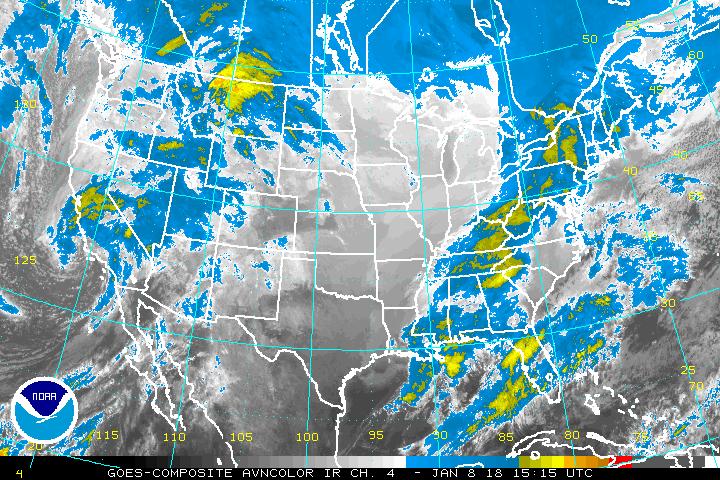
Can someone please tell me if that "tail" that stretches from
the remnants of Isaac all the way across the Texas coast
is part of Isaac? What's happening ?
http://www.ssd.noaa.gov/goes/comp/ceus/avn-l.jpg
Is Isaac going to pull a Hurricane Ivan [come back around and hit the USA again ?]
.
ATL: ISAAC - Post-Tropical - Discussion
Moderator: S2k Moderators
-
somethingfunny

- ChatStaff

- Posts: 3926
- Age: 37
- Joined: Thu May 31, 2007 10:30 pm
- Location: McKinney, Texas
Re: ATL: ISAAC - Post-Tropical - Discussion
BULLETIN - EAS ACTIVATION REQUESTED
FLASH FLOOD WARNING
NATIONAL WEATHER SERVICE NEW ORLEANS LA
304 PM CDT SAT SEP 1 2012
THE NATIONAL WEATHER SERVICE IN NEW ORLEANS HAS ISSUED A
* FLASH FLOOD WARNING FOR...
CENTRAL ST. TAMMANY PARISH IN SOUTHEAST LOUISIANA...
* UNTIL 900 PM CDT
* AT 251 PM CDT...ST TAMMANY PARISH OFFICE OF EMERGENCY MANAGEMENT
REPORTED THAT THE PEARL RIVER DIVERSION CANAL LOCK AND DAM NUMBER
TWO IS ABOUT TO FAIL. HEAVY SCOUR IS TAKING PLACE ALONG SIDE THE
RELIEF SILL. THE CURRENT STAGE IS 18.5 FEET AT BUSH.
THIS IS A FLASH FLOOD EMERGENCY FOR ALL RESIDENTS AND INTEREST
DOWNSTREAM OF PEARL RIVER LOCK AND DAM #2 NEAR BUSH DOWNSTREAM TO
HIGHWAY 36 AT HICKORY.
PRECAUTIONARY/PREPAREDNESS ACTIONS...
FLOOD WATERS WILL MOVE DOWN THE PEARL RIVER DIVERSION CANAL FROM THE
LOCK NUMBER 2 TO HICKORY.
A FLASH FLOOD WARNING MEANS THAT FLOODING IS IMMINENT OR OCCURRING.
IF YOU ARE IN THE WARNING AREA MOVE TO HIGHER GROUND IMMEDIATELY.
RESIDENTS LIVING ALONG STREAMS AND CREEKS SHOULD TAKE IMMEDIATE
PRECAUTIONS TO PROTECT LIFE AND PROPERTY. DO NOT ATTEMPT TO CROSS
SWIFTLY FLOWING WATERS OR WATERS OF UNKNOWN DEPTH BY FOOT OR BY
AUTOMOBILE.
This is for the Pearl River, not the Tangipahoa River that was such a huge concern yesterday.
0 likes
I am not a meteorologist, and any posts made by me are not official forecasts or to be interpreted as being intelligent. These posts are just my opinions and are probably silly opinions.
Re:
toto wrote:.
I'm sorry if this has already been discussed.
Can someone please tell me if that "tail" that stretches from
the remnants of Isaac all the way across the Texas coast
is part of Isaac? What's happening ?
http://www.ssd.noaa.gov/goes/comp/ceus/avn-l.jpg
Is Isaac going to pull a Hurricane Ivan [come back around and hit the USA again ?]
.
The Weather Channel talked about Isaac's "tail" briefly yesterday...
something about part of it coming down as a front or with a front.
Today the "tail" is more pronounced than ever and looks like a front.
Can anyone here explain further ?
Thanks
.
0 likes
-
vbhoutex

- Storm2k Executive

- Posts: 29145
- Age: 74
- Joined: Wed Oct 09, 2002 11:31 pm
- Location: Cypress, TX
- Contact:
Re: Re:
toto wrote:toto wrote:.
I'm sorry if this has already been discussed.
Can someone please tell me if that "tail" that stretches from
the remnants of Isaac all the way across the Texas coast
is part of Isaac? What's happening ?
http://www.ssd.noaa.gov/goes/comp/ceus/avn-l.jpg
Is Isaac going to pull a Hurricane Ivan [come back around and hit the USA again ?]
.
The Weather Channel talked about Isaac's "tail" briefly yesterday...
something about part of it coming down as a front or with a front.
Today the "tail" is more pronounced than ever and looks like a front.
Can anyone here explain further ?
Thanks
.
Basics are that post tropical Issac is still getting some of his moisture feed from the GOM. We had some torrential downpours from that "feeder band" draped across the Texas coast. It did help keep our temps way below the expected highs today. No fronts are expected in our area for another week or so.
0 likes
Skywarn, C.E.R.T.
Please click below to donate to STORM2K to help with the expenses of keeping the site going:

Please click below to donate to STORM2K to help with the expenses of keeping the site going:
-
DoctorBoudreaux

- Tropical Wave

- Posts: 5
- Joined: Tue Aug 21, 2012 6:31 pm
- Location: Texas Gulf Coast
The Wind current web site http://hint.fm/wind/ clearly shows the continuing influence of the remains of Isacc on the weather patterns from the Gulf Coast to the Lake Michigan. Granted it is a low pressure center now with several fronts circling it like spokes on a wheel, but it has amazing persistence! I think the long term effects of Isacc will cause a lot of re-thinking of those folks who minimize the impact of a Cat 1 or TS making landfall anywhere in the US.
0 likes
Personal Forecast Disclaimer:
The posts in this forum are NOT official forecast and should not be used as such. They are just the opinion of the poster and may or may not be backed by sound meteorological data. They are NOT endorsed by any professional institution or storm2k.org. For official information, please refer to the NHC and NWS products.
The posts in this forum are NOT official forecast and should not be used as such. They are just the opinion of the poster and may or may not be backed by sound meteorological data. They are NOT endorsed by any professional institution or storm2k.org. For official information, please refer to the NHC and NWS products.
-
Hybridstorm_November2001

- S2K Supporter

- Posts: 2817
- Joined: Sat Aug 21, 2004 2:50 pm
- Location: SW New Brunswick, Canada
- Contact:
Re:
CrazyC83 wrote:Is there any chance Isaac could make it into the Atlantic and redevelop off the mid-Atlantic coast?
If so it'd be more a typical 'nor'easter' type low than as a TC, judging by both the low & upper level setup.
The following post is NOT an official forecast and should not be used as such. It is just the opinion of the poster and may or may not be backed by sound meteorological data. It is NOT endorsed by any professional institution including storm2k.org For Official Information please refer to the NHC and NWS products.
0 likes
Re: ATL: ISAAC - Post-Tropical - Discussion
One thing for sure...Isaac brought copious amounts of rain to some places that didn't need it - SE FLA, SE LA/MS Gulf Coast....and some places that did...northern LA, AR, TN & MO River Valley

0 likes
-
Hurricane Alexis

- Category 2

- Posts: 683
- Age: 29
- Joined: Thu Jun 14, 2012 7:59 pm
- Location: Miami,Florida
Re: ATL: ISAAC - Post-Tropical - Discussion
So what are the chances of this redeveloping in the GOM as some models are suggesting?
0 likes
Personal Forecast Disclaimer:
The posts in this forum are NOT official forecast and should not be used as such. They are just the opinion of the poster and may or may not be backed by sound meteorological data. They are NOT endorsed by any professional institution or storm2k.org. For official information, please refer to the NHC and NWS products.
The posts in this forum are NOT official forecast and should not be used as such. They are just the opinion of the poster and may or may not be backed by sound meteorological data. They are NOT endorsed by any professional institution or storm2k.org. For official information, please refer to the NHC and NWS products.
Re: ATL: ISAAC - Post-Tropical - Discussion
Hurricane Alexis wrote:
So what are the chances of this redeveloping in the GOM as some models are suggesting?
That's interesting. Do you have a link to those models ?
How about that part of Isaac that is now offshore NC ?
If I remember correctly, that's what crazy Hurricane Ivan did.
.
0 likes
-
Hurricane Alexis
- Category 2
- Posts: 683
- Age: 29
- Joined: Thu Jun 14, 2012 7:59 pm
- Location: Miami,Florida
Re: ATL: ISAAC - Post-Tropical - Discussion
toto wrote:Hurricane Alexis wrote:
So what are the chances of this redeveloping in the GOM as some models are suggesting?
That's interesting. Do you have a link to those models ?
How about that part of Isaac that is now offshore NC ?
If I remember correctly, that's what crazy Hurricane Ivan did.
Use this site. Both the 6z GFS and 00z Euro show this scenario.
http://www.americanwx.com/raleighwx/models.html
.
0 likes
Personal Forecast Disclaimer:
The posts in this forum are NOT official forecast and should not be used as such. They are just the opinion of the poster and may or may not be backed by sound meteorological data. They are NOT endorsed by any professional institution or storm2k.org. For official information, please refer to the NHC and NWS products.
The posts in this forum are NOT official forecast and should not be used as such. They are just the opinion of the poster and may or may not be backed by sound meteorological data. They are NOT endorsed by any professional institution or storm2k.org. For official information, please refer to the NHC and NWS products.
-
Hurricane Alexis
- Category 2
- Posts: 683
- Age: 29
- Joined: Thu Jun 14, 2012 7:59 pm
- Location: Miami,Florida
Re: ATL: ISAAC - Post-Tropical - Discussion
toto wrote:Hurricane Alexis wrote:
So what are the chances of this redeveloping in the GOM as some models are suggesting?
That's interesting. Do you have a link to those models ?
How about that part of Isaac that is now offshore NC ?
If I remember correctly, that's what crazy Hurricane Ivan did.
.
Use this site. Both the 6z GFS and 00z Euro show this scenario.
http://www.americanwx.com/raleighwx/models.html
0 likes
Personal Forecast Disclaimer:
The posts in this forum are NOT official forecast and should not be used as such. They are just the opinion of the poster and may or may not be backed by sound meteorological data. They are NOT endorsed by any professional institution or storm2k.org. For official information, please refer to the NHC and NWS products.
The posts in this forum are NOT official forecast and should not be used as such. They are just the opinion of the poster and may or may not be backed by sound meteorological data. They are NOT endorsed by any professional institution or storm2k.org. For official information, please refer to the NHC and NWS products.
-
Aric Dunn
- Category 5

- Posts: 21238
- Age: 43
- Joined: Sun Sep 19, 2004 9:58 pm
- Location: Ready for the Chase.
- Contact:
the 00z models are more aggressive on what appears to be issac remnants somewhere in the eastern gulf/western atlantic. the euro does eastern gulf along with the cmc. going to be interesting.
0 likes
Note: If I make a post that is brief. Please refer back to previous posts for the analysis or reasoning. I do not re-write/qoute what my initial post said each time.
If there is nothing before... then just ask
Space & Atmospheric Physicist, Embry-Riddle Aeronautical University,
I believe the sky is falling...
If there is nothing before... then just ask
Space & Atmospheric Physicist, Embry-Riddle Aeronautical University,
I believe the sky is falling...
-
cycloneye

- Admin
- Posts: 149276
- Age: 69
- Joined: Thu Oct 10, 2002 10:54 am
- Location: San Juan, Puerto Rico
Re:
Aric Dunn wrote:the 00z models are more aggressive on what appears to be issac remnants somewhere in the eastern gulf/western atlantic. the euro does eastern gulf along with the cmc. going to be interesting.
That is why this thread has remained here and not already in the archieves forum.
0 likes
Visit the Caribbean-Central America Weather Thread where you can find at first post web cams,radars
and observations from Caribbean basin members Click Here
and observations from Caribbean basin members Click Here
-
Aric Dunn
- Category 5
- Posts: 21238
- Age: 43
- Joined: Sun Sep 19, 2004 9:58 pm
- Location: Ready for the Chase.
- Contact:
Re: Re:
cycloneye wrote:Aric Dunn wrote:the 00z models are more aggressive on what appears to be issac remnants somewhere in the eastern gulf/western atlantic. the euro does eastern gulf along with the cmc. going to be interesting.
That is why this thread has remained here and not already in the archieves forum.
yeah looking at sat loops at least to me it appears to be the remnants... interesting the euro keeps it over water for a good amount of time.
0 likes
Note: If I make a post that is brief. Please refer back to previous posts for the analysis or reasoning. I do not re-write/qoute what my initial post said each time.
If there is nothing before... then just ask
Space & Atmospheric Physicist, Embry-Riddle Aeronautical University,
I believe the sky is falling...
If there is nothing before... then just ask
Space & Atmospheric Physicist, Embry-Riddle Aeronautical University,
I believe the sky is falling...
-
superstareporter
- Tropical Low

- Posts: 31
- Joined: Mon Aug 27, 2012 12:06 pm
So where exactly are the remnants located right now, and where can I see the models for this to redevelop? This is extremely interesting to me as I was hit by Ivan almost 4 times! Once in Pensacola, then at my wife's parents in Maryland where we went to the day after the storm, then in Port Charlotte at her sister's where we went after her parents because the house was too small for all of us, then we left there to go home to check on our stuff and Ivan headed back to Pensacola only to drift to SETX/LA. That was a storm that NEVER seemed to want to go away!!
0 likes
-
Hurricanehink

- S2K Supporter
- Posts: 2045
- Joined: Sun Nov 16, 2003 2:05 pm
- Location: New Jersey
Re:
CrazyC83 wrote:If it drifts into water and redevelops, it is still Isaac and not Nadine?
I still (respectably) disagree with the NHC's decision on Ivan, mostly how the area was devastated by the storm, and then it came back a week later. The storms are supposed to be named to prevent confusion, but a situation like this only enhances the confusion, IMO. I think we'll find out the NHC's decision when (and if) a TWO is issued. http://www.nhc.noaa.gov/archive/text/TWOAT/2004/TWOAT.200409201526 - in the first TWO that mentioned Ivan's remnants, they emphasized the connection to Ivan.
Disclaimer: this is not a forecast, just some ramblings by an amateur.
0 likes
-
CrazyC83
- Professional-Met

- Posts: 34315
- Joined: Tue Mar 07, 2006 11:57 pm
- Location: Deep South, for the first time!
Re: Re:
Hurricanehink wrote:CrazyC83 wrote:If it drifts into water and redevelops, it is still Isaac and not Nadine?
I still (respectably) disagree with the NHC's decision on Ivan, mostly how the area was devastated by the storm, and then it came back a week later. The storms are supposed to be named to prevent confusion, but a situation like this only enhances the confusion, IMO. I think we'll find out the NHC's decision when (and if) a TWO is issued. http://www.nhc.noaa.gov/archive/text/TWOAT/2004/TWOAT.200409201526 - in the first TWO that mentioned Ivan's remnants, they emphasized the connection to Ivan.
Disclaimer: this is not a forecast, just some ramblings by an amateur.
Does anyone remember if they gave the "Ivan" low (before regenesis) a new Invest number or kept it as 09L? That would be a good indicator on what the NHC decides if this gets back to water.
0 likes
-
superstareporter
- Tropical Low
- Posts: 31
- Joined: Mon Aug 27, 2012 12:06 pm
Re: ATL: ISAAC - Post-Tropical - Discussion
I cant find anywhere that mentions where the remnants are right now, and where they are predicted to emerge into water HELP!
0 likes
Who is online
Users browsing this forum: No registered users and 77 guests