ENSO Updates (2007 thru 2023)
Moderator: S2k Moderators
Forum rules

The posts in this forum are NOT official forecasts and should not be used as such. They are just the opinion of the poster and may or may not be backed by sound meteorological data. They are NOT endorsed by any professional institution or STORM2K. For official information, please refer to products from the National Hurricane Center and National Weather Service.
-
Kingarabian

- S2K Supporter

- Posts: 16364
- Joined: Sat Aug 08, 2009 3:06 am
- Location: Honolulu, Hawaii


Re:
Kingarabian wrote:Ntxw can you post the 1992 pacific SST anomalies?
Which month would you like to see?
0 likes
The above post and any post by Ntxw is NOT an official forecast and should not be used as such. It is just the opinion of the poster and may or may not be backed by sound meteorological data. It is NOT endorsed by any professional institution including Storm2k. For official information, please refer to NWS products.
Help support Storm2K!
-
Kingarabian
- S2K Supporter
- Posts: 16364
- Joined: Sat Aug 08, 2009 3:06 am
- Location: Honolulu, Hawaii
Re: Re:
Ntxw wrote:Kingarabian wrote:Ntxw can you post the 1992 pacific SST anomalies?
Which month would you like to see?
September.
0 likes
RIP Kobe Bryant
Here you go

Here's the site I got from and use for past SST's from NOAA-NOMADS reconstructed all the way back to 1895 for any month. Pm me if you need any help using it
http://nomads.ncdc.noaa.gov/las/getUI.do
Here's the site I got from and use for past SST's from NOAA-NOMADS reconstructed all the way back to 1895 for any month. Pm me if you need any help using it
http://nomads.ncdc.noaa.gov/las/getUI.do
0 likes
The above post and any post by Ntxw is NOT an official forecast and should not be used as such. It is just the opinion of the poster and may or may not be backed by sound meteorological data. It is NOT endorsed by any professional institution including Storm2k. For official information, please refer to NWS products.
Help support Storm2K!
Help support Storm2K!
-
Kingarabian
- S2K Supporter
- Posts: 16364
- Joined: Sat Aug 08, 2009 3:06 am
- Location: Honolulu, Hawaii
No big changes from the ENSO update today. 3.4 did cool a little but not anything significant. Something we can look at is the sub-surface where there are changes. 4c anomalies returning just under 120W upwelling and new warming around 140E which supports the oceanic kelvin wave mentioned in yesterday's posts.
http://www.cpc.ncep.noaa.gov/products/a ... zteq.shtml
This nino is battling some of the coldest PDO stretches we've seen in recent memory. The fact it's still alive is remarkable and will be interesting to see how it works out in the winter months.
http://www.cpc.ncep.noaa.gov/products/a ... zteq.shtml
This nino is battling some of the coldest PDO stretches we've seen in recent memory. The fact it's still alive is remarkable and will be interesting to see how it works out in the winter months.
0 likes
The above post and any post by Ntxw is NOT an official forecast and should not be used as such. It is just the opinion of the poster and may or may not be backed by sound meteorological data. It is NOT endorsed by any professional institution including Storm2k. For official information, please refer to NWS products.
Help support Storm2K!
Help support Storm2K!
-
weatherdude1108
- Category 5

- Posts: 4228
- Joined: Tue Dec 13, 2011 1:04 pm
- Location: Northwest Austin/Cedar Park, TX
Re: ENSO Updates
Statistical models are like climatology. They are simpler than dynamical models in that they take the data set and perform almost in linear fashion based on similar events of the past. Dynamical models are more complex and can calculate the immediate and down the road changes. The globals are dynamical models, Euro-GFS-Canadian etc.
0 likes
The above post and any post by Ntxw is NOT an official forecast and should not be used as such. It is just the opinion of the poster and may or may not be backed by sound meteorological data. It is NOT endorsed by any professional institution including Storm2k. For official information, please refer to NWS products.
Help support Storm2K!
Help support Storm2K!

Re: ENSO Updates
I know we pay more attention to the 90 day SOI average, but looking at the 30 day SOI avergae is interesting for sure. It's now in the positive.
Date Tahiti Darwin Daily** 30 day avg SOI 90 day avg SOI
11 Sep 2012 1015.64 1012.05 7.55 1.68 -3.99
http://www.longpaddock.qld.gov.au/seasonalclimateoutlook/southernoscillationindex/30daysoivalues/
Date Tahiti Darwin Daily** 30 day avg SOI 90 day avg SOI
11 Sep 2012 1015.64 1012.05 7.55 1.68 -3.99
http://www.longpaddock.qld.gov.au/seasonalclimateoutlook/southernoscillationindex/30daysoivalues/
0 likes
Personal Forecast Disclaimer:
The posts in this forum are NOT official forecast and should not be used as such. They are just the opinion of the poster and may or may not be backed by sound meteorological data. They are NOT endorsed by any professional institution or storm2k.org. For official information, please refer to the NHC and NWS products.
The posts in this forum are NOT official forecast and should not be used as such. They are just the opinion of the poster and may or may not be backed by sound meteorological data. They are NOT endorsed by any professional institution or storm2k.org. For official information, please refer to the NHC and NWS products.
Re: CPC 9/4/12 :Nino 3.4 up to +0.9C/Nino 1+2 down to -0.2C
Ntxw wrote:LarryWx wrote:That as well as MJJ both look very suspect. MJJ should have been ~+0.3 instead of 0.0 while JJA should have been ~+0.5 instead of +0.1 based on the weeklies. Somebody needs to call them and get the lowdown or get them to correct these ONI's.
Wow, you noticed it too. I thought I was crazy looking back at the weeklies since April when it didn't add up for me
Ntxw/Folks,
This morning, I called CPC/NOAA and talked to them about the past two very low ONI #'s in relation to the weeklies. They are fully aware of the inconsistencies and are investigating. One of the problems is that the ONI is based on ERSST data, which comes from the NCDC in Asheville. OTOH, the weeklies are based on OISST data, a different dataset. They acknowledged that the ONI is deceivingly low vs. the weeklies and that they are curently basing their weekly Mon. updates mainly on the weeklies, not the ONI, because they feel that the weeklies are "much more reliable than the ONI" right now. One reason they don't just want to stop using ERSST is because it goes back so far in time...to the late 1800's and they actively use it going back to 1950. In contrast, the OISST data goes back only to 1980 for monthly and 1990 for weekly.
They are already in touch with the NCDC about the disconnect and feel it will take a good bit of time to diagnose the situation. They aren't even sure there actually is an actual data problem with ERSST as it may be a statistical/interpolation/rounding issue being the main cause. I plan to follow up with them in about a month.
With this telecon in mind, I've decided to take the three month average of the weeklies and use that to approximate the "official" ONI until the ONI inconsistency issue itself, is resolved. This is a major change for me because I have been using the ONI table for the better part of ten years to determine "official" ENSO phases and NOAA has been using it for "official" determinations.
I'm going with +0.3 for MJJ and +0.5 for JJA for the approximated ONI. My educated guess is that JAS will end up ~+0.7 based on the weeklies. In order for me to count this as a weak Nino instead of neutral positive, there will need to be at least five trimonths in a row of +0.5+ as per the NOAA requirement. With JAS, we'll have two. Barring something totally unforeseen, ASO will be the third. I'm confident based on the models as well as history that SON and OND will also be +0.5+...that would make it an official weak Nino as far as I'm concerned assuming none exceed +1.0 as I expect. Keep in mind that the weeklies can spike as high as ~+1.4 and still allow for no more than a +1.0 three month average based on the past. The latest weekly was +0.8, down from +0.9 a week earlier.
0 likes
Personal Forecast Disclaimer:
The posts in this forum are NOT official forecasts and should not be used as such. They are just the opinion of the poster and may or may not be backed by sound meteorological data. They are NOT endorsed by any professional institution or storm2k.org. For official information, please refer to the NHC and NWS products.
The posts in this forum are NOT official forecasts and should not be used as such. They are just the opinion of the poster and may or may not be backed by sound meteorological data. They are NOT endorsed by any professional institution or storm2k.org. For official information, please refer to the NHC and NWS products.
Ah ok that makes sense. Thanks LarryWx for contacting them, it clears up a lot of confusion. Your thoughts on the ONI values based on weeklies sounds much more reasonable. I do have a question, is it possible the inconsistencies have any effect on past ONI values that would need to be re-evaluated?
0 likes
The above post and any post by Ntxw is NOT an official forecast and should not be used as such. It is just the opinion of the poster and may or may not be backed by sound meteorological data. It is NOT endorsed by any professional institution including Storm2k. For official information, please refer to NWS products.
Help support Storm2K!
Help support Storm2K!
Re:
Ntxw wrote:Ah ok that makes sense. Thanks LarryWx for contacting them, it clears up a lot of confusion. Your thoughts on the ONI values based on weeklies sounds much more reasonable. I do have a question, is it possible the inconsistencies have any effect on past ONI values that would need to be re-evaluated?
Ntxw,
You're welcome. I think that is possible. We'll see what they conclude. I do know that past calculations on my part have usually yielded pretty close to the ONI when averaging the weeklies over a three month period though they'd fairly often be 0.1 off. On occasion, I've seen them differ by 0.2. Anything over 0.2 off was pretty rare based on my recollections other than being near a peak/dip.
0 likes
Personal Forecast Disclaimer:
The posts in this forum are NOT official forecasts and should not be used as such. They are just the opinion of the poster and may or may not be backed by sound meteorological data. They are NOT endorsed by any professional institution or storm2k.org. For official information, please refer to the NHC and NWS products.
The posts in this forum are NOT official forecasts and should not be used as such. They are just the opinion of the poster and may or may not be backed by sound meteorological data. They are NOT endorsed by any professional institution or storm2k.org. For official information, please refer to the NHC and NWS products.
-
weatherdude1108
- Category 5
- Posts: 4228
- Joined: Tue Dec 13, 2011 1:04 pm
- Location: Northwest Austin/Cedar Park, TX
First mention of "El Nino" I have seen in the discussion. 
AREA FORECAST DISCUSSION
NATIONAL WEATHER SERVICE AUSTIN/SAN ANTONIO TX
336 PM CDT TUE SEP 11 2012
.UPDATE...
/RESENT FOR CORRECTION TO PRELIMINARY NUMBERS/
&&
.PREV DISCUSSION... /ISSUED 322 PM CDT TUE SEP 11 2012/
DISCUSSION...
THE WEATHER PATTERN OVER TX THE NEXT FEW DAYS WILL BEGIN TO
REFLECT SOME OF THE POTENTIAL BENEFITS OF DEVELOPING EL NINO
CONDITIONS OVER THE PACIFIC FOR SEPTEMBER. MOISTURE RETURN
ACCELERATES OVER SOUTH CENTRAL TX TONIGHT AS MID-LEVEL TROUGHING
CONTINUES TO DEVELOP OVER THE SWRN US. THE MODEL TRENDS CONTINUE
TO EXPAND ON RAIN CHANCES OVER A BROADER PERIOD WITH A WEAK COLD
FRONT STILL EXPECTED TO MOVE INTO THE REGION BY THURSDAY NIGHT.
THE FRONT IS NOT EXPECTED TO MAKE A STRONG PUSH THANKS TO
CONTINUED UPSTREAM DIGGING OF THE UPPER TROUGH. THE RESULT IS A
FAVORABLE SCENARIO FOR MESOSCALE CONVECTIVE SYSTEMS WHICH ARE
FIRST EXPECTED OVER WEST TX BY THURSDAY AFTERNOON AND INTO OUR WRN
COUNTIES THURSDAY EVENING. MODEL VARIABILITY STILL EXISTS FOR
TIMING AND BEST RAIN CHANCES...BUT THE MODEL TRENDS OF INCREASED
UPSTREAM TROUGHING SUGGEST BEST RAINFALL POTENTIAL OVER WESTERN
COUNTIES INITIALLY THURSDAY NIGHT WITH THE LATER PERIODS OF FRIDAY
AND SATURDAY FAVORING SOUTH AND EASTERN COUNTIES. GIVEN THIS
INCREASED TROUGHING TREND IN THE WESTERLIES...A SLIGHT MOISTURE TAP
WILL DEVELOP FROM THE UNSTABLE EASTERN PACIFIC TROPICS WHERE NHC
IS PROJECTING FAVORABLE CONDITIONS FOR A DEPRESSION NEAR 14N 102W.INITIAL MOISTURE POOLING ALONG THE FRONT MAY NOT SUPPORT HEAVY
RAINS...BUT AN OVERRUNNING PATTERN AND CONTINUED DEEPENING OF THE
UPPER TROUGH COULD SUPPORT SCATTERED CONVECTION OVER A BROAD AREA
OF SOUTH TX THROUGH AT LEAST DAYTIME SATURDAY. FOR THE PERIOD
THURSDAY AFTERNOON THROUGH SATURDAY AFTERNOON...WILL TAKE AN
AVERAGE OF MODEL SOLUTIONS AND EXPECT AREAL QPF AMOUNTS OF 1/4 TO
1/2 INCH WITH ISOLATED 1-2 INCH AMOUNTS.
ON SUNDAY THE SLIGHTLY MORE PROGRESSIVE AND DRIER GFS IS
PREFERRED WHICH CARRIES THE UPPER DISTURBANCE INTO E TX/LA. THE
PROGRESSIVE PATTERN SHOULD FAVOR SEASONAL TEMPERATURES AND A FAIR
AMOUNT OF RESIDUAL MOISTURE THAT COULD SUPPORT SOME CONVECTION
WHEN A WEAK DISTURBANCE DROPS SE ACROSS TX NEXT TUESDAY.
0 likes
The preceding post is NOT an official forecast, and should not be used as such. It is only the opinion of the poster and may or may not be backed by sound meteorological data. It is NOT endorsed by any professional institution including storm2k.org. For Official Information please refer to the NHC and NWS products.
There seems to be some mixed signals going on in the Pacific. SST's at 3.4 may cool this week once again at the surface but the pattern and sub-surface is changing very drastically. It may be the cooling is a process of the transition for some sustained warming once the oceanic kelvin wave from the WPAC arrives I'm not certain yet, but also the weather pattern in the pacific and tropics could create a feed back result (Pattern allowing warming, warming causing more of that pattern). We'll have to see, this Nino has been two steps forward one step back since July.
CFSv2 has been all over the place trying to forecast this Nino so I'm hesitant to rely on it atm.
CFSv2 has been all over the place trying to forecast this Nino so I'm hesitant to rely on it atm.
0 likes
The above post and any post by Ntxw is NOT an official forecast and should not be used as such. It is just the opinion of the poster and may or may not be backed by sound meteorological data. It is NOT endorsed by any professional institution including Storm2k. For official information, please refer to NWS products.
Help support Storm2K!
Help support Storm2K!
-
ozonepete
- Professional-Met

- Posts: 4743
- Joined: Mon Sep 07, 2009 3:23 pm
- Location: From Ozone Park, NYC / Now in Brooklyn, NY
Re:
Ntxw wrote:There seems to be some mixed signals going on in the Pacific. SST's at 3.4 may cool this week once again at the surface but the pattern and sub-surface is changing very drastically. It may be the cooling is a process of the transition for some sustained warming once the oceanic kelvin wave from the WPAC arrives I'm not certain yet, but also the weather pattern in the pacific and tropics could create a feed back result (Pattern allowing warming, warming causing more of that pattern). We'll have to see, this Nino has been two steps forward one step back since July.
CFSv2 has been all over the place trying to forecast this Nino so I'm hesitant to rely on it atm.
More like one step forward one and one and a quarter steps back. I don't know how these current surface anomalies, which are trending against an El Nino, are going to help the matter. It looked reasonable when the surface water temps north of Australia up to southeast Asia were getting so much below normal, but now they are trending the other way. And the positive anomalies in the eastern PAC near central America are dropping off. Not what one would expect in a developing El Nino at all.
Analyzing and predicting these events is a very young science with a very shaky track record for forecasting them so far. But please don't get me wrong, I am impressed by how far we've come and I follow this all of the time. But we have a long way to go.
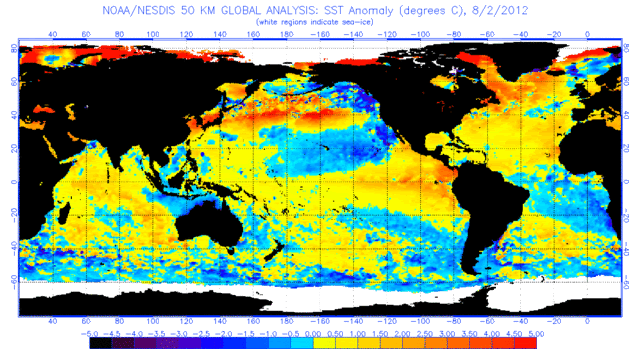
AUGUST 2nd SURFACE SST ANOMALIES
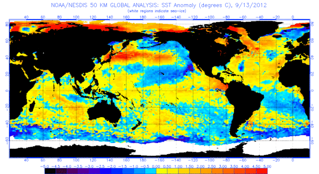
SEPTEMBER 13 SURFACE SST ANOMALIES
0 likes
ozonepete wrote:More like one step forward one and one and a quarter steps back. I don't know how these current surface anomalies, which are trending against an El Nino, are going to help the matter. It looked reasonable when the surface water temps north of Australia up to southeast Asia were getting so much below normal, but now they are trending the other way. And the positive anomalies in the eastern PAC near central America are dropping off. Not what one would expect in a developing El Nino at all.
I do agree predicting ENSO can be compared to predicting a hurricane. Intensity is still a problem but we have the gist of a general track which of course can change the last minute but most of the time it's pretty decent. However looking at ENSO is more than just the temperatures at the surface, it is the prevailing winds and sub-surface pools. Cold anomalies in the East Pac are not unusual in CP El Ninos. We are not trending away from El Nino, but rather El Nino is fighting off the cold PDO.
The Enso changes that started earlier this week has continued to progress. Most dramatic of all has been 1+2. The sub-surface warm pool that warmed in the last update is moving up and we see the drastic rise. Though 3.4 leveled off, the warmer 3 and 1+2 is heading west to re-establish it while 4 is benefiting from the kelvin wave. MJO is looking very favorable now since July and convection in the tropical pacific is uniform and widespread.


0 likes
The above post and any post by Ntxw is NOT an official forecast and should not be used as such. It is just the opinion of the poster and may or may not be backed by sound meteorological data. It is NOT endorsed by any professional institution including Storm2k. For official information, please refer to NWS products.
Help support Storm2K!
Help support Storm2K!
-
South Texas Storms

- Professional-Met
- Posts: 4258
- Joined: Thu Jun 24, 2010 12:28 am
- Location: Houston, TX
Re: ENSO Updates
With all of that said, so you think 3.4 will warm up again nicely next week?
0 likes
Think it will South Texas Storms, how long I am not sure probably not by Monday. hopefully Monday's update will give us a better idea when we see the how much the sub-surface has changed at what locations from this week.
0 likes
The above post and any post by Ntxw is NOT an official forecast and should not be used as such. It is just the opinion of the poster and may or may not be backed by sound meteorological data. It is NOT endorsed by any professional institution including Storm2k. For official information, please refer to NWS products.
Help support Storm2K!
Help support Storm2K!
-
cycloneye

- Admin

- Posts: 149472
- Age: 69
- Joined: Thu Oct 10, 2002 10:54 am
- Location: San Juan, Puerto Rico
Re: ENSO Updates
While what our friend Ntxw posts those important graphics of warming in many areas of the Pacific,a blow/mixed/puzzeling signal to that is the continued rise of the 30 day SOI that is well above the line between Positive and Negative.

0 likes
Visit the Caribbean-Central America Weather Thread where you can find at first post web cams,radars
and observations from Caribbean basin members Click Here
and observations from Caribbean basin members Click Here
-
ozonepete
- Professional-Met
- Posts: 4743
- Joined: Mon Sep 07, 2009 3:23 pm
- Location: From Ozone Park, NYC / Now in Brooklyn, NY
Re:
Ntxw wrote:ozonepete wrote:More like one step forward one and one and a quarter steps back. I don't know how these current surface anomalies, which are trending against an El Nino, are going to help the matter. It looked reasonable when the surface water temps north of Australia up to southeast Asia were getting so much below normal, but now they are trending the other way. And the positive anomalies in the eastern PAC near central America are dropping off. Not what one would expect in a developing El Nino at all.
I do agree predicting ENSO can be compared to predicting a hurricane. Intensity is still a problem but we have the gist of a general track which of course can change the last minute but most of the time it's pretty decent. However looking at ENSO is more than just the temperatures at the surface, it is the prevailing winds and sub-surface pools. Cold anomalies in the East Pac are not unusual in CP El Ninos. We are not trending away from El Nino, but rather El Nino is fighting off the cold PDO.
I can't blame you for commenting that "looking at ENSO is more than just the temperatures at the surface, it is the prevailing winds and sub-surface pools." But I did know that - just wasn't commenting on it in my post.
Also, I specifically never said we are trending away from an El Nino. I said that the trends of surface SSTs that are a major part of measuring whether we are going into an El Nino are not trending the way we would expect. What it looks like is that we are trending toward a very weak El Nino that is now overdue and looks like it won't last long, in no small part because yes, it is fighting off the cold PDO and is not "winning."
0 likes
Who is online
Users browsing this forum: Google Adsense [Bot] and 183 guests