ENSO Updates (2007 thru 2023)

This is the general tropical discussion area. Anyone can take their shot at predicting a storms path.

Moderator: S2k Moderators

Forum rules

The posts in this forum are NOT official forecasts and should not be used as such. They are just the opinion of the poster and may or may not be backed by sound meteorological data. They are NOT endorsed by any professional institution or STORM2K. For official information, please refer to products from the National Hurricane Center and National Weather Service.

Help Support Storm2K
Message
Author
LarryWx
S2K Supporter
S2K Supporter
Posts: 6305
Joined: Sun Sep 07, 2003 2:04 pm
Location: GA

Re:

#2601 Postby LarryWx » Mon Sep 24, 2012 9:39 am

NDG wrote:I am not saying that El Nino is dead, but chances of at least a moderate El Nino have really decreased due to the current trends and with the latest models' concensus pointing at a barely weak El Nino.


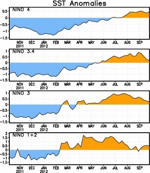
I agree about moderate. Actually, I've been saying weak Nino peak is most likely for this fall/winter (based on SOI and other variables) since well back in the summer with low end moderate (+1.1 to +1.2 ONI) 2nd most likely and high end moderate to strong down to almost 0. For me, this recent drop just raises weak Nino peak chances at the expense of the already pretty small low end moderate chance. I have the chance for not getting five trimonthlies in a row of +0.5+ (i.e., neutral positive instead of weak Nino) at very low. Keep in mind that the current ONI table's ONI #'s for MJJ and especially JJA are quite a bit too cool based on what the NOAA/NCEP people recently told me as well as based on looking at the weeklies. JJA should have said ~+0.5. Also, JAS will be +0.5+ based on the weeklies even if the next two weeks cool to 0.0.
Last edited by LarryWx on Mon Sep 24, 2012 11:10 am, edited 1 time in total.
0 likes   
Personal Forecast Disclaimer:
The posts in this forum are NOT official forecasts and should not be used as such. They are just the opinion of the poster and may or may not be backed by sound meteorological data. They are NOT endorsed by any professional institution or storm2k.org. For official information, please refer to the NHC and NWS products.

User avatar
wxman57
Moderator-Pro Met
Moderator-Pro Met
Posts: 22979
Age: 67
Joined: Sat Jun 21, 2003 8:06 pm
Location: Houston, TX (southwest)

Re: ENSO Updates

#2602 Postby wxman57 » Mon Sep 24, 2012 10:11 am

Interesting, the weeklies (13 reports) average out to +0.53 and not 0.1. In fact, all reports were above +0.1 with the exception of the first on June 6th.
0 likes   

LarryWx
S2K Supporter
S2K Supporter
Posts: 6305
Joined: Sun Sep 07, 2003 2:04 pm
Location: GA

Re: ENSO Updates

#2603 Postby LarryWx » Mon Sep 24, 2012 11:12 am

wxman57 wrote:Interesting, the weeklies (13 reports) average out to +0.53 and not 0.1. In fact, all reports were above +0.1 with the exception of the first on June 6th.


Per what NOAA/NCEP told me, the SST datasets for the weeklies and for the ONI table are different. Even so, the weeklies and ONI table shouldn't be this far apart. That's why they are using the data that determines the weeklies for now for their weekly ENSO reports.
0 likes   
Personal Forecast Disclaimer:
The posts in this forum are NOT official forecasts and should not be used as such. They are just the opinion of the poster and may or may not be backed by sound meteorological data. They are NOT endorsed by any professional institution or storm2k.org. For official information, please refer to the NHC and NWS products.

User avatar
Ntxw
Storm2k Moderator
Storm2k Moderator
Posts: 22785
Joined: Wed Oct 21, 2009 6:34 pm
Location: DFW, Texas

Re: ENSO Updates

#2604 Postby Ntxw » Mon Sep 24, 2012 11:44 am

Here's the updated daily anoms. For the past 3 days or so the warmth has been expanding from the west.

Image

http://www.esrl.noaa.gov/psd/map/clim/s ... .week.html

Means next week's update will likely rise from the 0.3c

Question on the ONI and various SST factors, is it possible that the new normals (from 71-00 to 81-10 - obviously warmer base period now) are causing the problems? You would need even warmer temps than before to have higher anomalies than the previous base to show what it did before. It's the first Nino since the change so I was wondering if that may be a culprit unless they have adjusted for it?
Last edited by Ntxw on Mon Sep 24, 2012 12:06 pm, edited 1 time in total.
0 likes   
The above post and any post by Ntxw is NOT an official forecast and should not be used as such. It is just the opinion of the poster and may or may not be backed by sound meteorological data. It is NOT endorsed by any professional institution including Storm2k. For official information, please refer to NWS products.

  Help support Storm2K!
Help Support Storm2K

User avatar
cycloneye
Admin
Admin
Posts: 145322
Age: 68
Joined: Thu Oct 10, 2002 10:54 am
Location: San Juan, Puerto Rico

Re: ENSO: CPC 9/24/12 Update=Nino 3.4 down to +0.3C

#2605 Postby cycloneye » Mon Sep 24, 2012 12:05 pm

Here is the CPC update that cools down Nino 3.4 to +0.3C. The most rapid decline was at 3.4.

http://www.cpc.ncep.noaa.gov/products/a ... ts-web.pdf

Image
0 likes   
Visit the Caribbean-Central America Weather Thread where you can find at first post web cams,radars
and observations from Caribbean basin members Click Here

LarryWx
S2K Supporter
S2K Supporter
Posts: 6305
Joined: Sun Sep 07, 2003 2:04 pm
Location: GA

Re: ENSO Updates

#2606 Postby LarryWx » Mon Sep 24, 2012 12:27 pm

Ntxw wrote:Here's the updated daily anoms. For the past 3 days or so the warmth has been expanding from the west.

http://www.esrl.noaa.gov/psd/map/clim/s ... .week.html

Means next week's update will likely rise from the 0.3c


Regarding the PDO when looking at the movie, one can see very clearly how much it has cooled over the last two weeks in the area south of the Aleutians from ~37-45N, 150W-170E. Although I had already noted some cooling around 40N, 170W in recent days, this movie clearly shows that the area that cooled was much bigger than I had realized and with significant magnitude. It has also warmed some in the Gulf of Alaska. This cooling/warming combo tells me that the PDO has risen significantly over the last two weeks. This is telling me that the recent -EPO has probably helped warm the PDO (that chicken-egg thing). As it stands now, I feel safe in saying that the Sep 2012 PDO (which is averaged over the entire month) will likely come in a good bit less negative than Aug 2012. I have been going with only about a 1 in 3 chance for the upcoming DJF PDO to average positive. IF the recent increasing PDO trends were to continue well into October (even at a slower pace). I would then probably raise the chance to close to 1 in 2. However, the EPO looks to go into a more positive phase for at least a week or so. Let's see whether or not that reverses much of the recent PDO increases.
0 likes   
Personal Forecast Disclaimer:
The posts in this forum are NOT official forecasts and should not be used as such. They are just the opinion of the poster and may or may not be backed by sound meteorological data. They are NOT endorsed by any professional institution or storm2k.org. For official information, please refer to the NHC and NWS products.

User avatar
SoupBone
Category 5
Category 5
Posts: 3111
Joined: Tue Sep 20, 2005 5:24 pm

Re: ENSO: CPC 9/24/12 Update=Nino 3.4 down to +0.3C

#2607 Postby SoupBone » Mon Sep 24, 2012 3:40 pm

Are there going to be any winter 2012-2013 graphics updates for the US now that it looks like El Nino might not be as strong as predicted? I know the south was looking at a wetter and cooler winter so how does this ultimately affect our chances now?
0 likes   
Personal Forecast Disclaimer:
The posts in this forum are NOT official forecast and should not be used as such. They are just the opinion of the poster and may or may not be backed by sound meteorological data. They are NOT endorsed by any professional institution or storm2k.org. For official information, please refer to the NHC and NWS products.

User avatar
Ntxw
Storm2k Moderator
Storm2k Moderator
Posts: 22785
Joined: Wed Oct 21, 2009 6:34 pm
Location: DFW, Texas

Re: ENSO: CPC 9/24/12 Update=Nino 3.4 down to +0.3C

#2608 Postby Ntxw » Mon Sep 24, 2012 4:25 pm

SoupBone wrote:Are there going to be any winter 2012-2013 graphics updates for the US now that it looks like El Nino might not be as strong as predicted? I know the south was looking at a wetter and cooler winter so how does this ultimately affect our chances now?


Enso is a long term forecast tool and not advisable for use in the short term. That is better using teleconnection forecasts. Sudden changes overall can be evened out when the whole picture is looked at so as of right now I wouldn't say chances are much different than before. Now if the cooling persisted for more than say a month that's when you see drastic changes in forecasts down the line.
0 likes   
The above post and any post by Ntxw is NOT an official forecast and should not be used as such. It is just the opinion of the poster and may or may not be backed by sound meteorological data. It is NOT endorsed by any professional institution including Storm2k. For official information, please refer to NWS products.


  Help support Storm2K!

Help Support Storm2K


User avatar
Ptarmigan
Category 5
Category 5
Posts: 5313
Joined: Wed Aug 16, 2006 9:06 pm

Re: Re:

#2609 Postby Ptarmigan » Mon Sep 24, 2012 7:41 pm

LarryWx wrote:
NDG wrote:What El Nino?
I think we will have to wait a lot longer before El Nino gets declared, if at all.


Even if 3.4 cools to 0.0 for the next two weeks, the ONI (trimonthly) covering JAS (based on averaging the weeklies) would still be up at +0.5. JJA averaged +0.5 based on the weeklies (ignoring what the table shows...it is so out of whack with regard to the weeklies, as the NOAA/NCEP people told me a couple of weeks back, that they are ignoring the latest ONI table #'s and are depending on the weeklies for their weekly Monday ENSO resports). So, assuming 3.4 would subsequently warm back up, there'd be no break in the +0.5+ ONI #'s. So, if this occurs, and the ONI's go on to have five in a row of +0.5+, then we'd already be within El Nino once it is declared retroactively

People should look at what the Nino 3.4 weeklies did between August and mid Sep. in both 1991 and 1994 before declaring this Nino dead:

1991: went up to +0.9 on 7/31 but cooled 0.8 to only +0.1 on 9/11 and was still only +0.4 on 9/25. The weeklies then rose all the way to +2.0 on 12/18. The ASO ONI went down only 0.1 from the earlier max before rebounding and remained safely above the +0.5 threshold. The ONI then rose 0.9 to its max in DJF that was above +1.5....so it peaked as a strong Nino.

1994: went up to +0.7 on 8/10 but cooled 0.6 to only +0.1 on 9/14 and was still only +0.2 on 9/21. The weeklies then rose all the way to +1.4 on 11/30. The ASO ONI actually rose 0.1 from JAS (and was already at the +0.5+ threshold). The ONI then rose to above +1.0 at its max in NDJ...so it peaked as a moderate Nino.

2012: went up to +0.9 on 8/29 but cooled 0.6 to +0.3 on 9/19.

Do you see the similar patterns?


Where did you get the information. Everytime I see ENSO data, it is monthly.

My sentiments too. Not writing if off yet.
Last edited by Ptarmigan on Mon Sep 24, 2012 7:44 pm, edited 1 time in total.
0 likes   

User avatar
Ptarmigan
Category 5
Category 5
Posts: 5313
Joined: Wed Aug 16, 2006 9:06 pm

Re: ENSO: CPC 9/24/12 Update=Nino 3.4 down to +0.3C

#2610 Postby Ptarmigan » Mon Sep 24, 2012 7:42 pm

SoupBone wrote:Are there going to be any winter 2012-2013 graphics updates for the US now that it looks like El Nino might not be as strong as predicted? I know the south was looking at a wetter and cooler winter so how does this ultimately affect our chances now?


I have seen weak El Ninos with cold winters, like 1976-1977.
0 likes   

LarryWx
S2K Supporter
S2K Supporter
Posts: 6305
Joined: Sun Sep 07, 2003 2:04 pm
Location: GA

Re: Re:

#2611 Postby LarryWx » Mon Sep 24, 2012 10:27 pm

Ptarmigan wrote:
LarryWx wrote:
NDG wrote:What El Nino?
I think we will have to wait a lot longer before El Nino gets declared, if at all.


Even if 3.4 cools to 0.0 for the next two weeks, the ONI (trimonthly) covering JAS (based on averaging the weeklies) would still be up at +0.5. JJA averaged +0.5 based on the weeklies (ignoring what the table shows...it is so out of whack with regard to the weeklies, as the NOAA/NCEP people told me a couple of weeks back, that they are ignoring the latest ONI table #'s and are depending on the weeklies for their weekly Monday ENSO resports). So, assuming 3.4 would subsequently warm back up, there'd be no break in the +0.5+ ONI #'s. So, if this occurs, and the ONI's go on to have five in a row of +0.5+, then we'd already be within El Nino once it is declared retroactively

People should look at what the Nino 3.4 weeklies did between August and mid Sep. in both 1991 and 1994 before declaring this Nino dead:

1991: went up to +0.9 on 7/31 but cooled 0.8 to only +0.1 on 9/11 and was still only +0.4 on 9/25. The weeklies then rose all the way to +2.0 on 12/18. The ASO ONI went down only 0.1 from the earlier max before rebounding and remained safely above the +0.5 threshold. The ONI then rose 0.9 to its max in DJF that was above +1.5....so it peaked as a strong Nino.

1994: went up to +0.7 on 8/10 but cooled 0.6 to only +0.1 on 9/14 and was still only +0.2 on 9/21. The weeklies then rose all the way to +1.4 on 11/30. The ASO ONI actually rose 0.1 from JAS (and was already at the +0.5+ threshold). The ONI then rose to above +1.0 at its max in NDJ...so it peaked as a moderate Nino.

2012: went up to +0.9 on 8/29 but cooled 0.6 to +0.3 on 9/19.

Do you see the similar patterns?


Where did you get the information. Everytime I see ENSO data, it is monthly.

My sentiments too. Not writing if off yet.


http://www.cpc.ncep.noaa.gov/data/indices/wksst8110.for
0 likes   
Personal Forecast Disclaimer:
The posts in this forum are NOT official forecasts and should not be used as such. They are just the opinion of the poster and may or may not be backed by sound meteorological data. They are NOT endorsed by any professional institution or storm2k.org. For official information, please refer to the NHC and NWS products.

User avatar
Ntxw
Storm2k Moderator
Storm2k Moderator
Posts: 22785
Joined: Wed Oct 21, 2009 6:34 pm
Location: DFW, Texas

#2612 Postby Ntxw » Tue Sep 25, 2012 12:13 pm

Larry, as of the past few days there is evidence of a loosening grip of warm waters around Japan especially from the south. The WPAC recurving Typhoons may in the short term enhance these effects. Just thoughts for the PDO. I am certainly feeling better and more certain a rise to the PDO will occur and that the changes may not just be local to one region but rather wider scale.

ImageImage
0 likes   
The above post and any post by Ntxw is NOT an official forecast and should not be used as such. It is just the opinion of the poster and may or may not be backed by sound meteorological data. It is NOT endorsed by any professional institution including Storm2k. For official information, please refer to NWS products.


  Help support Storm2K!

Help Support Storm2K


User avatar
Ptarmigan
Category 5
Category 5
Posts: 5313
Joined: Wed Aug 16, 2006 9:06 pm

Re: Re:

#2613 Postby Ptarmigan » Tue Sep 25, 2012 12:37 pm

0 likes   

User avatar
cycloneye
Admin
Admin
Posts: 145322
Age: 68
Joined: Thu Oct 10, 2002 10:54 am
Location: San Juan, Puerto Rico

Re: ENSO: CPC 9/24/12 Update=Nino 3.4 down to +0.3C

#2614 Postby cycloneye » Wed Sep 26, 2012 7:37 am

Here is the latest discussion by the Aussies about where ENSO stands at this time.

Odds of El Niño ease, but risk remains

Issued on Tuesday 25 September | Product Code IDCKGEWWOO

Tropical Pacific Ocean temperatures have generally cooled over the past fortnight, easing towards neutral values (neither El Niño nor La Niña). Other ENSO indicators such as the Southern Oscillation Index (SOI) and tropical cloud patterns have remained at neutral levels. Given September is the time of year when El Niño events consolidate, this recent cooling is considered somewhat unusual, hence the risk of an El Niño event remains.

Despite the shift towards neutral conditions, the tropical Pacific remains warmer than average. When combined with the patterns of cloud and ocean temperatures in the Indian Ocean, conditions continue to favour below average spring rainfall over much of Australia.

Climate models surveyed by the Bureau of Meteorology suggest sea surface temperatures in the tropical Pacific Ocean will maintain values around typical El Niño thresholds for the remainder of 2012.

The Indian Ocean Dipole (IOD) is currently positive, with weekly values of the IOD index consistently above positive thresholds for the past two months. Outlooks from the Bureau’s climate model indicate the IOD will most likely remain positive throughout the remainder of spring. A positive IOD is typically associated with decreased winter and spring rainfall over parts of southern, central and northern Australia.

http://www.bom.gov.au/climate/enso/
0 likes   
Visit the Caribbean-Central America Weather Thread where you can find at first post web cams,radars
and observations from Caribbean basin members Click Here

User avatar
Ntxw
Storm2k Moderator
Storm2k Moderator
Posts: 22785
Joined: Wed Oct 21, 2009 6:34 pm
Location: DFW, Texas

#2615 Postby Ntxw » Thu Sep 27, 2012 12:31 pm

The -EPO looks to return per Euro/GFS. This seems to be the favored (general) pattern for the north Pacific early into the fall season. If this continues the -PDO will continue to be battered, this in turn would allow the Nino to progress as down-welling of warm water in the west (cooling at the surface near Indonesia) and up-well it east (dateline).

Keeping an eye on the southern hemisphere side of the equatorial Pacific as they transition to the spring and summer. How quickly it warms is important.

http://www.esrl.noaa.gov/psd/map/clim/s ... .week.html
0 likes   
The above post and any post by Ntxw is NOT an official forecast and should not be used as such. It is just the opinion of the poster and may or may not be backed by sound meteorological data. It is NOT endorsed by any professional institution including Storm2k. For official information, please refer to NWS products.


  Help support Storm2K!

Help Support Storm2K


weatherdude1108
Category 5
Category 5
Posts: 4228
Joined: Tue Dec 13, 2011 1:04 pm
Location: Northwest Austin/Cedar Park, TX

#2616 Postby weatherdude1108 » Thu Sep 27, 2012 1:53 pm

:uarrow:
When you mention "-EPO" and "-PDO", is that "negative?"
So warm water will expand towards the east, which will potentially help in cool/wetness for Texas this Fall/Winter/Spring? Goes above my expertees or lackthereof. :wink: I'm concerned about the latest blog I heard from the LCRA website:
"Bob's Video Blog: Fall weather update"
http://www.lcra.org/water/conditions/weather/weather_column.html

Mentions a weaker Nino and drier for Texas in the Fall/Winter than originally predicted, which overall isn't great news for the water supply situation here. Our life story.:roll:

Does the warming of the southern equatorial Pacific affect warming of the northern equatorial Pacific (i.e., balance the system out if the southern Pacific warms faster, thus correspondingly cooling off the water in the northern equatorial Pacific -- like a sort of "checks and balances" as the different water temperatures move around due to different pressures and the effect of the Coriolis force, subsequent wind patterns, etc.)? I'm just guessing. Have no idea what I'm talking about, hence my questions. :cheesy:
0 likes   
The preceding post is NOT an official forecast, and should not be used as such. It is only the opinion of the poster and may or may not be backed by sound meteorological data. It is NOT endorsed by any professional institution including storm2k.org. For Official Information please refer to the NHC and NWS products.

User avatar
Ntxw
Storm2k Moderator
Storm2k Moderator
Posts: 22785
Joined: Wed Oct 21, 2009 6:34 pm
Location: DFW, Texas

Re:

#2617 Postby Ntxw » Thu Sep 27, 2012 2:08 pm

^ It's a complex feedback effect to comprehend in a post. Yeah I'm referring to negative.

The La Ninas have set a -PDO that has persisted. This is cool waters off the west coast and warm streak from Japan. It has caused drought in the middle of the continent the past two years. The weakening of the PDO will ease this and since waters warm it promotes the El Nino. Or one could look at it and say the Nino is causing the PDO to weaken, which came first the Chicken or the Egg? (refer to Larry's EPO-PDO relation) :lol:

The better the Nino gets (again looking at the EPO-PDO tug), the more storms we will get from the tropical Pacific and weather systems will dive further south from Alaska as blocking happens there vs them traveling west to east further north if the PDO eases.

I'm still learning about what causes El Nino, and the reason I don't believe it will fade away is because of the mechanics that creates it at the sub-surface. This is what I was referencing to when I said the downwell and upwell effects near the equator on both sides.
0 likes   
The above post and any post by Ntxw is NOT an official forecast and should not be used as such. It is just the opinion of the poster and may or may not be backed by sound meteorological data. It is NOT endorsed by any professional institution including Storm2k. For official information, please refer to NWS products.


  Help support Storm2K!

Help Support Storm2K


LarryWx
S2K Supporter
S2K Supporter
Posts: 6305
Joined: Sun Sep 07, 2003 2:04 pm
Location: GA

Re: Re:

#2618 Postby LarryWx » Thu Sep 27, 2012 3:38 pm

LarryWx wrote:
LarryWx wrote:
Ntxw wrote:Daily SOI hit 21.22 today, pretty high considering the circumstances. The MJO is very weak and incoherent at this time.


Wow, that 21.22 for 9/20 has to be a mistake. That assumes that the Darwin 24 hour averaged pressure fell from 1012.50 to 1009.10 mb. That definitely didn't occur! It was more like ~1012, which means that the daily SOI was really ~+4 rather than +21.22. This is based on looking at hourly SLP's as well as sfc weather maps. I often follow this day by day. This is a very rare error on their part. Hopefully, they'll fix it on their own. Nevertheless, I'll try to contact them.

http://www.longpaddock.qld.gov.au/seaso ... soivalues/


I just got an email from the "Queensland Climate Change Centre of Excellence" in Australia (their workweek just began) stating that they see that there is an issue with the SOI data and that they are investigating. They also said they will let me know when the issue is resolved, and they thanked me for alerting them. Very classy.


They fixed the 9/20/12 SOI by increasing the Darwin 9/20 SLP from 1009.10 to 1011.80, which is about the fix I expected..so it looks good to me. This lowered the 9/20 SOI from +21.22 to +5.17. No other day needed to be changed:

http://www.longpaddock.qld.gov.au/seaso ... soivalues/


The cause of the error was the 9 AM Darwin SLP being missing:

"The real-time 9am Darwin MSLP was missing on the 20th and the substitute value used within the script, generated a MSLP value that was too low to reflect the synoptic conditions that day."

The corrected value was substituted. Also, to try to prevent future errors like this one, a new flag was added within the script to indicate a large departure from the adjacent MSLP values. I'm trying to find out more about what exact hours are averaged for SLP's and if there are any adjustment factors.
0 likes   
Personal Forecast Disclaimer:
The posts in this forum are NOT official forecasts and should not be used as such. They are just the opinion of the poster and may or may not be backed by sound meteorological data. They are NOT endorsed by any professional institution or storm2k.org. For official information, please refer to the NHC and NWS products.

User avatar
Ntxw
Storm2k Moderator
Storm2k Moderator
Posts: 22785
Joined: Wed Oct 21, 2009 6:34 pm
Location: DFW, Texas

#2619 Postby Ntxw » Sat Sep 29, 2012 4:48 pm

The surface is going to show a little warming Monday for last week. Nothing unusual to note for this time of year and the atmospheric patterns is becoming better (likely PDO rise for Sept).

However when one looks at the subsurface a whole different story is being portrayed. If you follow the loop you see between 160-180w warm water has pushed down, deeper than normal while the cooler pool has moved to the east and stagnant. The expansion of the warm pool is very important. When this occured in the past, after the pool expands exposing 2c, 3c, 4c, or more that is when we will know how warm this Nino could potentially be (or not be if it remains less than 2c). It will then be forced to ride up the thermocline (notice the diagonal nature) and upwell. If this occurs, it will blossom for the SON/OND frame.

Now don't assume I am making the prediction it will happen, it's an explanation of how it works and how things have happened in the past.

ImageImage

http://www.ncdc.noaa.gov/teleconnection ... dyear=2012
0 likes   
The above post and any post by Ntxw is NOT an official forecast and should not be used as such. It is just the opinion of the poster and may or may not be backed by sound meteorological data. It is NOT endorsed by any professional institution including Storm2k. For official information, please refer to NWS products.


  Help support Storm2K!

Help Support Storm2K


User avatar
NDG
S2K Supporter
S2K Supporter
Posts: 15446
Joined: Sun Jul 09, 2006 10:14 pm
Location: Orlando, FL

Re: ENSO Updates

#2620 Postby NDG » Mon Oct 01, 2012 7:21 am

Looks like Nino 3.4 continued to cool down last week.

Image
Last edited by NDG on Mon Oct 01, 2012 7:25 am, edited 1 time in total.
0 likes   


Return to “Talkin' Tropics”

Who is online

Users browsing this forum: abajan, riapal, TampaWxLurker and 51 guests