ATL: NADINE - Post-Tropical - Discussion
Moderator: S2k Moderators

-
cycloneye

- Admin

- Posts: 149276
- Age: 69
- Joined: Thu Oct 10, 2002 10:54 am
- Location: San Juan, Puerto Rico
Re: ATL: NADINE - Tropical Storm - Discussion
BULLETIN
TROPICAL STORM NADINE ADVISORY NUMBER 82
NWS NATIONAL HURRICANE CENTER MIAMI FL AL142012
1100 PM AST TUE OCT 02 2012
...NEVER-ENDING NADINE CONTINUES TOWARD THE AZORES...
SUMMARY OF 1100 PM AST...0300 UTC...INFORMATION
-----------------------------------------------
LOCATION...34.4N 35.7W
ABOUT 545 MI...875 KM WSW OF THE AZORES
MAXIMUM SUSTAINED WINDS...50 MPH...85 KM/H
PRESENT MOVEMENT...E OR 90 DEGREES AT 9 MPH...15 KM/H
MINIMUM CENTRAL PRESSURE...996 MB...29.41 INCHES
0 likes
Visit the Caribbean-Central America Weather Thread where you can find at first post web cams,radars
and observations from Caribbean basin members Click Here
and observations from Caribbean basin members Click Here
-
brunota2003

- S2K Supporter

- Posts: 9476
- Age: 35
- Joined: Sat Jul 30, 2005 9:56 pm
- Location: Stanton, KY...formerly Havelock, NC
- Contact:
-
ozonepete
- Professional-Met

- Posts: 4743
- Joined: Mon Sep 07, 2009 3:23 pm
- Location: From Ozone Park, NYC / Now in Brooklyn, NY
Re: ATL: NADINE - Tropical Storm - Discussion
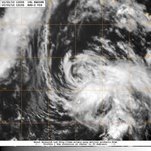
Sheared now but still hangin' on. Actually looks pretty good for an old lady. 
0 likes

I seriously am beginnig to think that Nadine may take the cake for longest-lived (including San Ciricao). 
0 likes
Personal Forecast Disclaimer:
The posts in this forum are NOT official forecast and should not be used as such. They are just the opinion of the poster and may or may not be backed by sound meteorological data. They are NOT endorsed by any professional institution or storm2k.org.
Hope this helped
The posts in this forum are NOT official forecast and should not be used as such. They are just the opinion of the poster and may or may not be backed by sound meteorological data. They are NOT endorsed by any professional institution or storm2k.org.
Hope this helped

Re:
greenkat wrote:I seriously am beginnig to think that Nadine may take the cake for longest-lived (including San Ciricao).
Nah, she would have to stick around for several more days to take that record and I think she's starting to say her goodbyes.
0 likes
-
WeatherGuesser
- Category 5

- Posts: 2672
- Joined: Tue Jun 29, 2010 6:46 am
Re: Re:
Buck wrote:greenkat wrote:I seriously am beginnig to think that Nadine may take the cake for longest-lived (including San Ciricao).
Nah, she would have to stick around for several more days to take that record and I think she's starting to say her goodbyes.
At this point, I'm rooting for Nae-Nae to hang around long enough to make her mark in the records.
0 likes
-
cycloneye
- Admin
- Posts: 149276
- Age: 69
- Joined: Thu Oct 10, 2002 10:54 am
- Location: San Juan, Puerto Rico
Re: ATL: NADINE - Tropical Storm - Discussion
BULLETIN
TROPICAL STORM NADINE ADVISORY NUMBER 85
NWS NATIONAL HURRICANE CENTER MIAMI FL AL142012
500 PM AST WED OCT 03 2012
...NADINE FORECAST TO WEAKEN BUT STILL EXPECTED TO BRING TROPICAL
STORM OR GALE CONDITIONS TO THE AZORES TONIGHT OR EARLY THURSDAY...
SUMMARY OF 500 PM AST...2100 UTC...INFORMATION
----------------------------------------------
LOCATION...36.1N 31.9W
ABOUT 300 MI...485 KM WSW OF THE AZORES
MAXIMUM SUSTAINED WINDS...45 MPH...75 KM/H
PRESENT MOVEMENT...NE OR 45 DEGREES AT 18 MPH...30 KM/H
MINIMUM CENTRAL PRESSURE...1002 MB...29.59 INCHES
0 likes
Visit the Caribbean-Central America Weather Thread where you can find at first post web cams,radars
and observations from Caribbean basin members Click Here
and observations from Caribbean basin members Click Here
-
brunota2003
- S2K Supporter
- Posts: 9476
- Age: 35
- Joined: Sat Jul 30, 2005 9:56 pm
- Location: Stanton, KY...formerly Havelock, NC
- Contact:
I would actually love for Nadine to revolve all the way around the extratropical low and eject back down into warmer waters. Especially if it then redeveloped into a TC, talk about a heck of a post-season track! Too bad that's not gonna happen  that low is going to eat Nadine for lunch
0 likes
Just a small town southern boy helping other humans.
-
TropicalAnalystwx13

- Category 5
- Posts: 2109
- Age: 28
- Joined: Tue Jul 19, 2011 8:20 pm
- Location: Wilmington, NC
- Contact:
I think it is time we say goodbye to the never-ending Nadine. Convection has been non-existent atop the low-level center for nearly 12 hours now, and there are no signs that it will rebuild anytime soon. If the 03z advisory is indeed Nadine's final, the storm would have lasted 20.75 days, fifth in the record books for the longest time spent as a tropical cyclone, reached a maximum intensity of 90 mph/978 millibars, and accumulated an ACE index of ~26 units, a quarter of the total ACE during the entire season.
0 likes
-
galaxy401

- Category 5
- Posts: 2446
- Age: 30
- Joined: Sat Aug 25, 2012 9:04 pm
- Location: Casa Grande, Arizona
Does the best track show Nadine as post-tropical or still tropical?
Looking at the loops, it appears Nadine is about to get absorbed by the front according to my amateur eyes.
Looking at the loops, it appears Nadine is about to get absorbed by the front according to my amateur eyes.
Last edited by galaxy401 on Wed Oct 03, 2012 9:09 pm, edited 1 time in total.
0 likes
Got my eyes on moving right into Hurricane Alley: Florida.
-
cycloneye
- Admin
- Posts: 149276
- Age: 69
- Joined: Thu Oct 10, 2002 10:54 am
- Location: San Juan, Puerto Rico
Re:
galaxy401 wrote:Does the best track show Nadine as post-tropical or still tropical?
Still as TS Nadine at 40kts.
http://ftp.nhc.noaa.gov/atcf/tcweb/inve ... 012.invest
0 likes
Visit the Caribbean-Central America Weather Thread where you can find at first post web cams,radars
and observations from Caribbean basin members Click Here
and observations from Caribbean basin members Click Here
-
cycloneye
- Admin
- Posts: 149276
- Age: 69
- Joined: Thu Oct 10, 2002 10:54 am
- Location: San Juan, Puerto Rico
Re: ATL: NADINE - Tropical Storm - Discussion
BULLETIN
TROPICAL STORM NADINE INTERMEDIATE ADVISORY NUMBER 87A
NWS NATIONAL HURRICANE CENTER MIAMI FL AL142012
800 AM AST THU OCT 04 2012
...NADINE BECOMING ASSOCIATED WITH A COLD FRONT...
SUMMARY OF 800 AM AST...1200 UTC...INFORMATION
----------------------------------------------
LOCATION...39.0N 27.2W
ABOUT 20 MI...30 KM NNW OF LAJES IN THE AZORES
MAXIMUM SUSTAINED WINDS...45 MPH...75 KM/H
PRESENT MOVEMENT...NE OR 40 DEGREES AT 23 MPH...37 KM/H
MINIMUM CENTRAL PRESSURE...992 MB...29.29 INCHES
It has been a very extraordinary system to follow from start to the end that will occur in a few hours with the many twist and turns that she made during the very long journey.
0 likes
Visit the Caribbean-Central America Weather Thread where you can find at first post web cams,radars
and observations from Caribbean basin members Click Here
and observations from Caribbean basin members Click Here
-
WeatherGuesser
- Category 5
- Posts: 2672
- Joined: Tue Jun 29, 2010 6:46 am
500 AM AST THU OCT 04 2012
NADINE IS LOSING ITS TROPICAL CHARACTERISTICS THIS MORNING. THERE
IS NO CONVECTION NEAR THE CENTER...AND WHAT CONVECTION REMAINS IS
IN A BAND WELL TO THE NORTHEAST OF THE CENTER. IN ADDITION...A
COLD FRONT IS APPROACHING THE STORM FROM THE WEST.
8:00 AM AST Thu Oct 4
Location: 39.0°N 27.2°W
Moving: NE at 23 mph
Min pressure: 992 mb
Max sustained: 45 mph
Public Advisory #87A
0 likes
-
Nate-Gillson
- Tropical Storm

- Posts: 133
- Age: 40
- Joined: Sun Aug 22, 2004 8:27 pm
- Location: Cedar Rapids, Iowa
-
wxman57

- Moderator-Pro Met

- Posts: 23172
- Age: 68
- Joined: Sat Jun 21, 2003 8:06 pm
- Location: Houston, TX (southwest)
Re: ATL: NADINE - Tropical Storm - Discussion
Bones has been waiting for this moment for quite a while:

0 likes
-
HenkL
- S2K Supporter
- Posts: 2401
- Joined: Fri Sep 10, 2004 5:33 pm
- Location: Groningen, The Netherlands
- Contact:
Best track 12Z:
AL, 14, 2012100412, , BEST, 0, 390N, 272W, 40, 998, DB
ftp://ftp.nhc.noaa.gov/atcf/tcweb/inves ... 012.invest
AL, 14, 2012100412, , BEST, 0, 390N, 272W, 40, 998, DB
ftp://ftp.nhc.noaa.gov/atcf/tcweb/inves ... 012.invest
0 likes
Who is online
Users browsing this forum: No registered users and 27 guests