Remains at 50%.
SHOWER AND THUNDERSTORM ACTIVITY HAS CHANGED LITTLE OVER THE PAST
FEW HOURS IN ASSOCIATION WITH A SMALL AREA OF LOW PRESSURE LOCATED
ABOUT 250 MILES NORTHEAST OF THE CENTRAL BAHAMAS. THERE IS STILL A
SMALL WINDOW OF OPPORTUNITY FOR A TROPICAL DEPRESSION TO FORM
BEFORE THE LOW MERGES WITH A COLD FRONT LATER TODAY. THIS SYSTEM
HAS A MEDIUM CHANCE...50 PERCENT...OF BECOMING A TROPICAL CYCLONE
DURING THE NEXT 48 HOURS AS IT MOVES SLOWLY SOUTHWARD. ADDITIONAL
INFORMATION ON THIS DISTURBANCE CAN BE FOUND IN HIGH SEAS FORECASTS
ISSUED BY THE NATIONAL WATHER SERVICE
ATL: PATTY - Remnants - Discussion
Moderator: S2k Moderators
-
cycloneye

- Admin

- Posts: 149276
- Age: 69
- Joined: Thu Oct 10, 2002 10:54 am
- Location: San Juan, Puerto Rico
Re: ATL: INVEST 97L - Discussion
0 likes
Visit the Caribbean-Central America Weather Thread where you can find at first post web cams,radars
and observations from Caribbean basin members Click Here
and observations from Caribbean basin members Click Here

-
cycloneye
- Admin
- Posts: 149276
- Age: 69
- Joined: Thu Oct 10, 2002 10:54 am
- Location: San Juan, Puerto Rico
Re: ATL: INVEST 97L - Discussion
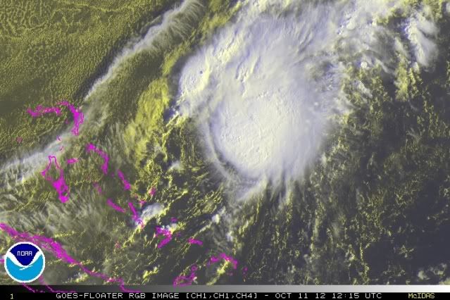
Hey peeps,look at SSD Dvorak 
11/1145 UTC 25.6N 72.6W T3.0/3.0 97L -- Atlantic
11/1145 UTC 25.6N 72.6W T3.0/3.0 97L -- Atlantic
0 likes
Visit the Caribbean-Central America Weather Thread where you can find at first post web cams,radars
and observations from Caribbean basin members Click Here
and observations from Caribbean basin members Click Here

-
Chickenzilla
- Tropical Storm

- Posts: 109
- Joined: Wed Oct 19, 2011 7:31 am
- Location: Croatia (Southeast Europe)
Re:
NDG wrote:What are they waiting to upgrade 97L to a TD?
Maybe NHC doesn't want a system that will last very little.
0 likes
-
ozonepete
- Professional-Met

- Posts: 4743
- Joined: Mon Sep 07, 2009 3:23 pm
- Location: From Ozone Park, NYC / Now in Brooklyn, NY
Re: ATL: INVEST 97L - Discussion
cycloneye wrote:Hey peeps,look at SSD Dvorak
11/1145 UTC 25.6N 72.6W T3.0/3.0 97L -- Atlantic
0 likes
-
ozonepete
- Professional-Met
- Posts: 4743
- Joined: Mon Sep 07, 2009 3:23 pm
- Location: From Ozone Park, NYC / Now in Brooklyn, NY
Re: ATL: INVEST 97L - Discussion
When would renumber have to come up for this to make depression at 11?
0 likes
-
cycloneye
- Admin
- Posts: 149276
- Age: 69
- Joined: Thu Oct 10, 2002 10:54 am
- Location: San Juan, Puerto Rico
Re: ATL: INVEST 97L - Discussion
ozonepete wrote:When would renumber have to come up for this to make depression at 11?
Watch the renumber section before 10:30 AM EDT on the atcf site to see if they add a second 97L renumber as there is one that was renumbered on 28 of August.
http://ftp.nhc.noaa.gov/atcf/tcweb/
0 likes
Visit the Caribbean-Central America Weather Thread where you can find at first post web cams,radars
and observations from Caribbean basin members Click Here
and observations from Caribbean basin members Click Here
-
tolakram
- Admin
- Posts: 20179
- Age: 62
- Joined: Sun Aug 27, 2006 8:23 pm
- Location: Florence, KY (name is Mark)
Re: ATL: INVEST 97L - Discussion
Last system we had people exclaiming it should not be upgraded, now everyone wants an upgrade. Let's be sure and stay respectful please. 
Live loop (horrible at the moment): http://wwwghcc.msfc.nasa.gov/cgi-bin/ge ... umframes=5
Live loop (horrible at the moment): http://wwwghcc.msfc.nasa.gov/cgi-bin/ge ... umframes=5
0 likes
M a r k
- - - - -
Join us in chat: Storm2K Chatroom Invite. Android and IOS apps also available.
The posts in this forum are NOT official forecasts and should not be used as such. Posts are NOT endorsed by any professional institution or STORM2K.org. For official information and forecasts, please refer to NHC and NWS products.
-
tolakram
- Admin
- Posts: 20179
- Age: 62
- Joined: Sun Aug 27, 2006 8:23 pm
- Location: Florence, KY (name is Mark)
Re: ATL: INVEST 97L - Discussion
Personal Forecast Disclaimer:
The posts in this forum are NOT official forecast and should not be used as such. They are just the opinion of the poster and may or may not be backed by sound meteorological data. They are NOT endorsed by any professional institution or storm2k.org. For official information, please refer to the NHC and NWS products.
If you play the 30 frame visible loop: http://wwwghcc.msfc.nasa.gov/cgi-bin/ge ... mframes=30
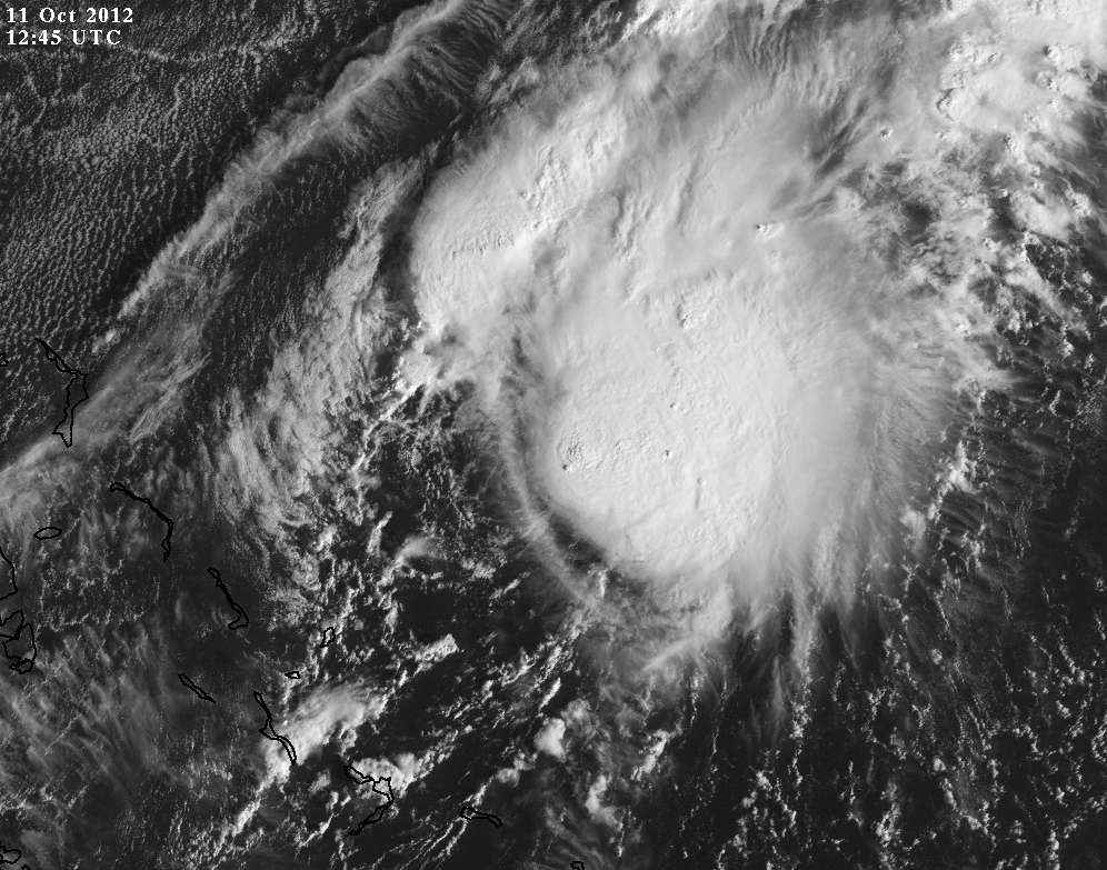
Yesterday the LLC was ill defined and convection not concentrated over any center. Obviously it's much better defined today but TD declaration requires persistence. I would guess an upgrade at 5PM unless upper level winds blow it apart by then. I believe they use mostly objective measures and obviously one of them has not met the requirement for TD declaration yet.
The posts in this forum are NOT official forecast and should not be used as such. They are just the opinion of the poster and may or may not be backed by sound meteorological data. They are NOT endorsed by any professional institution or storm2k.org. For official information, please refer to the NHC and NWS products.
If you play the 30 frame visible loop: http://wwwghcc.msfc.nasa.gov/cgi-bin/ge ... mframes=30
Yesterday the LLC was ill defined and convection not concentrated over any center. Obviously it's much better defined today but TD declaration requires persistence. I would guess an upgrade at 5PM unless upper level winds blow it apart by then. I believe they use mostly objective measures and obviously one of them has not met the requirement for TD declaration yet.
0 likes
M a r k
- - - - -
Join us in chat: Storm2K Chatroom Invite. Android and IOS apps also available.
The posts in this forum are NOT official forecasts and should not be used as such. Posts are NOT endorsed by any professional institution or STORM2K.org. For official information and forecasts, please refer to NHC and NWS products.
- - - - -
Join us in chat: Storm2K Chatroom Invite. Android and IOS apps also available.
The posts in this forum are NOT official forecasts and should not be used as such. Posts are NOT endorsed by any professional institution or STORM2K.org. For official information and forecasts, please refer to NHC and NWS products.
-
ozonepete
- Professional-Met
- Posts: 4743
- Joined: Mon Sep 07, 2009 3:23 pm
- Location: From Ozone Park, NYC / Now in Brooklyn, NY
Re: ATL: INVEST 97L - Discussion
cycloneye wrote:ozonepete wrote:When would renumber have to come up for this to make depression at 11?
Watch the renumber section before 10:30 AM EDT on the atcf site to see if they add a second 97L renumber as there is one that was renumbered on 28 of August.
http://ftp.nhc.noaa.gov/atcf/tcweb/
Thanks, Luis. I've never gone on there much so I appreciate it. I see you can also click on the column header "Last modified" and it sorts by date from oldest to newest. If you click on it again it sorts from newest to oldest, so then you can just watch the top of the column for the new renumber file to pop up (I would think.)
0 likes
-
cycloneye
- Admin
- Posts: 149276
- Age: 69
- Joined: Thu Oct 10, 2002 10:54 am
- Location: San Juan, Puerto Rico
Re: ATL: INVEST 97L - Discussion
BEGIN
NHC_ATCF
invest_RENUMBER_al972012_al162012.ren
FSTDA
R
U
040
010
0000
201210111414
NONE
NOTIFY=ATRP
NHC_ATCF
invest_RENUMBER_al972012_al162012.ren
FSTDA
R
U
040
010
0000
201210111414
NONE
NOTIFY=ATRP
0 likes
Visit the Caribbean-Central America Weather Thread where you can find at first post web cams,radars
and observations from Caribbean basin members Click Here
and observations from Caribbean basin members Click Here
-
cycloneye
- Admin
- Posts: 149276
- Age: 69
- Joined: Thu Oct 10, 2002 10:54 am
- Location: San Juan, Puerto Rico
Re: ATL: INVEST 97L - Discussion
AL, 16, 2012101112, , BEST, 0, 255N, 726W, 30, 1009, TD
0 likes
Visit the Caribbean-Central America Weather Thread where you can find at first post web cams,radars
and observations from Caribbean basin members Click Here
and observations from Caribbean basin members Click Here
-
tolakram
- Admin
- Posts: 20179
- Age: 62
- Joined: Sun Aug 27, 2006 8:23 pm
- Location: Florence, KY (name is Mark)
Re: ATL: INVEST 97L - Discussion
ozonepete wrote:cycloneye wrote:ozonepete wrote:When would renumber have to come up for this to make depression at 11?
Watch the renumber section before 10:30 AM EDT on the atcf site to see if they add a second 97L renumber as there is one that was renumbered on 28 of August.
http://ftp.nhc.noaa.gov/atcf/tcweb/
Thanks, Luis. I've never gone on there much so I appreciate it. I see you can also click on the column header "Last modified" and it sorts by date from oldest to newest. If you click on it again it sorts from newest to oldest, so then you can just watch the top of the column for the new renumber file to pop up (I would think.)
I've learned not to try and beat Luis to the renumber if he's watching. Refresh burns me every time. You can sort the list, but apparently that does not check for any updates. The other clue to the renumber is when I post a guess, since I'm almost always wrong.
0 likes
M a r k
- - - - -
Join us in chat: Storm2K Chatroom Invite. Android and IOS apps also available.
The posts in this forum are NOT official forecasts and should not be used as such. Posts are NOT endorsed by any professional institution or STORM2K.org. For official information and forecasts, please refer to NHC and NWS products.
- - - - -
Join us in chat: Storm2K Chatroom Invite. Android and IOS apps also available.
The posts in this forum are NOT official forecasts and should not be used as such. Posts are NOT endorsed by any professional institution or STORM2K.org. For official information and forecasts, please refer to NHC and NWS products.
-
tolakram
- Admin
- Posts: 20179
- Age: 62
- Joined: Sun Aug 27, 2006 8:23 pm
- Location: Florence, KY (name is Mark)
Re: ATL: INVEST 97L - Discussion
Latest
0 likes
M a r k
- - - - -
Join us in chat: Storm2K Chatroom Invite. Android and IOS apps also available.
The posts in this forum are NOT official forecasts and should not be used as such. Posts are NOT endorsed by any professional institution or STORM2K.org. For official information and forecasts, please refer to NHC and NWS products.
- - - - -
Join us in chat: Storm2K Chatroom Invite. Android and IOS apps also available.
The posts in this forum are NOT official forecasts and should not be used as such. Posts are NOT endorsed by any professional institution or STORM2K.org. For official information and forecasts, please refer to NHC and NWS products.
-
ozonepete
- Professional-Met
- Posts: 4743
- Joined: Mon Sep 07, 2009 3:23 pm
- Location: From Ozone Park, NYC / Now in Brooklyn, NY
Re: ATL: INVEST 97L - Discussion
Yup - looks quite good to me. The LLC is tucked under that convective burst on the western side. I'm pretty sure this will make TS today. Remember it went from 20% to a TD in 12 hours and it just has no negatives for another 24 hours.
Hey Mark, yeah I thought I caught the renumber before Luis and he already had it up here! lol...
Hey Mark, yeah I thought I caught the renumber before Luis and he already had it up here! lol...
0 likes
-
cycloneye
- Admin
- Posts: 149276
- Age: 69
- Joined: Thu Oct 10, 2002 10:54 am
- Location: San Juan, Puerto Rico
Re: ATL: SIXTEEN - Tropical Depression - Discussion
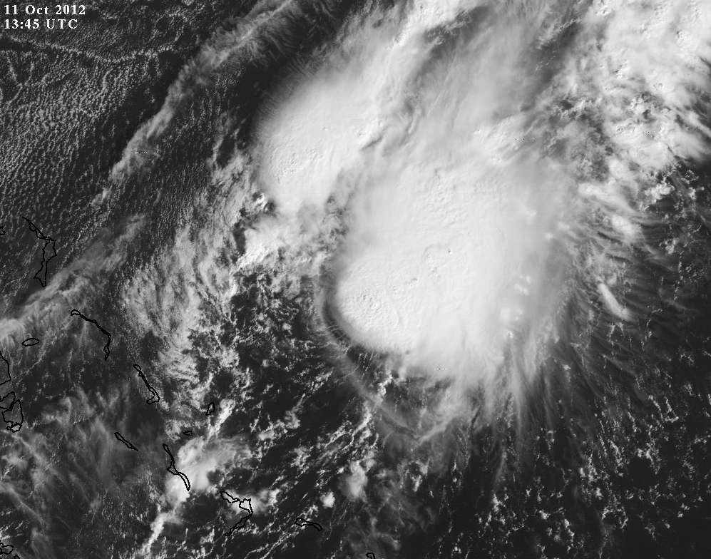
BULLETIN
TROPICAL DEPRESSION SIXTEEN ADVISORY NUMBER 1
NWS NATIONAL HURRICANE CENTER MIAMI FL AL162012
1100 AM EDT THU OCT 11 2012
...TROPICAL DEPRESSION FORMS EAST-NORTHEAST OF THE CENTRAL
BAHAMAS...
SUMMARY OF 1100 AM EDT...1500 UTC...INFORMATION
-----------------------------------------------
LOCATION...25.4N 72.6W
ABOUT 235 MI...380 KM ENE OF THE CENTRAL BAHAMAS
MAXIMUM SUSTAINED WINDS...35 MPH...55 KM/H
PRESENT MOVEMENT...S OR 180 DEGREES AT 1 MPH...2 KM/H
MINIMUM CENTRAL PRESSURE...1009 MB...29.80 INCHES
0 likes
Visit the Caribbean-Central America Weather Thread where you can find at first post web cams,radars
and observations from Caribbean basin members Click Here
and observations from Caribbean basin members Click Here
-
MGC

- S2K Supporter

- Posts: 5940
- Joined: Sun Mar 23, 2003 9:05 pm
- Location: Pass Christian MS, or what is left.
Re: ATL: SIXTEEN - Tropical Depression - Discussion
Looks like a TD to me.....and this was given up for dead yesterday....MGC
0 likes
-
Weatherguy173

- Tropical Storm
- Posts: 148
- Age: 32
- Joined: Wed Aug 01, 2012 10:55 pm
- Location: Short Hills NJ
Re: ATL: SIXTEEN - Tropical Depression - Discussion
you knew sooner or later they would dub this thing a TD.
0 likes
Nothing I say is intended to be a forecast; it's only food for thought and friendly advice!
Who is online
Users browsing this forum: Google Adsense [Bot] and 104 guests