ATL: SANDY - Remnants - Discussion

Moderator: S2k Moderators

Message
Author
bzukajo
Tropical Storm
Tropical Storm
Posts: 101
Joined: Mon Sep 15, 2003 7:17 pm
Location: MA
Contact:

Re: ATL: SANDY - Hurricane - Discussion

#581 Postby bzukajo » Wed Oct 24, 2012 2:28 pm

So, looking at everything, what kind of surge are we talking about around the NYC area? I know the subways become vulnerable at some point, along with a good chunk of the city. Do I need to find the "It Could Happen Tomorrow" episode? Of course, this isn't to downplay the threats elsewhere...but if this looks to happen, being a week out, I would imagine any evacuations would have to start within the next few days?


I am curious about this too. Irene had a significant storm surge in Long Island Sound. The eastern part of the golf course in Rye was completely under seawater. It went right up to the house next to my father's. I am not sure how many feet that was vertically, but it had to be at least 5 feet or more. I hope this does not have a surge potential larger than that.
0 likes   

User avatar
SFLcane
S2K Supporter
S2K Supporter
Posts: 10163
Age: 47
Joined: Sat Jun 05, 2010 1:44 pm
Location: Lake Worth Florida

Re: ATL: SANDY - Hurricane - Discussion

#582 Postby SFLcane » Wed Oct 24, 2012 2:30 pm

TS Watch area..

ATLANTIC COASTAL WATERS FROM JUPITER INLET TO OCEAN REEF OUT TO 60
NM AND GULF COASTAL WATERS FROM EAST CAPE SABLE TO CHOKOLOSKEE OUT
20 NM AND CHOKOLOSKEE TO BONITA BEACH OUT 60 NM...INCLUDING THE
WATERS OF BISCAYNE BAY AND LAKE OKEECHOBEE.
0 likes   

crimi481
Category 2
Category 2
Posts: 602
Joined: Thu Sep 09, 2004 4:47 pm

Re: ATL: SANDY - Hurricane - Discussion

#583 Postby crimi481 » Wed Oct 24, 2012 2:31 pm

Blown Away wrote:
crimi481 wrote:I am no Pro -but just watching loop - seems like ridging to Sandy's North, wants to push her more West?
Effects of diving Trough wouln't come into play for few days yet?
http://www.ssec.wisc.edu/data/geo/index ... thod=flash


I love to wobble watch and IMO Sandy is on track to be slightly left of the next forecast point.


I wobble quite often - as time goes by
0 likes   

User avatar
SFLcane
S2K Supporter
S2K Supporter
Posts: 10163
Age: 47
Joined: Sat Jun 05, 2010 1:44 pm
Location: Lake Worth Florida

Re: ATL: SANDY - Hurricane - Discussion

#584 Postby SFLcane » Wed Oct 24, 2012 2:32 pm

0 likes   

justinggibbs
Tropical Wave
Tropical Wave
Posts: 7
Joined: Fri Oct 12, 2012 3:56 pm
Location: Brownsville, TX

#585 Postby justinggibbs » Wed Oct 24, 2012 2:38 pm

http://www.nws.noaa.gov/view/validProds ... &node=kwno

4 a day Radiosondes for the entire CONUS starting tomorrow.
0 likes   
This post is NOT AN OFFICIAL FORECAST and should not be used as such. It is just the opinion of the poster and may or may not be backed by sound meteorological data. It is NOT endorsed by any professional institution including storm2k.org. For Official Information please refer to the NHC and NWS products. Opinions my own and not those of my employer.

ozonepete
Professional-Met
Professional-Met
Posts: 4743
Joined: Mon Sep 07, 2009 3:23 pm
Location: From Ozone Park, NYC / Now in Brooklyn, NY

Re:

#586 Postby ozonepete » Wed Oct 24, 2012 2:38 pm

brunota2003 wrote:So, looking at everything, what kind of surge are we talking about around the NYC area? I know the subways become vulnerable at some point, along with a good chunk of the city. Do I need to find the "It Could Happen Tomorrow" episode? Of course, this isn't to downplay the threats elsewhere...but if this looks to happen, being a week out, I would imagine any evacuations would have to start within the next few days?


It's a massive operation to run when a hurricane (or equivalent hybrid nor'easter) threatens. I know that the NYC Office of Emergency Management has a conference call this afternoon at 4PM for all NYC officers. This will be a first briefing. This could be the first cancelled school day for a hurricane since Hurricane Gloria in 1985 since Irene from two years ago was on a Sunday. Evacuations have to be styarted 48 hours ahead of time for the lowest lying areas.
0 likes   

michaelder
Tropical Low
Tropical Low
Posts: 12
Joined: Tue Aug 31, 2004 8:41 pm
Location: Jensen Beach, Florida

Re: ATL: SANDY - Hurricane - Discussion

#587 Postby michaelder » Wed Oct 24, 2012 2:40 pm

Copied from Weather Underground for Norman Manley Airport on peninsula south of Kingston Jamaica at 3:30 EDT

Kingston Weather at a Glance
Weather Station
Kingston / Norman Manley
Elevation
10 ft

Now
Heavy Rain
Temperature
80 °F
Feels Like 80 °F
Wind(mph)
116

Wind 116 has to be in error?
0 likes   

User avatar
artist
Category 5
Category 5
Posts: 9792
Joined: Mon Jun 06, 2005 3:26 pm
Location: West Palm

Re: ATL: SANDY - Hurricane - Discussion

#588 Postby artist » Wed Oct 24, 2012 2:45 pm

michaelder wrote:Copied from Weather Underground for Norman Manley Airport on peninsula south of Kingston Jamaica at 3:30 EDT

Kingston Weather at a Glance
Weather Station
Kingston / Norman Manley
Elevation
10 ft

Now
Heavy Rain
Temperature
80 °F
Feels Like 80 °F
Wind(mph)
116

Wind 116 has to be in error?

I sure hope so, though I guess I gust could have come in at that.
0 likes   

OuterBanker
S2K Supporter
S2K Supporter
Posts: 1731
Joined: Wed Feb 26, 2003 10:53 am
Location: Nags Head, NC
Contact:

Re: ATL: SANDY - Hurricane - Discussion

#589 Postby OuterBanker » Wed Oct 24, 2012 2:48 pm

Probably kph (kilometers per hour)
0 likes   

User avatar
CourierPR
Category 5
Category 5
Posts: 1335
Age: 71
Joined: Tue Aug 31, 2004 7:53 pm
Location: Pompano Beach, Florida

Re: ATL: SANDY - Hurricane - Discussion

#590 Postby CourierPR » Wed Oct 24, 2012 2:50 pm

OuterBanker wrote:Probably kph (kilometers per hour)


I think that's about 70 mph.
0 likes   

OuterBanker
S2K Supporter
S2K Supporter
Posts: 1731
Joined: Wed Feb 26, 2003 10:53 am
Location: Nags Head, NC
Contact:

Re: ATL: SANDY - Hurricane - Discussion

#591 Postby OuterBanker » Wed Oct 24, 2012 2:51 pm

Yep, 72 mph and change
0 likes   

User avatar
Tireman4
S2K Supporter
S2K Supporter
Posts: 5853
Age: 59
Joined: Fri Jun 30, 2006 1:08 pm
Location: Humble, Texas
Contact:

#592 Postby Tireman4 » Wed Oct 24, 2012 2:51 pm

Gotta be. (In KPH, that is)


The posts in this forum are NOT official forecast and should not be used as such. They are just the opinion of the poster and may or may not be backed by sound meteorological data. They are NOT endorsed by any professional institution or storm2k.org. For official information, please refer to the NHC and NWS products.
0 likes   

User avatar
cycloneye
Admin
Admin
Posts: 145327
Age: 68
Joined: Thu Oct 10, 2002 10:54 am
Location: San Juan, Puerto Rico

Re: ATL: SANDY - Hurricane - Discussion

#593 Postby cycloneye » Wed Oct 24, 2012 3:12 pm

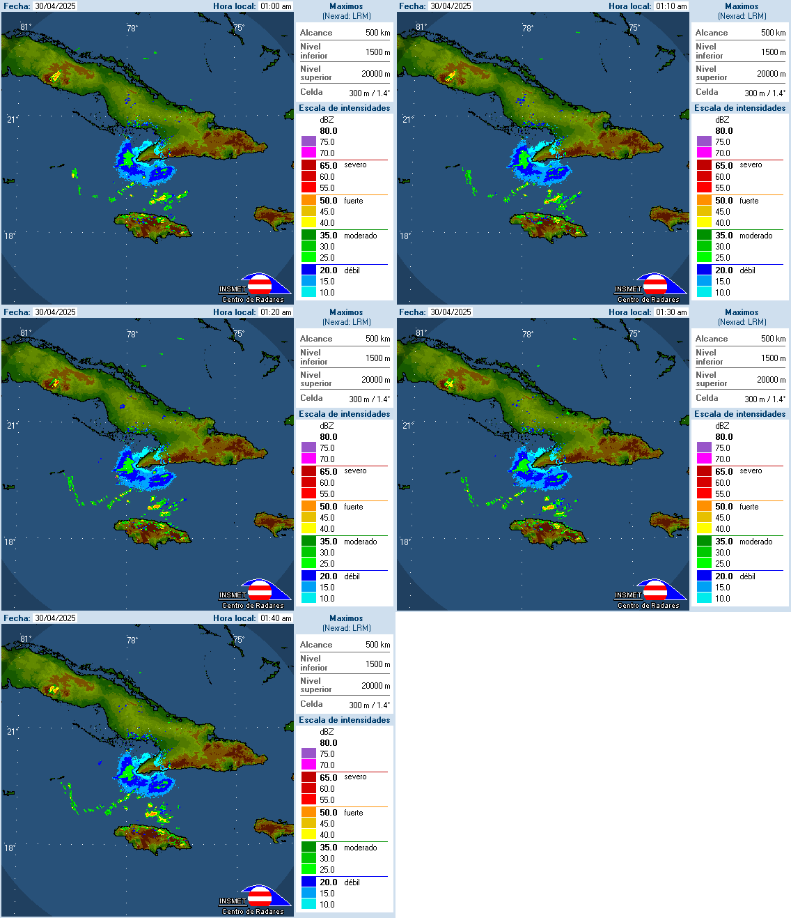
Eye emerging from Jamaica.

Image
0 likes   
Visit the Caribbean-Central America Weather Thread where you can find at first post web cams,radars
and observations from Caribbean basin members Click Here

hurricanekid416
Tropical Storm
Tropical Storm
Posts: 179
Joined: Wed Oct 24, 2012 2:43 pm

#594 Postby hurricanekid416 » Wed Oct 24, 2012 3:18 pm

Hey guys im new it may be hard to beleive but i am a 13 year old kid that loves to track hurricanes i wont be immature ive been watching this form for a while so with Sandy, i live in delaware and im worried because ive never really been through a hurricane if this storm were to hit here what would the effects be?
0 likes   

Sanibel
Category 5
Category 5
Posts: 10375
Joined: Mon Aug 30, 2004 11:06 pm
Location: Offshore SW Florida

Re: ATL: SANDY - Hurricane - Discussion

#595 Postby Sanibel » Wed Oct 24, 2012 3:26 pm

I don't think I've ever seen a south-north transiting hurricane through Jamaica.
0 likes   

User avatar
gatorcane
S2K Supporter
S2K Supporter
Posts: 23691
Age: 47
Joined: Sun Mar 13, 2005 3:54 pm
Location: Boca Raton, FL

#596 Postby gatorcane » Wed Oct 24, 2012 3:28 pm

Sandy is gradually expanding in size...as she becomes more hybrid as she passes through the Bahamas will be interesting if this west-weighted system prediction the globals are showing comes to fruition:

http://www.ssd.noaa.gov/goes/east/watl/loop-avn.html

Cloud deck from outflow penetrating into South Florida as ridging that has been keeping the clouds east of the state the past several days is breaking down over Florida and the Bahamas.
Last edited by gatorcane on Wed Oct 24, 2012 3:32 pm, edited 4 times in total.
0 likes   

User avatar
Weatherguy173
Tropical Storm
Tropical Storm
Posts: 148
Age: 31
Joined: Wed Aug 01, 2012 10:55 pm
Location: Short Hills NJ

Re: ATL: SANDY - Hurricane - Discussion

#597 Postby Weatherguy173 » Wed Oct 24, 2012 3:28 pm

Sanibel wrote:I don't think I've ever seen a south-north transiting hurricane through Jamaica.


and then goes east to west possibly later on... - this thing could have one freaky path :eek:
0 likes   
Nothing I say is intended to be a forecast; it's only food for thought and friendly advice!

jaxfladude
Category 5
Category 5
Posts: 1249
Joined: Wed Aug 24, 2005 9:36 pm
Location: Jacksonville, Fla

#598 Postby jaxfladude » Wed Oct 24, 2012 3:29 pm

Just how long was Sandy over Jamaica, did it really clear the island already or still on land?
0 likes   
Stay safe y'all

User avatar
Evil Jeremy
S2K Supporter
S2K Supporter
Posts: 5463
Age: 32
Joined: Mon Apr 10, 2006 2:10 pm
Location: Los Angeles, CA

#599 Postby Evil Jeremy » Wed Oct 24, 2012 3:31 pm

New advisory within 30 minutes. How big of a change do you think the NHC will make in the track? Short term, they will likely move it closer to Florida a bit, as nearly all the models have moved west in 2-3 days. And I think TS warnings for most of the watch area.
0 likes   
Frances 04 / Jeanne 04 / Katrina 05 / Wilma 05 / Fay 08 / Debby 12 / Andrea 13 / Colin 16 / Hermine 16 / Matthew 16 / Irma 17

User avatar
cycloneye
Admin
Admin
Posts: 145327
Age: 68
Joined: Thu Oct 10, 2002 10:54 am
Location: San Juan, Puerto Rico

Re:

#600 Postby cycloneye » Wed Oct 24, 2012 3:31 pm

jaxfladude wrote:Just how long was Sandy over Jamaica, did it really clear the island already or still on land?


It made landfall around 3 PM EDT and an hour and a half later the complete eye is almost at the water.
0 likes   
Visit the Caribbean-Central America Weather Thread where you can find at first post web cams,radars
and observations from Caribbean basin members Click Here


Return to “2012”

Who is online

Users browsing this forum: No registered users and 6 guests