
ATL: SANDY - Remnants - Discussion
Moderator: S2k Moderators
-
TropicalAnalystwx13

- Category 5

- Posts: 2109
- Age: 28
- Joined: Tue Jul 19, 2011 8:20 pm
- Location: Wilmington, NC
- Contact:
This is not the appearance of a Category 1 hurricane. Based on satellite appearance alone, Sandy is probably a Category 2. And an intensifying one at that.
Last edited by TropicalAnalystwx13 on Wed Oct 24, 2012 5:14 pm, edited 1 time in total.
0 likes
-
Bocadude85

- Category 5
- Posts: 2991
- Age: 39
- Joined: Mon Apr 18, 2005 2:20 pm
- Location: Honolulu,Hi
Re: ATL: SANDY - Hurricane - Discussion
HurricaneFrances04 wrote:I'm surprised there are no inland warnings for Dade, Broward, and Palm Beach counties.
I do not understand this either considering Inland Martin county to our north is under a TS warning and so is Lake Okeechobee
0 likes
-
cycloneye

- Admin

- Posts: 149493
- Age: 69
- Joined: Thu Oct 10, 2002 10:54 am
- Location: San Juan, Puerto Rico
Re:
TropicalAnalystwx13 wrote:This is not the appearance of a Category 1 hurricane. Based on satellite appearance alone, Sandy is probably a Category 2. And an intensifying one at that.
http://weather.msfc.nasa.gov/GOES/GOES21482012298xBtlXl.jpg
The plane will tell the real story about how strong Sandy is.
0 likes
Visit the Caribbean-Central America Weather Thread where you can find at first post web cams,radars
and observations from Caribbean basin members Click Here
and observations from Caribbean basin members Click Here
-
JamesCaneTracker
- Tropical Storm

- Posts: 207
- Joined: Fri Jun 22, 2012 1:33 pm
- Location: Portland, Maine
Re:
TropicalAnalystwx13 wrote:This is not the appearance of a Category 1 hurricane. Based on satellite appearance alone, Sandy is probably a Category 2. And an intensifying one at that.
http://weather.msfc.nasa.gov/GOES/GOES21482012298xBtlXl.jpg
Recon will soon be in the system to give us the latest information... Just sit tight! lol Most likely it's deepening at a fairly good clip now but we will soon find out!
0 likes
-
cycloneye
- Admin
- Posts: 149493
- Age: 69
- Joined: Thu Oct 10, 2002 10:54 am
- Location: San Juan, Puerto Rico
Re: ATL: SANDY - Hurricane - Discussion
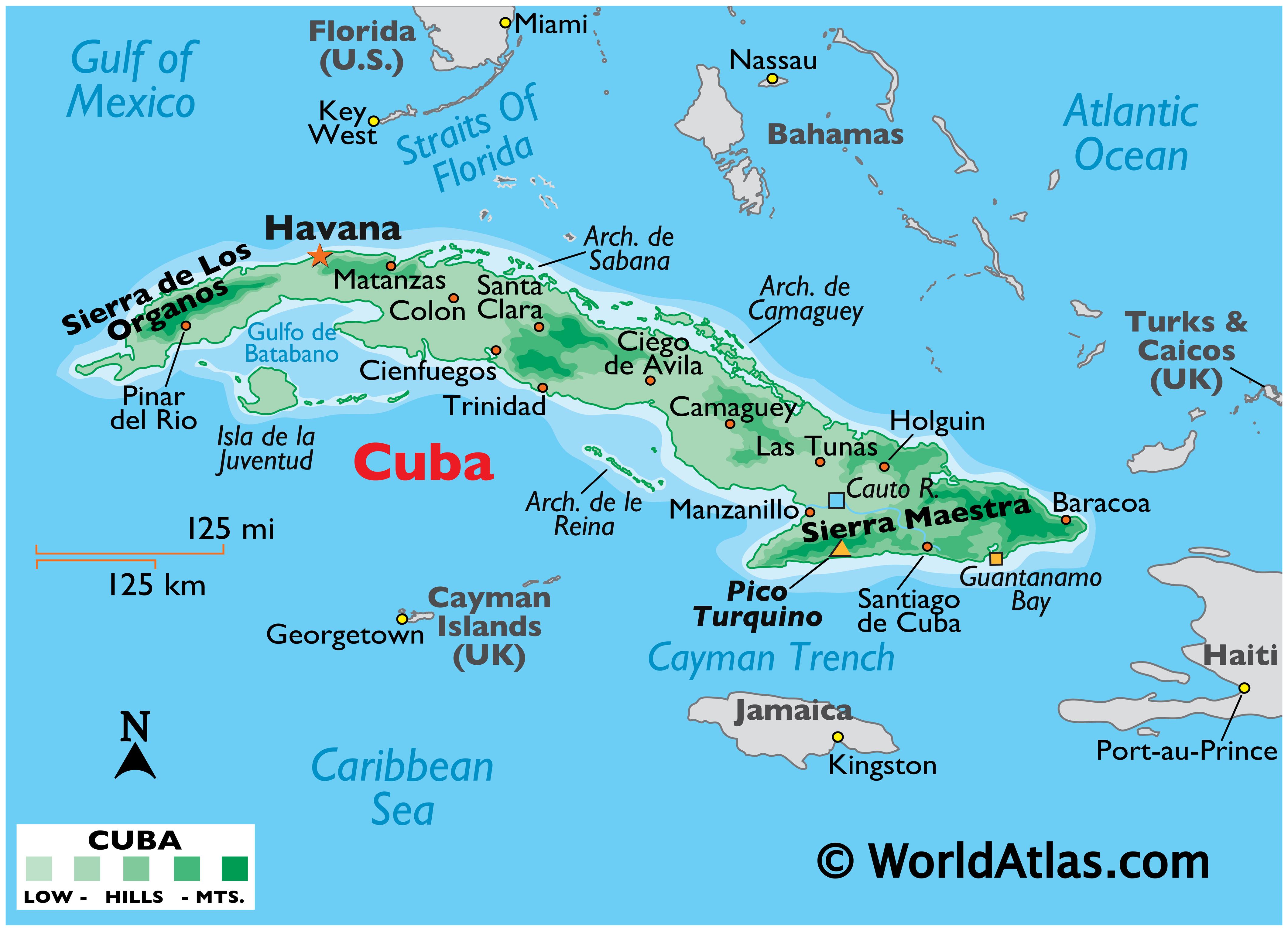
Topografy of Cuba. The Sierra Maestra with 6,000 foot mountains awaits,unless it avoids them.
0 likes
Visit the Caribbean-Central America Weather Thread where you can find at first post web cams,radars
and observations from Caribbean basin members Click Here
and observations from Caribbean basin members Click Here
-
thetraveler
- Tropical Depression

- Posts: 65
- Joined: Fri Sep 10, 2004 2:54 pm
- Location: Deep East Texas
Re: ATL: SANDY - Hurricane - Discussion
To my untrained eye, based on the above posted satelite image verses the radar loop posted on the previous page, it looks like she is moving more westerly than northerly. Does anyone else see that?
Personal Forecast Disclaimer:
The posts in this forum are NOT official forecast and should not be used as such. They are just the opinion of the poster and may or may not be backed by sound meteorological data. They are NOT endorsed by any professional institution or storm2k.org. For official information, please refer to the NHC and NWS products.
0 likes
-
ozonepete
- Professional-Met

- Posts: 4743
- Joined: Mon Sep 07, 2009 3:23 pm
- Location: From Ozone Park, NYC / Now in Brooklyn, NY
Re: ATL: SANDY - Hurricane - Discussion
cycloneye wrote:The most important lines of the 5 PM discussion.
WHILE THERE IS STILL QUITE A BIT OF EAST/WEST SPREAD IN THE GUIDANCE AT DAYS 4 AND 5...THE GFS HAS TRENDED OWARD THE SCENARIO THAT HAS BEEN SHOWN BY THE ECMWF OF MORE INTERACTION WITH THE TROUGH. WHILE THE GFS TRACK HAS SHIFTED WESTWARD AS A RESULT...THE ECMWF HAS ALSO SHIFTED WESTWARD THIS CYCLE. THE NHC FORECAST HAS BEEN ADJUSTED TO THE LEFT AS WELL...AND LIES ABOUT HALFWAY BETWEEN THE ECMWF AND THE GEFS ENSEMBLE MEAN AND THE FSU SUPER ENSEMBLE AT DAYS 3 THROUGH 5. THE UNCERTAINTY IN THE LONG-RANGE TRACK FORECAST REMAINS VERY HIGH...AND IT IS TOO EARLY TO DETERMINE SPECIFIC IMPACTS FOR THE U.S. EAST COAST NORTH OF FLORIDA.
Yes, Luis, this is starting to make a lot of people up here very nervous. They are still repairing damaged bridges and roads from Irene 2 years ago, especially in New York, New Jersey and New England, and this could be much worse. I'm especially concerned about the possibility of much higher water damage along the coastline. The projected path and the full moon on Monday are a worst case scenario for storm surge on top of astronomical high tides.
But we have to think about our Jamaica, Cuba, Bahama and Florida friends first. Good luck to everybody. Stay safe.
0 likes
-
TropicalAnalystwx13
- Category 5
- Posts: 2109
- Age: 28
- Joined: Tue Jul 19, 2011 8:20 pm
- Location: Wilmington, NC
- Contact:

-
ozonepete
- Professional-Met
- Posts: 4743
- Joined: Mon Sep 07, 2009 3:23 pm
- Location: From Ozone Park, NYC / Now in Brooklyn, NY
Re: ATL: SANDY - Hurricane - Discussion
thetraveler wrote:To my untrained eye, based on the above posted satelite image verses the radar loop posted on the previous page, it looks like she is moving more westerly than northerly. Does anyone else see that?
Personal Forecast Disclaimer:
The posts in this forum are NOT official forecast and should not be used as such. They are just the opinion of the poster and may or may not be backed by sound meteorological data. They are NOT endorsed by any professional institution or storm2k.org. For official information, please refer to the NHC and NWS products.
Aric talked about this earlier. Hurricanes often jog erratically as they make landfall and then correct their motion back to the expected track. But land interaction can definitely shift the track enough to affect the future path to some degree. I definitely see that it jogged a little west but it should resume northward motion soon. The slight NNW motion the NHC expects after it crosses Cuba will have to be watched really closely though.
0 likes
-
thetraveler
- Tropical Depression
- Posts: 65
- Joined: Fri Sep 10, 2004 2:54 pm
- Location: Deep East Texas
Re: ATL: SANDY - Hurricane - Discussion
ozonepete wrote:thetraveler wrote:To my untrained eye, based on the above posted satelite image verses the radar loop posted on the previous page, it looks like she is moving more westerly than northerly. Does anyone else see that?
Personal Forecast Disclaimer:
The posts in this forum are NOT official forecast and should not be used as such. They are just the opinion of the poster and may or may not be backed by sound meteorological data. They are NOT endorsed by any professional institution or storm2k.org. For official information, please refer to the NHC and NWS products.
Aric talked about this earlier. Hurricanes often jog erratically as they make landfall and then correct their motion back to the expected track. But land interaction can definitely shift the track enough to affect the future path to some degree. I definitely see that it jogged a little west but it should resume northward motion soon. The slight NNW motion the NHC expects after it crosses Cuba will have to be watched really closely though.
Thank you for your reply
0 likes

-
WeatherGuesser
- Category 5
- Posts: 2672
- Joined: Tue Jun 29, 2010 6:46 am
Re: ATL: SANDY - Hurricane - Discussion
ozonepete wrote:They are still repairing damaged bridges and roads from Irene 2 years ago,
I was thinking two years ago too, but the Wiki says August 2011.
http://en.wikipedia.org/wiki/Hurricane_Irene
0 likes
-
ozonepete
- Professional-Met
- Posts: 4743
- Joined: Mon Sep 07, 2009 3:23 pm
- Location: From Ozone Park, NYC / Now in Brooklyn, NY
Re: ATL: SANDY - Hurricane - Discussion
WeatherGuesser wrote:ozonepete wrote:They are still repairing damaged bridges and roads from Irene 2 years ago,
I was thinking two years ago too, but the Wiki says August 2011.
http://en.wikipedia.org/wiki/Hurricane_Irene
Thanks for the correction! I can't believe I thought 2 years had gone by. I guess I was hoping it had been. Boy, so people up here may only have gotten a year's break. Yeesh...
0 likes
-
WYNweather
- Tropical Depression
- Posts: 65
- Joined: Wed Jul 20, 2011 1:14 pm
-
Bocadude85
- Category 5
- Posts: 2991
- Age: 39
- Joined: Mon Apr 18, 2005 2:20 pm
- Location: Honolulu,Hi
Re:
HurrMark wrote:'Sandy' is now due south (and thus east) of the next forecast point. The further east it goes, the less Cuba it has to cross. Would be interested to see if that has an impact on the forecast.
Hurricanes do not move in a straight line. She wobbled NNW a few hours ago and is now wobbling NNE but if you smooth out the wobbles you will get a motion petty close to N. She appears to be right on the forecast track to me.
0 likes
-
TeamPlayersBlue

- Category 5
- Posts: 3531
- Joined: Tue Feb 02, 2010 1:44 am
- Location: Denver/Applewood, CO
Talked to family in Jamaica, everyone seems fine and no major damage to their house as of now. They have a very well built house in a nice neighborhood though but still good news
0 likes
Personal Forecast Disclaimer:
The posts in this forum are NOT official forecast and should not be used as such. They are just the opinion of the poster and may or may not be backed by sound meteorological data. They are NOT endorsed by any professional institution or storm2k.org. For official information, please refer to the NHC and NWS products.
The posts in this forum are NOT official forecast and should not be used as such. They are just the opinion of the poster and may or may not be backed by sound meteorological data. They are NOT endorsed by any professional institution or storm2k.org. For official information, please refer to the NHC and NWS products.
-
ozonepete
- Professional-Met
- Posts: 4743
- Joined: Mon Sep 07, 2009 3:23 pm
- Location: From Ozone Park, NYC / Now in Brooklyn, NY
Re: Re:
Bocadude85 wrote:HurrMark wrote:'Sandy' is now due south (and thus east) of the next forecast point. The further east it goes, the less Cuba it has to cross. Would be interested to see if that has an impact on the forecast.
Hurricanes do not move in a straight line. She wobbled NNW a few hours ago and is now wobbling NNE but if you smooth out the wobbles you will get a motion petty close to N. She appears to be right on the forecast track to me.
That's a really good answer. You have to look at the smoothed motion over at least 6 hours to get a true direction of motion because of the very short-term wobbles.
0 likes
-
WYNweather
- Tropical Depression
- Posts: 65
- Joined: Wed Jul 20, 2011 1:14 pm
Guantanamo Bay NAS, Cuba wind SSE@46 mph
http://www.intellicast.com/Local/Weathe ... n=CUXX0016
http://www.intellicast.com/Local/Weathe ... n=CUXX0016
0 likes
-
SouthDadeFish

- Professional-Met
- Posts: 2835
- Joined: Thu Sep 23, 2010 2:54 pm
- Location: Miami, FL
- Contact:

Who is online
Users browsing this forum: No registered users and 52 guests