ATL: SANDY - Remnants - Discussion
Moderator: S2k Moderators

-
ozonepete
- Professional-Met

- Posts: 4743
- Joined: Mon Sep 07, 2009 3:23 pm
- Location: From Ozone Park, NYC / Now in Brooklyn, NY
Re: ATL: SANDY - Hurricane - Discussion
AdamFirst wrote:When can we start seeing the baroclinic forcing?
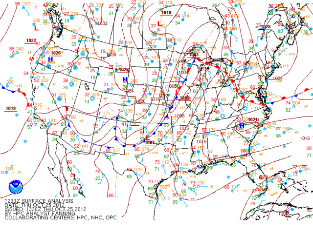
CrazyC83 is right. It's already starting. See how Sandy is beginning to push into the strong 1021 mb high to the north. That high is merging with a very strong 1028 mb high to the northeast . That is making the pressure gradient tighter (isobars are packing tighter together over Florida) and it will get worse because that high is not going to budge much at all.
0 likes
-
AdamFirst

- S2K Supporter

- Posts: 2490
- Age: 36
- Joined: Thu Aug 14, 2008 10:54 am
- Location: Port Saint Lucie, FL
Re: ATL: SANDY - Hurricane - Discussion
Local sports radio personalities are ranting about school closures in South Florida
Shows the amount of worry and urgency here
A laugh and a shrug
Shows the amount of worry and urgency here
A laugh and a shrug
0 likes
Dolphins Marlins Canes Golden Panthers HEAT
Andrew 1992 - Irene 1999 - Frances 2004 - Jeanne 2004 - Wilma 2005 - Fay 2008 - Isaac 2012 - Matthew 2016 - Irma 2017 - Dorian 2019 - Ian 2022 - Nicole 2022 - Milton 2024
Andrew 1992 - Irene 1999 - Frances 2004 - Jeanne 2004 - Wilma 2005 - Fay 2008 - Isaac 2012 - Matthew 2016 - Irma 2017 - Dorian 2019 - Ian 2022 - Nicole 2022 - Milton 2024
-
Hurricane Alexis

- Category 2

- Posts: 683
- Age: 29
- Joined: Thu Jun 14, 2012 7:59 pm
- Location: Miami,Florida
Re: ATL: SANDY - Hurricane - Discussion
Could Sandy be similar to Gordon of 1994 in terms of effects in Florida as it may be more subtropical in it's closest approach?
0 likes
Personal Forecast Disclaimer:
The posts in this forum are NOT official forecast and should not be used as such. They are just the opinion of the poster and may or may not be backed by sound meteorological data. They are NOT endorsed by any professional institution or storm2k.org. For official information, please refer to the NHC and NWS products.
The posts in this forum are NOT official forecast and should not be used as such. They are just the opinion of the poster and may or may not be backed by sound meteorological data. They are NOT endorsed by any professional institution or storm2k.org. For official information, please refer to the NHC and NWS products.
-
x-y-no

- Category 5

- Posts: 8359
- Age: 65
- Joined: Wed Aug 11, 2004 12:14 pm
- Location: Fort Lauderdale, FL
Re:
bahamaswx wrote:She's definitely not vertically stacked anymore.
I don't see any sign of that from surface to 700mb at least - the flight level wind minimum from the HDOBs coincides perfectly with the surface center fix in the latest VDM.
0 likes
Re: ATL: SANDY - Hurricane - Discussion
For us weather Dummies (I had to look it up)
Baroclinic Forcing - to become an extratropical cyclone, or become absorbed by the large frontal system
Baroclinic Forcing - to become an extratropical cyclone, or become absorbed by the large frontal system
0 likes
-
nativefloridian

- Tropical Storm

- Posts: 172
- Joined: Tue Aug 21, 2012 2:48 pm
- Location: Pembroke Pines, FL
Re: ATL: SANDY - Hurricane - Discussion
ozonepete wrote:AdamFirst wrote:When can we start seeing the baroclinic forcing?
CrazyC83 is right. It's already starting. See how Sandy is beginning to push into the strong 1021 mb high to the north. That high is merging with a very strong 1028 mb high to the northeast . That is making the pressure gradient tighter (isobars are packing tighter together over Florida) and it will get worse because that high is not going to budge much at all.
So am I correct in understanding we may here along the SE coast of Florida see the winds pick up, but it will be more associated with baroclinic forcing rather than from Sandy's wind field?
0 likes
Re: ATL: SANDY - Hurricane - Discussion
Overcast here on the edge of Sandy's outflow. Light wind. Cool.
0 likes
-
CrazyC83
- Professional-Met
- Posts: 34315
- Joined: Tue Mar 07, 2006 11:57 pm
- Location: Deep South, for the first time!
Re: ATL: SANDY - Hurricane - Discussion
jhpigott wrote:ozonepete wrote:AdamFirst wrote:When can we start seeing the baroclinic forcing?
CrazyC83 is right. It's already starting. See how Sandy is beginning to push into the strong 1021 mb high to the north. That high is merging with a very strong 1028 mb high to the northeast . That is making the pressure gradient tighter (isobars are packing tighter together over Florida) and it will get worse because that high is not going to budge much at all.
So am I correct in understanding we may here along the SE coast of Florida see the winds pick up, but it will be more associated with baroclinic forcing rather than from Sandy's wind field?
That is correct. There is very little wind at all in the NW side of the storm (way less than TS force), the isobars will be the guiding force.
0 likes
Re: ATL: SANDY - Hurricane - Discussion
Q. As Sandy continues to intensify and feels the H.P Ridge to her north,
would a stronger Storm tend to steer more towards N.W (W.N.W) - than a weaker Storm. (or the opposite?)
would a stronger Storm tend to steer more towards N.W (W.N.W) - than a weaker Storm. (or the opposite?)
0 likes
Tight isobars = tylenol headache for me (lol)...
P.S. Hoping that that is only the case within a few degrees of the system - sometimes that does happen, as I recall but as posted the highs to the northeast are pretty strong...
P.S. Hoping that that is only the case within a few degrees of the system - sometimes that does happen, as I recall but as posted the highs to the northeast are pretty strong...
Last edited by Frank2 on Thu Oct 25, 2012 9:44 am, edited 1 time in total.
0 likes
-
Aric Dunn
- Category 5
- Posts: 21238
- Age: 43
- Joined: Sun Sep 19, 2004 9:58 pm
- Location: Ready for the Chase.
- Contact:
For those who say that TS conditions are not likely ( for some reason) many reports coming of near sustained TS winds and gusting to 50mph and she is quite a good distance away. when the Nnw turn things will likely get worse. far SE florida may be spared but farther up the coast where she will make her closest approach may see higher winds than 50.
0 likes
Note: If I make a post that is brief. Please refer back to previous posts for the analysis or reasoning. I do not re-write/qoute what my initial post said each time.
If there is nothing before... then just ask
Space & Atmospheric Physicist, Embry-Riddle Aeronautical University,
I believe the sky is falling...
If there is nothing before... then just ask
Space & Atmospheric Physicist, Embry-Riddle Aeronautical University,
I believe the sky is falling...
-
CrazyC83
- Professional-Met
- Posts: 34315
- Joined: Tue Mar 07, 2006 11:57 pm
- Location: Deep South, for the first time!
Re:
Aric Dunn wrote:For those who say that TS conditions are not likely ( for some reason) many reports coming of near sustained TS winds and gusting to 50mph and she is quite a good distance away. when the Nnw turn things will likely get worse. far SE florida may be spared but farther up the coast where she will make her closest approach may see higher winds than 50.
Yes, that is from the pressure gradient for the most part and not convection, another sign of beginning the transition.
0 likes
Re: ATL: SANDY - Hurricane - Discussion
The eye was just closing over from land interaction when it emerged. We'll see how quickly it recovers.
Sandy went right over the highest peak in Jamaica, Blue Mountain, and never flinched.
Euro says Jet will negative tilt near the Northeast.
Sandy went right over the highest peak in Jamaica, Blue Mountain, and never flinched.
Euro says Jet will negative tilt near the Northeast.
Last edited by Sanibel on Thu Oct 25, 2012 9:46 am, edited 1 time in total.
0 likes
-
cycloneye

- Admin

- Posts: 149505
- Age: 69
- Joined: Thu Oct 10, 2002 10:54 am
- Location: San Juan, Puerto Rico
Re: ATL: SANDY - Hurricane - Discussion
11 AM advisory forecast track. Look at that left hook at the end.

0 likes
Visit the Caribbean-Central America Weather Thread where you can find at first post web cams,radars
and observations from Caribbean basin members Click Here
and observations from Caribbean basin members Click Here
-
Aric Dunn
- Category 5
- Posts: 21238
- Age: 43
- Joined: Sun Sep 19, 2004 9:58 pm
- Location: Ready for the Chase.
- Contact:
Re: Re:
CrazyC83 wrote:Aric Dunn wrote:For those who say that TS conditions are not likely ( for some reason) many reports coming of near sustained TS winds and gusting to 50mph and she is quite a good distance away. when the Nnw turn things will likely get worse. far SE florida may be spared but farther up the coast where she will make her closest approach may see higher winds than 50.
Yes, that is from the pressure gradient for the most part and not convection, another sign of beginning the transition.
none the less TS warnings were quite needed.
0 likes
Note: If I make a post that is brief. Please refer back to previous posts for the analysis or reasoning. I do not re-write/qoute what my initial post said each time.
If there is nothing before... then just ask
Space & Atmospheric Physicist, Embry-Riddle Aeronautical University,
I believe the sky is falling...
If there is nothing before... then just ask
Space & Atmospheric Physicist, Embry-Riddle Aeronautical University,
I believe the sky is falling...
Re: ATL: SANDY - Hurricane - Discussion
The 11 a.m. package is now available...
P.S. It's already nearing 23N - only 3 degrees from our latitude, and perhaps will already be north of our latitude by sunset - well ahead of the thinking 36 hours ago...
P.P.S. Just my guess, but that NYC landfall will never happen - just too unlikely at this time of year...
Frank
P.S. It's already nearing 23N - only 3 degrees from our latitude, and perhaps will already be north of our latitude by sunset - well ahead of the thinking 36 hours ago...
P.P.S. Just my guess, but that NYC landfall will never happen - just too unlikely at this time of year...
Frank
Last edited by Frank2 on Thu Oct 25, 2012 9:52 am, edited 1 time in total.
0 likes


Re: ATL: SANDY - Hurricane - Discussion
cycloneye wrote:11 AM advisory forecast track. Look at that left hook at the end.
http://oi46.tinypic.com/2rmw8ih.jpg
Aimed right at my house
Two TS Events in two years? Who moved NJ down to the GoM?
0 likes
Andrew '92 Opal '95 Blizzard '96 Izzy '03 Irene '11 Sandy '12
The following post is NOT an official forecast and should not be used as such. It is just the opinion is not be backed by sound meteorological data. It is NOT endorsed by any professional institution including storm2k.org For Official Information please refer to the NHC and NWS products.
The following post is NOT an official forecast and should not be used as such. It is just the opinion is not be backed by sound meteorological data. It is NOT endorsed by any professional institution including storm2k.org For Official Information please refer to the NHC and NWS products.
Who is online
Users browsing this forum: No registered users and 109 guests