WeatherGuesser wrote:Have we set a pressure record yet? I'm still seeing 951.
it'll probably be lower, but that's just a guess based on model runs from earlier.
Moderator: S2k Moderators

WeatherGuesser wrote:Have we set a pressure record yet? I'm still seeing 951.

IN ADDITION...HURRICANE-FORCE WINDS ARE EXPECTED ALONG PORTIONS OF THE COAST BETWEEN CHINCOTEAGUE VIRGINIA AND CHATHAM MASSACHUSETTS.
THIS INCLUDES THE MIDDLE AND UPPER CHESAPEAKE BAY...DELAWARE BAY...AND THE COASTS OF THE NORTHERN DELMARVA PENINSULA...NEW JERSEY...THE NEW YORK CITY AREA...LONG ISLAND...CONNECTICUT...AND RHODE ISLAND.
RL3AO wrote:Very cool site I thought you guys might like.


RL3AO wrote:Yeah I did. Got distracted by the TV.
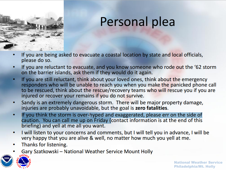
Personally plea from NWS Mount Holly.


curmy wrote:Hi Everyone! I've been a long time lurker and decided I would post before we lose power...
I'm about 25 miles inland "as the crow flyes" from Lewes/Rehobeth, Delaware. Currently, we are getting light rain and light wind. We started our preps on Thursday, which basically consisted of taking "everything" out of the shed and attic. The generator started on the first pull, Thank you God! You name it, we got it. Didn't need to go to the store one thing! We are now done and ready.
We are rural and are on well water, so we will be the last to get power back on. We spent all day yesterday filling 50 gallon jugs with water and 5 gallon containers. Solar showers are filled too. I'm doing all my baking today. The pine-apple upside down cake looks devine
The pantry full of home canned foods are a blessing at a time like this.
I just heard on the local tv that mandatory evacs are underway in Ocean City and the Delaware beaches (kent county). I've also gotten several emails from Verizon advising that connectivity might be an issue during the storm. Duh, Ya' think? So, I went to my inbox and sure enough, I can't send or receive messages....No big deal, but I will miss being online and losing the satellite. The weather radio, battery operated tv, and library will fill the gap.
Thanks to everyone for all you do here. It means alot!
Regards,
Curmy
Users browsing this forum: No registered users and 11 guests