Texas Winter 2012-2013

Winter Weather Discussion

Moderator: S2k Moderators

Forum rules

The posts in this forum are NOT official forecast and should not be used as such. They are just the opinion of the poster and may or may not be backed by sound meteorological data. They are NOT endorsed by any professional institution or STORM2K.

Help Support Storm2K
Message
Author
User avatar
wxman57
Moderator-Pro Met
Moderator-Pro Met
Posts: 22978
Age: 67
Joined: Sat Jun 21, 2003 8:06 pm
Location: Houston, TX (southwest)

Re: Texas Winter 2012-2013

#361 Postby wxman57 » Tue Nov 27, 2012 3:59 pm

HockeyTx82 wrote:I see wxman57 poking around. What are your thoughts on this mid December possible pattern change?


I'm completely against any change to cooler weather...

My coworker and admitted cold-mongerer has been talking of a pattern change around the second week of December. I can see the 12Z GFS indicating a more stormy pattern (and cold) down south. Hope it's wrong.
0 likes   

User avatar
Ntxw
Storm2k Moderator
Storm2k Moderator
Posts: 22785
Joined: Wed Oct 21, 2009 6:34 pm
Location: DFW, Texas

Re: Texas Winter 2012-2013

#362 Postby Ntxw » Tue Nov 27, 2012 8:01 pm

orangeblood wrote:Here is an interesting CFSv2 forecast for snowfall leading up to Christmas...seems to back up what JB has been touting


I just saw his blog on it. One of the runs had like a foot of snow all the way down to the gulf coast :lol: How fun would that be? Of course probably fantasy. But I do like the more snow cover idea next month in the continental US.
0 likes   
The above post and any post by Ntxw is NOT an official forecast and should not be used as such. It is just the opinion of the poster and may or may not be backed by sound meteorological data. It is NOT endorsed by any professional institution including Storm2k. For official information, please refer to NWS products.

  Help support Storm2K!
Help Support Storm2K

orangeblood
S2K Supporter
S2K Supporter
Posts: 3714
Joined: Tue Dec 15, 2009 6:14 pm
Location: Fort Worth, TX

Re: Texas Winter 2012-2013

#363 Postby orangeblood » Tue Nov 27, 2012 8:05 pm

To illustrate what Ntxw is talking about... I'm sure wxman57 will love one of these ensemble runs in the 15-25 day range (Dec 12-22). Santa would be right in his element as he's traveling the rooftops of Houston

Image
0 likes   

richtrav
Tropical Storm
Tropical Storm
Posts: 184
Joined: Mon Sep 19, 2005 9:48 pm
Location: South Texas

Re: Texas Winter 2012-2013

#364 Postby richtrav » Wed Nov 28, 2012 1:16 am

wxman57 wrote:
I'm completely against any change to cooler weather...


Me too, we deserve another 3 or 4 more mild winters after having to put up with the nuisances of 2010 and 2011. Let the snow go to New Mexico where it belongs, I was hoping to get a ski trip in before Christmas
0 likes   

User avatar
Portastorm
Storm2k Moderator
Storm2k Moderator
Posts: 9914
Age: 63
Joined: Fri Jul 11, 2003 9:16 am
Location: Round Rock, TX
Contact:

Re: Texas Winter 2012-2013

#365 Postby Portastorm » Wed Nov 28, 2012 10:24 am

richtrav wrote:
wxman57 wrote:
I'm completely against any change to cooler weather...


Me too, we deserve another 3 or 4 more mild winters after having to put up with the nuisances of 2010 and 2011. Let the snow go to New Mexico where it belongs, I was hoping to get a ski trip in before Christmas


You two deserve each other! :lol:

Heat Misers ... sheesh.
0 likes   
Any forecasts under my name are to be taken with a grain of salt. Get your best forecasts from the National Weather Service and National Hurricane Center.

orangeblood
S2K Supporter
S2K Supporter
Posts: 3714
Joined: Tue Dec 15, 2009 6:14 pm
Location: Fort Worth, TX

Re: Texas Winter 2012-2013

#366 Postby orangeblood » Wed Nov 28, 2012 11:34 am

We need that PNA to pop positive before we start getting too excited about any prospects of winter weather around here....that pesky Gulf of Alaska trough needs to move elsewhere!!
0 likes   

SaskatchewanScreamer

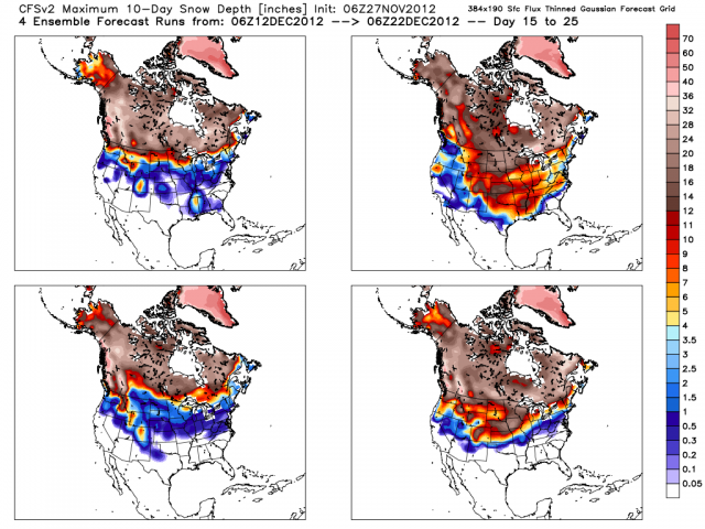
#367 Postby SaskatchewanScreamer » Wed Nov 28, 2012 11:47 am

To whet your appetite......now if you really want our cold you had better pray Mother Nature comes on board.

It's official: Regina, Saskatchewan, saw record snowfall in November
Most of the city's snowfall this month came in two large events. Courtesy: David Dunster


Staff writers

November 27, 2012 — The city of Regina saw about half its total average amount of winter snow fall in just the month of November.


With a little under a month to go before the "official" start of winter, the city of Regina, Saskatchewan, has already broken records for its snowiest November.

At a few days shy of December, the city has received between 55 and 70 cm of snow for the entire month of November, depending on the location.

That's more than the 1941 November record of 53 cm. The historical average for November is around 14 cm.

"It's roughly half of what Regina gets the whole winter," Weather Network meteorologist Mark Robinson says.

"What's unusual is, most of it hit in two big storms, two extreme events."

Robinson says that's in contrast to the more historical trend of a steady build-up, making the snowfall harder to predict.

He said increasing frequency of extreme seasonal events, such as some of the winter-like storms that have hit the Prairie Provinces this year, are characteristic about what some scientists expect of climate change.


Frigid temperatures and snow to blast Alberta
Snow and frigid temperatures making it feel like winter in the Prairies

Staff writers

November 28, 2012 — There's still several weeks left until the official start to winter, but try telling that to residents in Alberta. Another snow storm is set to bring over 10 cm of snow to the province.

Frigid temperatures and heavy snow will make for a wintery couple of days across Alberta.

A deep Arctic ridge that's sinking south will bring below normal temperatures to much of the province on Wednesday.

Residents are urged to dress appropriately as windchills could reach near -40 in the High Level region. That means dressing in layers, covering your hands, ears and other extremities, and wearing proper footwear to prevent falls when walking in snow and ice.

Officials say it takes less than 10 minutes to get frostbite when your skin is exposed at these extreme windchill values.


Heavy snow could also make for a tricky commute in central Alberta through Thursday.

Between 10-20 cm of snow is expected in the hardest hit areas, including the city of Edmonton, where a snowfall warning has been issued.

Motorists are urged to adjust their driving habits as visibility is reduced and road conditions deteriorate.

Wondering what the winter season will be like in your area this year? Check The Weather Network's 2012/2013 Winter Outlook.
0 likes   

SaskatchewanScreamer

#368 Postby SaskatchewanScreamer » Wed Nov 28, 2012 12:10 pm

Now should I start up my fans so that you get all of the above???? :cheesy:
0 likes   

User avatar
~FlipFlopGirl~
Tropical Depression
Tropical Depression
Posts: 52
Age: 46
Joined: Sat Jul 24, 2010 7:43 pm
Location: Waco,TX

#369 Postby ~FlipFlopGirl~ » Wed Nov 28, 2012 1:46 pm

I am sick of the 70 and 80's - its time to turn off the AC unit for good- And have not seen a drop of rain in Waco since who knows how long- I can't get into the Christmas Spirit- when its 79F- I am content with one snow day- and then good for the year-
0 likes   

User avatar
vbhoutex
Storm2k Executive
Storm2k Executive
Posts: 29112
Age: 73
Joined: Wed Oct 09, 2002 11:31 pm
Location: Cypress, TX
Contact:

Re:

#370 Postby vbhoutex » Wed Nov 28, 2012 1:47 pm

SaskatchewanScreamer wrote:Now should I start up my fans so that you get all of the above???? :cheesy:

Get those fans spinning!!! We would like to know what "real" Winter is like.
0 likes   
Skywarn, C.E.R.T.
Please click below to donate to STORM2K to help with the expenses of keeping the site going:
Image

User avatar
Ntxw
Storm2k Moderator
Storm2k Moderator
Posts: 22785
Joined: Wed Oct 21, 2009 6:34 pm
Location: DFW, Texas

#371 Postby Ntxw » Wed Nov 28, 2012 9:50 pm

The AO continues it's trek down. This is modeled well and probably why we've seen the global models go for a continental trough later in their runs, also is consistent with the displacement of the PV at the upper levels.

Image
0 likes   
The above post and any post by Ntxw is NOT an official forecast and should not be used as such. It is just the opinion of the poster and may or may not be backed by sound meteorological data. It is NOT endorsed by any professional institution including Storm2k. For official information, please refer to NWS products.


  Help support Storm2K!

Help Support Storm2K


Patriot12
Tropical Low
Tropical Low
Posts: 27
Joined: Mon Nov 05, 2012 5:03 pm
Location: Coastal Bend

Re:

#372 Postby Patriot12 » Thu Nov 29, 2012 5:56 am

Ntxw wrote:The AO continues it's trek down. This is modeled well and probably why we've seen the global models go for a continental trough later in their runs, also is consistent with the displacement of the PV at the upper levels.

Image


Translation please?
0 likes   

User avatar
SoupBone
Category 5
Category 5
Posts: 3111
Joined: Tue Sep 20, 2005 5:24 pm

Re: Texas Winter 2012-2013

#373 Postby SoupBone » Thu Nov 29, 2012 9:34 am

wxman57 wrote:
HockeyTx82 wrote:I see wxman57 poking around. What are your thoughts on this mid December possible pattern change?


I'm completely against any change to cooler weather...

My coworker and admitted cold-mongerer has been talking of a pattern change around the second week of December. I can see the 12Z GFS indicating a more stormy pattern (and cold) down south. Hope it's wrong.


I don't know why but I'm laughing at each post you make here. I guess it's because during hurricane season, we're so serious, but these winter threads are a whole lot lighter. LET IT SNOW! :lol: :cold: :froze:

Image
0 likes   
Personal Forecast Disclaimer:
The posts in this forum are NOT official forecast and should not be used as such. They are just the opinion of the poster and may or may not be backed by sound meteorological data. They are NOT endorsed by any professional institution or storm2k.org. For official information, please refer to the NHC and NWS products.

User avatar
Portastorm
Storm2k Moderator
Storm2k Moderator
Posts: 9914
Age: 63
Joined: Fri Jul 11, 2003 9:16 am
Location: Round Rock, TX
Contact:

Re: Texas Winter 2012-2013

#374 Postby Portastorm » Thu Nov 29, 2012 10:11 am

YoungTurk, forgive those of us who have been around awhile who get locked into using acronyms and what may appear as Egyptian heiroglyphics. Ntxw is showing a chart of the registered and predicted numerical values for something called the Arctic Oscillation (AO). In very simple terms, when the AO is negative or really negative, the chances of cold air impacting Texas are better than when it is neutral or positive. You also will see us refer to the NAO which is the North Atlantic Oscillation.

For some good reading on the subject, and it won't take you long, check out this link:

http://www.nc-climate.ncsu.edu/climate/patterns/NAO.html
0 likes   
Any forecasts under my name are to be taken with a grain of salt. Get your best forecasts from the National Weather Service and National Hurricane Center.

Patriot12
Tropical Low
Tropical Low
Posts: 27
Joined: Mon Nov 05, 2012 5:03 pm
Location: Coastal Bend

Re: Texas Winter 2012-2013

#375 Postby Patriot12 » Thu Nov 29, 2012 11:52 am

Portastorm wrote:YoungTurk, forgive those of us who have been around awhile who get locked into using acronyms and what may appear as Egyptian heiroglyphics. Ntxw is showing a chart of the registered and predicted numerical values for something called the Arctic Oscillation (AO). In very simple terms, when the AO is negative or really negative, the chances of cold air impacting Texas are better than when it is neutral or positive. You also will see us refer to the NAO which is the North Atlantic Oscillation.

For some good reading on the subject, and it won't take you long, check out this link:

http://www.nc-climate.ncsu.edu/climate/patterns/NAO.html


Thank you for one of the best (if not the best) responses to a question I've ever seen on the internet.
0 likes   

User avatar
Big O
Category 1
Category 1
Posts: 252
Age: 55
Joined: Sun Sep 16, 2007 4:40 pm
Location: McAllen, Texas

Re: Texas Winter 2012-2013

#376 Postby Big O » Thu Nov 29, 2012 3:56 pm

I asked Fred Schmude with Impact Weather the following questions this morning. His answers provide promise for those of us who really like winter weather. See below:

Q: What would the various teleconnection indices have to look like for trough to be centered along central CONUS as opposed to being situated along east coast? Any chance of this happening?

A: If we see the East Pac and Atlantic Blocks set up a little farther to the west, then we could see the main trough axis set up shop right across the Plains. This of course would be good news for the Plains and Midwest because it would increase the likelihood of more rain/snow. Even though this is a possibility (~20%), the main favored position is still the Eastern U.S. and Canada.

Q: Any chance of a McFarland Signature setting up this winter?

A: This is the type of weather pattern where we could see something as extreme as a McFarland Signature bringing bitterly cold air all the way south to the Rio Grande Valley. Last winter the risk of that kind of a pattern was less than 10%...this year I put the risk at 20-30%. The best chance of a McFarland Signature will be during the last 10 days of Dec through Jan.

Keep hope alive!!! :cold: :froze:
0 likes   

User avatar
Portastorm
Storm2k Moderator
Storm2k Moderator
Posts: 9914
Age: 63
Joined: Fri Jul 11, 2003 9:16 am
Location: Round Rock, TX
Contact:

Re: Texas Winter 2012-2013

#377 Postby Portastorm » Thu Nov 29, 2012 4:58 pm

Hey Big O, thanks for sharing that information! Cool stuff. :D
0 likes   
Any forecasts under my name are to be taken with a grain of salt. Get your best forecasts from the National Weather Service and National Hurricane Center.

User avatar
Portastorm
Storm2k Moderator
Storm2k Moderator
Posts: 9914
Age: 63
Joined: Fri Jul 11, 2003 9:16 am
Location: Round Rock, TX
Contact:

Re: Texas Winter 2012-2013

#378 Postby Portastorm » Thu Nov 29, 2012 5:09 pm

A MUCH STRONGER FRONT AND ASSOCIATED UPPER LEVEL PATTERN CHANGE
TOWARD COLDER CONDITIONS APPEARS IN STORE FOR NEXT WEEKEND. WHILE
BEYOND OUR FORECAST RANGE FOR SPECIFICITY...OUTDOOR ACTIVITIES
WILL BE MUCH MORE PLEASANT THIS WEEKEND THAN NEXT...PLAN ACCORDINGLY.


No ... this was not from the Portastorm Weather Center! :wink:

It's the last paragraph from today's afternoon forecast discussion out of EWX (National Weather Service Forecast Office Austin/San Antonio--the "EWX" stands for New Braunfels, which is where the office is located).
0 likes   
Any forecasts under my name are to be taken with a grain of salt. Get your best forecasts from the National Weather Service and National Hurricane Center.

User avatar
somethingfunny
ChatStaff
ChatStaff
Posts: 3926
Age: 37
Joined: Thu May 31, 2007 10:30 pm
Location: McKinney, Texas

#379 Postby somethingfunny » Thu Nov 29, 2012 5:50 pm

This isn't totally un-weather related: Has anybody else come down with this terrible flu/cold/sinus whatever bug?
0 likes   
I am not a meteorologist, and any posts made by me are not official forecasts or to be interpreted as being intelligent. These posts are just my opinions and are probably silly opinions.

User avatar
gboudx
S2K Supporter
S2K Supporter
Posts: 4080
Joined: Thu Sep 04, 2003 1:39 pm
Location: Rockwall, Tx but from Harvey, La

Re:

#380 Postby gboudx » Thu Nov 29, 2012 7:15 pm

somethingfunny wrote:This isn't totally un-weather related: Has anybody else come down with this terrible flu/cold/sinus whatever bug?


I developed a sinus infection from a cold about 2.5 weeks ago. I've been thru 1 round of Amoxiccilin, but it didn't completely eradicate it, so now I'm on levaquin.
0 likes   


Return to “Winter Weather”

Who is online

Users browsing this forum: No registered users and 3 guests