JMA up to 95kts.
WTPQ20 RJTD 011800
RSMC TROPICAL CYCLONE ADVISORY
NAME TY 1224 BOPHA (1224)
ANALYSIS
PSTN 011800UTC 05.8N 138.8E GOOD
MOVE WNW 12KT
PRES 940HPA
MXWD 095KT
GUST 135KT
50KT 80NM
30KT 210NM NORTH 180NM SOUTH
FORECAST
24HF 021800UTC 06.8N 134.1E 70NM 70%
MOVE W 12KT
PRES 930HPA
MXWD 100KT
GUST 140KT
48HF 031800UTC 08.0N 128.9E 110NM 70%
MOVE W 13KT
PRES 930HPA
MXWD 100KT
GUST 140KT
72HF 041800UTC 09.8N 123.7E 160NM 70%
MOVE WNW 14KT
PRES 965HPA
MXWD 070KT
GUST 100KT =
WPAC: BOPHA - Remnants
Moderator: S2k Moderators
-
cycloneye

- Admin

- Posts: 149291
- Age: 69
- Joined: Thu Oct 10, 2002 10:54 am
- Location: San Juan, Puerto Rico
Re: WPAC: BOPHA - Typhoon
0 likes
Visit the Caribbean-Central America Weather Thread where you can find at first post web cams,radars
and observations from Caribbean basin members Click Here
and observations from Caribbean basin members Click Here
-
Meow
Bopha may be even stronger when it affects Palau.

TY 1224 (BOPHA)
Issued at 18:45 UTC, 1 December 2012
<Analyses at 01/18 UTC>
Scale -
Intensity Very Strong
Center position N5°50'(5.8°)
E138°50'(138.8°)
Direction and speed of movement WNW 20km/h(12kt)
Central pressure 940hPa
Maximum wind speed near the center 50m/s(95kt)
Maximum wind gust speed 70m/s(135kt)
Area of 50kt winds or more ALL150km(80NM)
Area of 30kt winds or more N390km(210NM)
S330km(180NM)
<Forecast for 02/06 UTC>
Intensity Very Strong
Center position of probability circle N6°20'(6.3°)
E136°30'(136.5°)
Direction and speed of movement W 20km/h(12kt)
Central pressure 935hPa
Maximum wind speed near the center 50m/s(95kt)
Maximum wind gust speed 70m/s(135kt)
Radius of probability circle 90km(50NM)
Storm warning area ALL240km(130NM)
<Forecast for 02/18 UTC>
Intensity Very Strong
Center position of probability circle N6°50'(6.8°)
E134°05'(134.1°)
Direction and speed of movement W 20km/h(12kt)
Central pressure 930hPa
Maximum wind speed near the center 50m/s(100kt)
Maximum wind gust speed 70m/s(140kt)
Radius of probability circle 130km(70NM)
Storm warning area ALL280km(150NM)
<Forecast for 03/18 UTC>
Intensity Very Strong
Center position of probability circle N8°00'(8.0°)
E128°55'(128.9°)
Direction and speed of movement W 25km/h(13kt)
Central pressure 930hPa
Maximum wind speed near the center 50m/s(100kt)
Maximum wind gust speed 70m/s(140kt)
Radius of probability circle 200km(110NM)
Storm warning area ALL350km(190NM)
<Forecast for 04/18 UTC>
Intensity Strong
Center position of probability circle N9°50'(9.8°)
E123°40'(123.7°)
Direction and speed of movement WNW 25km/h(14kt)
Central pressure 965hPa
Maximum wind speed near the center 35m/s(70kt)
Maximum wind gust speed 50m/s(100kt)
Radius of probability circle 300km(160NM)
Storm warning area ALL410km(220NM)
0 likes

-
ManilaTC

- WesternPacificWeather.com

- Posts: 593
- Age: 47
- Joined: Mon Oct 26, 2009 5:13 am
- Location: Mandaluyong City, Philippines
- Contact:
Re: WPAC: BOPHA - Typhoon
Has anyone checked the model runs for 12z? interesting aint it?
0 likes
The above post is NOT official and should not be used as such. It is my opinion and may or may not be backed by sound meteorological data. It is not endorsed by any professional institution or storm2k.org. Please refer to your official national weather agency.
WEB http://goo.gl/JDiKXB | FB https://goo.gl/N5sIle | @ManilaTC
WEB http://goo.gl/JDiKXB | FB https://goo.gl/N5sIle | @ManilaTC
-
ManilaTC
- WesternPacificWeather.com
- Posts: 593
- Age: 47
- Joined: Mon Oct 26, 2009 5:13 am
- Location: Mandaluyong City, Philippines
- Contact:
Re: WPAC: BOPHA - Typhoon
For everyone's reference, I mapped the model runs at 12z, its a dead split on the recurve scenario
but all of em agree on a NE Mindanao-Dinagat Island-Southern Leyte strike.

but all of em agree on a NE Mindanao-Dinagat Island-Southern Leyte strike.
0 likes
The above post is NOT official and should not be used as such. It is my opinion and may or may not be backed by sound meteorological data. It is not endorsed by any professional institution or storm2k.org. Please refer to your official national weather agency.
WEB http://goo.gl/JDiKXB | FB https://goo.gl/N5sIle | @ManilaTC
WEB http://goo.gl/JDiKXB | FB https://goo.gl/N5sIle | @ManilaTC
-
ManilaTC
- WesternPacificWeather.com
- Posts: 593
- Age: 47
- Joined: Mon Oct 26, 2009 5:13 am
- Location: Mandaluyong City, Philippines
- Contact:
Re: WPAC: BOPHA - Typhoon
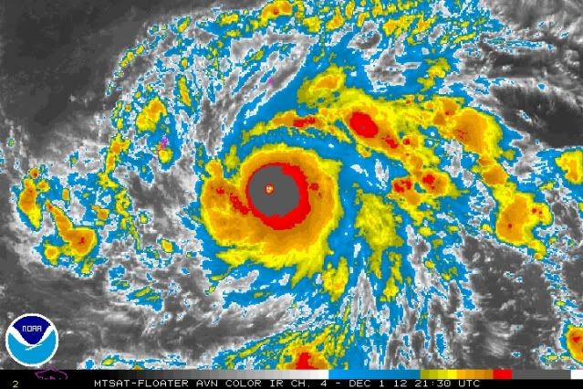
838
TXPQ27 KNES 012121
TCSWNP
A. 26W (BOPHA)
B. 01/2030Z
C. 5.9N
D. 138.2E
E. ONE/MTSAT
F. T7.5/7.5/D1.5/24HRS
G. IR/EIR
H. REMARKS...VERY IMPRESSIVE BOPHA CONTINUES TO INTENSIFY PAST 6 HOURS
AS EYE TEMPERATURE HAS WARMED TO WMG AND EYE IS EMBEDDED WITHIN CMG (USED
CENTER OF EYE TO MEASURE EMBEDDED DISTANCE DUE TO SMALL EYE SIZE LESS THAN
30KM). RING TEMPERATURE IS CDG. THIS MAXES OUT ON TEMPERATURE EXTREMES
FOR CENTRAL FEATURE TO GIVE DT=7.5. MET=7.0 AND PT=7.5. FT IS BASED ON DT.
I. ADDL POSITIONS
7.5 is 155 KNOTS... 285 KPH!!!
0 likes
The above post is NOT official and should not be used as such. It is my opinion and may or may not be backed by sound meteorological data. It is not endorsed by any professional institution or storm2k.org. Please refer to your official national weather agency.
WEB http://goo.gl/JDiKXB | FB https://goo.gl/N5sIle | @ManilaTC
WEB http://goo.gl/JDiKXB | FB https://goo.gl/N5sIle | @ManilaTC
-
supercane4867
- Category 5

- Posts: 4966
- Joined: Wed Nov 14, 2012 10:43 am
Re: WPAC: BOPHA - Typhoon
SUBJ: TYPHOON 26W (BOPHA) WARNING NR 025
WTPN31 PGTW 012100
1. TYPHOON 26W (BOPHA) WARNING NR 025
01 ACTIVE TROPICAL CYCLONE IN NORTHWESTPAC
MAX SUSTAINED WINDS BASED ON ONE-MINUTE AVERAGE
WIND RADII VALID OVER OPEN WATER ONLY
---
WARNING POSITION:
011800Z --- NEAR 5.8N 138.8E
MOVEMENT PAST SIX HOURS - 285 DEGREES AT 14 KTS
POSITION ACCURATE TO WITHIN 010 NM
POSITION BASED ON EYE FIXED BY SATELLITE
PRESENT WIND DISTRIBUTION:
MAX SUSTAINED WINDS - 125 KT, GUSTS 150 KT
WIND RADII VALID OVER OPEN WATER ONLY
RADIUS OF 064 KT WINDS - 030 NM NORTHEAST QUADRANT
030 NM SOUTHEAST QUADRANT
035 NM SOUTHWEST QUADRANT
035 NM NORTHWEST QUADRANT
RADIUS OF 050 KT WINDS - 060 NM NORTHEAST QUADRANT
050 NM SOUTHEAST QUADRANT
050 NM SOUTHWEST QUADRANT
060 NM NORTHWEST QUADRANT
RADIUS OF 034 KT WINDS - 115 NM NORTHEAST QUADRANT
100 NM SOUTHEAST QUADRANT
110 NM SOUTHWEST QUADRANT
135 NM NORTHWEST QUADRANT
REPEAT POSIT: 5.8N 138.8E
---
FORECASTS:
12 HRS, VALID AT:
020600Z --- 6.5N 136.4E
MAX SUSTAINED WINDS - 130 KT, GUSTS 160 KT
WIND RADII VALID OVER OPEN WATER ONLY
RADIUS OF 064 KT WINDS - 035 NM NORTHEAST QUADRANT
035 NM SOUTHEAST QUADRANT
035 NM SOUTHWEST QUADRANT
035 NM NORTHWEST QUADRANT
RADIUS OF 050 KT WINDS - 065 NM NORTHEAST QUADRANT
055 NM SOUTHEAST QUADRANT
055 NM SOUTHWEST QUADRANT
065 NM NORTHWEST QUADRANT
RADIUS OF 034 KT WINDS - 115 NM NORTHEAST QUADRANT
105 NM SOUTHEAST QUADRANT
110 NM SOUTHWEST QUADRANT
130 NM NORTHWEST QUADRANT
VECTOR TO 24 HR POSIT: 285 DEG/ 13 KTS
---
24 HRS, VALID AT:
021800Z --- 7.2N 133.8E
MAX SUSTAINED WINDS - 130 KT, GUSTS 160 KT
WIND RADII VALID OVER OPEN WATER ONLY
RADIUS OF 064 KT WINDS - 035 NM NORTHEAST QUADRANT
035 NM SOUTHEAST QUADRANT
040 NM SOUTHWEST QUADRANT
040 NM NORTHWEST QUADRANT
RADIUS OF 050 KT WINDS - 065 NM NORTHEAST QUADRANT
060 NM SOUTHEAST QUADRANT
060 NM SOUTHWEST QUADRANT
065 NM NORTHWEST QUADRANT
RADIUS OF 034 KT WINDS - 120 NM NORTHEAST QUADRANT
110 NM SOUTHEAST QUADRANT
115 NM SOUTHWEST QUADRANT
130 NM NORTHWEST QUADRANT
VECTOR TO 36 HR POSIT: 285 DEG/ 13 KTS
---
36 HRS, VALID AT:
030600Z --- 7.9N 131.2E
MAX SUSTAINED WINDS - 125 KT, GUSTS 150 KT
WIND RADII VALID OVER OPEN WATER ONLY
RADIUS OF 064 KT WINDS - 040 NM NORTHEAST QUADRANT
035 NM SOUTHEAST QUADRANT
040 NM SOUTHWEST QUADRANT
040 NM NORTHWEST QUADRANT
RADIUS OF 050 KT WINDS - 065 NM NORTHEAST QUADRANT
060 NM SOUTHEAST QUADRANT
060 NM SOUTHWEST QUADRANT
065 NM NORTHWEST QUADRANT
RADIUS OF 034 KT WINDS - 120 NM NORTHEAST QUADRANT
110 NM SOUTHEAST QUADRANT
115 NM SOUTHWEST QUADRANT
130 NM NORTHWEST QUADRANT
VECTOR TO 48 HR POSIT: 285 DEG/ 13 KTS
---
EXTENDED OUTLOOK:
48 HRS, VALID AT:
031800Z --- 8.7N 128.6E
MAX SUSTAINED WINDS - 120 KT, GUSTS 145 KT
WIND RADII VALID OVER OPEN WATER ONLY
RADIUS OF 064 KT WINDS - 040 NM NORTHEAST QUADRANT
040 NM SOUTHEAST QUADRANT
040 NM SOUTHWEST QUADRANT
040 NM NORTHWEST QUADRANT
RADIUS OF 050 KT WINDS - 065 NM NORTHEAST QUADRANT
060 NM SOUTHEAST QUADRANT
060 NM SOUTHWEST QUADRANT
065 NM NORTHWEST QUADRANT
RADIUS OF 034 KT WINDS - 120 NM NORTHEAST QUADRANT
115 NM SOUTHEAST QUADRANT
115 NM SOUTHWEST QUADRANT
130 NM NORTHWEST QUADRANT
VECTOR TO 72 HR POSIT: 290 DEG/ 13 KTS
---
72 HRS, VALID AT:
041800Z --- 10.6N 123.7E
MAX SUSTAINED WINDS - 095 KT, GUSTS 115 KT
WIND RADII VALID OVER OPEN WATER ONLY
VECTOR TO 96 HR POSIT: 300 DEG/ 08 KTS
---
LONG RANGE OUTLOOK:
---
96 HRS, VALID AT:
051800Z --- 12.1N 121.0E
MAX SUSTAINED WINDS - 075 KT, GUSTS 090 KT
WIND RADII VALID OVER OPEN WATER ONLY
VECTOR TO 120 HR POSIT: 300 DEG/ 08 KTS
---
120 HRS, VALID AT:
061800Z --- 13.8N 118.1E
MAX SUSTAINED WINDS - 070 KT, GUSTS 085 KT
WIND RADII VALID OVER OPEN WATER ONLY
---
REMARKS:
012100Z POSITION NEAR 6.0N 138.2E.
MAXIMUM SIGNIFICANT WAVE HEIGHT AT 011800Z IS 48 FEET.
NEXT WARNINGS AT 020300Z, 020900Z, 021500Z AND 022100Z.
//
BT
#0001
NNNN

Affecting Palau as a super typhoon
WTPN31 PGTW 012100
1. TYPHOON 26W (BOPHA) WARNING NR 025
01 ACTIVE TROPICAL CYCLONE IN NORTHWESTPAC
MAX SUSTAINED WINDS BASED ON ONE-MINUTE AVERAGE
WIND RADII VALID OVER OPEN WATER ONLY
---
WARNING POSITION:
011800Z --- NEAR 5.8N 138.8E
MOVEMENT PAST SIX HOURS - 285 DEGREES AT 14 KTS
POSITION ACCURATE TO WITHIN 010 NM
POSITION BASED ON EYE FIXED BY SATELLITE
PRESENT WIND DISTRIBUTION:
MAX SUSTAINED WINDS - 125 KT, GUSTS 150 KT
WIND RADII VALID OVER OPEN WATER ONLY
RADIUS OF 064 KT WINDS - 030 NM NORTHEAST QUADRANT
030 NM SOUTHEAST QUADRANT
035 NM SOUTHWEST QUADRANT
035 NM NORTHWEST QUADRANT
RADIUS OF 050 KT WINDS - 060 NM NORTHEAST QUADRANT
050 NM SOUTHEAST QUADRANT
050 NM SOUTHWEST QUADRANT
060 NM NORTHWEST QUADRANT
RADIUS OF 034 KT WINDS - 115 NM NORTHEAST QUADRANT
100 NM SOUTHEAST QUADRANT
110 NM SOUTHWEST QUADRANT
135 NM NORTHWEST QUADRANT
REPEAT POSIT: 5.8N 138.8E
---
FORECASTS:
12 HRS, VALID AT:
020600Z --- 6.5N 136.4E
MAX SUSTAINED WINDS - 130 KT, GUSTS 160 KT
WIND RADII VALID OVER OPEN WATER ONLY
RADIUS OF 064 KT WINDS - 035 NM NORTHEAST QUADRANT
035 NM SOUTHEAST QUADRANT
035 NM SOUTHWEST QUADRANT
035 NM NORTHWEST QUADRANT
RADIUS OF 050 KT WINDS - 065 NM NORTHEAST QUADRANT
055 NM SOUTHEAST QUADRANT
055 NM SOUTHWEST QUADRANT
065 NM NORTHWEST QUADRANT
RADIUS OF 034 KT WINDS - 115 NM NORTHEAST QUADRANT
105 NM SOUTHEAST QUADRANT
110 NM SOUTHWEST QUADRANT
130 NM NORTHWEST QUADRANT
VECTOR TO 24 HR POSIT: 285 DEG/ 13 KTS
---
24 HRS, VALID AT:
021800Z --- 7.2N 133.8E
MAX SUSTAINED WINDS - 130 KT, GUSTS 160 KT
WIND RADII VALID OVER OPEN WATER ONLY
RADIUS OF 064 KT WINDS - 035 NM NORTHEAST QUADRANT
035 NM SOUTHEAST QUADRANT
040 NM SOUTHWEST QUADRANT
040 NM NORTHWEST QUADRANT
RADIUS OF 050 KT WINDS - 065 NM NORTHEAST QUADRANT
060 NM SOUTHEAST QUADRANT
060 NM SOUTHWEST QUADRANT
065 NM NORTHWEST QUADRANT
RADIUS OF 034 KT WINDS - 120 NM NORTHEAST QUADRANT
110 NM SOUTHEAST QUADRANT
115 NM SOUTHWEST QUADRANT
130 NM NORTHWEST QUADRANT
VECTOR TO 36 HR POSIT: 285 DEG/ 13 KTS
---
36 HRS, VALID AT:
030600Z --- 7.9N 131.2E
MAX SUSTAINED WINDS - 125 KT, GUSTS 150 KT
WIND RADII VALID OVER OPEN WATER ONLY
RADIUS OF 064 KT WINDS - 040 NM NORTHEAST QUADRANT
035 NM SOUTHEAST QUADRANT
040 NM SOUTHWEST QUADRANT
040 NM NORTHWEST QUADRANT
RADIUS OF 050 KT WINDS - 065 NM NORTHEAST QUADRANT
060 NM SOUTHEAST QUADRANT
060 NM SOUTHWEST QUADRANT
065 NM NORTHWEST QUADRANT
RADIUS OF 034 KT WINDS - 120 NM NORTHEAST QUADRANT
110 NM SOUTHEAST QUADRANT
115 NM SOUTHWEST QUADRANT
130 NM NORTHWEST QUADRANT
VECTOR TO 48 HR POSIT: 285 DEG/ 13 KTS
---
EXTENDED OUTLOOK:
48 HRS, VALID AT:
031800Z --- 8.7N 128.6E
MAX SUSTAINED WINDS - 120 KT, GUSTS 145 KT
WIND RADII VALID OVER OPEN WATER ONLY
RADIUS OF 064 KT WINDS - 040 NM NORTHEAST QUADRANT
040 NM SOUTHEAST QUADRANT
040 NM SOUTHWEST QUADRANT
040 NM NORTHWEST QUADRANT
RADIUS OF 050 KT WINDS - 065 NM NORTHEAST QUADRANT
060 NM SOUTHEAST QUADRANT
060 NM SOUTHWEST QUADRANT
065 NM NORTHWEST QUADRANT
RADIUS OF 034 KT WINDS - 120 NM NORTHEAST QUADRANT
115 NM SOUTHEAST QUADRANT
115 NM SOUTHWEST QUADRANT
130 NM NORTHWEST QUADRANT
VECTOR TO 72 HR POSIT: 290 DEG/ 13 KTS
---
72 HRS, VALID AT:
041800Z --- 10.6N 123.7E
MAX SUSTAINED WINDS - 095 KT, GUSTS 115 KT
WIND RADII VALID OVER OPEN WATER ONLY
VECTOR TO 96 HR POSIT: 300 DEG/ 08 KTS
---
LONG RANGE OUTLOOK:
---
96 HRS, VALID AT:
051800Z --- 12.1N 121.0E
MAX SUSTAINED WINDS - 075 KT, GUSTS 090 KT
WIND RADII VALID OVER OPEN WATER ONLY
VECTOR TO 120 HR POSIT: 300 DEG/ 08 KTS
---
120 HRS, VALID AT:
061800Z --- 13.8N 118.1E
MAX SUSTAINED WINDS - 070 KT, GUSTS 085 KT
WIND RADII VALID OVER OPEN WATER ONLY
---
REMARKS:
012100Z POSITION NEAR 6.0N 138.2E.
MAXIMUM SIGNIFICANT WAVE HEIGHT AT 011800Z IS 48 FEET.
NEXT WARNINGS AT 020300Z, 020900Z, 021500Z AND 022100Z.
//
BT
#0001
NNNN
Affecting Palau as a super typhoon
0 likes
-
supercane4867
- Category 5
- Posts: 4966
- Joined: Wed Nov 14, 2012 10:43 am
Re: WPAC: BOPHA - Typhoon
ADT says Bopha is a CAT5
UW - CIMSS
ADVANCED DVORAK TECHNIQUE
ADT-Version 8.1.3
Tropical Cyclone Intensity Algorithm
----- Current Analysis -----
Date : 01 DEC 2012 Time : 210000 UTC
Lat : 5:56:48 N Lon : 138:09:34 E
CI# /Pressure/ Vmax
7.2 / 919.3mb/146.0kt
Final T# Adj T# Raw T#
7.2 7.3 7.3
Estimated radius of max. wind based on IR : 10 km
Center Temp : +13.0C Cloud Region Temp : -78.4C
Scene Type : EYE
Positioning Method : RING/SPIRAL COMBINATION
Ocean Basin : WEST PACIFIC
Dvorak CI > MSLP Conversion Used : PACIFIC
Tno/CI Rules : Constraint Limits : NO LIMIT
Weakening Flag : OFF
0 likes
-
ManilaTC
- WesternPacificWeather.com
- Posts: 593
- Age: 47
- Joined: Mon Oct 26, 2009 5:13 am
- Location: Mandaluyong City, Philippines
- Contact:
Re: WPAC: BOPHA - Typhoon
WTPQ31 PGUM 012141
TCPPQ1
BULLETIN
TYPHOON BOPHA (26W) ADVISORY NUMBER 25
NATIONAL WEATHER SERVICE TIYAN GU WP262012
800 AM CHST SUN DEC 2 2012
...EXTREME TYPHOON BOPHA (26W) STEADILY MOVING TOWARD KOROR...
A TYPHOON WARNING REMAINS IN EFFECT FOR KOROR AND KAYANGEL IN THE
REPUBLIC OF PALAU.
THE TYPHOON WATCH REMAINS IN EFFECT FOR NGULU IN YAP STATE.
THE TROPICAL STORM WATCH REMAINS IN EFFECT FOR SONSOROL IN THE
REPUBLIC OF PALAU.
A TYPHOON WARNING MEANS THAT DAMAGING WINDS OF 39 TO 73 MPH ARE
EXPECTED WITHIN 24 HOURS AND THAT TYPHOON CONDITIONS INCLUDING WINDS
GREATER THAN 73 MPH ARE EXPECTED TO FOLLOW.
A TYPHOON WATCH MEANS THAT TYPHOON CONDITIONS...INCLUDING SUSTAINED
WINDS GREATER THAN 73 MPH...ARE POSSIBLE WITHIN 48 HOURS.
A TROPICAL STORM WATCH MEANS THAT TROPICAL STORM CONDITIONS...
INCLUDING DAMAGING WINDS OF 39 TO 73 MPH...ARE POSSIBLE WITHIN 48
HOURS.
AT 700 AM CHST...2100Z...THE CENTER OF TYPHOON BOPHA WAS LOCATED
NEAR LATITUDE 6.0 DEGREES NORTH AND LONGITUDE 138.2 DEGREES EAST.
THIS IS ABOUT 165 MILES SOUTH-SOUTHEAST OF NGULU
240 MILES SOUTH OF YAP
275 MILES EAST-SOUTHEAST OF KOROR
280 MILES EAST-SOUTHEAST OF KAYANGEL AND
415 MILES EAST OF SONSOROL.
TYPHOON BOPHA IS MOVING TOWARD THE WEST-NORTHWEST AT 15 MPH. THIS
GENERAL MOTION IS EXPECTED TO CONTINUE THROUGH MONDAY.
MAXIMUM SUSTAINED WINDS HAVE INCREASED TO 145 MPH. TYPHOON BOPHA IS
EXPECTED TO INTENSIFY SLIGHTLY OVER THE NEXT 12 HOURS...POSSIBLY
BECOMING A SUPER TYPHOON BY THIS AFTERNOON. TYPHOON FORCE WINDS
EXTEND OUTWARD UP TO 40 MILES FROM THE CENTER AND TROPICAL STORM
FORCE WINDS EXTEND OUTWARD UP TO 155 MILES FROM THE CENTER.
REPEATING THE 700 AM POSITION...6.0 DEGREES NORTH LATITUDE AND 138.2
DEGREES EAST LONGITUDE...MOVING TOWARD THE WEST-NORTHWEST AT 15 MPH
WITH MAXIMUM SUSTAINED WINDS OF 145 MPH.
AN INTERMEDIATE ADVISORY WILL BE ISSUED BY THE NATIONAL WEATHER
SERVICE AT 1100 AM CHST THIS MORNING FOLLOWED BY THE NEXT SCHEDULED
ADVISORY AT 200 PM.
$$
STANKO
0 likes
The above post is NOT official and should not be used as such. It is my opinion and may or may not be backed by sound meteorological data. It is not endorsed by any professional institution or storm2k.org. Please refer to your official national weather agency.
WEB http://goo.gl/JDiKXB | FB https://goo.gl/N5sIle | @ManilaTC
WEB http://goo.gl/JDiKXB | FB https://goo.gl/N5sIle | @ManilaTC
-
supercane4867
- Category 5
- Posts: 4966
- Joined: Wed Nov 14, 2012 10:43 am
Re: WPAC: BOPHA - Typhoon
PGTW:T7.0
KNES:T7.5
CIMSS:CI7.2
All Dovrak estimates indicate Bopha is a CAT5, the JTWC should made it a CAT5 in the next advisory
KNES:T7.5
CIMSS:CI7.2
All Dovrak estimates indicate Bopha is a CAT5, the JTWC should made it a CAT5 in the next advisory
0 likes
-
ozonepete
- Professional-Met

- Posts: 4743
- Joined: Mon Sep 07, 2009 3:23 pm
- Location: From Ozone Park, NYC / Now in Brooklyn, NY
Re: WPAC: BOPHA - Typhoon
0 likes
-
TropicalAnalystwx13

- Category 5
- Posts: 2109
- Age: 28
- Joined: Tue Jul 19, 2011 8:20 pm
- Location: Wilmington, NC
- Contact:
This storm is going to kill over 10,000 people if it keeps going the way it is. Bopha is probably a 175 mph Category 5 super typhoon right now and it's heading straight for an island with a complete crap building code and people that are extremely complacent. Afterwards, it's headed straight towards a portion of the Philippines not accustomed to these types of storms. For example, a tropical storm in 1991 took a similar path. It peaked with winds of 50 mph. That's all. But you know what it's death toll was? Between 5,000 and 8,000. The strongest storm in Palau's history (the island) produced wind gusts below 90 mph. Bopha is expected to produce sustained winds of at least 125 mph.

0 likes
-
wxmann_91

- Category 5
- Posts: 8007
- Age: 34
- Joined: Fri Jul 15, 2005 2:49 pm
- Location: Southern California
- Contact:
Re:
TropicalAnalystwx13 wrote:This storm is going to kill over 10,000 people if it keeps going the way it is. Bopha is probably a 175 mph Category 5 super typhoon right now and it's heading straight for an island with a complete crap building code and people that are extremely complacent. Afterwards, it's headed straight towards a portion of the Philippines not accustomed to these types of storms. For example, a tropical storm in 1991 took a similar path. It peaked with winds of 50 mph. That's all. But you know what it's death toll was? Between 5,000 and 8,000. The strongest storm in Palau's history (the island) produced wind gusts below 90 mph. Bopha is expected to produce sustained winds of at least 125 mph.
Be careful what you say here. 10,000 people is half of Palau's population... it would take something truly cataclysmic for that type of mortality rate. Remember also that Bopha has a relatively tight core. At its current trajectory Bopha's core might just miss the major population centers to the south. Regarding the Philppines, impact there is more a function of rainfall than winds. Tropical Storm Washi last year killed twice as many as the much stronger STY Mike did in 1990. Both impacted similar areas in Mindinao.
0 likes
-
cycloneye
- Admin
- Posts: 149291
- Age: 69
- Joined: Thu Oct 10, 2002 10:54 am
- Location: San Juan, Puerto Rico
Re: WPAC: BOPHA - Typhoon
Oh my Palau. 

0 likes
Visit the Caribbean-Central America Weather Thread where you can find at first post web cams,radars
and observations from Caribbean basin members Click Here
and observations from Caribbean basin members Click Here
-
ozonepete
- Professional-Met
- Posts: 4743
- Joined: Mon Sep 07, 2009 3:23 pm
- Location: From Ozone Park, NYC / Now in Brooklyn, NY
Re: WPAC: BOPHA - Typhoon
0 likes
-
ozonepete
- Professional-Met
- Posts: 4743
- Joined: Mon Sep 07, 2009 3:23 pm
- Location: From Ozone Park, NYC / Now in Brooklyn, NY
Re: Re:
wxmann_91 wrote:TropicalAnalystwx13 wrote:This storm is going to kill over 10,000 people if it keeps going the way it is. Bopha is probably a 175 mph Category 5 super typhoon right now and it's heading straight for an island with a complete crap building code and people that are extremely complacent. Afterwards, it's headed straight towards a portion of the Philippines not accustomed to these types of storms. For example, a tropical storm in 1991 took a similar path. It peaked with winds of 50 mph. That's all. But you know what it's death toll was? Between 5,000 and 8,000. The strongest storm in Palau's history (the island) produced wind gusts below 90 mph. Bopha is expected to produce sustained winds of at least 125 mph.
Be careful what you say here. 10,000 people is half of Palau's population... it would take something truly cataclysmic for that type of mortality rate. Remember also that Bopha has a relatively tight core. At its current trajectory Bopha's core might just miss the major population centers to the south. Regarding the Philppines, impact there is more a function of rainfall than winds. Tropical Storm Washi last year killed twice as many as the much stronger STY Mike did in 1990. Both impacted similar areas in Mindinao.
Your points are well taken and nobody should put a number on expected casualties, but the number of people in the Philippines who are in the path not just for extreme winds but flooding and resultant landslides is in the millions. I think given the lack of secure shelter in those areas this does have the potential to be catastrophic.
0 likes
-
cycloneye
- Admin
- Posts: 149291
- Age: 69
- Joined: Thu Oct 10, 2002 10:54 am
- Location: San Juan, Puerto Rico
Re: WPAC: BOPHA - Typhoon
I would like to see news from Palau in terms of how they have prepared and then the aftermath. Let's see if typhoon chasers went there and news media.
0 likes
Visit the Caribbean-Central America Weather Thread where you can find at first post web cams,radars
and observations from Caribbean basin members Click Here
and observations from Caribbean basin members Click Here
-
wxmann_91
- Category 5
- Posts: 8007
- Age: 34
- Joined: Fri Jul 15, 2005 2:49 pm
- Location: Southern California
- Contact:
Re: Re:
ozonepete wrote:wxmann_91 wrote:TropicalAnalystwx13 wrote:This storm is going to kill over 10,000 people if it keeps going the way it is. Bopha is probably a 175 mph Category 5 super typhoon right now and it's heading straight for an island with a complete crap building code and people that are extremely complacent. Afterwards, it's headed straight towards a portion of the Philippines not accustomed to these types of storms. For example, a tropical storm in 1991 took a similar path. It peaked with winds of 50 mph. That's all. But you know what it's death toll was? Between 5,000 and 8,000. The strongest storm in Palau's history (the island) produced wind gusts below 90 mph. Bopha is expected to produce sustained winds of at least 125 mph.
Be careful what you say here. 10,000 people is half of Palau's population... it would take something truly cataclysmic for that type of mortality rate. Remember also that Bopha has a relatively tight core. At its current trajectory Bopha's core might just miss the major population centers to the south. Regarding the Philppines, impact there is more a function of rainfall than winds. Tropical Storm Washi last year killed twice as many as the much stronger STY Mike did in 1990. Both impacted similar areas in Mindinao.
Your points are well taken and nobody should put a number on expected casualties, but the number of people in the Philippines who are in the path not just for extreme winds but flooding and resultant landslides is in the millions. I think given the lack of secure shelter in those areas this does have the potential to be catastrophic.
Oops, I just realized that I read that as "this storm will kill over 10,000 in Palau" (which would be ridiculous). My bad. But yeah, I agree, there is potential for some serious problems in the Philippines.
0 likes
-
CrazyC83
- Professional-Met
- Posts: 34315
- Joined: Tue Mar 07, 2006 11:57 pm
- Location: Deep South, for the first time!
Re: WPAC: BOPHA - Typhoon
ozonepete wrote::uarrow: I would have to agree that this is a huge disaster in the making. I'm getting that same sinking feeling I got when I realized Sandy would carry a huge surge into the northeast at high tide - the feeling that alot of people in the path were not taking it seriously enough and that they wouldn't prepare because they said "that doesn't happen here.". In this case there are many more people who don't have anywhere to go so we can only hope that officials are setting up secure shelters for them. This is a terrible situation.
As mentioned, this doesn't look like a storm surge setup at all due to the tight core and rapid deepening. Wind is definitely the big threat here. It is all about whether or not that eyewall hits Palau...it could easily miss.
In the Philippines? It all depends on the size and structure there. Too early to tell.
0 likes
Who is online
Users browsing this forum: Google Adsense [Bot] and 11 guests