
WPAC: BOPHA - Remnants
Moderator: S2k Moderators
-
supercane4867
- Category 5

- Posts: 4966
- Joined: Wed Nov 14, 2012 10:43 am
Re: WPAC: BOPHA - Typhoon
Bopha is currently running into the southern edge of subtropical ridge. The question is will it change to a due west movement before hitting Palau, this is the only thing that could save them. Bopha is still going slightly WNW according to the satellite loop
0 likes
-
ozonepete
- Professional-Met

- Posts: 4743
- Joined: Mon Sep 07, 2009 3:23 pm
- Location: From Ozone Park, NYC / Now in Brooklyn, NY
Re: WPAC: BOPHA - Typhoon
CrazyC83 wrote:ozonepete wrote::uarrow: I would have to agree that this is a huge disaster in the making. I'm getting that same sinking feeling I got when I realized Sandy would carry a huge surge into the northeast at high tide - the feeling that alot of people in the path were not taking it seriously enough and that they wouldn't prepare because they said "that doesn't happen here.". In this case there are many more people who don't have anywhere to go so we can only hope that officials are setting up secure shelters for them. This is a terrible situation.
As mentioned, this doesn't look like a storm surge setup at all due to the tight core and rapid deepening. Wind is definitely the big threat here. It is all about whether or not that eyewall hits Palau...it could easily miss.
In the Philippines? It all depends on the size and structure there. Too early to tell.
Hi Crazy! Who mentioned there wouldn't be a surge problem?! There is always a surge and with a storm of this magnitude and it is always considerable. Though this surge won't be like Sandy's due to the very different topography and coastal setup, there will surely be a large dangerous surge. I've never heard of a tight core and rapid deepening causing less of a surge (?). This is now an extreme typhoon and is already pushing high water way out ahead of it. There is always a surge near and out to the right of the eye. If it misses but passes to the south they will be in the extremely dangerous right front quadrant. The danger to the Philippines still dpends on how much strength it maintains before it gets there, as you said.
Last edited by ozonepete on Sat Dec 01, 2012 7:01 pm, edited 1 time in total.
0 likes
-
ozonepete
- Professional-Met
- Posts: 4743
- Joined: Mon Sep 07, 2009 3:23 pm
- Location: From Ozone Park, NYC / Now in Brooklyn, NY
Re: WPAC: BOPHA - Typhoon
supercane4867 wrote:Bopha is currently running into the southern edge of subtropical ridge. The question is will it change to a due west movement before hitting Palau, this is the only thing that could save them. Bopha is still going slightly WNW according to the satellite loop
img http://i45.tinypic.com/2v157he.gif img
If it goes due west it will pass south of Palau and they will be in the most dangerous quadrant. The only good scenario for them is if the core passes to the north and that doesn't look likely now. They are in big trouble now, sadly.
0 likes
-
vbhoutex

- Storm2k Executive

- Posts: 29146
- Age: 74
- Joined: Wed Oct 09, 2002 11:31 pm
- Location: Cypress, TX
- Contact:
Re: WPAC: BOPHA - Typhoon
James Reynolds is there in Palau.
This is from a FB post.James Reynolds
45 minutes ago via mobile
near Tngeronger, Palau
View from the solid concrete motel, 1.5ft above sea level. Our room is in 2nd floor, Bopha due to pass right over us tonight sustained winds of 150mph gusting to 180mph.
0 likes
Skywarn, C.E.R.T.
Please click below to donate to STORM2K to help with the expenses of keeping the site going:

Please click below to donate to STORM2K to help with the expenses of keeping the site going:
-
dexterlabio
- Category 5
- Posts: 3503
- Joined: Sat Oct 24, 2009 11:50 pm
Re: WPAC: BOPHA - Typhoon
is it just me or the JTWC is being conservative in terms of its intensity right now? JMA is now up to 100kts, 10-min ave.
0 likes
Personal Forecast Disclaimer:
The posts in this forum are NOT official forecast and should not be used as such. They are just the opinion of the poster and may or may not be backed by sound meteorological data. They are NOT endorsed by any professional institution or storm2k.org. For official information, please refer to the NHC and NWS products.
The posts in this forum are NOT official forecast and should not be used as such. They are just the opinion of the poster and may or may not be backed by sound meteorological data. They are NOT endorsed by any professional institution or storm2k.org. For official information, please refer to the NHC and NWS products.
-
cycloneye

- Admin
- Posts: 149291
- Age: 69
- Joined: Thu Oct 10, 2002 10:54 am
- Location: San Juan, Puerto Rico
Re: WPAC: BOPHA - Typhoon
vbhoutex wrote:James Reynolds is there in Palau.This is from a FB post.James Reynolds
45 minutes ago via mobile
near Tngeronger, Palau
View from the solid concrete motel, 1.5ft above sea level. Our room is in 2nd floor, Bopha due to pass right over us tonight sustained winds of 150mph gusting to 180mph.
That is good to know as so far no information is comming out from there. James,do the chasing but be safe.
0 likes
Visit the Caribbean-Central America Weather Thread where you can find at first post web cams,radars
and observations from Caribbean basin members Click Here
and observations from Caribbean basin members Click Here
-
supercane4867
- Category 5
- Posts: 4966
- Joined: Wed Nov 14, 2012 10:43 am
Re: WPAC: BOPHA - Typhoon
Up to 60m/s by the CMA
WTPQ20 BABJ 020000
SUBJECTIVE FORECAST
SuperTY BOPHA 1224 (1224) INITIAL TIME 020000 UTC
00HR 6.2N 137.6E 920HPA 60M/S
30KTS 300KM
50KTS 120KM
P12HR WNW 23KM/H
P+24HR 7.2N 133.2E 930HPA 55M/S
P+48HR 8.8N 127.9E 940HPA 52M/S
P+72HR 10.8N 122.6E 965HPA 38M/S
P+96HR 12.3N 120.2E 970HPA 35M/S
P+120HR 14.1N 118.7E 975HPA 33M/S
0 likes
-
supercane4867
- Category 5
- Posts: 4966
- Joined: Wed Nov 14, 2012 10:43 am
Re: WPAC: BOPHA - Typhoon
dexterlabio wrote:is it just me or the JTWC is being conservative in terms of its intensity right now? JMA is now up to 100kts, 10-min ave.
They both are underestimating the intensity IMO, 100kts 10-min sustained is no higher than 125kts 1-min
0 likes
-
euro6208
Re: WPAC: BOPHA - Typhoon
oh my god...satellite estimates are irrelevant at this point...this is probrably already a Super Typhoon with 160 to 165 knots winds...with an extremely small pinhole eye which continues to warm embedded in a very small CDO...if only we had recon for this storm...
0 likes
-
Grifforzer
- Category 1

- Posts: 418
- Joined: Thu Feb 26, 2009 11:27 pm
Re: WPAC: BOPHA - Typhoon
supercane4867 wrote:dexterlabio wrote:is it just me or the JTWC is being conservative in terms of its intensity right now? JMA is now up to 100kts, 10-min ave.
They both are underestimating the intensity IMO, 100kts 10-min sustained is no higher than 125kts 1-min
well ya since JMA does not use a normal 10 min sustained winds average like other RSMC.
100 knots (JMA) would be equivalent to 115 knots (10 min) from other RSMC.
----
I use this to compare wind speed from JMA, IMD, and other RSMC (JMA estimates are not officially released by Japan)
Dvorak #, 10min wind speed avg, JMA wind speed estimate, IMD wind speed avg, U.S. wind speed avg
6.0 100 kt 95 kt 115 kt 115 kt
6.5 115 kt 100 kt 127kt 130 kt
0 likes
-
ozonepete
- Professional-Met
- Posts: 4743
- Joined: Mon Sep 07, 2009 3:23 pm
- Location: From Ozone Park, NYC / Now in Brooklyn, NY
Re: WPAC: BOPHA - Typhoon
Palau may get relatively lucky. Looks like another serious weakening is underway. Look at the latest IR satellite. The western side is getting seriously eroded. Could be some dry air intrusion or beginning of another ERC or a combination of the two but I'm not sure yet. It also will now undergo DMIN as the sun is coming up. Regardless they are going to get slammed, but they may get a much weaker typhoon than it has been most of today. Let's hope so.
0 likes
-
supercane4867
- Category 5
- Posts: 4966
- Joined: Wed Nov 14, 2012 10:43 am
Re: WPAC: BOPHA - Typhoon
Grifforzer wrote:Dvorak #, 10min wind speed avg, JMA wind speed estimate, IMD wind speed avg, U.S. wind speed avg
6.0 100 kt 95 kt 115 kt 115 kt
6.5 115 kt 100 kt 127kt 130 kt
Can you provide the complete chart for this, thanks
0 likes
-
CrazyC83
- Professional-Met
- Posts: 34315
- Joined: Tue Mar 07, 2006 11:57 pm
- Location: Deep South, for the first time!
Re: WPAC: BOPHA - Typhoon
ozonepete wrote:CrazyC83 wrote:ozonepete wrote::uarrow: I would have to agree that this is a huge disaster in the making. I'm getting that same sinking feeling I got when I realized Sandy would carry a huge surge into the northeast at high tide - the feeling that alot of people in the path were not taking it seriously enough and that they wouldn't prepare because they said "that doesn't happen here.". In this case there are many more people who don't have anywhere to go so we can only hope that officials are setting up secure shelters for them. This is a terrible situation.
As mentioned, this doesn't look like a storm surge setup at all due to the tight core and rapid deepening. Wind is definitely the big threat here. It is all about whether or not that eyewall hits Palau...it could easily miss.
In the Philippines? It all depends on the size and structure there. Too early to tell.
Hi Crazy! Who mentioned there wouldn't be a surge problem?! There is always a surge and with a storm of this magnitude and it is always considerable. Though this surge won't be like Sandy's due to the very different topography and coastal setup, there will surely be a large dangerous surge. I've never heard of a tight core and rapid deepening causing less of a surge (?). This is now an extreme typhoon and is already pushing high water way out ahead of it. There is always a surge near and out to the right of the eye. If it misses but passes to the south they will be in the extremely dangerous right front quadrant. The danger to the Philippines still dpends on how much strength it maintains before it gets there, as you said.
Well, what I mean is the surge won't be the primary problem. The small size limits the amount of water that can move out ahead of it. But if the eyewall crosses Palau, it will be like an EF3 or EF4 tornado sandblasted the island...which can be catastrophic itself!!!
0 likes
-
Grifforzer
- Category 1
- Posts: 418
- Joined: Thu Feb 26, 2009 11:27 pm
1.0 25 kt 25 kt 20 kt 25 kt
1.5 25 kt 25 kt 25 kt 25 kt
2.0 30 kt 30 kt 30 kt 35 kt
2.5 35 kt 35 kt 35-40kt 40 kt
3.0 45 kt 45 kt 45-50kt 50_kt
3.5 55 kt 55 kt 50-60kt 55 kt
4.0 65 kt 65 kt 65-70kt 65 kt
4.5 70 kt 70 kt 77-85kt 75 kt
5.0 80 kt 80 kt 90 kt 90 kt
5.5 90 kt 90 kt 102kt 100 kt
6.0 100 kt 95 kt 115kt 115 kt
6.5 115 kt 100 kt 127kt 130 kt
7.0 120 kt 110 kt 140kt 140 kt
7.5 135 kt 115 kt 155kt 155 kt
8.0 150 kt 120 kt 170kt 170 kt
remember the second wind knots column is JMA estimate winds for that Dvorak
Last edited by Grifforzer on Sat Dec 01, 2012 9:01 pm, edited 1 time in total.
0 likes
-
supercane4867
- Category 5
- Posts: 4966
- Joined: Wed Nov 14, 2012 10:43 am
Re: WPAC: BOPHA - Typhoon
JTWC has Bopha peaked at 130kts and going downhill from this point

0 likes
-
euro6208
Re: WPAC: BOPHA - Typhoon
Upgraded to Super Typhoon Bopha!
130 knots still is very conservative...
WTPN31 PGTW 020300
MSGID/GENADMIN/JOINT TYPHOON WRNCEN PEARL HARBOR HI//
SUBJ/TROPICAL CYCLONE WARNING//
RMKS/
1. SUPER TYPHOON 26W (BOPHA) WARNING NR 026
01 ACTIVE TROPICAL CYCLONE IN NORTHWESTPAC
MAX SUSTAINED WINDS BASED ON ONE-MINUTE AVERAGE
WIND RADII VALID OVER OPEN WATER ONLY
---
WARNING POSITION:
020000Z --- NEAR 6.1N 137.6E
MOVEMENT PAST SIX HOURS - 285 DEGREES AT 12 KTS
POSITION ACCURATE TO WITHIN 010 NM
POSITION BASED ON EYE FIXED BY SATELLITE
PRESENT WIND DISTRIBUTION:
MAX SUSTAINED WINDS - 130 KT, GUSTS 160 KT
WIND RADII VALID OVER OPEN WATER ONLY
RADIUS OF 064 KT WINDS - 030 NM NORTHEAST QUADRANT
030 NM SOUTHEAST QUADRANT
035 NM SOUTHWEST QUADRANT
035 NM NORTHWEST QUADRANT
RADIUS OF 050 KT WINDS - 060 NM NORTHEAST QUADRANT
050 NM SOUTHEAST QUADRANT
050 NM SOUTHWEST QUADRANT
060 NM NORTHWEST QUADRANT
RADIUS OF 034 KT WINDS - 115 NM NORTHEAST QUADRANT
100 NM SOUTHEAST QUADRANT
110 NM SOUTHWEST QUADRANT
135 NM NORTHWEST QUADRANT
REPEAT POSIT: 6.1N 137.6E
---
FORECASTS:
12 HRS, VALID AT:
021200Z --- 6.8N 135.1E
MAX SUSTAINED WINDS - 125 KT, GUSTS 150 KT
WIND RADII VALID OVER OPEN WATER ONLY
RADIUS OF 064 KT WINDS - 035 NM NORTHEAST QUADRANT
035 NM SOUTHEAST QUADRANT
035 NM SOUTHWEST QUADRANT
035 NM NORTHWEST QUADRANT
RADIUS OF 050 KT WINDS - 065 NM NORTHEAST QUADRANT
055 NM SOUTHEAST QUADRANT
055 NM SOUTHWEST QUADRANT
065 NM NORTHWEST QUADRANT
RADIUS OF 034 KT WINDS - 115 NM NORTHEAST QUADRANT
105 NM SOUTHEAST QUADRANT
110 NM SOUTHWEST QUADRANT
130 NM NORTHWEST QUADRANT
VECTOR TO 24 HR POSIT: 285 DEG/ 13 KTS
---
24 HRS, VALID AT:
030000Z --- 7.5N 132.5E
MAX SUSTAINED WINDS - 125 KT, GUSTS 150 KT
WIND RADII VALID OVER OPEN WATER ONLY
RADIUS OF 064 KT WINDS - 035 NM NORTHEAST QUADRANT
035 NM SOUTHEAST QUADRANT
040 NM SOUTHWEST QUADRANT
040 NM NORTHWEST QUADRANT
RADIUS OF 050 KT WINDS - 065 NM NORTHEAST QUADRANT
060 NM SOUTHEAST QUADRANT
060 NM SOUTHWEST QUADRANT
065 NM NORTHWEST QUADRANT
RADIUS OF 034 KT WINDS - 120 NM NORTHEAST QUADRANT
110 NM SOUTHEAST QUADRANT
115 NM SOUTHWEST QUADRANT
130 NM NORTHWEST QUADRANT
VECTOR TO 36 HR POSIT: 285 DEG/ 13 KTS
---
36 HRS, VALID AT:
031200Z --- 8.3N 129.9E
MAX SUSTAINED WINDS - 120 KT, GUSTS 145 KT
WIND RADII VALID OVER OPEN WATER ONLY
RADIUS OF 064 KT WINDS - 040 NM NORTHEAST QUADRANT
035 NM SOUTHEAST QUADRANT
040 NM SOUTHWEST QUADRANT
040 NM NORTHWEST QUADRANT
RADIUS OF 050 KT WINDS - 065 NM NORTHEAST QUADRANT
060 NM SOUTHEAST QUADRANT
060 NM SOUTHWEST QUADRANT
065 NM NORTHWEST QUADRANT
RADIUS OF 034 KT WINDS - 120 NM NORTHEAST QUADRANT
110 NM SOUTHEAST QUADRANT
115 NM SOUTHWEST QUADRANT
130 NM NORTHWEST QUADRANT
VECTOR TO 48 HR POSIT: 290 DEG/ 13 KTS
---
EXTENDED OUTLOOK:
48 HRS, VALID AT:
040000Z --- 9.1N 127.4E
MAX SUSTAINED WINDS - 110 KT, GUSTS 135 KT
WIND RADII VALID OVER OPEN WATER ONLY
RADIUS OF 064 KT WINDS - 040 NM NORTHEAST QUADRANT
040 NM SOUTHEAST QUADRANT
040 NM SOUTHWEST QUADRANT
040 NM NORTHWEST QUADRANT
RADIUS OF 050 KT WINDS - 065 NM NORTHEAST QUADRANT
060 NM SOUTHEAST QUADRANT
060 NM SOUTHWEST QUADRANT
065 NM NORTHWEST QUADRANT
RADIUS OF 034 KT WINDS - 120 NM NORTHEAST QUADRANT
115 NM SOUTHEAST QUADRANT
115 NM SOUTHWEST QUADRANT
130 NM NORTHWEST QUADRANT
VECTOR TO 72 HR POSIT: 295 DEG/ 12 KTS
---
72 HRS, VALID AT:
050000Z --- 10.9N 123.1E
MAX SUSTAINED WINDS - 085 KT, GUSTS 105 KT
WIND RADII VALID OVER OPEN WATER ONLY
VECTOR TO 96 HR POSIT: 300 DEG/ 08 KTS
---
LONG RANGE OUTLOOK:
---
96 HRS, VALID AT:
060000Z --- 12.5N 120.3E
MAX SUSTAINED WINDS - 070 KT, GUSTS 085 KT
WIND RADII VALID OVER OPEN WATER ONLY
VECTOR TO 120 HR POSIT: 300 DEG/ 08 KTS
---
120 HRS, VALID AT:
070000Z --- 14.2N 117.4E
MAX SUSTAINED WINDS - 065 KT, GUSTS 080 KT
WIND RADII VALID OVER OPEN WATER ONLY
---
REMARKS:
020300Z POSITION NEAR 6.3N 137.0E.
SUPER TYPHOON (STY) 26W (BOPHA) LOCATED APPROXIMATELY 195 NM EAST-
SOUTHEAST OF PALAU, HAS TRACKED WEST-NORTHWESTWARD AT 12 KNOTS OVER
THE PAST SIX HOURS. MAXIMUM SIGNIFICANT WAVE HEIGHT AT 020000Z IS 52
FEET. NEXT WARNINGS AT 020900Z, 021500Z, 022100Z AND 030300Z.//
NNNN
0 likes
-
cycloneye
- Admin
- Posts: 149291
- Age: 69
- Joined: Thu Oct 10, 2002 10:54 am
- Location: San Juan, Puerto Rico
Re: WPAC: BOPHA - Typhoon
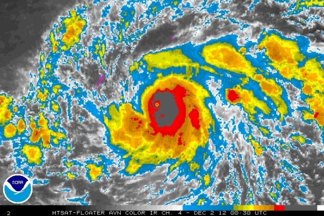
ozonepete wrote:Palau may get relatively lucky. Looks like another serious weakening is underway. Look at the latest IR satellite. The western side is getting seriously eroded. Could be some dry air intrusion or beginning of another ERC or a combination of the two but I'm not sure yet. It also will now undergo DMIN as the sun is coming up. Regardless they are going to get slammed, but they may get a much weaker typhoon than it has been most of today. Let's hope so.
http://i189.photobucket.com/albums/z174 ... 020030.jpg
On water vapor it looks better what is going on. Hopefully is both of what you said and Palau doesn't get a SuperTyphoon hit.

0 likes
Visit the Caribbean-Central America Weather Thread where you can find at first post web cams,radars
and observations from Caribbean basin members Click Here
and observations from Caribbean basin members Click Here
-
supercane4867
- Category 5
- Posts: 4966
- Joined: Wed Nov 14, 2012 10:43 am
Re: WPAC: BOPHA - Typhoon
Seems like another ERC has begun, It's Still very impressive for that Bopha kept its tiny eye for such a long time

0 likes
-
ozonepete
- Professional-Met
- Posts: 4743
- Joined: Mon Sep 07, 2009 3:23 pm
- Location: From Ozone Park, NYC / Now in Brooklyn, NY
Re: WPAC: BOPHA - Typhoon
Fascinating circumstances. JTWC called it a super typhoon (I think rightly so) just before it started a serious weakening. It is clearly already not a super typhoon and doesn't look like it will be before hitting Palau. That's great news. But the bad news is that it looks like the eye will make a direct hit on Palau and it will still be a very formidable typhoon as it does. I would imagine the odds of a direct hit on that tiny island have to be very, very low, but it's going to happen.
0 likes
-
supercane4867
- Category 5
- Posts: 4966
- Joined: Wed Nov 14, 2012 10:43 am
Re: WPAC: BOPHA - Typhoon
euro6208 wrote:SUPER TYPHOON (STY) 26W (BOPHA) LOCATED APPROXIMATELY 195 NM EAST-
SOUTHEAST OF PALAU, HAS TRACKED WEST-NORTHWESTWARD AT 12 KNOTS OVER
THE PAST SIX HOURS. MAXIMUM SIGNIFICANT WAVE HEIGHT AT 020000Z IS 52
FEET. NEXT WARNINGS AT 020900Z, 021500Z, 022100Z AND 030300Z.//
NNNN
52 feet high waves are not good for Palau
0 likes
Who is online
Users browsing this forum: No registered users and 15 guests