WPAC: BOPHA - Remnants

Moderator: S2k Moderators

Message
Author
supercane4867
Category 5
Category 5
Posts: 4966
Joined: Wed Nov 14, 2012 10:43 am

Re: WPAC: BOPHA - Typhoon

#441 Postby supercane4867 » Sun Dec 02, 2012 2:58 am

SUBJ: TYPHOON 26W (BOPHA) WARNING NR 027
WTPN31 PGTW 020900
1. TYPHOON 26W (BOPHA) WARNING NR 027
01 ACTIVE TROPICAL CYCLONE IN NORTHWESTPAC
MAX SUSTAINED WINDS BASED ON ONE-MINUTE AVERAGE
WIND RADII VALID OVER OPEN WATER ONLY
---
WARNING POSITION:
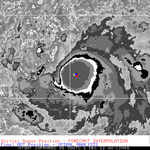
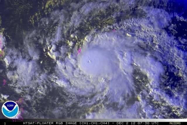
020600Z --- NEAR 6.3N 136.0E
MOVEMENT PAST SIX HOURS - 275 DEGREES AT 16 KTS
POSITION ACCURATE TO WITHIN 020 NM
POSITION BASED ON EYE FIXED BY SATELLITE
PRESENT WIND DISTRIBUTION:
MAX SUSTAINED WINDS - 135 KT, GUSTS 165 KT
WIND RADII VALID OVER OPEN WATER ONLY
RADIUS OF 064 KT WINDS - 030 NM NORTHEAST QUADRANT
025 NM SOUTHEAST QUADRANT
025 NM SOUTHWEST QUADRANT
030 NM NORTHWEST QUADRANT
RADIUS OF 050 KT WINDS - 055 NM NORTHEAST QUADRANT
050 NM SOUTHEAST QUADRANT
050 NM SOUTHWEST QUADRANT
055 NM NORTHWEST QUADRANT
RADIUS OF 034 KT WINDS - 120 NM NORTHEAST QUADRANT
105 NM SOUTHEAST QUADRANT
110 NM SOUTHWEST QUADRANT
125 NM NORTHWEST QUADRANT
REPEAT POSIT: 6.3N 136.0E
---
FORECASTS:
12 HRS, VALID AT:
021800Z --- 6.9N 133.3E
MAX SUSTAINED WINDS - 130 KT, GUSTS 160 KT
WIND RADII VALID OVER OPEN WATER ONLY
RADIUS OF 064 KT WINDS - 030 NM NORTHEAST QUADRANT
030 NM SOUTHEAST QUADRANT
030 NM SOUTHWEST QUADRANT
030 NM NORTHWEST QUADRANT
RADIUS OF 050 KT WINDS - 060 NM NORTHEAST QUADRANT
055 NM SOUTHEAST QUADRANT
055 NM SOUTHWEST QUADRANT
060 NM NORTHWEST QUADRANT
RADIUS OF 034 KT WINDS - 120 NM NORTHEAST QUADRANT
110 NM SOUTHEAST QUADRANT
115 NM SOUTHWEST QUADRANT
125 NM NORTHWEST QUADRANT
VECTOR TO 24 HR POSIT: 285 DEG/ 14 KTS
---
24 HRS, VALID AT:
030600Z --- 7.6N 130.6E
MAX SUSTAINED WINDS - 125 KT, GUSTS 150 KT
WIND RADII VALID OVER OPEN WATER ONLY
RADIUS OF 064 KT WINDS - 035 NM NORTHEAST QUADRANT
030 NM SOUTHEAST QUADRANT
030 NM SOUTHWEST QUADRANT
035 NM NORTHWEST QUADRANT
RADIUS OF 050 KT WINDS - 060 NM NORTHEAST QUADRANT
060 NM SOUTHEAST QUADRANT
060 NM SOUTHWEST QUADRANT
060 NM NORTHWEST QUADRANT
RADIUS OF 034 KT WINDS - 125 NM NORTHEAST QUADRANT
110 NM SOUTHEAST QUADRANT
115 NM SOUTHWEST QUADRANT
125 NM NORTHWEST QUADRANT
VECTOR TO 36 HR POSIT: 290 DEG/ 15 KTS
---
36 HRS, VALID AT:
031800Z --- 8.6N 127.8E
MAX SUSTAINED WINDS - 120 KT, GUSTS 145 KT
WIND RADII VALID OVER OPEN WATER ONLY
RADIUS OF 064 KT WINDS - 035 NM NORTHEAST QUADRANT
035 NM SOUTHEAST QUADRANT
035 NM SOUTHWEST QUADRANT
035 NM NORTHWEST QUADRANT
RADIUS OF 050 KT WINDS - 065 NM NORTHEAST QUADRANT
060 NM SOUTHEAST QUADRANT
060 NM SOUTHWEST QUADRANT
065 NM NORTHWEST QUADRANT
RADIUS OF 034 KT WINDS - 125 NM NORTHEAST QUADRANT
115 NM SOUTHEAST QUADRANT
115 NM SOUTHWEST QUADRANT
130 NM NORTHWEST QUADRANT
VECTOR TO 48 HR POSIT: 290 DEG/ 14 KTS
---
EXTENDED OUTLOOK:
48 HRS, VALID AT:
040600Z --- 9.5N 125.1E
MAX SUSTAINED WINDS - 110 KT, GUSTS 135 KT
WIND RADII VALID OVER OPEN WATER ONLY
RADIUS OF 064 KT WINDS - 035 NM NORTHEAST QUADRANT
035 NM SOUTHEAST QUADRANT
035 NM SOUTHWEST QUADRANT
035 NM NORTHWEST QUADRANT
RADIUS OF 050 KT WINDS - 065 NM NORTHEAST QUADRANT
060 NM SOUTHEAST QUADRANT
060 NM SOUTHWEST QUADRANT
065 NM NORTHWEST QUADRANT
RADIUS OF 034 KT WINDS - 125 NM NORTHEAST QUADRANT
115 NM SOUTHEAST QUADRANT
115 NM SOUTHWEST QUADRANT
125 NM NORTHWEST QUADRANT
VECTOR TO 72 HR POSIT: 300 DEG/ 11 KTS
---
72 HRS, VALID AT:
050600Z --- 11.7N 121.1E
MAX SUSTAINED WINDS - 085 KT, GUSTS 105 KT
WIND RADII VALID OVER OPEN WATER ONLY
RADIUS OF 064 KT WINDS - 030 NM NORTHEAST QUADRANT
030 NM SOUTHEAST QUADRANT
030 NM SOUTHWEST QUADRANT
030 NM NORTHWEST QUADRANT
RADIUS OF 050 KT WINDS - 055 NM NORTHEAST QUADRANT
050 NM SOUTHEAST QUADRANT
050 NM SOUTHWEST QUADRANT
055 NM NORTHWEST QUADRANT
RADIUS OF 034 KT WINDS - 120 NM NORTHEAST QUADRANT
110 NM SOUTHEAST QUADRANT
110 NM SOUTHWEST QUADRANT
120 NM NORTHWEST QUADRANT
VECTOR TO 96 HR POSIT: 300 DEG/ 06 KTS
---
LONG RANGE OUTLOOK:
---
96 HRS, VALID AT:
060600Z --- 13.0N 118.9E
MAX SUSTAINED WINDS - 070 KT, GUSTS 085 KT
WIND RADII VALID OVER OPEN WATER ONLY
VECTOR TO 120 HR POSIT: 320 DEG/ 06 KTS
---
120 HRS, VALID AT:
070600Z --- 14.8N 117.2E
MAX SUSTAINED WINDS - 065 KT, GUSTS 080 KT
WIND RADII VALID OVER OPEN WATER ONLY
---
REMARKS:
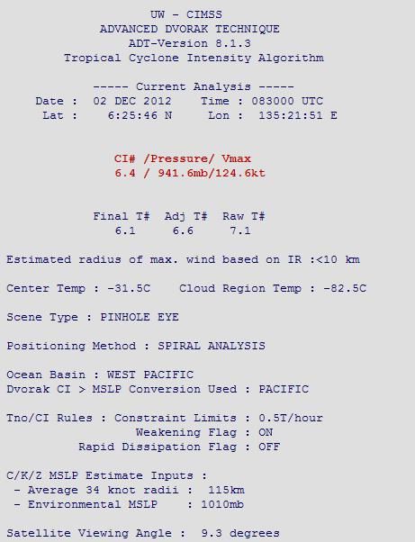
020900Z POSITION NEAR 6.4N 135.3E.
MAXIMUM SIGNIFICANT WAVE HEIGHT AT 020600Z IS 52 FEET.
NEXT WARNINGS AT 021500Z, 022100Z, 030300Z AND 030900Z.
//
BT
#0001
NNNN

Image

I don't think Bopha will maintain typhoon intensity after entering S.China sea, the dry air there will drain it to death
Last edited by supercane4867 on Sun Dec 02, 2012 3:06 am, edited 5 times in total.
0 likes   

User avatar
mrbagyo
Category 5
Category 5
Posts: 3711
Age: 32
Joined: Thu Apr 12, 2012 9:18 am
Location: 14.13N 120.98E
Contact:

Re: WPAC: BOPHA - Typhoon

#442 Postby mrbagyo » Sun Dec 02, 2012 2:59 am

if bopha continues to track west and remains at the same size, then palau might dodge the full impact of this bunch of swirling clouds. but if this turn more NW, then that's another story
maybe the weakening trend is finish, and i'm still expecting a cat 5 out of this ...
Last edited by mrbagyo on Sun Dec 02, 2012 3:00 am, edited 1 time in total.
0 likes   
The posts in this forum are NOT official forecast and should not be used as such. They are just the opinion of the poster and may or may not be backed by sound meteorological data. They are NOT endorsed by any professional institution or storm2k.org. For official information, please refer to RSMC, NHC and NWS products.

ozonepete
Professional-Met
Professional-Met
Posts: 4743
Joined: Mon Sep 07, 2009 3:23 pm
Location: From Ozone Park, NYC / Now in Brooklyn, NY

Re: WPAC: BOPHA - Typhoon

#443 Postby ozonepete » Sun Dec 02, 2012 2:59 am

supercane4867 wrote: img]http://i47.tinypic.com/5f29z6.gif[/img


Yeah, pretty impressive. The core has not only held up even though diurnal minimum should be occurring, but seems to have expanded and consolidated. It wouldn't surprise me if it even ramps up some more. Let's hope it stays on a more westward track for a few more hours - that would be much better for Palau.
0 likes   

dexterlabio
Category 5
Category 5
Posts: 3466
Joined: Sat Oct 24, 2009 11:50 pm

Re: WPAC: BOPHA - Typhoon

#444 Postby dexterlabio » Sun Dec 02, 2012 3:00 am

ozonepete wrote:Btw, especially for you supercane4867, there has been a noticeable westward jog from Bopha over the last couple of hours so it is becoming more possible that Palau could get less of the core than forecast. I suspect it may wobble back north and erase the southward drop it did but if it doesn't do that soon they could really escape with just a brush from the northern side of the damaging core. That would be great news.


I was also expecting a more northern jog because I assume it is doing some sort of stairstepping. But it seems the islands south of Koror will experience the worst from B :lol: opha. At least some good news for Palau.

By the way, surprise...still a super typhoon and even intensified to 135kts (according to JTWC). :lol: But I am waiting for their prognostic reasoning behind this.
0 likes   
Personal Forecast Disclaimer:
The posts in this forum are NOT official forecast and should not be used as such. They are just the opinion of the poster and may or may not be backed by sound meteorological data. They are NOT endorsed by any professional institution or storm2k.org. For official information, please refer to the NHC and NWS products.

User avatar
mrbagyo
Category 5
Category 5
Posts: 3711
Age: 32
Joined: Thu Apr 12, 2012 9:18 am
Location: 14.13N 120.98E
Contact:

Re: WPAC: BOPHA - Typhoon

#445 Postby mrbagyo » Sun Dec 02, 2012 3:05 am

WDPN31 PGTW 020300
MSGID/GENADMIN/JOINT TYPHOON WRNCEN PEARL HARBOR HI//
SUBJ/PROGNOSTIC REASONING FOR SUPER TYPHOON 26W (BOPHA) WARNING NR
26//
RMKS/
1. FOR METEOROLOGISTS.
2. 6 HOUR SUMMARY AND ANALYSIS.
SUPER TYPHOON (STY) 26W (BOPHA) LOCATED APPROXIMATELY 195 NM EAST-
SOUTHEAST OF PALAU, HAS TRACKED WEST-NORTHWESTWARD AT 12 KNOTS OVER
THE PAST SIX HOURS. ANIMATED MULTISPECTRAL SATELLITE IMAGERY SHOWS
STY 26W HAS INTENSIFIED OVER THE PAST SIX HOURS WITH EYE
TEMPERATURES INCREASING AND EYEWALL TEMPERATURES DECREASING. BASED
ON DVORAK ESTIMATES FROM PGTW, KNES, AND RJTD RANGING FROM 127 TO
140 KNOTS, THE CURRENT INTENSITY HAS BEEN INCREASED TO SUPER TYPHOON
INTENSITY OF 130 KNOTS. UPPER LEVEL ANALYSIS INDICATES THE POINT-
SOURCE ANTICYCLONE REMAINS WELL ESTABLISHED, PROVIDING AMPLE RADIAL
OUTFLOW TO SUPPORT THE SUPER TYPHOON STRENGTH. ADDITIONALLY, THE
ANTICYCLONE IS CREATING A LOW VERTICAL WIND SHEAR (VWS) ENVIRONMENT
OVER THE SYSTEM. THE TRACK HAS BEEN STEADY OVER THE PAST 24 HOURS ON
THE WEST-NORTHWEST DIRECTION ALONG THE SOUTHWESTERN EXTENT OF THE
DEEP-LAYERED SUBTROPICAL RIDGE (STR) LOCATED TO THE NORTH.
3. FORECAST REASONING.
A. NO CHANGE TO THE FORECAST PHILOSOPHY SINCE THE PREVIOUS
PROGNOSTIC REASONING MESSAGE.
B. STY 26W IS FORECAST TO TRACK ON A STEADY WEST-NORTHWESTWARD
TRACK ALONG THE SOUTHERN PERIPHERY OF THE STR, MAKING LANDFALL INTO
THE PHILIPPINE ISLANDS BY TAU 60. THE FAVORABLE ENVIRONMENT OF LOW
VWS, AMPLE OUTFLOW, AND HIGH OCEAN HEAT CONTENT WILL ALLOW THE
SYSTEM TO MAINTAIN AS A STRONG TYPHOON THROUGH LANDFALL, WITH ONLY A
SLOW WEAKENING OF THE SYSTEM EXPECTED DUE TO A SLIGHT WEAKENING OF
THE UPPER LEVEL SUPPORT AND A MINOR DECREASE IN SEA SURFACE
TEMPERATURES.
STY 26W IS EXPECTED TO WEAKEN MORE QUICKLY AS THE
SYSTEM TRACKS OVER THE PHILIPPINES.
C. IN THE EXTENDED TAUS, STY 26W WILL TRACK WEST-NORTHWEST AND
SLOW AS IT TRACKS THROUGH THE PHILIPPINE ISLANDS INTO THE SOUTH
CHINA SEA. INTENSITIES ARE EXPECTED TO DECREASE THROUGH THE
REMAINDER OF THE FORECAST, BUT WILL BEGIN TO REORGANIZE AS STY 26W
MOVES BACK OVER WATER INTO THE SOUTH CHINA SEA. MODEL GUIDANCE IS IN
GOOD AGREEMENT WITH THE FORECAST PHILOSOPHY WITH THE EXCEPTION OF
EGRR, WHICH TURNS THE SYSTEM INTO THE DEEP LAYERED STR AT THE
EXTENDED TAUS. THE CURRENT FORECAST REMAINS CONSISTENT WITH THE
CONSENSUS OF ALL AVAILABLE MODEL GUIDANCE. DUE TO THE TIGHT
AGREEMENT IN THE MODELS, THE CONFIDENCE IN THE FORECAST TRACK
REMAINS HIGH.//
NNNN
0 likes   
The posts in this forum are NOT official forecast and should not be used as such. They are just the opinion of the poster and may or may not be backed by sound meteorological data. They are NOT endorsed by any professional institution or storm2k.org. For official information, please refer to RSMC, NHC and NWS products.

stormstrike
Tropical Storm
Tropical Storm
Posts: 159
Joined: Thu Nov 29, 2012 12:37 am

Re: WPAC: BOPHA - Typhoon

#446 Postby stormstrike » Sun Dec 02, 2012 3:09 am

the eye is starting to clear out again..
and it appears it's still jogging wsw to w if i'm not mistaken..

Image
0 likes   

ozonepete
Professional-Met
Professional-Met
Posts: 4743
Joined: Mon Sep 07, 2009 3:23 pm
Location: From Ozone Park, NYC / Now in Brooklyn, NY

Re: WPAC: BOPHA - Typhoon

#447 Postby ozonepete » Sun Dec 02, 2012 3:27 am

Really ramping up again. This 0730 rgb satellite shows a stunning organization. Just an incredible core structure.

Image
0 likes   

dexterlabio
Category 5
Category 5
Posts: 3466
Joined: Sat Oct 24, 2009 11:50 pm

#448 Postby dexterlabio » Sun Dec 02, 2012 3:34 am

i feel disappointed everytime...

Image
0 likes   
Personal Forecast Disclaimer:
The posts in this forum are NOT official forecast and should not be used as such. They are just the opinion of the poster and may or may not be backed by sound meteorological data. They are NOT endorsed by any professional institution or storm2k.org. For official information, please refer to the NHC and NWS products.

User avatar
mrbagyo
Category 5
Category 5
Posts: 3711
Age: 32
Joined: Thu Apr 12, 2012 9:18 am
Location: 14.13N 120.98E
Contact:

Re: WPAC: BOPHA - Typhoon

#449 Postby mrbagyo » Sun Dec 02, 2012 3:35 am

hahaha, i can't believe the ADT reading.

UW - CIMSS
ADVANCED DVORAK TECHNIQUE

----- Current Analysis -----
Date : 02 DEC 2012 Time : 073000 UTC
Lat : 6:23:33 N Lon : 135:47:50 E


CI# /Pressure/ Vmax
6.4 / 941.6mb/124.6kt


Final T# Adj T# Raw T#
6.1 5.8 4.9

Center Temp : -81.9C Cloud Region Temp : -82.2C

Scene Type : UNIFORM CDO CLOUD REGION
Weakening Flag : ON
Rapid Dissipation Flag : FLAG


Image

Uploaded with ImageShack.us
0 likes   
The posts in this forum are NOT official forecast and should not be used as such. They are just the opinion of the poster and may or may not be backed by sound meteorological data. They are NOT endorsed by any professional institution or storm2k.org. For official information, please refer to RSMC, NHC and NWS products.

supercane4867
Category 5
Category 5
Posts: 4966
Joined: Wed Nov 14, 2012 10:43 am

Re: WPAC: BOPHA - Typhoon

#450 Postby supercane4867 » Sun Dec 02, 2012 3:41 am

Still waiting for the eye to clear out. It seems that every time Bopha weakens result in farther strengthening, and It's doing that again and again, this round might bump it up to a CAT5

TPPN10 PGTW 020612

A. SUPER TYPHOON 26W (BOPHA)

B. 02/0530Z

C. 6.3N

D. 136.0E

E. THREE/MTSAT

F. T6.0/7.0/S0.0/24HRS STT: S0.0/03HRS

G. IR/EIR/VIS/MSI

H. REMARKS: 11A/PBO RAGGED EYE/ANMTN. B EYE SURROUNDED BY W
YIELDS AN E# AND DT (NO EYE ADJUSTMENT) OF 6.0. MET AND PT
AGREE. DBO DT.
I. ADDITIONAL POSITIONS:
02/0052Z 6.1N 137.6E MMHS
02/0349Z 6.2N 136.4E MMHS
Last edited by supercane4867 on Sun Dec 02, 2012 3:42 am, edited 1 time in total.
0 likes   

dexterlabio
Category 5
Category 5
Posts: 3466
Joined: Sat Oct 24, 2009 11:50 pm

#451 Postby dexterlabio » Sun Dec 02, 2012 3:41 am

@ADT close enough. but what's up with the final position? :lol:
0 likes   
Personal Forecast Disclaimer:
The posts in this forum are NOT official forecast and should not be used as such. They are just the opinion of the poster and may or may not be backed by sound meteorological data. They are NOT endorsed by any professional institution or storm2k.org. For official information, please refer to the NHC and NWS products.

supercane4867
Category 5
Category 5
Posts: 4966
Joined: Wed Nov 14, 2012 10:43 am

Re: WPAC: BOPHA - Typhoon

#452 Postby supercane4867 » Sun Dec 02, 2012 3:44 am

mrbagyo wrote:hahaha, i can't believe the ADT reading.

The ADT is useless before it can find where the actual center is...
0 likes   

phwxenthusiast
Category 2
Category 2
Posts: 637
Joined: Wed Mar 24, 2010 3:10 am
Location: Holbrook, NY (Long Island)

#453 Postby phwxenthusiast » Sun Dec 02, 2012 3:56 am

hey guys, just a note that Met Robert Speta is holding a live update right now on Bopha... expect lots of info on it not only for Palau but also for those in the Philippines... :D
http://www.youtube.com/user/WestPacWx/f ... yLiYURwuo8
0 likes   

ozonepete
Professional-Met
Professional-Met
Posts: 4743
Joined: Mon Sep 07, 2009 3:23 pm
Location: From Ozone Park, NYC / Now in Brooklyn, NY

Re: WPAC: BOPHA - Typhoon

#454 Postby ozonepete » Sun Dec 02, 2012 4:02 am

supercane4867 wrote:
mrbagyo wrote:hahaha, i can't believe the ADT reading.

The ADT is useless before it can find where the actual center is...


Ha ha yes. Although it's getting closer, like pin the tail on the donkey, lol.

Also remember that it has the weakening flag on and there are a number of sub-programs that try to make adjustments. That's why the raw number is so much lower. It's a work in progress but still a very valuable tool.
0 likes   

User avatar
mrbagyo
Category 5
Category 5
Posts: 3711
Age: 32
Joined: Thu Apr 12, 2012 9:18 am
Location: 14.13N 120.98E
Contact:

Re: WPAC: BOPHA - Typhoon

#455 Postby mrbagyo » Sun Dec 02, 2012 4:18 am

GFS becoming worse..
Image

washi's track:
Image..
i know the rainfall of this monster will be a lot worse than washi.. rainbow images now showing white and blacks again especially in the west ern sector of bopha.. thats a lot of rain.. TRMM also notices hot towers in bopha..
0 likes   
The posts in this forum are NOT official forecast and should not be used as such. They are just the opinion of the poster and may or may not be backed by sound meteorological data. They are NOT endorsed by any professional institution or storm2k.org. For official information, please refer to RSMC, NHC and NWS products.

ozonepete
Professional-Met
Professional-Met
Posts: 4743
Joined: Mon Sep 07, 2009 3:23 pm
Location: From Ozone Park, NYC / Now in Brooklyn, NY

Re: WPAC: BOPHA - Typhoon

#456 Postby ozonepete » Sun Dec 02, 2012 4:19 am

Here we go. Look at the raw number now: popped to 7.1 now that it found the center.

Image

Image
0 likes   

ozonepete
Professional-Met
Professional-Met
Posts: 4743
Joined: Mon Sep 07, 2009 3:23 pm
Location: From Ozone Park, NYC / Now in Brooklyn, NY

Re: WPAC: BOPHA - Typhoon

#457 Postby ozonepete » Sun Dec 02, 2012 4:31 am

Very bizzare storm. First of all those crazy swings up and down were really unusual. Then it ramped up on the night time diurnal MAX and down on the expected daylight diurnal MIN exactly as expected, only to blow way up in intensity during the expected DMIN today. Now it has shifted well west of the expected track. Of course the track shift is really good news for Palau but really bad news for Mindanao if it holds this more westerly course and remains at high intensity. In any event Bopha isn't playing by the rules very well.
0 likes   

phwxenthusiast
Category 2
Category 2
Posts: 637
Joined: Wed Mar 24, 2010 3:10 am
Location: Holbrook, NY (Long Island)

#458 Postby phwxenthusiast » Sun Dec 02, 2012 5:14 am

here's the latest microwave... seems to me that an EWRC is underway with the inner core almost dissolved...

Image
0 likes   

ozonepete
Professional-Met
Professional-Met
Posts: 4743
Joined: Mon Sep 07, 2009 3:23 pm
Location: From Ozone Park, NYC / Now in Brooklyn, NY

Re:

#459 Postby ozonepete » Sun Dec 02, 2012 5:19 am

phwxenthusiast wrote:here's the latest microwave... seems to me that an EWRC is underway with the inner core almost dissolved...

img http://i46.tinypic.com/kf4kz5.jpg[/img


I think you are right. The outer ring will contract a little more, strengthen, and then show up on visible and IR pretty soon.
0 likes   

Dave C
S2K Supporter
S2K Supporter
Posts: 868
Joined: Thu Sep 04, 2003 4:36 pm
Location: Middleboro, Mass.(midway between Cape Cod and Boston)

#460 Postby Dave C » Sun Dec 02, 2012 5:47 am

Question... do many people live on the little islands or on the larger island to the north? The pressures seemed to have leveled of on the 2 reporting stations on the island with trop. storm gusts. That outer eyewall feature could still rake them pretty good. :eek: :eek: :eek:
0 likes   


Return to “2012”

Who is online

Users browsing this forum: No registered users and 113 guests