

Texas Winter 2012-2013
Moderator: S2k Moderators
Forum rules
 The posts in this forum are NOT official forecast and should not be used as such. They are just the opinion of the poster and may or may not be backed by sound meteorological data. They are NOT endorsed by any professional institution or STORM2K.

The posts in this forum are NOT official forecast and should not be used as such. They are just the opinion of the poster and may or may not be backed by sound meteorological data. They are NOT endorsed by any professional institution or STORM2K.
Re: Texas Winter 2012-2013
ravyrn wrote:http://i.picasion.com/pic62/37130b8b13b9e1a7231ec633409d3a3e.gif]
You are darn right!!!
0 likes
-
somethingfunny

- ChatStaff

- Posts: 3926
- Age: 37
- Joined: Thu May 31, 2007 10:30 pm
- Location: McKinney, Texas
Re: Texas Winter 2012-2013
Hey, it's true that DFW rarely goes two winters in a row without something.
.... This is something:

Hopefully, we get something better, lol
.... This is something:
Hopefully, we get something better, lol
0 likes
I am not a meteorologist, and any posts made by me are not official forecasts or to be interpreted as being intelligent. These posts are just my opinions and are probably silly opinions.
-
wxman57

- Moderator-Pro Met

- Posts: 23175
- Age: 68
- Joined: Sat Jun 21, 2003 8:06 pm
- Location: Houston, TX (southwest)
Re: Texas Winter 2012-2013
I just noticed that my azaleas are starting to bloom. Only a few flowers so far. Quite an unusual time of year for that...
0 likes
-
Tireman4

- S2K Supporter

- Posts: 5904
- Age: 60
- Joined: Fri Jun 30, 2006 1:08 pm
- Location: Humble, Texas
- Contact:
Re: Texas Winter 2012-2013
wxman57 wrote:I just noticed that my azaleas are starting to bloom. Only a few flowers so far. Quite an unusual time of year for that...
They could be confused by the heat. I know I would be....LOL
0 likes
-
GRAYSONCO.WX
- Category 1

- Posts: 450
- Joined: Thu Jan 06, 2011 4:29 pm
- Location: Denison, Texas
Re: Texas Winter 2012-2013
Has anybody looked at the SREF? The 09Z runs shows a good shot of snow flurries for the Red River Counties.
0 likes
-
BrokenGlassRepublicn
- Category 1
- Posts: 483
- Joined: Sun Nov 20, 2011 8:07 pm
- Location: Richardson, Texas
Texas Winter 2012-2013
Any Sunday reports on the progress of the front? I'm ready for the brisk winds.
0 likes


Re:
gpsnowman wrote:I am seriously in weather depression. Man, I live in the wrong part of the country. No rain and now a warm November and December have got me in the blues. This cold front will be a nice change of pace but a warm up will soon follow. Texas is home though so no use getting this way every time the weather is not to my liking. What gives? It seems to my novice mind that things are in place but the you hear cold is coming but hold on it is not and Oh wait here it comes again. Is it the pesky PNA? When will that darn thing go positive? I have learned a great deal in the last couple of years on this forum and I appreciate everything from everyone. Just when you think signals are ripe for winter, it is taken away. In a matter of hours at times! I am not giving up on winter yet. Things will change. Iorange55 once mentioned it is very rare that DFW goes two winters in a row without something. I believe that also. Keeping my hopes up!
DFW officially wasn't shut out last winter, they've never been. Always at least a trace of snow since records kept. It was still a warm winter though. People's expectations have been high since 2009 and 2010 winters. Most of DFW's winters have very little snow (the average is about 1 inch) and 80s, even 90s in some years is not that unusual. Majority of cold blasts in winter are like the ones that is coming on Monday. Dip into the 20s and a day or two of 30s and 40s for high's. The drought of the last few years has allowed warming to be easier between periods. Really cold blasts (teens) are once a winter or every other winter on average. It hasn't gotten much different just we expect more because of the recent string of good winters before last.
The +EPO is what floods us with warm Pacific air. The PNA is negative so no clouds and rain to dampen that warmth, just magnifies it.
0 likes
The above post and any post by Ntxw is NOT an official forecast and should not be used as such. It is just the opinion of the poster and may or may not be backed by sound meteorological data. It is NOT endorsed by any professional institution including Storm2k. For official information, please refer to NWS products.
Help support Storm2K!
-
Tireman4
- S2K Supporter
- Posts: 5904
- Age: 60
- Joined: Fri Jun 30, 2006 1:08 pm
- Location: Humble, Texas
- Contact:
Re: Texas Winter 2012-2013
BrokenGlassRepublicn wrote:Any Sunday reports on the progress of the front? I'm ready for the brisk winds.
You can check here. Weather Underground. I know it has passed Amarillo......making its way to Abilene....
http://www.wunderground.com/wundermap/? ... lo%2c%20TX
0 likes
Re: Texas Winter 2012-2013
It's already through Abilene and Wichita Falls. North winds and 40s there, 30s a few counties further back. Should be knocking on the DFW western suburbs within the next hour or two 50s and 60s ahead of it.

A much anticipated cold front is moving across North Texas this morning. The front is a bit ahead of schedule and was located near a Sherman...Bridgeport...to Breckenridge line. The wind will turn to the northwest and increase with the initial passage of the front but the stronger and gusty winds and much colder air should lag the front by a couple of hours.
0 likes
The above post and any post by Ntxw is NOT an official forecast and should not be used as such. It is just the opinion of the poster and may or may not be backed by sound meteorological data. It is NOT endorsed by any professional institution including Storm2k. For official information, please refer to NWS products.
Help support Storm2K!
Help support Storm2K!
Re:
Tireman4 wrote:Yeah, it does seem "a bit" ahead of schedule. I know it will slow down tonight, but boy, I am ready for it down here.
Clouds, drizzle, and 40s tomorrow will be great running weather for you sir
0 likes
The above post and any post by Ntxw is NOT an official forecast and should not be used as such. It is just the opinion of the poster and may or may not be backed by sound meteorological data. It is NOT endorsed by any professional institution including Storm2k. For official information, please refer to NWS products.
Help support Storm2K!
Help support Storm2K!
-
Tireman4
- S2K Supporter
- Posts: 5904
- Age: 60
- Joined: Fri Jun 30, 2006 1:08 pm
- Location: Humble, Texas
- Contact:
Re: Re:
Ntxw wrote:Tireman4 wrote:Yeah, it does seem "a bit" ahead of schedule. I know it will slow down tonight, but boy, I am ready for it down here.
Clouds, drizzle, and 40s tomorrow will be great running weather for you sir
You danged right. Today, I am running at a comfortable 7:45-8 minute pace for 7 miles. I am tired of dying on my runs. I am so looking forward to tomorrow.
0 likes
-
SaskatchewanScreamer
One silly (or extremely brave) American took the wrong turn at the border (maybe he can smuggle some winter weather down to you folks):
First tornado and hurricane chasing, now blizzards
By Pamela Cowan, Leader-Post December 8, 2012
Reed Timmer is at home driving an armoured vehicle into a tornado, but these days the stormchaser is preparing for another extreme weather challenge — to live stream the fury of prairie blizzards from a snowmobile.
Timmer was in Saskatchewan Friday to talk to students at Melville Comprehensive School about his tornado chasing experiences and to rig up cameras on snowmobiles with Sean Schofer, a Melville firefighter and stormchaser.
Despite the province’s chilly temperatures, Timmer is eager to cover a blustery blizzard from a unique angle.
“I grew up in Michigan so I’ve seen a few blizzards, but nothing like you get up here on the Canadian prairies,” Timmer said. “We’re partnering with local stormchaser Sean Schofer up here to stream live from a snowmobile to experience a true great plains blizzard. It will be fun!” (we will try to keep an eye on him and will do our best to send him home with all his body parts intact afterwards).
Based out of Norman, Okla., Timmer’s home is either in an armoured research vehicle or hotel rooms when he is tracking tornadoes or hurricanes.
“We’ve been spending a lot of time in Canada actually because this past year there’s been lots of tornadoes,” said the 32-year-old. “Our plan is to have a base up here for the Canadian tornado season and chase a lot more.”
 hmmmmmmmm????? (next summer
  )
)
What he might have seen...
http://www.youtube.com/watch?feature=player_embedded&v=j2FDIjzHuCU
and maybe he can give us a hand doing this (it isn't the snow or blizzards that are scary it is the windchill......-50C or colder):
[youtube]http://www.youtube.com/watch?v=WR5IzsjXEhw&NR=1&feature=endscreen[/youtube]
First tornado and hurricane chasing, now blizzards
By Pamela Cowan, Leader-Post December 8, 2012
Reed Timmer is at home driving an armoured vehicle into a tornado, but these days the stormchaser is preparing for another extreme weather challenge — to live stream the fury of prairie blizzards from a snowmobile.
Timmer was in Saskatchewan Friday to talk to students at Melville Comprehensive School about his tornado chasing experiences and to rig up cameras on snowmobiles with Sean Schofer, a Melville firefighter and stormchaser.
Despite the province’s chilly temperatures, Timmer is eager to cover a blustery blizzard from a unique angle.
“I grew up in Michigan so I’ve seen a few blizzards, but nothing like you get up here on the Canadian prairies,” Timmer said. “We’re partnering with local stormchaser Sean Schofer up here to stream live from a snowmobile to experience a true great plains blizzard. It will be fun!”
Based out of Norman, Okla., Timmer’s home is either in an armoured research vehicle or hotel rooms when he is tracking tornadoes or hurricanes.
“We’ve been spending a lot of time in Canada actually because this past year there’s been lots of tornadoes,” said the 32-year-old. “Our plan is to have a base up here for the Canadian tornado season and chase a lot more.”
What he might have seen...
http://www.youtube.com/watch?feature=player_embedded&v=j2FDIjzHuCU
and maybe he can give us a hand doing this (it isn't the snow or blizzards that are scary it is the windchill......-50C or colder):
[youtube]http://www.youtube.com/watch?v=WR5IzsjXEhw&NR=1&feature=endscreen[/youtube]
0 likes
-
TeamPlayersBlue

- Category 5

- Posts: 3532
- Joined: Tue Feb 02, 2010 1:44 am
- Location: Denver/Applewood, CO
Yeah running hasnt been so easy the last couple weeks. Im going to run again today since i may not run tomorrow in the nasty weather. I dont mind running when its a bit chilly, my lungs feel great but the wet.... no thanks. Had bronchitis once and it wasnt fun.
0 likes
Personal Forecast Disclaimer:
The posts in this forum are NOT official forecast and should not be used as such. They are just the opinion of the poster and may or may not be backed by sound meteorological data. They are NOT endorsed by any professional institution or storm2k.org. For official information, please refer to the NHC and NWS products.
The posts in this forum are NOT official forecast and should not be used as such. They are just the opinion of the poster and may or may not be backed by sound meteorological data. They are NOT endorsed by any professional institution or storm2k.org. For official information, please refer to the NHC and NWS products.
-
Rgv20

- S2K Supporter
- Posts: 2466
- Age: 39
- Joined: Wed Jan 05, 2011 5:42 pm
- Location: Edinburg/McAllen Tx
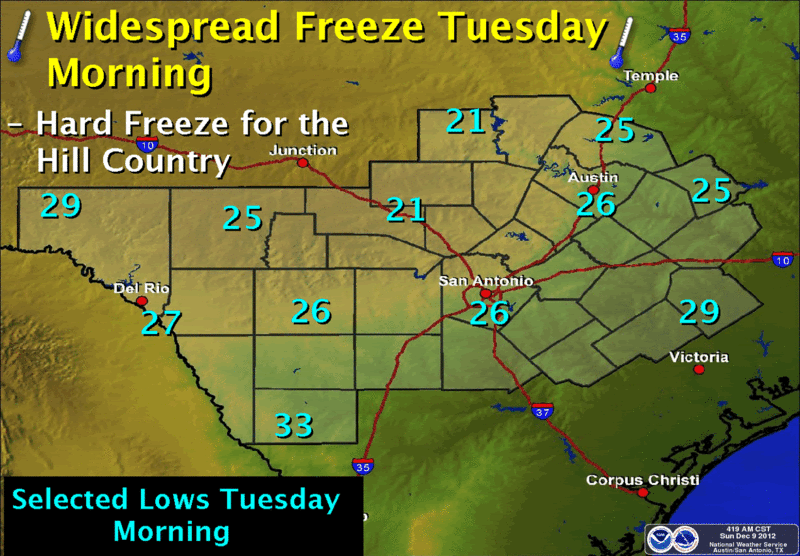
A cold and dry Canadian airmass will overspread the region in the wake of the frontal passage. Clear skies, diminishing winds and low dew-points will result in a widespread freeze Tuesday morning including a hard freeze across the Hill Country. Morning lows will range from the lower to mid 20s across the Hill Country to lower 30s along the Rio Grande.
SPECIAL WEATHER STATEMENT
NATIONAL WEATHER SERVICE AUSTIN/SAN ANTONIO TX
533 AM CST SUN DEC 9 2012
TXZ171>173-183>194-202>209-217>225-228-091900-
LLANO-BURNET-WILLIAMSON-VAL VERDE-EDWARDS-REAL-KERR-BANDERA-
GILLESPIE-KENDALL-BLANCO-HAYS-TRAVIS-BASTROP-LEE-KINNEY-UVALDE-
MEDINA-BEXAR-COMAL-GUADALUPE-CALDWELL-FAYETTE-MAVERICK-ZAVALA-
FRIO-ATASCOSA-WILSON-KARNES-GONZALES-DE WITT-LAVACA-DIMMIT-
INCLUDING THE CITIES OF...LLANO...BURNET...GEORGETOWN...DEL RIO...
ROCKSPRINGS...LEAKEY...KERRVILLE...BANDERA...FREDERICKSBURG...
BOERNE...BLANCO...SAN MARCOS...AUSTIN...BASTROP...GIDDINGS...
BRACKETTVILLE...UVALDE...HONDO...SAN ANTONIO...NEW BRAUNFELS...
SEGUIN...LOCKHART...LA GRANGE...EAGLE PASS...CRYSTAL CITY...
PEARSALL...PLEASANTON...FLORESVILLE...KARNES CITY...GONZALES...
CUERO...HALLETTSVILLE...CARRIZO SPRINGS
533 AM CST SUN DEC 9 2012
...COLD POLAR AIRMASS WILL SWEEP INTO REGION TONIGHT...
A STRONG COLD FRONT WAS POISED JUST SOUTH OF A LUBBOCK...OKLAHOMA
CITY...BARTLESVILLE LINE EARLY THIS MORNING. THE FRONT WILL
CONTINUE SOUTHWARD TODAY PUSHING INTO NORTHERN PORTIONS OF THE
HILL COUNTRY BY THIS EVENING...AND SWEEPING THROUGH ALL OF SOUTH
CENTRAL TEXAS BY MIDNIGHT. AHEAD OF THIS RAPID SHIFT TO WINTER...
ANOTHER MILD TO WARM DAY IS EXPECTED. AFTERNOON HIGHS TODAY WILL
RANGE FROM THE MID TO UPPER 70S OVER THE HILL COUNTRY AND WESTERN
SECTIONS TO THE LOWER 80S GENERALLY ALONG AND EAST OF THE I-35
CORRIDOR.
SCATTERED THUNDERSTORMS MAY DEVELOP ALONG AND AHEAD OF THE COLD
FRONT LATE THIS AFTERNOON AND TONIGHT OVER CENTRAL AND EASTERN
PORTIONS OF SOUTH CENTRAL TEXAS. AS THE COLD FRONT PUSHES INTO
EASTERN PORTIONS THIS EVENING...STRONG TO SEVERE ISOLATED STORMS
MAY DEVELOP...GENERALLY EAST OF THE I=35 CORRIDOR. THE MAIN THREAT
FROM THESE STORMS WILL BE FROM LARGE HAIL.
AS THE STRONG COLD FRONT SWEEPS THROUGH THE REGION...LOWS WILL
PLUNGE TO NEAR OR JUST BELOW FREEZING BY SUNRISE MONDAY ACROSS THE
HILL COUNTRY WITH NEAR 40 ALONG THE I-35 CORRIDOR. BREEZY NORTH
WINDS OF 15 TO 25 MPH WILL ACCOMPANY THE PASSAGE OF THE FRONT AND
COULD INCREASE TO AS HIGH AS 20 TO 30 MPH LATE TONIGHT INTO EARLY
MONDAY MORNING. THE DRY...COLD SURFACE RIDGE WILL CONTINUE
BUILDING INTO THE REGION DURING THE DAY MONDAY WITH NORTH WINDS
DECREASING DURING THE AFTERNOON. AS THE CENTER OF THE DRY SURFACE
RIDGE SETTLES OVER THE AREA TOMORROW NIGHT...CLEAR SKIES AND
DIMINISHING WINDS WILL CAUSE TEMPERATURES TO PLUNGE. BY TUESDAY
MORNING...FREEZING TEMPERATURES WILL ENCOMPASS VIRTUALLY THE
ENTIRE SOUTH CENTRAL TEXAS AREA...WITH READINGS FALLING TO NEAR 20
ACROSS THE HILL COUNTRY AND THE MID TO UPPER 20S ALONG THE I-35
CORRIDOR. UNDER MOSTLY SUNNY SKIES...TUESDAY`S HIGHS WILL ONLY
REACH INTO THE 50S AREA-WIDE...STRUGGLING TO REACH NEAR 50 ACROSS
THE HILL COUNTRY.
THIS COLD WEATHER PATTERN WILL LIKELY LINGER ANOTHER DAY ON WEDNESDAY
BEFORE A RETURN SOUTHERLY FLOW STARTS A BONAFIDE WARMING TREND FOR
THE LATTER PART OF THE WEEK.
PREPARATIONS SHOULD BE MADE NOW FOR THIS PERIOD OF COLD WEATHER.
TENDER VEGETATION AND PETS SHOULD BE PROTECTED. OUTDOOR PIPES
SHOULD ALSO BE WRAPPED...ESPECIALLY IN HILL COUNTRY LOCATIONS WHERE
MANY HOURS OF SUBFREEZING TEMPERATURES ARE EXPECTED.
LISTEN TO NOAA WEATHER RADIO OR YOUR LOCAL MEDIA FOR LATER UPDATES
ON THIS UPCOMING COLD WEATHER EVENT.
0 likes
The following post is NOT an official forecast and should not be used as such. It is just the opinion of the poster and may or may not be backed by sound meteorological data. It is NOT endorsed by any professional institution including storm2k.org For Official Information please refer to the NHC and NWS products.
-
Rgv20
- S2K Supporter
- Posts: 2466
- Age: 39
- Joined: Wed Jan 05, 2011 5:42 pm
- Location: Edinburg/McAllen Tx
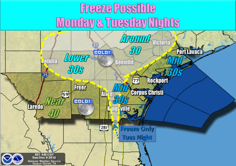
The coldest air of the season thus far will settle into South Texas Monday and Tuesday nights. Clearing skies and light winds will allow temperatures to fall into the 30s in most locations. Across the northern counties, and some southern inland locations, temperatures are forecast to fall to or slightly below the freezing mark.
SPECIAL WEATHER STATEMENT
NATIONAL WEATHER SERVICE CORPUS CHRISTI TX
449 AM CST SUN DEC 9 2012
TXZ229>234-239>247-092200-
LA SALLE-MCMULLEN-LIVE OAK-BEE-GOLIAD-VICTORIA-WEBB-DUVAL-
JIM WELLS-KLEBERG-NUECES-SAN PATRICIO-ARANSAS-REFUGIO-CALHOUN-
INCLUDING THE CITIES OF...COTULLA...CALLIHAM...CROSS...
LOMA ALTA...TILDEN...GEORGE WEST...THREE RIVERS...BEEVILLE...
GOLIAD...VICTORIA...LAREDO...FREER...BENAVIDES...SAN DIEGO...
ALICE...ORANGE GROVE...KINGSVILLE...CORPUS CHRISTI...PORTLAND...
INGLESIDE...ARANSAS PASS...SINTON...MATHIS...ROCKPORT...REFUGIO...
WOODSBORO...PORT LAVACA
449 AM CST SUN DEC 9 2012
...STRONG COLD FRONT TO MOVE THROUGH SOUTH TEXAS TONIGHT INTO
MONDAY MORNING...
ONE MORE DAY OF WELL ABOVE NORMAL TEMPERATURES IS EXPECTED ACROSS
SOUTH TEXAS TODAY. AFTERNOON HIGHS WILL BE IN THE LOWER TO MIDDLE
80S ACROSS THE AREA. HOWEVER...A STRONG COLD FRONT LATE TONIGHT
INTO MONDAY MORNING WILL BRING AN END TO THE RECENT WARM
CONDITIONS.
AFTER SHOWERS AND THUNDERSTORMS ASSOCIATED WITH THE COLD FRONT
MOVE SOUTH OF THE REGION MONDAY MORNING...A MUCH COLDER AND DRIER
AIRMASS WILL FILTER INTO SOUTH TEXAS. AFTERNOON HIGH TEMPERATURES
ON MONDAY WILL BE ON AVERAGE ABOUT 20 TO 30 DEGREES COOLER THAN
TODAY...WITH TEMPERATURES ONLY IN THE 50S. IN ADDITION...STRONG
NORTHERLY WINDS BETWEEN 20 AND 30 MPH WITH OCCASIONAL HIGHER GUSTS
WILL DEVELOP BEHIND THE FRONT ON MONDAY.
TEMPERATURES MAY FALL TO NEAR FREEZING MONDAY NIGHT INTO TUESDAY
MORNING ACROSS THE NORTHERN BRUSH COUNTRY AND VICTORIA CROSSROADS
REGION. CLEAR SKIES AND LIGHT WINDS TUESDAY NIGHT INTO WEDNESDAY
MORNING WILL ALLOW FOR MORE WIDESPREAD FREEZING TEMPERATURES
ACROSS SOUTH TEXAS.
PLEASE STAY TUNED TO NOAA WEATHER RADIO OR YOUR PREFERRED MEDIA
OUTLET FOR LATEST FORECAST INFORMATION CONCERNING THE FIRST
POTENTIAL FREEZE OF THE SEASON.
0 likes
The following post is NOT an official forecast and should not be used as such. It is just the opinion of the poster and may or may not be backed by sound meteorological data. It is NOT endorsed by any professional institution including storm2k.org For Official Information please refer to the NHC and NWS products.
-
gboudx

- S2K Supporter
- Posts: 4090
- Joined: Thu Sep 04, 2003 1:39 pm
- Location: Rockwall, Tx but from Harvey, La
Re:
Tireman4 wrote:I believe the front is crossing DFW as we speak.
DFW NWS agrees with you:
http://www.srh.noaa.gov/graphicast.php?site=fwd&gc=5
0 likes
-
BrokenGlassRepublicn
- Category 1
- Posts: 483
- Joined: Sun Nov 20, 2011 8:07 pm
- Location: Richardson, Texas
Texas Winter 2012-2013
At noon, I have 65.9 degrees and winds SSE at 5.3 mph in Richardson by UTD.
0 likes
Who is online
Users browsing this forum: No registered users and 72 guests