Texas Winter 2012-2013

Winter Weather Discussion

Moderator: S2k Moderators

Forum rules

The posts in this forum are NOT official forecast and should not be used as such. They are just the opinion of the poster and may or may not be backed by sound meteorological data. They are NOT endorsed by any professional institution or STORM2K.

Help Support Storm2K
Message
Author
User avatar
Ntxw
Storm2k Moderator
Storm2k Moderator
Posts: 22788
Joined: Wed Oct 21, 2009 6:34 pm
Location: DFW, Texas

Re:

#1401 Postby Ntxw » Sat Dec 22, 2012 12:28 pm

DonWrk wrote:What exactly will be effecting the north or south track of the low?


Where the cold air is located. The storm rides the leading edge of the front and those immediately behind it gets snow.
0 likes   
The above post and any post by Ntxw is NOT an official forecast and should not be used as such. It is just the opinion of the poster and may or may not be backed by sound meteorological data. It is NOT endorsed by any professional institution including Storm2k. For official information, please refer to NWS products.

  Help support Storm2K!
Help Support Storm2K

User avatar
horselattitudesfarm
Category 1
Category 1
Posts: 315
Joined: Thu Jul 16, 2009 5:55 pm
Location: Asheville, NC (formerly from Dallas, TX)

Re: Texas Winter 2012-2013

#1402 Postby horselattitudesfarm » Sat Dec 22, 2012 1:59 pm

My EYE models are showing winds already blowing back in from the Southeast. A small step in moistening the atmosphere back up. The following map confirms my EYE models with dew points coming back up as you approach the gulf

Image

Uploaded with ImageShack.us
0 likes   

User avatar
Ntxw
Storm2k Moderator
Storm2k Moderator
Posts: 22788
Joined: Wed Oct 21, 2009 6:34 pm
Location: DFW, Texas

#1403 Postby Ntxw » Sat Dec 22, 2012 2:07 pm

Models today continue to converge. The area of the Red River east of Lake Texoma stands the best chance for accumulating snow if the globals are correct. Paris/Texarkana in Texas and Broken Bow, Oklahoma could be measuring the snow as well as far northwestern Louisiana along with central and southern Arkansas. Shifts will be likely as the storm will make way into the Pac NW tomorrow. Other areas between I-40 and I-20 will at least see some light snow Christmas afternoon.

By Wednesday of Next week roughly 70% of the country will be covered in snow, which is well above average which is around 30-40%. Could be one of those situations where Florida and Hawaii are the only states without any snow at all.

Today
Image
0 likes   
The above post and any post by Ntxw is NOT an official forecast and should not be used as such. It is just the opinion of the poster and may or may not be backed by sound meteorological data. It is NOT endorsed by any professional institution including Storm2k. For official information, please refer to NWS products.


  Help support Storm2K!

Help Support Storm2K


User avatar
cheezyWXguy
Category 5
Category 5
Posts: 6108
Joined: Mon Feb 13, 2006 12:29 am
Location: Dallas, TX

Re: Texas Winter 2012-2013

#1404 Postby cheezyWXguy » Sat Dec 22, 2012 2:34 pm

ntxw, do you think the storm track is still likely to be south of what the GFS is suggesting, or has it yet fixed its error of underestimating the speed of the cold air and then retreating it northward?
0 likes   

User avatar
Ntxw
Storm2k Moderator
Storm2k Moderator
Posts: 22788
Joined: Wed Oct 21, 2009 6:34 pm
Location: DFW, Texas

Re: Texas Winter 2012-2013

#1405 Postby Ntxw » Sat Dec 22, 2012 2:44 pm

cheezyWXguy wrote:ntxw, do you think the storm track is still likely to be south of what the GFS is suggesting, or has it yet fixed its error of underestimating the speed of the cold air and then retreating it northward?


Given the snow cover to our north, I do believe so. There is still considerable differences in the short and medium range ensembles in placement of the cold air and moisture return. There is just no way to know how dense this air mass is and how much this storm will dig until it's in the Great Basin. But for now as the NWS is probably doing is using consensus of the globals to make a forecast.
0 likes   
The above post and any post by Ntxw is NOT an official forecast and should not be used as such. It is just the opinion of the poster and may or may not be backed by sound meteorological data. It is NOT endorsed by any professional institution including Storm2k. For official information, please refer to NWS products.


  Help support Storm2K!

Help Support Storm2K


GRAYSONCO.WX
Category 1
Category 1
Posts: 450
Joined: Thu Jan 06, 2011 4:29 pm
Location: Denison, Texas

Re: Texas Winter 2012-2013

#1406 Postby GRAYSONCO.WX » Sat Dec 22, 2012 3:08 pm

SPECIAL WEATHER STATEMENT
NATIONAL WEATHER SERVICE FORT WORTH TX
205 PM CST SAT DEC 22 2012

TXZ091>095-100>107-116>123-231200-
MONTAGUE-COOKE-GRAYSON-FANNIN-LAMAR-YOUNG-JACK-WISE-DENTON-COLLIN-
HUNT-DELTA-HOPKINS-PALO PINTO-PARKER-TARRANT-DALLAS-ROCKWALL-
KAUFMAN-VAN ZANDT-RAINS-
205 PM CST SAT DEC 22 2012

...WINTER WEATHER OUTLOOK FOR DECEMBER 25TH...

A STRONG STORM SYSTEM IS EXPECTED TO MOVE ACROSS THE REGION ON
CHRISTMAS DAY. BASED ON THE LATEST FORECAST DATA...THERE WILL BE A
GOOD CHANCE OF A COLD RAIN ON CHRISTMAS DAY ACROSS NORTH AND
CENTRAL TEXAS. ALONG AND TO THE NORTH OF I-20...ATMOSPHERIC
PROFILES WILL BECOME COLD ENOUGH FOR THE RAIN TO MIX WITH OR
CHANGE OVER TO SNOW DURING THE AFTERNOON AND EVENING HOURS. THE
LATEST MODEL GUIDANCE SUGGESTS SNOWFALL ACCUMULATIONS UP TO 2
INCHES ARE POSSIBLE CHRISTMAS AFTERNOON AND EVENING ALONG AND
NORTH OF A BOWIE TO EMORY LINE. SOUTH OF THIS LINE...LIGHT
ACCUMULATIONS OF SNOW ARE POSSIBLE.

AS THE CHANGE OVER TO SNOW OCCURS...NORTHWEST WINDS ARE EXPECTED
TO INCREASE IN SPEED TO 20 TO 30 MPH. ANY SNOW ACCUMULATIONS
WILL BLOW AROUND IN THESE WINDS...WHICH MAY REDUCE VISIBILITY IF
TRAVELING AFTER SUNSET ON CHRISTMAS DAY.

AS OF THIS AFTERNOON...THE UPPER LEVEL STORM SYSTEM WAS ENTERING
THE PACIFIC NORTHWEST. AT THIS TIME...THERE STILL REMAINS A GREAT
DEAL OF UNCERTAINTY REGARDING THE EXACT TRACK AND ANY ASSOCIATED
WINTRY PRECIPITATION FALLING OVER NORTH TEXAS ON CHRISTMAS DAY. IF
THE TRACK OF THE SYSTEM WERE TO SHIFT FARTHER SOUTH...THE
POTENTIAL FOR HIGHER SNOWFALL ACCUMULATIONS ACROSS THE REGION
WOULD INCREASE AND THE RAIN/SNOW LINE WOULD SHIFT FARTHER TO THE
SOUTH.

IN ADDITION TO THE WINTER PRECIPITATION POTENTIAL...THERE IS ALSO
A THREAT FOR SOME SEVERE STORMS EARLY CHRISTMAS MORNING AND
POSSIBLY INTO THE DAY ON THE 25TH. THE THREAT FOR SEVERE WEATHER
AT THIS TIME IS MAINLY SOUTH OF I-20 AND EAST OF I-35. THE
DETAILS OF THE SEVERE WEATHER POTENTIAL ARE JUST NOW COMING TO
FRUITION AND WILL ALSO BE REFINED OVER THE NEXT FEW DAYS.

BOTTOM LINE...WINTRY PRECIPITATION IS POSSIBLE MAINLY ALONG AND
NORTH OF THE I-20 CORRIDOR FOR THE AFTERNOON AND EVENING HOURS OF
CHRISTMAS DAY. SOME SNOW ACCUMULATIONS UP TO 2 INCHES ARE POSSIBLE
ALONG AND NORTH OF A BOWIE TO EMORY LINE. CHECK BACK FOR THE
LATEST FORECAST UPDATES IN THE COMING DAYS AS THESE DETAILS ARE
VERY LIKELY TO CHANGE WITH FUTURE FORECASTS.
0 likes   

User avatar
wxman57
Moderator-Pro Met
Moderator-Pro Met
Posts: 22981
Age: 67
Joined: Sat Jun 21, 2003 8:06 pm
Location: Houston, TX (southwest)

Re: Texas Winter 2012-2013

#1407 Postby wxman57 » Sat Dec 22, 2012 4:37 pm

12Z GFS and Euro are very similar with the path of the upper low across north TX along the Red River Christmas afternoon. Core of heaviest snow across southern OK (1-2"). Trace amounts down to Dallas (or just north of Dallas). Looks reasonable. I'd say you folks in D-FW have a shot at seeing a few snowflakes Christmas afternoon/evening.
0 likes   

PineyWoods
Tropical Storm
Tropical Storm
Posts: 127
Joined: Sat Feb 03, 2007 3:39 pm
Location: Tyler

Re: Texas Winter 2012-2013

#1408 Postby PineyWoods » Sat Dec 22, 2012 4:50 pm

wxman57 wrote:12Z GFS and Euro are very similar with the path of the upper low across north TX along the Red River Christmas afternoon. Core of heaviest snow across southern OK (1-2"). Trace amounts down to Dallas (or just north of Dallas). Looks reasonable. I'd say you folks in D-FW have a shot at seeing a few snowflakes Christmas afternoon/evening.


Well I hope the track will bring us a few flakes here in Tyler. Would be a nice Christmas gift. :)
0 likes   

User avatar
somethingfunny
ChatStaff
ChatStaff
Posts: 3926
Age: 37
Joined: Thu May 31, 2007 10:30 pm
Location: McKinney, Texas

Re: Texas Winter 2012-2013

#1409 Postby somethingfunny » Sat Dec 22, 2012 5:35 pm

wxman57 wrote:12Z GFS and Euro are very similar with the path of the upper low across north TX along the Red River Christmas afternoon. Core of heaviest snow across southern OK (1-2"). Trace amounts down to Dallas (or just north of Dallas). Looks reasonable. I'd say you folks in D-FW have a shot at seeing a few snowflakes Christmas afternoon/evening.


I want all of you to look at this very carefully and appreciate what a good sign this is. Wxman57 very rarely goes ahead and says we ought to get snow. :D
0 likes   
I am not a meteorologist, and any posts made by me are not official forecasts or to be interpreted as being intelligent. These posts are just my opinions and are probably silly opinions.

User avatar
ravyrn
S2K Supporter
S2K Supporter
Posts: 1000
Age: 42
Joined: Sun Aug 31, 2008 5:10 am
Location: Alderbranch, TX

Re: Texas Winter 2012-2013

#1410 Postby ravyrn » Sat Dec 22, 2012 5:42 pm

NWS FTW has a graphic up:
Image
0 likes   

User avatar
iorange55
Category 5
Category 5
Posts: 2388
Joined: Thu Nov 13, 2008 9:47 pm
Location: Big D

Re: Texas Winter 2012-2013

#1411 Postby iorange55 » Sat Dec 22, 2012 6:46 pm

The way it looks right now; North Texas will see some flakes flying around on Christmas. It does appear the heavy stuff will stay north and head up east into Arkansas, however, things can and probably will change. Once it starts its journey over a land we'll have a better idea.

Just wait and see right now.
0 likes   

User avatar
Ntxw
Storm2k Moderator
Storm2k Moderator
Posts: 22788
Joined: Wed Oct 21, 2009 6:34 pm
Location: DFW, Texas

#1412 Postby Ntxw » Sat Dec 22, 2012 6:55 pm

I feel that if there were significant changes in the models tonight would be it. Just a feeling, if there isn't there likely won't be anything major until we track it real time with about 2-3 days to go. Good thing the short range guidance will soon be useful
0 likes   
The above post and any post by Ntxw is NOT an official forecast and should not be used as such. It is just the opinion of the poster and may or may not be backed by sound meteorological data. It is NOT endorsed by any professional institution including Storm2k. For official information, please refer to NWS products.


  Help support Storm2K!

Help Support Storm2K


gpsnowman
S2K Supporter
S2K Supporter
Posts: 3186
Joined: Fri Jan 07, 2011 10:35 am
Location: Grand Prairie Tx

#1413 Postby gpsnowman » Sat Dec 22, 2012 8:32 pm

Just watched WFAA(Steve Mccauley) report and although his precipitation forecast is still the same, the temps are trending colder. A low of 20 Wed. morning and a high of only 34. Much colder than previous forecasts. Even a low of 22 on Thursday. What ever falls Christmas day might stick around for a day or so.
0 likes   

User avatar
iorange55
Category 5
Category 5
Posts: 2388
Joined: Thu Nov 13, 2008 9:47 pm
Location: Big D

Re: Texas Winter 2012-2013

#1414 Postby iorange55 » Sat Dec 22, 2012 9:53 pm

0z NAM looks like it might be slightly south of the 12z NAM and slightly faster. It's a closer call with the heavier precip inching closer to our area, but still mainly to the east and northeast.
0 likes   

User avatar
Portastorm
Storm2k Moderator
Storm2k Moderator
Posts: 9914
Age: 63
Joined: Fri Jul 11, 2003 9:16 am
Location: Round Rock, TX
Contact:

Re: Texas Winter 2012-2013

#1415 Postby Portastorm » Sat Dec 22, 2012 10:14 pm

If you North Texans want to take a break from analyzing every nook and cranny of the models regarding your possible Christmas storm, and for the rest of us looking for hope for the upcoming winter, check out Larry Cosgrove's latest. It's bound to bring a smile to *most* of your faces. :wink:

http://www.examiner.com/article/weatheramerica-newsletter-saturday-december-22-2012-at-7-30-p-m-ct-part-1

http://www.examiner.com/article/weatheramerica-newsletter-saturday-december-22-2012-at-7-30-p-m-ct-part-2
0 likes   
Any forecasts under my name are to be taken with a grain of salt. Get your best forecasts from the National Weather Service and National Hurricane Center.

User avatar
Cuda17
S2K Supporter
S2K Supporter
Posts: 85
Age: 48
Joined: Mon Jan 03, 2011 5:03 pm
Location: Bellville, TX

Re: Texas Winter 2012-2013

#1416 Postby Cuda17 » Sat Dec 22, 2012 10:31 pm

:uarrow:

Ummm.... yeah!!!! Cool!!!!! (sorry didn't know how else to express myself after reading those two pages of pure awesomeness!!!!)
0 likes   
Personal Forecast Disclaimer:
The posts in this forum are NOT official forecast and should not be used as such. They are just the opinion of the poster and may or may not be backed by sound meteorological data. They are NOT endorsed by any professional institution or storm2k.org. For official information, please refer to the NHC and NWS products.

User avatar
iorange55
Category 5
Category 5
Posts: 2388
Joined: Thu Nov 13, 2008 9:47 pm
Location: Big D

Re: Texas Winter 2012-2013

#1417 Postby iorange55 » Sat Dec 22, 2012 10:55 pm

Arkansas continues to be the favorite to pick up heavy snowfall, at least with this storm system. Still time to change, though! Plus, we should have a few more chances this winter :wink:
0 likes   

User avatar
Rgv20
S2K Supporter
S2K Supporter
Posts: 2466
Age: 39
Joined: Wed Jan 05, 2011 5:42 pm
Location: Edinburg/McAllen Tx

#1418 Postby Rgv20 » Sat Dec 22, 2012 11:41 pm

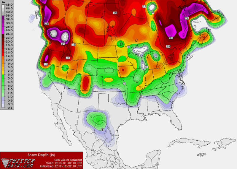
18zGFS Forecast Snowfall to start the New Year.....Its way out in La La Land but when the GFS forecast snow for my area I gotta post it!! :lol:

Image
0 likes   
The following post is NOT an official forecast and should not be used as such. It is just the opinion of the poster and may or may not be backed by sound meteorological data. It is NOT endorsed by any professional institution including storm2k.org For Official Information please refer to the NHC and NWS products.

User avatar
somethingfunny
ChatStaff
ChatStaff
Posts: 3926
Age: 37
Joined: Thu May 31, 2007 10:30 pm
Location: McKinney, Texas

Re: Texas Winter 2012-2013

#1419 Postby somethingfunny » Sat Dec 22, 2012 11:48 pm

:uarrow: Why does the GFS seem to nail the Big Bend and dust the Rio Grande at long range so... fairly often? :P

NWS Fort Worth, 10pm Update wrote:THIS COLD AIR WILL NOT BE VERY DEEP ON MONDAY AND IS LIKELY TO BE
MIXED OUT TO SOME DEGREE IN RESPONSE TO INCREASING SOUTHERLY
WINDS AHEAD OF OUR NEXT SYSTEM OF INTEREST...WHICH WILL BE THE
CHRISTMAS DAY STORM. THERE IS SIGNIFICANT INTEREST IN THIS SYSTEM
FOR ITS POTENTIAL TO PRODUCE SOME HEAVY WINTRY PRECIP TOTALS
ACROSS PARTS OF THE SOUTHERN PLAINS AND MID SOUTH. AS IS OFTEN THE
CASE IN NORTH TEXAS HOWEVER...THE EXACT TRACK HAS MAJOR IMPACTS TO
PRECIPITATION TYPE ACROSS OUR AREA. A LOOK AT SEVERAL ANALOGS TO
THE CONSENSUS FORECAST FOR EARLY TUESDAY MORNING YIELDED A HANDFUL
OF EVENTS WITH SIMILAR SYNOPTIC SETUPS. ONE EVENT IN PARTICULAR
STANDS OUT FOR ITS STRIKING SIMILARITIES TO THE CURRENT FORECAST
PATTERN.
IN EARLY DECEMBER 1989 A STRONG DISTURBANCE ENTERED THE
PACIFIC NORTHWEST MOVED SOUTHEAST ACROSS THE GREAT BASIN BEFORE
DIGGING ACROSS WEST TEXAS AND EVENTUALLY MOVING OVER NORTH TEXAS.
THIS SYSTEM DUG SLIGHTLY FARTHER SOUTH THAN THE CURRENT SYSTEM IS
FORECAST...HOWEVER SIMILAR SURFACE FEATURES DEVELOPED ACROSS
SOUTHEAST TEXAS BEFORE QUICKLY MOVING TO THE NORTHEAST. THE BULK
OF THE PRECIPITATION WAS LOCATED ACROSS EAST TEXAS AND LOUISIANA
WITH WRAP AROUND WINTRY PRECIP PRIMARILY ACROSS OKLAHOMA. THE ONE
DIFFERENCE WITH THIS SYSTEM...WAS SURFACE TEMPERATURES WERE
SEVERAL DEGREES WARMER THAN CURRENTLY FORECAST. SEVERAL OF THE
OTHER ANALOGS WITH SLIGHT DIFFERENCES IN TRACKS OF THE MAIN UPPER
TROUGHS YIELDED SIMILAR RESULTS. THIS INCREASES CONFIDENCE IN THE
CURRENT FORECAST OF PRIMARILY RAIN DEVELOPING INITIALLY AND MOVING
NORTHEAST WITH THE MAIN SURFACE LOW...AND A CHANGEOVER TO SOME
SNOW ON THE BACK SIDE OF THE SYSTEM. THE CURRENT FORECAST HANDLES
THIS WELL...AND FORECAST SOUNDINGS STILL SUPPORT A CHANGEOVER TO
SNOW ON CHRISTMAS AFTERNOON/EVENING AS THE COLDER AIR FILTERS IN.

WITH SUCH A FAST MOVING SYSTEM...AND STRONG WESTERLY WINDS ALOFT...
A SIGNIFICANT DRY SLOT WILL ADVANCE EASTWARD ON CHRISTMAS DAY AS
THE SYSTEM DEEPENS. THIS SHOULD ALLOW FOR A SHARP PRECIPITATION
GRADIENT ON THE BACK SIDE OF THE LOW AND FROM NORTH TO SOUTH WHERE
ANY WINTRY PRECIPITATION SHOULD OCCUR. THE CURRENT MENTION OF
NORTH OF THE I-20 CORRIDOR LOOKS GOOD FOR ANY POSSIBLE SNOW DURING
THE DAY ON TUESDAY.


THEY SAID 1989!!!!!! :eek:
0 likes   
I am not a meteorologist, and any posts made by me are not official forecasts or to be interpreted as being intelligent. These posts are just my opinions and are probably silly opinions.

User avatar
Ntxw
Storm2k Moderator
Storm2k Moderator
Posts: 22788
Joined: Wed Oct 21, 2009 6:34 pm
Location: DFW, Texas

Re: Texas Winter 2012-2013

#1420 Postby Ntxw » Sat Dec 22, 2012 11:51 pm

somethingfunny wrote:THEY SAID 1989!!!!!! :eek:


Early December 1989, there was a lesser cold snap than the late month one :wink:
0 likes   
The above post and any post by Ntxw is NOT an official forecast and should not be used as such. It is just the opinion of the poster and may or may not be backed by sound meteorological data. It is NOT endorsed by any professional institution including Storm2k. For official information, please refer to NWS products.


  Help support Storm2K!

Help Support Storm2K


Return to “Winter Weather”

Who is online

Users browsing this forum: No registered users and 3 guests