Texas Winter 2012-2013
Moderator: S2k Moderators
Forum rules
 The posts in this forum are NOT official forecast and should not be used as such. They are just the opinion of the poster and may or may not be backed by sound meteorological data. They are NOT endorsed by any professional institution or STORM2K.

The posts in this forum are NOT official forecast and should not be used as such. They are just the opinion of the poster and may or may not be backed by sound meteorological data. They are NOT endorsed by any professional institution or STORM2K.
-
TrekkerCC

- S2K Supporter

- Posts: 263
- Joined: Sat Sep 06, 2003 10:19 pm
- Location: North Central Texas (Dallas Area)
Re: Texas Winter 2012-2013
Merry Christmas Eve, Everyone! Portastorm, very nice post! I do hope we get a surprise tomorrow! But even if we only get a few,snowflakes, it will be worth it to have a White Christmas!
0 likes
Storm2K Forecast Disclaimer:
This post is NOT AN OFFICIAL FORECAST and should not be used as such. It is just the opinion of the poster and may or may not be backed by sound meteorological data. It is NOT endorsed by any professional institution including storm2k.org. For Official Information please refer to the NHC and NWS products.
This post is NOT AN OFFICIAL FORECAST and should not be used as such. It is just the opinion of the poster and may or may not be backed by sound meteorological data. It is NOT endorsed by any professional institution including storm2k.org. For Official Information please refer to the NHC and NWS products.


Re: Texas Winter 2012-2013
After 10+ days of intense model watching, we are now down to our last set of runs before the event unfolds. Leading edge of the shortwave is now approaching the southern AZ/NM border and we can see a thin line of showers breaking out in West Texas in response.

0 likes
The above post and any post by Ntxw is NOT an official forecast and should not be used as such. It is just the opinion of the poster and may or may not be backed by sound meteorological data. It is NOT endorsed by any professional institution including Storm2k. For official information, please refer to NWS products.
Help support Storm2K!

NAM is really cranking it. Heavy snow falling along and north of I-20 especially to the Red River. Wet bulbing and a lot of moist air advection

Last edited by Ntxw on Mon Dec 24, 2012 9:04 pm, edited 2 times in total.
0 likes
The above post and any post by Ntxw is NOT an official forecast and should not be used as such. It is just the opinion of the poster and may or may not be backed by sound meteorological data. It is NOT endorsed by any professional institution including Storm2k. For official information, please refer to NWS products.
Help support Storm2K!
Help support Storm2K!
-
GRAYSONCO.WX
- Category 1

- Posts: 450
- Joined: Thu Jan 06, 2011 4:29 pm
- Location: Denison, Texas
Re: Texas Winter 2012-2013
Anybody notice the cooler temperatures, which lie across north Texas? Example: 37 in Gainesville; expected low of 39
EDIT: now 36
EDIT: now 36
0 likes
-
aggiecutter
- Category 5

- Posts: 1755
- Joined: Thu Oct 14, 2004 9:22 pm
- Location: Texarkana
Re: Texas Winter 2012-2013
The 0z NAM is about 50-70 miles further south with its snowfall accumulations than the 12z and 18z runs.
http://www.twisterdata.com/index.php?pr ... hive=false
http://www.twisterdata.com/index.php?pr ... hive=false
0 likes
Keep an eye on the deformation band, if the low gets cranking faster than expected there will be a lot of dynamic cooling involved.
0 likes
The above post and any post by Ntxw is NOT an official forecast and should not be used as such. It is just the opinion of the poster and may or may not be backed by sound meteorological data. It is NOT endorsed by any professional institution including Storm2k. For official information, please refer to NWS products.
Help support Storm2K!
Help support Storm2K!
-
aggiecutter
- Category 5
- Posts: 1755
- Joined: Thu Oct 14, 2004 9:22 pm
- Location: Texarkana
Re: Texas Winter 2012-2013
0z NAM snowfall totals. Texarkana and the DFW metroplex project to get over 2".
http://raleighwx.americanwx.com/models/ ... _SP036.gif
http://raleighwx.americanwx.com/models/ ... _SP036.gif
0 likes
-
GRAYSONCO.WX
- Category 1
- Posts: 450
- Joined: Thu Jan 06, 2011 4:29 pm
- Location: Denison, Texas
Re: Texas Winter 2012-2013
000
FXUS64 KFWD 250312
AFDFWD
AREA FORECAST DISCUSSION
NATIONAL WEATHER SERVICE FORT WORTH TX
912 PM CST MON DEC 24 2012
.UPDATE...
WE HAVE ANALYZED THE 00Z UPPER AIR DATA AND HAVE WATCHED THE
SURFACE OBS CLOSELY FOR SIGNS OF ANY DISCREPANCIES BETWEEN THEM
AND THE MODEL DATA. THE BIG THING THAT STANDS OUT ARE THAT THE
SURFACE LOW IN NORTHEAST NEW MEXICO AT 6PM WAS ABOUT 80 MILES
FARTHER SOUTH THAN ALL OF THE MODELS HAD FORECAST 24 HOURS AGO.
WHEN DEALING WITH A SWINGING/DIGGING UPPER LEVEL SYSTEM...THE
SURFACE PRESSURE PATTERN AND PRESSURE TENDENCIES OFFER ENORMOUS
CLUES ON THE FUTURE TRACK OF A POTENTIAL VORTICITY ANOMALY BEFORE
IT CLOSES OFF TO BECOME A FULL FLEDGED UPPER LOW. THE 3PM AND 6PM
SURFACE ANALYSIS SHOWED A LARGE REGION OF PRESSURE FALLS ACROSS
NEW MEXICO AND WEST TEXAS IN ADVANCE OF THE SYSTEM. GIVEN THE
ORIENTATION OF THE PRESSURE FALLS AND LOCATION OF THE SURFACE
LOW...IT CAN BE DETERMINED WITHOUT EVEN LOOKING AT A FORECAST
MODEL THAT THE UPPER LOW HAS NOT FINISHED DIGGING SOUTH. THE BIG
QUESTION IS HOW FAR SOUTH WILL THE UPPER LOW MAKE IT BEFORE IT
BEGINS TO SWING BACK TO THE NORTHEAST. AT THIS HOUR PRESSURE FALLS
CONTINUE IN THE REGION FROM LUBBOCK TO MIDLAND...WITH ANOTHER
PRESSURE FALL AREA DEVELOPING IN SOUTHEAST TEXAS. EXTRAPOLATING
SUGGESTS THE UPPER LOW WILL TRACK JUST SOUTH OF LUBBOCK BY SUNRISE
AND TO NEAR WACO BY SUNSET. AS THE LOW APPROACHES WACO...A WARM
FRONT WILL BE ORGANIZING OUT OF THE WEAK STATIONARY FRONT
CURRENTLY ANALYZED FROM SAN ANTONIO TO HOUSTON. BAROCLINIC QG
THEORY SUGGESTS THAT ONCE LOW LEVEL WARM ADVECTION BEGINS IN
EARNEST ACROSS SOUTHEAST TEXAS BY MORNING...IT WILL INDUCE HEIGHT
RISES TO THE SOUTHEAST OF OUR UPPER LOW WHICH WILL CAUSE THE LOW
TO CLOSE OFF AND FINISH DIGGING SOUTH...AND START ITS GRADUAL
TURN TO THE NORTHEAST. TOMORROW EVENING I WOULD EXPECT THE LOW TO
TRACK FROM NEAR WACO TO NEAR SHREVEPORT. IN SUMMARY THE USUAL
MEDIUM RANGE MODELS APPEAR TO BE A LITTLE TOO FAR NORTH WITH THE
TRACK OF THE UPPER LOW. OUR EXPECTATIONS FOR THE TRACK OF THE LOW
ALIGN WELL WITH THE RAP FORECAST WHICH IS TO THE SOUTH OF ALL
OTHER MODELS...SO WE WILL USE THE RAP HEAVILY.
OUR FORECAST HAS BEEN ON THE SOUTHERLY SIDE AND SNOWIER SIDE OF
THE MODEL GUIDANCE. SO ALTHOUGH WE ARE SEEING AN EVEN MORE
SOUTHERLY TRACK COME TO FRUITION...THIS DOES NOT NECESSARILY
MEAN THE FORECAST SNOW AMOUNTS NEED TO BE AMENDED MUCH. THIS IS IN
PART DUE TO THE DIFFICULTY IN GETTING THE COLDER/SUBFREEZING AIR
FARTHER SOUTH BEFORE THE PRECIPITATION ENDS. THE EXCEPTION IS THE
NORTHWEST ZONES WHERE THE MORE SOUTHERLY TRACK SUGGESTS MORE
PRECIP WILL FALL IN SUBFREEZING AIR. DUE TO THE TERRAIN EFFECTS
HERE...COLD AIR HAS AN EASY TIME GETTING INTO OUR NORTHWEST ZONES
WHEN WE HAVE A NORTH/NORTHEAST SURFACE WIND. HAVE EXPANDED THE
SNOW ADVISORY TO INCLUDE YOUNG/JACK/WISE COUNTIES...AND HAVE
INCREASED SNOW TOTALS TO THE 2-4 INCH RANGE FROM BOWIE TO SHERMAN.
THE NORTHEAST ZONES LIKELY WONT SWITCH TO SNOW UNTIL LATE
AFTERNOON...AS COLD AIR WILL HAVE TROUBLE MOVING IN AT THE SURFACE
DUE TO THE LEE SHADOW WARMING EFFECT OF THE OZARK PLATEAU. MOST OF
THE SNOW THAT OCCURS THERE WILL BE AFTER 6 PM AND WILL BE HIGHLY
DEPENDENT ON WHETHER MESOSCALE BANDING CAN SET UP IN THE WAKE OF
THE UPPER LOW. THE NEW NAM HAS FINALLY FORECAST SOME SIGNIFICANT
BANDING TO OCCUR...THUS WILL LEAVE THE ADVISORY ALONE IN THIS
AREA...BUT CONFIDENCE IS A LITTLE LOWER IN THE NORTHEAST ZONES FOR
2+ INCHES OF SNOW.
FARTHER TO THE SOUTH OF THE ADVISORY...FOR THE I-20 CORRIDOR AND
INCLUDING THE METROPLEX...THERE IS NOW HIGH CONFIDENCE THAT SNOW
WILL OCCUR. HOWEVER ALL INDICATIONS ARE THAT IT WILL STILL BE A
BRIEF 1-3 HOUR EVENT WITH NOT ENOUGH TIME TO GET ACCUMULATIONS
OVER AN INCH. IT MUST BE STRESSED THAT WITH TEMPERATURES FALLING
INTO THE 20S BY SUNSET...ANY APPRECIABLE MOISTURE REMAINING ON
BRIDGES...OVERPASSES AND EVEN SURFACE STREETS WILL LIKELY RE-
FREEZE INTO BLACK ICE. ALTHOUGH WE ARE USING 1+ INCH AS CRITERIA
FOR THE COUNTIES IN THE WINTER WEATHER ADVISORY AREA...WE MAY
EXPAND THE ADVISORY SOUTH INTO THE METROPLEX OVERNIGHT DUE SOLELY
TO TRAVEL IMPACTS.
0 likes
GFS has half a foot of snow around Lake Texoma and 10+ inches near Paris and over a foot (15+) near Ardmore, Ok
Edit: I was looking at the wrong map, still a lot of snow just take a couple inches of those ^
Edit: I was looking at the wrong map, still a lot of snow just take a couple inches of those ^
Last edited by Ntxw on Mon Dec 24, 2012 10:52 pm, edited 2 times in total.
0 likes
The above post and any post by Ntxw is NOT an official forecast and should not be used as such. It is just the opinion of the poster and may or may not be backed by sound meteorological data. It is NOT endorsed by any professional institution including Storm2k. For official information, please refer to NWS products.
Help support Storm2K!
Help support Storm2K!
-
Rgv20

- S2K Supporter
- Posts: 2466
- Age: 39
- Joined: Wed Jan 05, 2011 5:42 pm
- Location: Edinburg/McAllen Tx
My sister in Denton might be in for a surprise tomorrow afternoon!
0zGFS Snow Forecast Totals thru 36hrs..
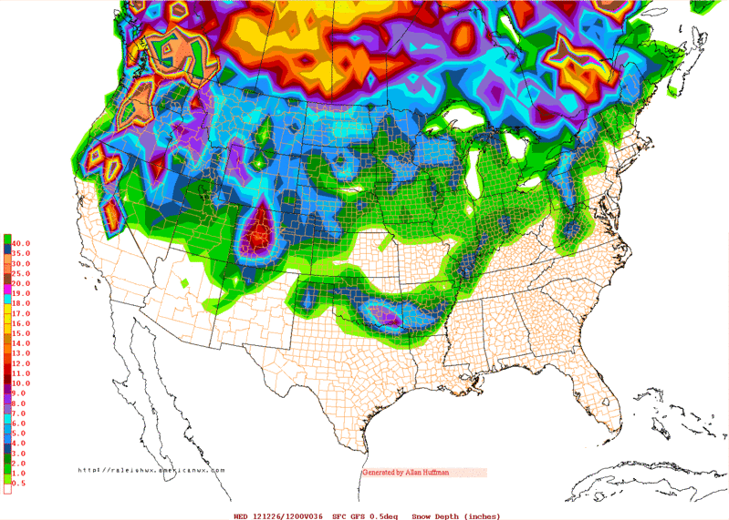
0zGFS Snow Forecast Totals thru 36hrs..
0 likes
The following post is NOT an official forecast and should not be used as such. It is just the opinion of the poster and may or may not be backed by sound meteorological data. It is NOT endorsed by any professional institution including storm2k.org For Official Information please refer to the NHC and NWS products.
Re: Texas Winter 2012-2013
Here is the 0z NAM using the 10:1 ratio method.

RAP continues to be the furthest south and west giving areas near Abilene some accumulating snow
RAP continues to be the furthest south and west giving areas near Abilene some accumulating snow
0 likes
The above post and any post by Ntxw is NOT an official forecast and should not be used as such. It is just the opinion of the poster and may or may not be backed by sound meteorological data. It is NOT endorsed by any professional institution including Storm2k. For official information, please refer to NWS products.
Help support Storm2K!
Help support Storm2K!

Re: Texas Winter 2012-2013
This storm could be a real surprise for a lot of folks. Reminds me of another storm we had not too long ago... 
We're now in the period of "real time" watching!
We're now in the period of "real time" watching!
0 likes

-
TeamPlayersBlue

- Category 5
- Posts: 3524
- Joined: Tue Feb 02, 2010 1:44 am
- Location: Denver/Applewood, CO
According to that NS, things are looking better for you guys. Much of my family lives out of state so im pretty much having the evening to myself!!! Might stay up and watch the storm develop. Maybe now is a good time to post some links of satellites etc so we can watch the storm come to fruition. Hope you guys get some snow tongiht!
0 likes
Personal Forecast Disclaimer:
The posts in this forum are NOT official forecast and should not be used as such. They are just the opinion of the poster and may or may not be backed by sound meteorological data. They are NOT endorsed by any professional institution or storm2k.org. For official information, please refer to the NHC and NWS products.
The posts in this forum are NOT official forecast and should not be used as such. They are just the opinion of the poster and may or may not be backed by sound meteorological data. They are NOT endorsed by any professional institution or storm2k.org. For official information, please refer to the NHC and NWS products.
-
coltsfan90
- Tropical Wave

- Posts: 4
- Joined: Sun Dec 23, 2012 6:14 pm
-
aggiecutter
- Category 5
- Posts: 1755
- Joined: Thu Oct 14, 2004 9:22 pm
- Location: Texarkana
Re: Texas Winter 2012-2013
Winter Weather Advisory
URGENT - WINTER WEATHER MESSAGE...UPDATED
NATIONAL WEATHER SERVICE SHREVEPORT LA
957 PM CST MON DEC 24 2012
...SNOW ACCUMULATIONS POSSIBLE LATE ON CHRISTMAS DAY THROUGH
TUESDAY NIGHT ALONG I-30 CORRIDOR...
ARZ070-TXZ096-097-108>112-251200-
/O.EXA.KSHV.WW.Y.0002.121225T2100Z-121226T0600Z/
MILLER-RED RIVER-BOWIE-FRANKLIN-TITUS-CAMP-MORRIS-CASS-
INCLUDING THE CITIES OF...TEXARKANA...CLARKSVILLE...MT VERNON...
MT PLEASANT...PITTSBURG...DAINGERFIELD...ATLANTA
957 PM CST MON DEC 24 2012
...WINTER WEATHER ADVISORY IN EFFECT FROM 3 PM TUESDAY TO
MIDNIGHT CST TUESDAY NIGHT...
THE NATIONAL WEATHER SERVICE IN SHREVEPORT HAS ISSUED A WINTER
WEATHER ADVISORY FOR SNOW...WHICH IS IN EFFECT FROM 3 PM ON
CHRISTMAS DAY TO MIDNIGHT CST TUESDAY NIGHT.
* EVENT...A POWERFUL STORM SYSTEM WILL MOVE INTO THE REGION ON
CHRISTMAS DAY...BRINGING ACCUMULATING SNOW TO THE I-30 CORRIDOR
LATE ON CHRISTMAS DAY THROUGH TUESDAY NIGHT. SNOWFALL
ACCUMULATIONS OF ONE TO THREE INCHES WILL BE POSSIBLE ACROSS THE
ADVISORY AREA THROUGH TUESDAY NIGHT.
* TIMING...RAIN WILL BEGIN TO TRANSITION TO A WINTRY MIX BY MID
AFTERNOON TUESDAY. THE PRECIPITATION WILL TRANSITION TO ALL SNOW
LATE TUESDAY AFTERNOON OVER SOUTHEAST OKLAHOMA...NORTHEAST TEXAS AND
ADJACENT SECTIONS OF SOUTHWEST ARKANSAS...AND WILL CONTINUE
THROUGH TUESDAY NIGHT.
* IMPACT...MANY ROADWAYS MAY BECOME HAZARDOUS DUE TO SNOW
ACCUMULATIONS AND POSSIBLY ICE IF PREVIOUS RAIN WATER AND
MELTED SNOW REFREEZES.
0 likes
Don't worry, we'll have plenty of real time watch in the morning. It will mostly be all rain through the night sprouting in central and southeast Texas. Most of the snow from this storm won't get going until late morning when the low tightens up near Waco or just south and lifts those storms north/northwest into a deformation band. We'll be awake to see it happen!
0 likes
The above post and any post by Ntxw is NOT an official forecast and should not be used as such. It is just the opinion of the poster and may or may not be backed by sound meteorological data. It is NOT endorsed by any professional institution including Storm2k. For official information, please refer to NWS products.
Help support Storm2K!
Help support Storm2K!
Re:
Ntxw wrote:Don't worry, we'll have plenty of real time watch in the morning. It will mostly be all rain through the night sprouting in central and southeast Texas. Most of the snow from this storm won't get going until late morning when the low tightens up near Waco or just south and lifts those storms north/northwest into a deformation band. We'll be awake to see it happen!
Ah, presents, Atlantic grilled salmon, mint chocolate chip ice cream and model watching. Sounds like the best Christmas morning a nerd could ask for.
0 likes
Re: Re:
iorange55 wrote:Ah, presents, Atlantic grilled salmon, mint chocolate chip ice cream and model watching. Sounds like the best Christmas morning a nerd could ask for.
Let the cowboys beat the redskins next Sunday night and it could be one of the best Christmas week ever!
0 likes
The above post and any post by Ntxw is NOT an official forecast and should not be used as such. It is just the opinion of the poster and may or may not be backed by sound meteorological data. It is NOT endorsed by any professional institution including Storm2k. For official information, please refer to NWS products.
Help support Storm2K!
Help support Storm2K!
Who is online
Users browsing this forum: Brazoria979cnty and 52 guests