With regards to the SSW and other factors, I have some questions (to Ntxw):
1. What values was the AO during January and then into February 1985? A link to past AO records?
2. I read on the weather centre's blog with its excellent in-depth analysis on the coming cold talking mostly about the SSW, that the Polar Vortex has to remain in some form to prevent the atmosphere from becoming "chaos"...what does that actually mean?
Link to Fantastic Polar Vortex Collapse News: http://theweathercentre.blogspot.caNtxw wrote:Right now the models do not show historic cold of any kind, very cold yes. However there is the remote possibility the SSW will pop the -EPO ridge sending even higher heights to Alaska, if that happens then we can talk historic. Still a remote chance
Kennethb wrote:While I am all in favor of some decent cold. Just remember two years ago when both of the "reliable" models showed a 1050+ high building down the plains in the 6-7 day outlook and it just did not happen. Even some of the more conservative mets were acknowledging an arctic pluge. Perhaps this time will be different.
It depends on where you are. Some get it some don't. The East coast this time is at risk from the SE ridge that will block any strong cold air intrusion
Yeah I don't like the sound of this, I rather record-breaking cold then just very cold since there is nothing good with the latter...at least the former is "interesting" and "new". If it is very dry as well then its the worst possible pattern.
orangeblood wrote:Another note to give you an idea of the kind of cold that this pattern could tap into and lock in over North America....the snow cover for last month in the Northern Hemisphere just set the December all time record. The record it just broke was back in.......................December of 1984!! Preceding the historic outbreak of January of 1985

Yet another similarity, crap. Strangely enough, I checked some records for January 1985 around the GL areas and it wasn't all that cold...not as cold as January 2004 at least so I have no clue as to what made it warmer...the lakes?
SaskatchewanScreamer wrote:Quit it!

Do NOT hope, dream, or pray for cold.........because if we get the FULL MONTY of Old Man Winter I WILL be sending him down and he is NOT a pretty sight. He is OLD, MEAN and UGLY and he will be your worst nightmare!!!
Please DO NOT tempt him!
No use posting this in this thread, I did and had posts beginning with "No Offence" a few times

. What I don't get is any negative response is never pointed at you...they must be used to you
.
Portastorm wrote:I would never tempt Old Man Winter.
Well, only on days that end in "y." 
Nice one
.
Kludge wrote:One thing to watch to see if the "experts" are really buying into this is to follow the money. The futures markets listen to their hired-gun forecasters, and invest accordingly. Natural gas futures have been dropping steadily over the past weeks and months. If this starts to look like the real deal, watch them spike.
Good tip, I didn't even think of that.
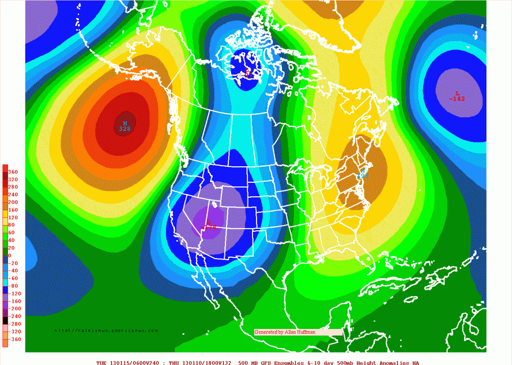
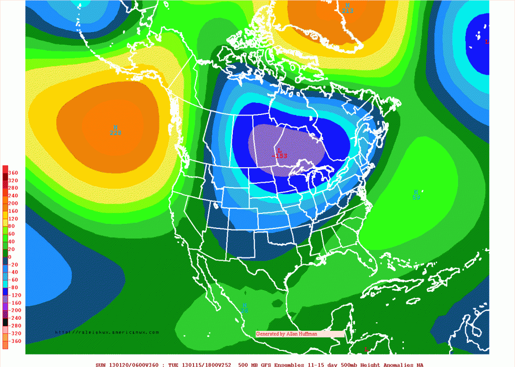
Ntxw wrote:orangeblood wrote:Along with the X-Factor in this setup - the Major SSW occurring now, It's hard to ignore the similarities to 1985 though....just look at the 500 mb Northern Hemisphere pattern for January of 1985 to the GFS ensemble long range forecast in the 10-15 day range
I'm not certain on this but most of the major blasts probably happened the same way regarding SSW.
The thing about 1985 and what the models are forecasting has subtle differences which makes a big difference. 1985 was very +PNA/extreme -NAO induced. Noticed the insane anomalies over Greenland. This essentially glides the high pressure southeast and Texas got glancing blows.
Core of the cold was over the Lakes and northeast/mid-atlantic.The second anomaly map is -EPO dominated with the -PNA which will slide the high down the west and central conus much like the other -EPO dominated periods of 83 and 89. This is if forecasting holds. I haven't yet seen the 564+ dm's over Greenland to point towards 1985
I like to use this site for analog patterns
http://www.hpc.ncep.noaa.gov/ncepreanal/
To the bolded part, eariler in this post I mentioned how it was actually not that bad in the Great Lakes based on the climate data I checked (below average but not crazy cold), and that link shows the PV fairly close to the locations checked...odd. For example, January 2004 was much colder than January 1985 for mid-western Ontario. That's a good link though, I wish it went back further so I could check February 1899, February 1934, and January 1935. The coldest temperature in Ontario's history was −58.3 °C (−73 °F) set in Iroquois Falls on January 23, 1935.
SaskatchewanScreamer wrote:Please put me out of my misery and tell me what those maps are saying the temperature will be over my location.
To quote one of the Joplin convenience store tornado survivors from that video, this s*** is getting real. 1062 mb high from the Canadian is this model showing its true colours, it likes the cold!
SaskatchewanScreamer wrote:Now it will be a race between me and Nick to see who gets to Jamaica first.
It'll be a race between how fast you can put the fire wood in the stove and how cold the house will get
. I haven't checked the Canadian thread yet but I have a feeling Nick is more then not okay with this

.
Nicko999 wrote:Actually we never get as cold as Saskatchewan so go ahead and feel free to leave
... Looking at the models... the cold will not be as strong by the time it comes here.
I think SS knows this, referring to just very cold weather bothering you more because even if its not -50ºC in Montreal, you still wouldn't like the coldest your region can give you.
 The posts in this forum are NOT official forecast and should not be used as such. They are just the opinion of the poster and may or may not be backed by sound meteorological data. They are NOT endorsed by any professional institution or