Texas Winter 2012-2013
Moderator: S2k Moderators
Forum rules
 The posts in this forum are NOT official forecast and should not be used as such. They are just the opinion of the poster and may or may not be backed by sound meteorological data. They are NOT endorsed by any professional institution or STORM2K.

The posts in this forum are NOT official forecast and should not be used as such. They are just the opinion of the poster and may or may not be backed by sound meteorological data. They are NOT endorsed by any professional institution or STORM2K.
-
orangeblood
- S2K Supporter

- Posts: 3895
- Joined: Tue Dec 15, 2009 6:14 pm
- Location: Fort Worth, TX
Re: Texas Winter 2012-2013
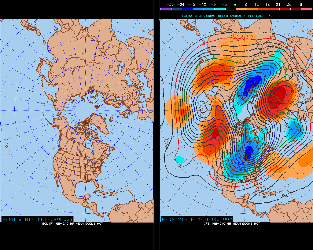
Looks like the Siberian Express tracks are being laid down....toot toot!! You don't see a 8-10 day 500 mb mean height map quite like this every winter
0 likes
-
GaryHughes

- S2K Supporter
- Posts: 88
- Joined: Tue Dec 18, 2012 12:39 am
- Location: Parker County, near Springtown
Re: Texas Winter 2012-2013
orangeblood wrote:Looks like the Siberian Express tracks are being laid down....toot toot!! You don't see a 8-10 day 500 mb mean height map quite like this every winter
Time to get the firewood stocked up, looking as though we will all need it sooner than later!
0 likes
The above post and any post by GaryHughes is NOT an official forecast and should not be used as such. It is just the opinion of the poster and may or may not be backed by sound meteorological data. It is NOT endorsed by any professional institution including storm2k.org. For official information, please refer to NWS products.

Re: Texas Winter 2012-2013
orangeblood wrote:Looks like the Siberian Express tracks are being laid down....toot toot!! You don't see a 8-10 day 500 mb mean height map quite like this every winter
You don't see a map like that any winter
0 likes
The above post and any post by Ntxw is NOT an official forecast and should not be used as such. It is just the opinion of the poster and may or may not be backed by sound meteorological data. It is NOT endorsed by any professional institution including Storm2k. For official information, please refer to NWS products.
Help support Storm2K!
-
Rgv20

- S2K Supporter
- Posts: 2466
- Age: 39
- Joined: Wed Jan 05, 2011 5:42 pm
- Location: Edinburg/McAllen Tx
Just for fun 12zGFS 11-15 days 850mb Temperature Anomalies... 

0 likes
The following post is NOT an official forecast and should not be used as such. It is just the opinion of the poster and may or may not be backed by sound meteorological data. It is NOT endorsed by any professional institution including storm2k.org For Official Information please refer to the NHC and NWS products.
Not getting a lot of attention, the California valley growers are threatened this weekend with the cold snap over the west. May frost into the Napa Valley near San Francisco and hard freezes into Sacramento. Will Texas' rio grande and Florida's citrus industries be next? 

0 likes
The above post and any post by Ntxw is NOT an official forecast and should not be used as such. It is just the opinion of the poster and may or may not be backed by sound meteorological data. It is NOT endorsed by any professional institution including Storm2k. For official information, please refer to NWS products.
Help support Storm2K!
Help support Storm2K!
-
GaryHughes
- S2K Supporter
- Posts: 88
- Joined: Tue Dec 18, 2012 12:39 am
- Location: Parker County, near Springtown
Re: Texas Winter 2012-2013
That would be very bad on the the growers in the State of Texas! Especially after the kind of drought they have already endured.
0 likes
The above post and any post by GaryHughes is NOT an official forecast and should not be used as such. It is just the opinion of the poster and may or may not be backed by sound meteorological data. It is NOT endorsed by any professional institution including storm2k.org. For official information, please refer to NWS products.
-
vbhoutex

- Storm2k Executive

- Posts: 29144
- Age: 74
- Joined: Wed Oct 09, 2002 11:31 pm
- Location: Cypress, TX
- Contact:
Re: Re:
Which normally brings extreme cold straight down in to Texas presuming what it is tapping into is extremely cold also.Ntxw wrote:dhweather wrote:It's sure looking like the EPAC ridge will break down in 5-7 days. For ease of use, look at the GFS/ECMWF/CMC and even NOGAPS: http://moe.met.fsu.edu/tcgengifs/
Looks like the ridge breaks down, and late some strong high pressure builds across Alaska, into western Canada, and starts heading south towards the upper plains/great lakes.
I wouldn't say it's breaking down. The final element needed for McFarland's signature is cross polar flow and the NE Epac ridge to connect with the Arctic ridge (high). Look at 500mb rather than 850. The high connects into the Arctic and the -AO tank takes over bringing the Arctic high down, the two merge and heads down the spine of the rockies
Still not about to lay down a call on this yet, but all the signs are hard to ignore.
0 likes
Skywarn, C.E.R.T.
Please click below to donate to STORM2K to help with the expenses of keeping the site going:

Please click below to donate to STORM2K to help with the expenses of keeping the site going:

FTW AFD
ANOTHER SHORTWAVE MAY BRING SOME VERY LIGHT PRECIPITATION CLOSE TO
THE SOUTHEASTERN COUNTIES BY DAYBREAK MONDAY. THE NAM WHICH
EARLIER HAD INDICATED SOME LIGHT PRECIPITATION ACROSS THE
SOUTHEASTERN COUNTIES NOW KEEPS IT JUST TO THE SOUTHEAST OF THE
FORECAST AREA. THE GFS REMAINS DRY WHILE THE CMC AND ECMWF STILL
INDICATE SOME VERY LIGHT PRECIPITATION AROUND DAYBREAK MONDAY.
FOR NOW...HAVE JUST PLACED 10 PERCENT POPS BUT NOT MENTIONED ANY
PRECIPITATION. NOTE THAT TEMPERATURES WILL BE NEAR OR JUST BELOW
FREEZING...AND THE FORECAST SOUNDINGS INDICATE THAT SOME LIGHT
FREEZING RAIN WOULD BE POSSIBLE.
THE WORK WEEK LOOKS DRY WITH COLDER THAN SEASONAL NORMAL
TEMPERATURES. THE ECMWF WHICH HAD BEEN THE OUTLIER NO LONGER
BRINGS THE CUTOFF LOW ACROSS THE REGION THURSDAY.
0 likes
Re:
Ntxw wrote:Not getting a lot of attention, the California valley growers are threatened this weekend with the cold snap over the west. May frost into the Napa Valley near San Francisco and hard freezes into Sacramento. Will Texas' rio grande and Florida's citrus industries be next?
http://i46.tinypic.com/15y7io4.png
Crops were devastated by drought over much of the country last year, Now if hard freezes happen in CA and FL, that's going to make high food prices even higher.
0 likes
We still have no consistency for Thursday. GFS went open trough and dry and 18z goes closed and wet, every run is complete 180. Euro has not been that good either it's now closing it off better. I can honestly say I am clueless to what will happen for that time. It makes a very big difference for precip chance and type
0 likes
The above post and any post by Ntxw is NOT an official forecast and should not be used as such. It is just the opinion of the poster and may or may not be backed by sound meteorological data. It is NOT endorsed by any professional institution including Storm2k. For official information, please refer to NWS products.
Help support Storm2K!
Help support Storm2K!
-
Portastorm

- Storm2k Moderator

- Posts: 9954
- Age: 63
- Joined: Fri Jul 11, 2003 9:16 am
- Location: Round Rock, TX
- Contact:
Re:
Ntxw wrote:We still have no consistency for Thursday. GFS went open trough and dry and 18z goes closed and wet, every run is complete 180. Euro has not been that good either it's now closing it off better. I can honestly say I am clueless to what will happen for that time. It makes a very big difference for precip chance and type
The 18z GFS run would provide a wintry mix for Austin and the Portastorm Weather Center!
Meh, I'm still banking on this week being on the cold and dry side. If by some crazy chance the 18z is on to something, all the better.
Meanwhile, there is a growing crescendo of voices from pro mets on various online forums and social media who say the Arctic hounds will come howling for many of us in the CONUS in about 10 days.

0 likes
Any forecasts under my name are to be taken with a grain of salt. Get your best forecasts from the National Weather Service and National Hurricane Center.
Re: Re:
Portastorm wrote:Meanwhile, there is a growing crescendo of voices from pro mets on various online forums and social media who say the Arctic hounds will come howling for many of us in the CONUS in about 10 days.
Glad they are deciding to join the party! IF it does pan out we can say storm2k was amongst the first to get the party started two weeks ago with the Stratospheric warming idea
0 likes
The above post and any post by Ntxw is NOT an official forecast and should not be used as such. It is just the opinion of the poster and may or may not be backed by sound meteorological data. It is NOT endorsed by any professional institution including Storm2k. For official information, please refer to NWS products.
Help support Storm2K!
Help support Storm2K!
-
GaryHughes
- S2K Supporter
- Posts: 88
- Joined: Tue Dec 18, 2012 12:39 am
- Location: Parker County, near Springtown
Re: Texas Winter 2012-2013
18z Gfs has snow across North Texas on Thursday.
0 likes
The above post and any post by GaryHughes is NOT an official forecast and should not be used as such. It is just the opinion of the poster and may or may not be backed by sound meteorological data. It is NOT endorsed by any professional institution including storm2k.org. For official information, please refer to NWS products.
-
BrokenGlassRepublicn
- Category 1

- Posts: 483
- Joined: Sun Nov 20, 2011 8:07 pm
- Location: Richardson, Texas
Texas Winter 2012-2013
Wow, interesting conditions here in Richardson. Thunder, lightning, and 36 degrees. Could I see the miracle the miracle that is thundersleet?
0 likes

Re: Texas Winter 2012-2013
Anyone here from Plano that got the same hail I just drove thru? It was either hail or really big sleet. Either way my expensive college education says it was dang sure frozen. Since I was out of the metroplex at Christmas this is the first thing I've seen fall from the sky frozen aside from the snowcone my son acidentally dropped on me last week or the boulder size hail during the summer that totaled my truck and turned my metal roof on my house into a stylish golf ball appearance.
0 likes
-
GaryHughes
- S2K Supporter
- Posts: 88
- Joined: Tue Dec 18, 2012 12:39 am
- Location: Parker County, near Springtown
Re: Texas Winter 2012-2013
ah1143 wrote:Anyone here from Plano that got the same hail I just drove thru? It was either hail or really big sleet. Either way my expensive college education says it was dang sure frozen. Since I was out of the metroplex at Christmas this is the first thing I've seen fall from the sky frozen aside from the snowcone my son acidentally dropped on me last week or the boulder size hail during the summer that totaled my truck and turned my metal roof on my house into a stylish golf ball appearance.
Looking at radar, it was most likely small hail.
0 likes
The above post and any post by GaryHughes is NOT an official forecast and should not be used as such. It is just the opinion of the poster and may or may not be backed by sound meteorological data. It is NOT endorsed by any professional institution including storm2k.org. For official information, please refer to NWS products.
-
ThunderSleetDreams

- S2K Supporter
- Posts: 1510
- Age: 43
- Joined: Tue Dec 20, 2011 4:42 pm
- Location: S of Weimar, TX
Re: Texas Winter 2012-2013
BrokenGlassRepublicn wrote:Wow, interesting conditions here in Richardson. Thunder, lightning, and 36 degrees. Could I see the miracle the miracle that is thundersleet?
YOU RANG?
0 likes
#NeverSummer
I hibernate when it gets above 75 degrees!
I hibernate when it gets above 75 degrees!
0z GFS has a robust shortwave crossing on Thursday but keeps it dry, to no surprise. Longer range it has the ridge axis in the west (+PNA) instead of off the coast like 12z which brings vodka cold to the east coast
0 likes
The above post and any post by Ntxw is NOT an official forecast and should not be used as such. It is just the opinion of the poster and may or may not be backed by sound meteorological data. It is NOT endorsed by any professional institution including Storm2k. For official information, please refer to NWS products.
Help support Storm2K!
Help support Storm2K!
This little rain event has caught some Dallas mets off gaurd. Some good rains have fallen unexpectedly. Strong north wind with some showers here even at midnight. Also a line of snow has developed from Wichita Falls down to almost Abilene according to WFAA radar. Maybe some flurry action overnight?
Looks like that line is moving rapidly off to the northeast.
Looks like that line is moving rapidly off to the northeast.
0 likes
Who is online
Users browsing this forum: rwfromkansas, Stratton23 and 64 guests