
So where oh where is that -30 heading?
Moderator: S2k Moderators
 The posts in this forum are NOT official forecast and should not be used as such. They are just the opinion of the poster and may or may not be backed by sound meteorological data. They are NOT endorsed by any professional institution or STORM2K.

orangeblood wrote:Latest AO forecast = NOT GOOD!!!

Ntxw wrote:orangeblood wrote:Latest AO forecast = NOT GOOD!!!
Don't trust them. AO will tank end of the month, bank it. I don't know about cold but every +AO forecast from models the entire winter have failed miserably. Last week they had this week being 2-3 sd's above normal especially GFS
GWO and AAM are rising, will not support a +AO
orangeblood wrote:Although I see what you're getting at, the models also had the AO tanking to 3 sd's below normal a few days ago and it's now been rising and barely below neutral. Bottom line is the models don't have a clue and I don't either....I'm glad you feel much more confident about this upcoming winter period than I do!!


orangeblood wrote:Latest AO forecast = NOT GOOD!!!


orangeblood wrote:Ntxw wrote:Looking ahead again (you knew it was coming) Jan 28th-Feb 2nd ish, look for a potential major system. It should be associated with Arctic front number 2. Could be a phaser with a baja low and incoming low from Alaska and building heights behind it. Keep that in the back of our minds.
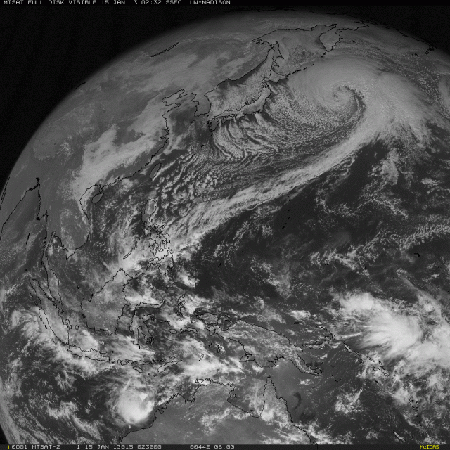
Well that would fit the time frame when this monster extratropical cyclone in the North Pacific would arrive on the west coast....this storm according to the GFS will bomb out and deepen to around 932 mb over the next 24 hours. This would make it one of the most rapidly developing storms of all time if it were to verify. Now models still aren't sure where this storm will end up but some have it arriving on the west coast in about 10 days. Something to follow over the next 7-10 days to fit your forecast Ntxw....
http://www.weatherbell.com/images/imgup ... sregg7.gif


weatherdude1108 wrote:orangeblood wrote:Ntxw wrote:Looking ahead again (you knew it was coming
Well that would fit the time frame when this monster extratropical cyclone in the North Pacific would arrive on the west coast....this storm according to the GFS will bomb out and deepen to around 932 mb over the next 24 hours. This would make it one of the most rapidly developing storms of all time if it were to verify. Now models still aren't sure where this storm will end up but some have it arriving on the west coast in about 10 days. Something to follow over the next 7-10 days to fit your forecast Ntxw....
http://www.weatherbell.com/images/imgup ... sregg7.gif

I noticed the chatter on this potential storm stopped. Just curious on any new updates with it, or if it's even there anymore(?). Is this the same storm that is now south of Alaska and way off the coast of the Pacific NW?
rkbjunior wrote:Larry Cosgrove gives us a tease at the end of his discussion.
http://www.examiner.com/article/weekend-weather-forecast-for-houston-texas-and-vicinity-friday-01-18-2013

Portastorm wrote:orangeblood wrote:Latest AO forecast = NOT GOOD!!!
orangeblood, you have been a steady and admirable colleague of the PWC ... don't lose the faith just because we have a 7-10 day period of winter "doldrums." There will be more action on the way. Keep the faith!
I believe our window of opportunities will re-open in about 10 days.
Users browsing this forum: kevin and 58 guests

