But there would be a lot of surprised people.
Texas Winter 2012-2013
Moderator: S2k Moderators
Forum rules
 The posts in this forum are NOT official forecast and should not be used as such. They are just the opinion of the poster and may or may not be backed by sound meteorological data. They are NOT endorsed by any professional institution or STORM2K.

The posts in this forum are NOT official forecast and should not be used as such. They are just the opinion of the poster and may or may not be backed by sound meteorological data. They are NOT endorsed by any professional institution or STORM2K.
-
somethingfunny

- ChatStaff

- Posts: 3926
- Age: 37
- Joined: Thu May 31, 2007 10:30 pm
- Location: McKinney, Texas
If we called for winters like 2011 and 2006 every year, nobody would ever be disappointed.
But there would be a lot of surprised people.
But there would be a lot of surprised people.
0 likes
I am not a meteorologist, and any posts made by me are not official forecasts or to be interpreted as being intelligent. These posts are just my opinions and are probably silly opinions.

NDG does make a good point about SSW and teleconnections so lets clarify this a little bit. SSW has really one major purpose and that is to predict the -AO, not send record cold to the US. The -AO is what delivers cold to the source regions (Siberia and Canada). To get record cold you must have that followed by a favorable teleconnection set up so lets stop blaming SSW for delivering or not in the future. It is an indicator and only that
0 likes
The above post and any post by Ntxw is NOT an official forecast and should not be used as such. It is just the opinion of the poster and may or may not be backed by sound meteorological data. It is NOT endorsed by any professional institution including Storm2k. For official information, please refer to NWS products.
Help support Storm2K!
-
Portastorm

- Storm2k Moderator

- Posts: 9954
- Age: 63
- Joined: Fri Jul 11, 2003 9:16 am
- Location: Round Rock, TX
- Contact:
Re:
Ntxw wrote:NDG does make a good point about SSW and teleconnections so lets clarify this a little bit. SSW has really one major purpose and that is to predict the -AO, not send record cold to the US. The -AO is what delivers cold to the source regions (Siberia and Canada). To get record cold you must have that followed by a favorable teleconnection set up so lets stop blaming SSW for delivering or not in the future. It is an indicator and only that
Ding! Ding! Ding! Someone get this man a cigar!!
SSW events have delivered the goods this year and last year ... just ask folks in Europe or Asia (China or Russia). There's so much that has to happen to have a legitimate Arctic outbreak into the Southern Plains or the Deep South that it's not funny. A SSW is just the start. As you guys have already said, teleconnections and the drivers behind those teleconnections are what dictates where the airmasses go.
0 likes
Any forecasts under my name are to be taken with a grain of salt. Get your best forecasts from the National Weather Service and National Hurricane Center.
-
SaskatchewanScreamer
Smile it could be worse......
https://www.youtube.com/watch?v=kvPyS35QTxM
I don't think there was anything offensive in there.
Still want our snow?
p.s. it is a whole lot uglier out there this year.

you also have mail Ntxw.
https://www.youtube.com/watch?v=kvPyS35QTxM
I don't think there was anything offensive in there.
Still want our snow?
p.s. it is a whole lot uglier out there this year.
you also have mail Ntxw.
0 likes

Re:
Ntxw wrote:Since extreme cold is no longer likely for next week, lets see if we can set up a block on Hudson Bay for a snowy pattern. DFW is also overdue for March snow!
Hopefully our beloved month of February will live up to its reputation!
I was off here for 1 week and I don't know how things transpired but as of right now where is the PV most likely to set up in NA? If there was another big discussion on the overall atmosphere in North America (and world) and long range, do you know what pages it was on? I would like to read it. 40 pages is a lot to go through so I rather not look
0 likes
-
somethingfunny
- ChatStaff
- Posts: 3926
- Age: 37
- Joined: Thu May 31, 2007 10:30 pm
- Location: McKinney, Texas
Re: Re:
Cyclenall wrote:Ntxw wrote:Since extreme cold is no longer likely for next week, lets see if we can set up a block on Hudson Bay for a snowy pattern. DFW is also overdue for March snow!
Hopefully our beloved month of February will live up to its reputation!
I was off here for 1 week and I don't know how things transpired but as of right now where is the PV most likely to set up in NA? If there was another big discussion on the overall atmosphere in North America (and world) and long range, do you know what pages it was on? I would like to read it. 40 pages is a lot to go through so I rather not look. The models are now in range for the time period where the SSW event would translate to ground truth cold.
Most of those 40 pages contain a rather magical event that happened last Tuesday.
0 likes
I am not a meteorologist, and any posts made by me are not official forecasts or to be interpreted as being intelligent. These posts are just my opinions and are probably silly opinions.
-
Portastorm
- Storm2k Moderator
- Posts: 9954
- Age: 63
- Joined: Fri Jul 11, 2003 9:16 am
- Location: Round Rock, TX
- Contact:
Re: Texas Winter 2012-2013
The 6z GFS operational run shows a potent winter storm for the northern half of Texas late (yes "la-la land") in its run. View, fantasize, enjoy.

Uploaded with ImageShack.us

Uploaded with ImageShack.us
0 likes
Any forecasts under my name are to be taken with a grain of salt. Get your best forecasts from the National Weather Service and National Hurricane Center.
Re: Re:
Cyclenall wrote:I was off here for 1 week and I don't know how things transpired but as of right now where is the PV most likely to set up in NA? If there was another big discussion on the overall atmosphere in North America (and world) and long range, do you know what pages it was on? I would like to read it. 40 pages is a lot to go through so I rather not look
As with most complete warming events (not certain for all cases but most strong ones) the vortex was split. The troposphere reflections left one in Hudson Bay and one in North-Central Russia. They remain there until the upper strat cools and re-consolidates <- this won't likely happen this winter since the warming lasted so long and continues so the twin vortexes will likely remain in place. Next week high pressure will help bump the Canadian one east/se through interior Ontario and Quebec before reforming around the bay.

0 likes
The above post and any post by Ntxw is NOT an official forecast and should not be used as such. It is just the opinion of the poster and may or may not be backed by sound meteorological data. It is NOT endorsed by any professional institution including Storm2k. For official information, please refer to NWS products.
Help support Storm2K!
Help support Storm2K!
There's some better news today on the AO, not crazy +s
http://www.cpc.ncep.noaa.gov/products/p ... ensm.shtml
http://www.cpc.ncep.noaa.gov/products/p ... ensm.shtml
0 likes
The above post and any post by Ntxw is NOT an official forecast and should not be used as such. It is just the opinion of the poster and may or may not be backed by sound meteorological data. It is NOT endorsed by any professional institution including Storm2k. For official information, please refer to NWS products.
Help support Storm2K!
Help support Storm2K!
-
orangeblood
- S2K Supporter

- Posts: 3895
- Joined: Tue Dec 15, 2009 6:14 pm
- Location: Fort Worth, TX
Re: Texas Winter 2012-2013
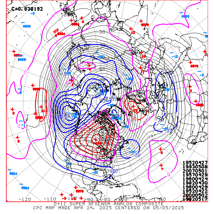
Some of the coldest periods of the last 50 years are showing up on the Day 11 Analogs (January 30th)....late Jan 1985 & 1963 top the charts! You can see the dates in the lower right hand corner
0 likes
-
orangeblood
- S2K Supporter
- Posts: 3895
- Joined: Tue Dec 15, 2009 6:14 pm
- Location: Fort Worth, TX
Re:
BigB0882 wrote:But will that cold come down to the deep south or stay off to the east?
The west coast ridge line on the day 10-11 analogs is MUCH more favorable for arctic air to pour straight down the spine of the rockies into the southern plains....lets just hope they're onto something
0 likes
Yes, we want the very -EPO (ridge to Alaska) over the very +PNA (into Canada) look
0 likes
The above post and any post by Ntxw is NOT an official forecast and should not be used as such. It is just the opinion of the poster and may or may not be backed by sound meteorological data. It is NOT endorsed by any professional institution including Storm2k. For official information, please refer to NWS products.
Help support Storm2K!
Help support Storm2K!
-
Texas Snowman

- Storm2k Moderator
- Posts: 6197
- Joined: Fri Jan 25, 2008 11:29 am
- Location: Denison, Texas
Re: Texas Winter 2012-2013
Portastorm wrote:The 6z GFS operational run shows a potent winter storm for the northern half of Texas late (yes "la-la land") in its run. View, fantasize, enjoy.
Uploaded with ImageShack.us
That's the Portastorm we all know and love! Whew, for several days, I was worried that the Heat Miser's effects were permanent!
0 likes
The above post and any post by Texas Snowman is NOT an official forecast and should not be used as such. It is just the opinion of the poster and may or may not be backed by sound meteorological data. It is NOT endorsed by any professional institution including storm2k.org. For official information, please refer to NWS products.
-
aggiecutter
- Category 5

- Posts: 1755
- Joined: Thu Oct 14, 2004 9:22 pm
- Location: Texarkana
Re: Texas Winter 2012-2013
OK, what is JB seeing in the EURO Ensembles to cause him to tweet that the 1st-15th will be the coldest we've seen since 07. The 12z Ensembles only go out to the 29th. The pattern at that time looks somewhat similar to the one we've been in for the past couple weeks. Any thoughts.
12z EURO Ensembles:
http://raleighwx.americanwx.com/models/ ... yNA240.gif
12z EURO Ensembles:
http://raleighwx.americanwx.com/models/ ... yNA240.gif
0 likes
-
orangeblood
- S2K Supporter
- Posts: 3895
- Joined: Tue Dec 15, 2009 6:14 pm
- Location: Fort Worth, TX
Re: Texas Winter 2012-2013
aggiecutter wrote:OK, what is JB seeing in the EURO Ensembles to cause him to tweet that the 1st-15th will be the coldest we've seen since 07. The 12z Ensembles only go out to the 29th. The pattern at that time looks somewhat similar to the one we've been in for the past couple weeks. Any thoughts.
12z EURO Ensembles:
http://raleighwx.americanwx.com/models/ ... yNA240.gif
JB is a professional hype artist and that is a very bold forecast even for his standards. It going to be very hard to beat Feb.1-15, 2011 much less 2007. But that ensemble pic you just posted aggiecutter is intriguing as it would drop the PV much farther south across the Canadian border towards the end of the month.
0 likes
-
TeamPlayersBlue

- Category 5
- Posts: 3524
- Joined: Tue Feb 02, 2010 1:44 am
- Location: Denver/Applewood, CO
Re: Texas Winter 2012-2013
aggiecutter wrote:OK, what is JB seeing in the EURO Ensembles to cause him to tweet that the 1st-15th will be the coldest we've seen since 07. The 12z Ensembles only go out to the 29th. The pattern at that time looks somewhat similar to the one we've been in for the past couple weeks. Any thoughts.
12z EURO Ensembles:
http://raleighwx.americanwx.com/models/ ... yNA240.gif
JB call for the second half of the the 06-07 winter is why i am a 'weather' fan of JB. If you remember correctly, 06 winter started out very warm for most of us, mostly in the East. Plants were blooming in late november early dec etc. Well I remember i came back from skiing to look at an accuweather video of JB and he was adament that the next half of the winter will be brutal and completely make up for lost time. Boy was he right. That was the first time i was actually tired of winter. We had numerous cold shot after cold shot while i was in school in east texas and it was brutal. No huge snow event but lots of small ice events and hardcore cold. If iirc, the polar vortex split that year.
I vividly remember one time at our house in the country, we had a dirt road and water would pool up when it rains alot. Well during one of these cold events, the pool of water was ice for 3 days. Another was when it was in the low 20's and windy, so what else would you do on the weekends.... START A BONFIRE, YEAH...... Lasted 10 minutes out there, the fire was blowing all heat in the same direction as the smoke and it was useless. We were at the bar in no time.
0 likes
Personal Forecast Disclaimer:
The posts in this forum are NOT official forecast and should not be used as such. They are just the opinion of the poster and may or may not be backed by sound meteorological data. They are NOT endorsed by any professional institution or storm2k.org. For official information, please refer to the NHC and NWS products.
The posts in this forum are NOT official forecast and should not be used as such. They are just the opinion of the poster and may or may not be backed by sound meteorological data. They are NOT endorsed by any professional institution or storm2k.org. For official information, please refer to the NHC and NWS products.
JB is good at giving resources for a wide look at patterns, his skill in the long range without model hugging is one of the best for this time range. Sometimes his need to get snow/cold to the I-95 corridor clouds his judgement for being too "hypist" as a pro met. He's often burned by moving the pattern too fast and a lot of times we mistake his comments as they generally are bias mostly for the east coast. Lately one or two inch snows there gets him excited which normally is no big deal for them.
GWO is rising and usually when it does there's a tendency for continued blocking, not to be confused with the MJO. High AAM is more Nino-like state (active storms and blocks), low AAM is La Nina-like.

GWO is rising and usually when it does there's a tendency for continued blocking, not to be confused with the MJO. High AAM is more Nino-like state (active storms and blocks), low AAM is La Nina-like.
0 likes
The above post and any post by Ntxw is NOT an official forecast and should not be used as such. It is just the opinion of the poster and may or may not be backed by sound meteorological data. It is NOT endorsed by any professional institution including Storm2k. For official information, please refer to NWS products.
Help support Storm2K!
Help support Storm2K!
-
Portastorm
- Storm2k Moderator
- Posts: 9954
- Age: 63
- Joined: Fri Jul 11, 2003 9:16 am
- Location: Round Rock, TX
- Contact:
Re: Texas Winter 2012-2013
Taking a look at the 12z ensembles for the GFS, Euro, and Canadian ... the GFS clearly has the deepest trough immediately to our (Texas) west and, yes, it does look progressive. Both the Euro and Canadian (GGEM) aren't nearly as deep with the trough. Those of us wanting a winter storm need that GFS to verify. But, of course, lots of time between now and then.
Meanwhile I have to concede that I've grown tired of the "historic cold" hype from various pro mets and amateurs. It gets thrown around way too much, some folks set their anticipation level to that, they end up disappointed and angry and you know the rest. What do we know? We know the pattern may change again next weekend with a potential back to more "wintry" solutions for Texas. My two pesos.
Meanwhile I have to concede that I've grown tired of the "historic cold" hype from various pro mets and amateurs. It gets thrown around way too much, some folks set their anticipation level to that, they end up disappointed and angry and you know the rest. What do we know? We know the pattern may change again next weekend with a potential back to more "wintry" solutions for Texas. My two pesos.
0 likes
Any forecasts under my name are to be taken with a grain of salt. Get your best forecasts from the National Weather Service and National Hurricane Center.
Who is online
Users browsing this forum: No registered users and 38 guests