2013 Steering Pattern / Early indicators
Moderator: S2k Moderators
Forum rules

The posts in this forum are NOT official forecasts and should not be used as such. They are just the opinion of the poster and may or may not be backed by sound meteorological data. They are NOT endorsed by any professional institution or STORM2K. For official information, please refer to products from the National Hurricane Center and National Weather Service.
-
Riptide

- Category 2

- Posts: 753
- Age: 34
- Joined: Fri Jul 23, 2010 3:33 pm
- Location: Cape May, New Jersey
- Contact:
Re: 2013 Steering Pattern / Early indicators
There are signs of the low instability pattern breaking down with the increasing Intertropical Convergence activity. Much improved over last year...
0 likes
-
Hurricaneman

- Category 5

- Posts: 7404
- Age: 45
- Joined: Tue Aug 31, 2004 3:24 pm
- Location: central florida
Re: 2013 Steering Pattern / Early indicators
Riptide wrote:There are signs of the low instability pattern breaking down with the increasing Intertropical Convergence activity. Much improved over last year...
http://www.ssd.noaa.gov/PS/TROP/TCFP/da ... xyains.gif
If this really is a pattern shift, this could get really ugly for any possible hurricane landfall so it really is a thing to keep an eye on
0 likes
-
Riptide
- Category 2
- Posts: 753
- Age: 34
- Joined: Fri Jul 23, 2010 3:33 pm
- Location: Cape May, New Jersey
- Contact:
Re: 2013 Steering Pattern / Early indicators
Hurricaneman wrote:Riptide wrote:There are signs of the low instability pattern breaking down with the increasing Intertropical Convergence activity. Much improved over last year...
http://www.ssd.noaa.gov/PS/TROP/TCFP/da ... xyains.gif
If this really is a pattern shift, this could get really ugly for any possible hurricane landfall so it really is a thing to keep an eye on
Yes, the atmospheric pressures are below average in relation to climate averages currently. I have been worried about this year since 2011 as we are coming out of a multi-year la nina followed by neutral/weak-el nino conditions, somewhat similar to 2005.
Current Mean Sea Level Pressure
Daily Average
0 likes
-
Riptide
- Category 2
- Posts: 753
- Age: 34
- Joined: Fri Jul 23, 2010 3:33 pm
- Location: Cape May, New Jersey
- Contact:
Re: 2013 Steering Pattern / Early indicators
Current and forecasted vertical wind shear profiles show a continuation of below average wind shear in the Tropical Atlantic.

0 likes
-
cycloneye

- Admin

- Posts: 149471
- Age: 69
- Joined: Thu Oct 10, 2002 10:54 am
- Location: San Juan, Puerto Rico
Re: 2013 Steering Pattern / Early indicators
Another thing to watch in the comming weeks will be how the NAO behaves because a negative NAO means warmer sst's in MDR. The GFS ensembles forecast that for late Febuary/early March timeframe.Let's see how things evolve with the NAO by May/June/July.

0 likes
Visit the Caribbean-Central America Weather Thread where you can find at first post web cams,radars
and observations from Caribbean basin members Click Here
and observations from Caribbean basin members Click Here
-
vbhoutex

- Storm2k Executive
- Posts: 29149
- Age: 74
- Joined: Wed Oct 09, 2002 11:31 pm
- Location: Cypress, TX
- Contact:
Re:
xcool22 wrote:what is analog year!!!!! ???
An analog year is a previous year where the weather patterns match or closely match those that are occurring or expected to occur during the year being discussed.
0 likes
Skywarn, C.E.R.T.
Please click below to donate to STORM2K to help with the expenses of keeping the site going:

Please click below to donate to STORM2K to help with the expenses of keeping the site going:
-
tolakram
- Admin
- Posts: 20185
- Age: 62
- Joined: Sun Aug 27, 2006 8:23 pm
- Location: Florence, KY (name is Mark)
Re: 2013 Steering Pattern / Early indicators
Not sure what some are using to see vertical instability, I use this page: http://www.ssd.noaa.gov/PS/TROP/TCFP/atlantic.html
Tropical Atlantic is still way below normal.

Tropical Atlantic is still way below normal.
0 likes
M a r k
- - - - -
Join us in chat: Storm2K Chatroom Invite. Android and IOS apps also available.
The posts in this forum are NOT official forecasts and should not be used as such. Posts are NOT endorsed by any professional institution or STORM2K.org. For official information and forecasts, please refer to NHC and NWS products.
-
Riptide
- Category 2
- Posts: 753
- Age: 34
- Joined: Fri Jul 23, 2010 3:33 pm
- Location: Cape May, New Jersey
- Contact:
Re: 2013 Steering Pattern / Early indicators
Vertical instability is still below average but there is a slight improvement trend with new activity over Eastern Africa that may translate downstream. The Mean Sea Level Pressures are not particularly high which is a good sign for instability. Looks lower than last year...
0 likes
-
wxman57

- Moderator-Pro Met

- Posts: 23174
- Age: 68
- Joined: Sat Jun 21, 2003 8:06 pm
- Location: Houston, TX (southwest)
Re: 2013 Steering Pattern / Early indicators
Last year at this time, the vertical instability in the tropical Atlantic was normal to a bit above normal. It's a lot less/lower this year. Instability has been lacking the past 2 seasons, though we've had 19 named storms each year. Many of those storms were weak/short-lived, and there was not one hurricane in the MDL in 2012. Most formed in the subtropics. Will the deep tropics be as unfavorable or more so than last year?
2012 Tropical Atlantic Instability:
ftp://rammftp.cira.colostate.edu/schuma ... tatins.gif
2012 Tropical Atlantic Instability:
ftp://rammftp.cira.colostate.edu/schuma ... tatins.gif
0 likes
-
Riptide
- Category 2
- Posts: 753
- Age: 34
- Joined: Fri Jul 23, 2010 3:33 pm
- Location: Cape May, New Jersey
- Contact:
Re: 2013 Steering Pattern / Early indicators
There could be an inverse correlation with instability. Higher instability values in late Winter and early Spring might imply low instability during summer and vice versa. Just speculating but I would not write off the season just because of limited instability.
0 likes
-
cycloneye
- Admin
- Posts: 149471
- Age: 69
- Joined: Thu Oct 10, 2002 10:54 am
- Location: San Juan, Puerto Rico
Re: 2013 Steering Pattern / Early indicators
While the low instability goes on in the Tropical Atlantic,in another region Vertical Instability is near normal in the Caribbean. Let's see how it continues to fluctuate in the comming weeks.

0 likes
Visit the Caribbean-Central America Weather Thread where you can find at first post web cams,radars
and observations from Caribbean basin members Click Here
and observations from Caribbean basin members Click Here
-
TropicalAnalystwx13

- Category 5
- Posts: 2109
- Age: 28
- Joined: Tue Jul 19, 2011 8:20 pm
- Location: Wilmington, NC
- Contact:
-
Hurricaneman
- Category 5
- Posts: 7404
- Age: 45
- Joined: Tue Aug 31, 2004 3:24 pm
- Location: central florida
Heres the instability numbers by region campared to normal
February 20
GOM: Average -11 Current -12 which is 1 below normal instability
Carribean: Average -1 Current -1 normal instability
East Coast: Average -12 current -11 which is 1 above normal instability
Tropical Atlantic: Average -1 Current -7 which is 6 below normal instability
Subtrop Atlantic: Average -9 current -12 which is 3 below normal instability
so if you add up all the instability numbers through all regions it equals 9 below normal instability which if this continues through hurricane season could stiffel development if it remains as is
I will be doing daily updates to this to see if there's any change from now until the peak of hurricane season
0 likes
-
cycloneye
- Admin
- Posts: 149471
- Age: 69
- Joined: Thu Oct 10, 2002 10:54 am
- Location: San Juan, Puerto Rico
Re:
Hurricaneman wrote:Heres the instability numbers by region campared to normal
February 20
GOM: Average -11 Current -12 which is 1 below normal instability
Carribean: Average -1 Current -1 normal instability
East Coast: Average -12 current -11 which is 1 above normal instability
Tropical Atlantic: Average -1 Current -7 which is 6 below normal instability
Subtrop Atlantic: Average -9 current -12 which is 3 below normal instability
so if you add up all the instability numbers through all regions it equals 9 below normal instability which if this continues through hurricane season could stiffel development if it remains as is
I will be doing daily updates to this to see if there's any change from now until the peak of hurricane season
Thanks for bringing those interesting stats. Keep them comming.
0 likes
Visit the Caribbean-Central America Weather Thread where you can find at first post web cams,radars
and observations from Caribbean basin members Click Here
and observations from Caribbean basin members Click Here
-
cycloneye
- Admin
- Posts: 149471
- Age: 69
- Joined: Thu Oct 10, 2002 10:54 am
- Location: San Juan, Puerto Rico
Re: 2013 Steering Pattern / Early indicators
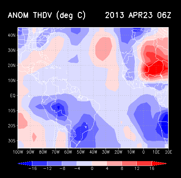
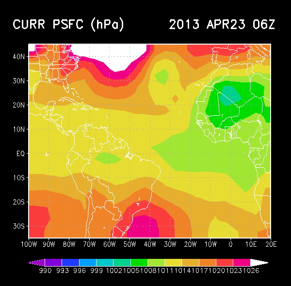
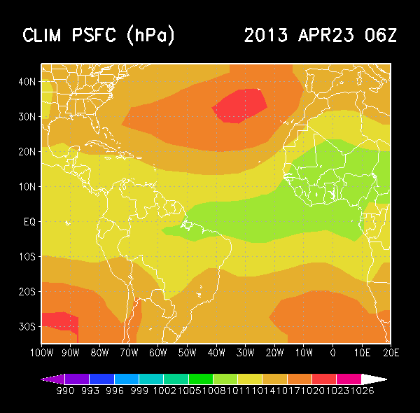
There is a difference in the sst anomalies between 2012 and 2013 as the Tropical Atlantic is warmer than last year. Also there is a difference in the Pacific with less warm waters in 2013 than in 2012.
20th of Febuary 2012.

21rst of Febuary 2013.

20th of Febuary 2012.
21rst of Febuary 2013.
0 likes
Visit the Caribbean-Central America Weather Thread where you can find at first post web cams,radars
and observations from Caribbean basin members Click Here
and observations from Caribbean basin members Click Here
-
cycloneye
- Admin
- Posts: 149471
- Age: 69
- Joined: Thu Oct 10, 2002 10:54 am
- Location: San Juan, Puerto Rico
Re: 2013 Steering Pattern / Early indicators
cycloneye wrote:Another thing to watch in the comming weeks will be how the NAO behaves because a negative NAO means warmer sst's in MDR. The GFS ensembles forecast that for late Febuary/early March timeframe.Let's see how things evolve with the NAO by May/June/July.
http://i46.tinypic.com/263va68.jpg
The operational GFS and ECMWF continue to forecast negative NAO for the next 2 weeks. The bigger question going forward is how this factor will be by May,June,July,August and September.


0 likes
Visit the Caribbean-Central America Weather Thread where you can find at first post web cams,radars
and observations from Caribbean basin members Click Here
and observations from Caribbean basin members Click Here


We had a little discussion earlier today in the Texas thread about the -PDO/+AMO periods. Wxman57 mentioned that the 40s, 50s, and 60s were very identical to the oceanic cycle as today's with those two couplets which featured numerous hits for the northeast (Hazel, Carol, Donna, Edna etc). The past two seasons the northeast coast of the US have been directly effected by substantial cyclones (Irene, Sandy), with the subtropics continuing to be favorable for systems I would think this season and the next several will be the same giving higher threat again to the big populations of the mid-Atlantic and New England coasts.
I suspect cycloneye's watch of the NAO has some influence from these cycles as well. Those years favored very much the -NAO (Greenland block). This traps storms from recurving into Atlantic Canada or out to sea since it is a block and storms cannot drive into blocks making bee lines into the US coast.
I suspect cycloneye's watch of the NAO has some influence from these cycles as well. Those years favored very much the -NAO (Greenland block). This traps storms from recurving into Atlantic Canada or out to sea since it is a block and storms cannot drive into blocks making bee lines into the US coast.
0 likes
The above post and any post by Ntxw is NOT an official forecast and should not be used as such. It is just the opinion of the poster and may or may not be backed by sound meteorological data. It is NOT endorsed by any professional institution including Storm2k. For official information, please refer to NWS products.
Help support Storm2K!
-
HURRICANELONNY
- Category 5
- Posts: 1392
- Joined: Wed May 07, 2003 6:48 am
- Location: HOLLYWOOD.FL
Who is online
Users browsing this forum: Europa non è lontana, NotSparta, Ntxw and 145 guests