ENSO Updates (2007 thru 2023)

This is the general tropical discussion area. Anyone can take their shot at predicting a storms path.

Moderator: S2k Moderators

Forum rules

The posts in this forum are NOT official forecasts and should not be used as such. They are just the opinion of the poster and may or may not be backed by sound meteorological data. They are NOT endorsed by any professional institution or STORM2K. For official information, please refer to products from the National Hurricane Center and National Weather Service.

Help Support Storm2K
Message
Author
User avatar
cycloneye
Admin
Admin
Posts: 145327
Age: 68
Joined: Thu Oct 10, 2002 10:54 am
Location: San Juan, Puerto Rico

Re: ENSO Updates

#2841 Postby cycloneye » Sat Feb 09, 2013 1:23 pm

USTropics wrote:This was posted about 2 days ago:
Original Link: http://www.reuters.com/article/2013/02/07/us-weather-elnio-cpc-idUSBRE91610720130207
NOAA Report: http://www.cpc.ncep.noaa.gov/products/analysis_monitoring/enso_advisory/ensodisc.html

(Reuters) - The National Oceanic and Atmospheric Administration (NOAA), a key U.S. weather forecaster, on Thursday held to its view that the El Niño climate phenomenon should pose few weather problems in the Northern Hemisphere through spring.

In its monthly report, the U.S. Climate Prediction Center (CPC), a part of NOAA's National Weather Service, said prediction models overall point to a neutral forecast through spring, though it has less confidence in its outlook for summer.

While maintaining a neutral outlook, the report added that temperature variations in both the ocean and atmosphere increased during January.

Many forecasts showed below-average warmth in the eastern Pacific, but by late January, others pointed to warmer sea waters expanding toward the central Pacific Ocean.

The much-feared El Niño weather phenomenon heats up the tropical ocean in East Asia, sending warm air into the United States and South America, and often causing flooding and heavy rains.

It can also trigger drought in Southeast Asia and Australia, which produce some of the world's major food staples, such as sugar cane and grains.

At this point, however, meteorologists think the weather patterns are too weak to look for either El Niño or the La Niña phenomenon, which arises from cooler sea temperatures.

"Despite these transient features contributing to cool conditions, the collective atmospheric and oceanic system reflects ENSO (El Niño)-neutral," CPC said.


I was so concentrated on the big nor'easter that I forgot that the monthly CPC update was released. :) Interesting that they dont want to go beyond the Spring because of the not so reliable long range forecasts on the period between April anf June when model skill is generally low.
0 likes   
Visit the Caribbean-Central America Weather Thread where you can find at first post web cams,radars
and observations from Caribbean basin members Click Here

User avatar
cycloneye
Admin
Admin
Posts: 145327
Age: 68
Joined: Thu Oct 10, 2002 10:54 am
Location: San Juan, Puerto Rico

Re: ENSO Updates

#2842 Postby cycloneye » Mon Feb 11, 2013 10:02 am

Climate Prediction Center 2/11/13 update

No change to nino 3.4 as it remains for a second week in a row at -0.5C.

http://www.cpc.ncep.noaa.gov/products/a ... ts-web.pdf

Image
0 likes   
Visit the Caribbean-Central America Weather Thread where you can find at first post web cams,radars
and observations from Caribbean basin members Click Here

User avatar
Ntxw
Storm2k Moderator
Storm2k Moderator
Posts: 22785
Joined: Wed Oct 21, 2009 6:34 pm
Location: DFW, Texas

#2843 Postby Ntxw » Fri Feb 15, 2013 9:51 pm

SOI rose from the very negatives. 30 day and 90 are still low but with the daily's being weakly positive should drive it back up in the near future, that crazy run of a week appears to have subsided.
0 likes   
The above post and any post by Ntxw is NOT an official forecast and should not be used as such. It is just the opinion of the poster and may or may not be backed by sound meteorological data. It is NOT endorsed by any professional institution including Storm2k. For official information, please refer to NWS products.

  Help support Storm2K!
Help Support Storm2K

User avatar
cycloneye
Admin
Admin
Posts: 145327
Age: 68
Joined: Thu Oct 10, 2002 10:54 am
Location: San Juan, Puerto Rico

Re: ENSO Updates

#2844 Postby cycloneye » Mon Feb 18, 2013 9:13 am

The text of this week's CPC update will be released on Tuesday because of the Presidents day holiday but the graphic has been updated and Nino 3.4 warmed a little bit.

Image
0 likes   
Visit the Caribbean-Central America Weather Thread where you can find at first post web cams,radars
and observations from Caribbean basin members Click Here

User avatar
cycloneye
Admin
Admin
Posts: 145327
Age: 68
Joined: Thu Oct 10, 2002 10:54 am
Location: San Juan, Puerto Rico

Re: ENSO Updates

#2845 Postby cycloneye » Tue Feb 19, 2013 9:25 am

Climate Prediction Center 2/18/13 update

Nino 3.4 warmed slightly to -0.3C and that is up from -0.5C that was on last week's update.

http://www.cpc.ncep.noaa.gov/products/a ... ts-web.pdf
0 likes   
Visit the Caribbean-Central America Weather Thread where you can find at first post web cams,radars
and observations from Caribbean basin members Click Here

User avatar
cycloneye
Admin
Admin
Posts: 145327
Age: 68
Joined: Thu Oct 10, 2002 10:54 am
Location: San Juan, Puerto Rico

Re: Mid Febuary update of all models stay at Neutral thru ASO

#2846 Postby cycloneye » Thu Feb 21, 2013 1:46 pm

Mid Febuary update of all ENSO models

No El Nino nor La Nina by the peak of the hurricane Season according to the latest update.And it looks like no El Nino until the end of 2013. Read the discussion below the graphics. Let's remember that very long range forecasts are not too reliable but I have to post this news for information to the members.


Image

Image

http://portal.iri.columbia.edu/portal/s ... 2&userID=2

21 February 2013

Recent and Current Conditions

After a brief period of borderline El Niño SST conditions between July and September 2012, the SST anomaly in the Nino3.4 region returned to neutral levels during October and has remained neutral through mid-February 2013. For January 2013 the Nino3.4 SST anomaly was -0.41 C, indicative of cool-neutral ENSO conditions, and for November-January the anomaly was -0.05 C. Since late 2011, the IRI's definition of El Niño conditions has become the same as that of NOAA/Climate Prediction Center, in which the SST anomaly in the NINO3.4 region (5S-5N; 170W-120W) exceeds 0.5 C. Similarly, for La Niña, the anomaly must be -0.5 C or less. The climatological probabilities for La Niña, neutral, and El Niño conditions vary seasonally, and are shown in a table at the bottom of this page for each 3-month season. The most recent weekly SST anomaly in the NINO3.4 region was -0.3 C, indicating cool-neutral ENSO conditions in the tropical Pacific; this is similar to the -0.41 C level observed in January.

Expected Conditions

What is the outlook for the ENSO status going forward? The most recent official diagnosis and outlook was issued earlier this month in the NOAA/Climate Prediction Center ENSO Diagnostic Discussion, produced jointly by CPC and IRI; it called for a high likelihood of neutral ENSO conditions enduring through the first quarter of 2013, with probabilities of El Niño or La Niña each less than 30% through northern summer 2013. The latest set of model ENSO predictions, from mid-February, is now available in the IRI/CPC ENSO prediction plume, discussed below. Currently, SSTs are in the cool half of the ENSO-neutral range (anomaly of 0 to -0.5 C), and SST is above average in the western part of the basin. Subsurface temperatures across the equatorial Pacific average close to the climatological average, but are above average in the western half of the basin and below average in the east-central and eastern Pacific. In the atmosphere, the basin-wide sea level pressure pattern (e.g. the SOI), has been near to slightly below average (toward El Niño) but the low-level zonal winds have slightly favored enhanced trade winds. Anomalous convection (as measured by OLR) has generally been below average in the central tropical Pacific, and above average in the far western part of the basin. Together, although these last features exhibit gradients similar to those found during La Niña, all of the the features collectively reflect ENSO-neutral conditions, leaning to the cool side.

As of mid-February, 28% of the set of dynamical and statistical models models predicts weak La Niña SST conditions for the Feb-Apr 2013 season, none predicts El Niño conditions, and 72% indicates neutral ENSO. At lead times of 3 or more months into the future, statistical and dynamical models that incorporate information about the ocean's observed subsurface thermal structure generally exhibit higher predictive skill than those that do not. For the May-Jul season, among models that do use subsurface temperature information, 100% predict ENSO-neutral SSTs, 0% predicts El Niño conditions and 0% predicts La Niña contitions. For all model types, the probability for neutral ENSO conditions is 80% or greater from Apr-Jun to the end of the forecast period in northern autumn 2013. (Note 1). Caution is advised in interpreting the distribution of model predictions as the actual probabilities. At longer leads, the skill of the models degrades, and skill uncertainty must be convolved with the uncertainties from initial conditions and differing model physics, leading to more climatological probabilities in the long-lead ENSO Outlook than might be suggested by the suite of models. Furthermore, the expected skill of one model versus another has not been established using uniform validation procedures, which may cause a difference in the true probability distribution from that taken verbatim from the raw model predictions.


An alternative way to assess the probabilities of the three possible ENSO conditions is more quantitatively precise and less vulnerable to sampling errors than the categorical tallying method used above. This alternative method uses the mean of the predictions of all models on the plume, equally weighted, and constructs a standard error function centered on that mean. The standard error is Gaussian in shape, and has its width determined by an estimate of overall expected model skill for the season of the year and the lead time. Higher skill results in a relatively narrower error distribution, while low skill results in an error distribution with width approaching that of the historical observed distribution. This method shows probabilities for La Niña at 26% for Feb-Apr 2013, 28% for Mar-May, and 27% for Apr-Jun 2013, remaining in the middle to upper 20s through northern autumn. Model probabilities for ENSO-neutral conditions are 74% for Feb-Apr 2013, 71% for Mar-May, and 69% for Apr-Jun 2013, decreasing into the 50s thereafter through autumn 2013. Probabilities for El Niño are near 0% for Feb-Apr 2013, 1% for Mar-May, rising to the 15-20% range from Jun-Aug through northern autumn. In words, the models collectively favor neutral ENSO conditions straight through to the third quarter of 2013, but during the first season or two La Niña is favored over El Niño. A plot of the probabilities generated from this most recent IRI/CPC ENSO prediction plume using the multi-model mean and the Gaussian standard error method summarizes the model consensus out to about 10 months into the future. The same cautions mentioned above for the distributional count of model predictions apply to this Gaussian standard error method of inferring probabilities, due to differing model biases and skills. In particular, this approach considers only the mean of the predictions, and not the total range across the models, nor the ensemble range within individual models.

The probabilities derived from the 24 or more models on the IRI/CPC plume describe, on average, maintenance of neutral ENSO conditions during the coming months, continuing through into the latter half of 2013. Uncertainty increases greatly from around the Apr-Jun 2013 season onward, when the probablilities for neutral ENSO settle into the 50s and probabilities for non-neutral ENSO increase to approximately one-in-four for La Niña and one-in-five for El Niño. Following this latest model-based ENSO plume prediction, factors such as known specific model biases and recent changes that the models may have missed will be taken into account in the next official outlook to be generated and issued in early January by CPC and IRI, which will include some human judgement in combination with the model guidance.
0 likes   
Visit the Caribbean-Central America Weather Thread where you can find at first post web cams,radars
and observations from Caribbean basin members Click Here

User avatar
Ntxw
Storm2k Moderator
Storm2k Moderator
Posts: 22785
Joined: Wed Oct 21, 2009 6:34 pm
Location: DFW, Texas

#2847 Postby Ntxw » Thu Feb 21, 2013 6:00 pm

I like this call by the CPC. There is no signal that points to growth for La Nina or El Nino still and probably won't see it until well into the northern hemisphere spring as weather patterns change if they do. SOI is backing off the negatives but not too positive, GWO is looping back and forth between + and - AAM, and PDO index is cold but barely so.
0 likes   
The above post and any post by Ntxw is NOT an official forecast and should not be used as such. It is just the opinion of the poster and may or may not be backed by sound meteorological data. It is NOT endorsed by any professional institution including Storm2k. For official information, please refer to NWS products.


  Help support Storm2K!

Help Support Storm2K


User avatar
cycloneye
Admin
Admin
Posts: 145327
Age: 68
Joined: Thu Oct 10, 2002 10:54 am
Location: San Juan, Puerto Rico

Re:

#2848 Postby cycloneye » Fri Feb 22, 2013 2:40 pm

Ntxw wrote:I like this call by the CPC. There is no signal that points to growth for La Nina or El Nino still and probably won't see it until well into the northern hemisphere spring as weather patterns change if they do. SOI is backing off the negatives but not too positive, GWO is looping back and forth between + and - AAM, and PDO index is cold but barely so.


Do you think that the barrier of Spring when the models are not a bit reliable may change the long range forecasts or no changes by them will occur after that period?
0 likes   
Visit the Caribbean-Central America Weather Thread where you can find at first post web cams,radars
and observations from Caribbean basin members Click Here

User avatar
Ntxw
Storm2k Moderator
Storm2k Moderator
Posts: 22785
Joined: Wed Oct 21, 2009 6:34 pm
Location: DFW, Texas

Re: Re:

#2849 Postby Ntxw » Fri Feb 22, 2013 6:26 pm

cycloneye wrote:Do you think that the barrier of Spring when the models are not a bit reliable may change the long range forecasts or no changes by them will occur after that period?


To be honest, I don't really know which way they will move. Nothing points one way or the other but spring is not the best time to predict ENSO as changes are occurring with SST's via the seasons. I can only guess it will stay the same and we can definitively say that between now and the next 3-5 months will be neutral.
0 likes   
The above post and any post by Ntxw is NOT an official forecast and should not be used as such. It is just the opinion of the poster and may or may not be backed by sound meteorological data. It is NOT endorsed by any professional institution including Storm2k. For official information, please refer to NWS products.


  Help support Storm2K!

Help Support Storm2K


User avatar
Ptarmigan
Category 5
Category 5
Posts: 5313
Joined: Wed Aug 16, 2006 9:06 pm

Re: Mid Feb update of ENSO models at Neutral thru next months

#2850 Postby Ptarmigan » Sun Feb 24, 2013 3:59 pm

Neutral ENSO can have an active season.
0 likes   

User avatar
Riptide
Category 2
Category 2
Posts: 753
Age: 34
Joined: Fri Jul 23, 2010 3:33 pm
Location: Cape May, New Jersey
Contact:

Re: Mid Feb update of ENSO models at Neutral thru next months

#2851 Postby Riptide » Sun Feb 24, 2013 4:03 pm

Ptarmigan wrote:Neutral ENSO can have an active season.

This does not necessarily mean that there will be an active season but 2005 was neutral/weak el nino.
0 likes   

User avatar
Ptarmigan
Category 5
Category 5
Posts: 5313
Joined: Wed Aug 16, 2006 9:06 pm

Re: Mid Feb update of ENSO models at Neutral thru next months

#2852 Postby Ptarmigan » Mon Feb 25, 2013 12:11 am

Riptide wrote:This does not necessarily mean that there will be an active season but 2005 was neutral/weak el nino.


2005 was an anomaly no matter how one spins it. It was also an Modoki El Nino in 2004-2005. I have noticed many active seasons following a Modoki El Nino like 1995, 2005, and 2010.
0 likes   

User avatar
cycloneye
Admin
Admin
Posts: 145327
Age: 68
Joined: Thu Oct 10, 2002 10:54 am
Location: San Juan, Puerto Rico

Re: ENSO:CPC 2/25/13 update=Nino 3.4 down to -0.5C

#2853 Postby cycloneye » Mon Feb 25, 2013 10:00 am

Climate Prediction Center 2/25/13 Update

Nino 3.4 cooled down to -0.5C and that is down from -0.3C that was on last week's update.

http://www.cpc.ncep.noaa.gov/products/a ... ts-web.pdf

Image
0 likes   
Visit the Caribbean-Central America Weather Thread where you can find at first post web cams,radars
and observations from Caribbean basin members Click Here

User avatar
Riptide
Category 2
Category 2
Posts: 753
Age: 34
Joined: Fri Jul 23, 2010 3:33 pm
Location: Cape May, New Jersey
Contact:

Re: ENSO:CPC 2/25/13 update=Nino 3.4 down to -0.5C

#2854 Postby Riptide » Mon Feb 25, 2013 3:23 pm

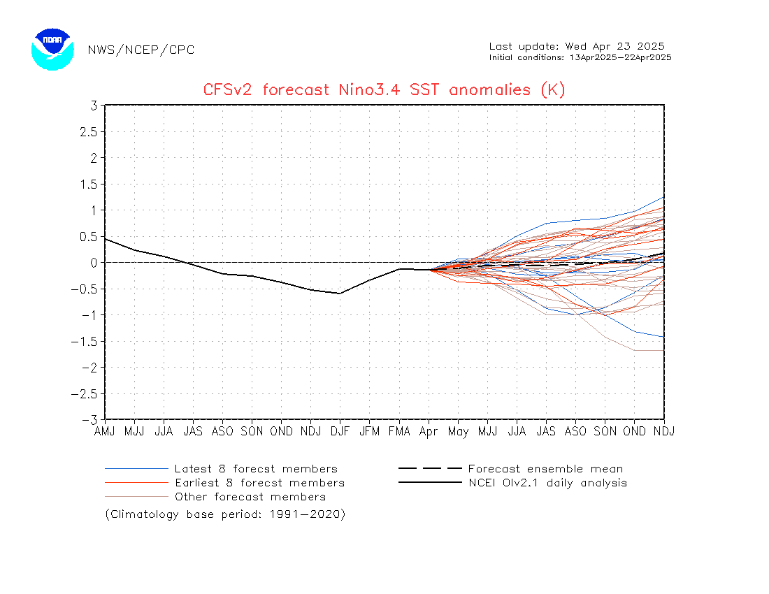
ENSO forecast from the CFS, not a good signal for anything. One can assume neutral for the next 6 months. Will be looking at other factors moreso this season such as the NAO and Madden-Julian Oscillation.

Image
0 likes   

User avatar
TropicalAnalystwx13
Category 5
Category 5
Posts: 2109
Age: 27
Joined: Tue Jul 19, 2011 8:20 pm
Location: Wilmington, NC
Contact:

Re: Mid Feb update of ENSO models at Neutral thru next months

#2855 Postby TropicalAnalystwx13 » Tue Feb 26, 2013 4:20 pm

Ptarmigan wrote:Neutral ENSO can have an active season.

For sure. In fact, most Neutral years have the most activity. Take 2005, 2011, and 2012 for example.

Image
0 likes   

User avatar
Ntxw
Storm2k Moderator
Storm2k Moderator
Posts: 22785
Joined: Wed Oct 21, 2009 6:34 pm
Location: DFW, Texas

Re: ENSO:CPC 2/25/13 update=Nino 3.4 down to -0.5C

#2856 Postby Ntxw » Thu Feb 28, 2013 3:49 pm

The latest MJO wave that began in the Indian Ocean mid February has made it through the Maritime continent and has entered the Western Pacific basin. As I mentioned in early Feb if the wave enters the Pacific it means the mechanism for cooling is not going to present itself for the month of March. This further solidifies the idea that no Nina will come/grow in the next 2-3 months. The back and forth between signals continue for neutral.
0 likes   
The above post and any post by Ntxw is NOT an official forecast and should not be used as such. It is just the opinion of the poster and may or may not be backed by sound meteorological data. It is NOT endorsed by any professional institution including Storm2k. For official information, please refer to NWS products.


  Help support Storm2K!

Help Support Storm2K


User avatar
cycloneye
Admin
Admin
Posts: 145327
Age: 68
Joined: Thu Oct 10, 2002 10:54 am
Location: San Juan, Puerto Rico

Re: ENSO:CPC 2/25/13 update=Nino 3.4 down to -0.5C

#2857 Postby cycloneye » Thu Feb 28, 2013 7:28 pm

Ntxw wrote:The latest MJO wave that began in the Indian Ocean mid February has made it through the Maritime continent and has entered the Western Pacific basin. As I mentioned in early Feb if the wave enters the Pacific it means the mechanism for cooling is not going to present itself for the month of March. This further solidifies the idea that no Nina will come/grow in the next 2-3 months. The back and forth between signals continue for neutral.


In other words Neutral jumping around from cold to warm or staying in the dead middle will be the norm going into the Summer as no big catalistic factor will change that scenario right?
0 likes   
Visit the Caribbean-Central America Weather Thread where you can find at first post web cams,radars
and observations from Caribbean basin members Click Here

User avatar
Ntxw
Storm2k Moderator
Storm2k Moderator
Posts: 22785
Joined: Wed Oct 21, 2009 6:34 pm
Location: DFW, Texas

Re: ENSO:CPC 2/25/13 update=Nino 3.4 down to -0.5C

#2858 Postby Ntxw » Fri Mar 01, 2013 3:55 pm

cycloneye wrote:
Ntxw wrote:The latest MJO wave that began in the Indian Ocean mid February has made it through the Maritime continent and has entered the Western Pacific basin. As I mentioned in early Feb if the wave enters the Pacific it means the mechanism for cooling is not going to present itself for the month of March. This further solidifies the idea that no Nina will come/grow in the next 2-3 months. The back and forth between signals continue for neutral.


In other words Neutral jumping around from cold to warm or staying in the dead middle will be the norm going into the Summer as no big catalistic factor will change that scenario right?


Definitely, I suspect that is why the cfsv2 forecasts a little warming this month overall because of the MJO. Had it stayed in Indonesia a runaway cooling feedback would have probably occured.

Looking at TAO Monday will continue the rollercoaster going up a bit
0 likes   
The above post and any post by Ntxw is NOT an official forecast and should not be used as such. It is just the opinion of the poster and may or may not be backed by sound meteorological data. It is NOT endorsed by any professional institution including Storm2k. For official information, please refer to NWS products.


  Help support Storm2K!

Help Support Storm2K


User avatar
cycloneye
Admin
Admin
Posts: 145327
Age: 68
Joined: Thu Oct 10, 2002 10:54 am
Location: San Juan, Puerto Rico

Re: ENSO Updates

#2859 Postby cycloneye » Sat Mar 02, 2013 6:02 pm

It's almost odd seeing the SOI and ESPI negative at the same time,but the running SOI shows it's trending back up and the daily SOI was slightly positive 0.5. It happens many times when ENSO is trending one way is the ESPI that really shows it first. Or if one really makes a move it forces the other.

Image

Image

http://www.longpaddock.qld.gov.au/seaso ... soivalues/

http://trmm.gsfc.nasa.gov//trmm_rain/Ev ... y_day.html
0 likes   
Visit the Caribbean-Central America Weather Thread where you can find at first post web cams,radars
and observations from Caribbean basin members Click Here

User avatar
Ntxw
Storm2k Moderator
Storm2k Moderator
Posts: 22785
Joined: Wed Oct 21, 2009 6:34 pm
Location: DFW, Texas

#2860 Postby Ntxw » Mon Mar 04, 2013 6:07 pm

This week's update for 3.4 is -0.3C
0 likes   
The above post and any post by Ntxw is NOT an official forecast and should not be used as such. It is just the opinion of the poster and may or may not be backed by sound meteorological data. It is NOT endorsed by any professional institution including Storm2k. For official information, please refer to NWS products.


  Help support Storm2K!

Help Support Storm2K


Return to “Talkin' Tropics”

Who is online

Users browsing this forum: AnnularCane and 38 guests