
Talking about the GFS messing up again just a couple of days ago it was forecasting near 80 degs for highs and lows near 60 for the Orlando area for Wed-Friday time frame, to turn around to now forecast highs to reach barely 70 on Thursday and for morning lows to be in the 40s, 30s for northern FL.
Chilly March continues.
Florida Weather
Moderator: S2k Moderators
Forum rules

The posts in this forum are NOT official forecast and should not be used as such. They are just the opinion of the poster and may or may not be backed by sound meteorological data. They are NOT endorsed by any professional institution or STORM2K.


Re: Florida Weather
The March sun is really starting to get a bite to it. If the sun is out it won't be bad.
0 likes
-
northjaxpro

- S2K Supporter

- Posts: 8900
- Joined: Mon Sep 27, 2010 11:21 am
- Location: Jacksonville, FL
Some overnight rain moving into the region as the cold front moves through into the morning hours tomorrow, then will clear out here by afternoon.
Yeah, another cool down as the upper trough briefly amplifies across the Eastern U.S. seaboard Wednesday through Friday. Minimum temps are forecast to be in the upper 30s inland areas Northeast FL during this period. We will see moderating temps heading into this upcoming weekend with temps returning to near 80 degrees in the Jax area by Sunday.
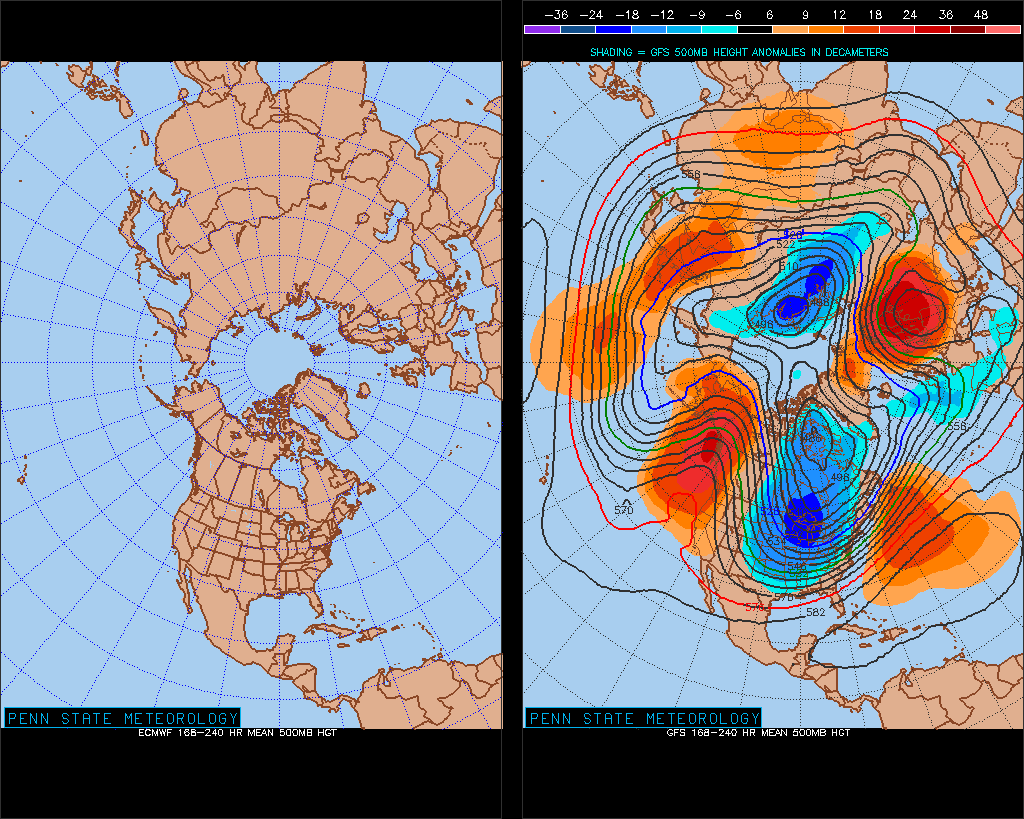
I did check the extended 7-10 day Euro and GFS model runs. The Euro, in particular, is hinting at another potential potent storm system to affect the East Coast next week. Lots can change of course with the details this far out, but something to watch for next week. At the very least, it looks as if the upper troughing pattern over the Eastern U.S. may continue next week. This will probably keep temps a bit below normal for this time of year across much of the peninsula.
Yeah, another cool down as the upper trough briefly amplifies across the Eastern U.S. seaboard Wednesday through Friday. Minimum temps are forecast to be in the upper 30s inland areas Northeast FL during this period. We will see moderating temps heading into this upcoming weekend with temps returning to near 80 degrees in the Jax area by Sunday.
I did check the extended 7-10 day Euro and GFS model runs. The Euro, in particular, is hinting at another potential potent storm system to affect the East Coast next week. Lots can change of course with the details this far out, but something to watch for next week. At the very least, it looks as if the upper troughing pattern over the Eastern U.S. may continue next week. This will probably keep temps a bit below normal for this time of year across much of the peninsula.
0 likes
NEVER, EVER SAY NEVER in the tropics and weather in general, and most importantly, with life itself!!
________________________________________________________________________________________
Fay 2008 Beryl 2012 Debby 2012 Colin 2016 Hermine 2016 Julia 2016 Matthew 2016 Irma 2017 Dorian 2019
________________________________________________________________________________________
Fay 2008 Beryl 2012 Debby 2012 Colin 2016 Hermine 2016 Julia 2016 Matthew 2016 Irma 2017 Dorian 2019
Re: Florida Weather
The persistent NAO and AO pattern will keep the northern and eastern US below average, luckly for us the models want to keep the PNA near neutral to negative, that would mean that we could see a break in the cooler next week with many areas back to a more persistent 80s pattern.
0 likes
-
northjaxpro
- S2K Supporter
- Posts: 8900
- Joined: Mon Sep 27, 2010 11:21 am
- Location: Jacksonville, FL
The cold front is currently moving through the area and I have only measured less than a tenth of an inch of rain at my locale.
Latest NWS projections are calling for min temps to drop into the mid 30s interior colder spots in the northern peninsula by Thursday morning and also on Friday morning with the potential of frost throughout the region, with the ridge axis getting closer by that time.
0 likes
NEVER, EVER SAY NEVER in the tropics and weather in general, and most importantly, with life itself!!
________________________________________________________________________________________
Fay 2008 Beryl 2012 Debby 2012 Colin 2016 Hermine 2016 Julia 2016 Matthew 2016 Irma 2017 Dorian 2019
________________________________________________________________________________________
Fay 2008 Beryl 2012 Debby 2012 Colin 2016 Hermine 2016 Julia 2016 Matthew 2016 Irma 2017 Dorian 2019
-
northjaxpro
- S2K Supporter
- Posts: 8900
- Joined: Mon Sep 27, 2010 11:21 am
- Location: Jacksonville, FL
Sunny and breezy conditions with currently 48.7 degrees. Expecting max temps today in the upper 60s.
There is a possibility of frost in the interior wind protected areas of the region as temps are expected to drop into the mid to upper 30s in the normal colder spots.
Tomorrow will be the coldest day as the upper level 500mb trough amplifies briefly across the Eastern U.S. Highs Thursday only near 60 with decent cold air advection. One more chilly and potential frost on Friday morning, then the moderation trend will begin as the upper trough lifts out. Should see high temps approaching 80 here during the weekend.
The models still differ on the potential storm affecting the Central Plains and east toward the Northeast U.S. By middle of next week. The Euro has been the more aggressive model with the system, but the GFS not as robust with the feature as of now. Still quite a bit of time to watch this, but I am hoping the 500mb upper pattern does not amplify significantly across the Eastern U.S next week.. This would be a great indicator that the persistant NAO pattern we have had in place for much of March may be finally loosening its grip and Spring can finally kick into gear.
0 likes
NEVER, EVER SAY NEVER in the tropics and weather in general, and most importantly, with life itself!!
________________________________________________________________________________________
Fay 2008 Beryl 2012 Debby 2012 Colin 2016 Hermine 2016 Julia 2016 Matthew 2016 Irma 2017 Dorian 2019
________________________________________________________________________________________
Fay 2008 Beryl 2012 Debby 2012 Colin 2016 Hermine 2016 Julia 2016 Matthew 2016 Irma 2017 Dorian 2019
Re: Florida Weather
Still looks like that the nice warm up for next week will stay in place for a while.
0 likes
-
northjaxpro
- S2K Supporter
- Posts: 8900
- Joined: Mon Sep 27, 2010 11:21 am
- Location: Jacksonville, FL
Yeah, NDG let's hope so. I am ready for spring weather now and I am having to keep putting off planting because of the frost we keep getting. Hopefully, this cool snap currently in place will absolutely be the last one this season!
0 likes
NEVER, EVER SAY NEVER in the tropics and weather in general, and most importantly, with life itself!!
________________________________________________________________________________________
Fay 2008 Beryl 2012 Debby 2012 Colin 2016 Hermine 2016 Julia 2016 Matthew 2016 Irma 2017 Dorian 2019
________________________________________________________________________________________
Fay 2008 Beryl 2012 Debby 2012 Colin 2016 Hermine 2016 Julia 2016 Matthew 2016 Irma 2017 Dorian 2019
Re: Florida Weather
As of 8 AM barely any 30s across northern FL, there is a good chance that MOS forecasted lows across the northern and central FL will bust by a good 5 degrees or so.
Lets hope that they also bust for you tomorrow morning, northjaxpro
Lets hope that they also bust for you tomorrow morning, northjaxpro
0 likes
Re: Florida Weather
Incredible difference between shade temperature and sun temperature outside.
Dew point in 20's.
Dew point in 20's.
0 likes
-
northjaxpro
- S2K Supporter
- Posts: 8900
- Joined: Mon Sep 27, 2010 11:21 am
- Location: Jacksonville, FL
Frost advisory is in place for all of inland Northeast Florida as very good radiational cooling conditions will be in place and there will be a few spots which may even reach the freezing mark briefly tomorrow morning.
Checking the latest model runs, they look very encouraging as the next upper trough traversing the northern tier of the CONUS next week appears likely not to amplify significantly across the Eastern U.S., alluding to the PNA being negative as NDG indicated earlier. Thus, we may finally be seeing Spring kick into gear beginning this weekend. I may finally get started planting a few vegetables (mainly tomatoes) in the coming days.
Checking the latest model runs, they look very encouraging as the next upper trough traversing the northern tier of the CONUS next week appears likely not to amplify significantly across the Eastern U.S., alluding to the PNA being negative as NDG indicated earlier. Thus, we may finally be seeing Spring kick into gear beginning this weekend. I may finally get started planting a few vegetables (mainly tomatoes) in the coming days.
0 likes
NEVER, EVER SAY NEVER in the tropics and weather in general, and most importantly, with life itself!!
________________________________________________________________________________________
Fay 2008 Beryl 2012 Debby 2012 Colin 2016 Hermine 2016 Julia 2016 Matthew 2016 Irma 2017 Dorian 2019
________________________________________________________________________________________
Fay 2008 Beryl 2012 Debby 2012 Colin 2016 Hermine 2016 Julia 2016 Matthew 2016 Irma 2017 Dorian 2019
overall, it's been a rather chilly first half of March. thank goodness this pattern didn't establish itself in january or we would have had some frozen oranges. i think it's all up from here...i'm ready to stash my jackets until at least next november and that looks increasingly likely after tonight's snappy temps.
0 likes
-
northjaxpro
- S2K Supporter
- Posts: 8900
- Joined: Mon Sep 27, 2010 11:21 am
- Location: Jacksonville, FL
35.4F at this hour with scattered frost. But, it is all good going forward as the warm-up will begin in earnest across the region. Beautiful weather coming for the next few days to come with no rain expected until about Wednesday of next week.
I will be happy to pronounce that hopefully we can say goodbye to Old Man Winter. This will be the last morning of 30s here until about late October or November. (knocking on wood)
I will be happy to pronounce that hopefully we can say goodbye to Old Man Winter. This will be the last morning of 30s here until about late October or November. (knocking on wood)
0 likes
NEVER, EVER SAY NEVER in the tropics and weather in general, and most importantly, with life itself!!
________________________________________________________________________________________
Fay 2008 Beryl 2012 Debby 2012 Colin 2016 Hermine 2016 Julia 2016 Matthew 2016 Irma 2017 Dorian 2019
________________________________________________________________________________________
Fay 2008 Beryl 2012 Debby 2012 Colin 2016 Hermine 2016 Julia 2016 Matthew 2016 Irma 2017 Dorian 2019
-
gatorcane

- S2K Supporter
- Posts: 23708
- Age: 48
- Joined: Sun Mar 13, 2005 3:54 pm
- Location: Boca Raton, FL
Re: Florida Weather
Looks like this pleasant, cool weather is going to come to an end soon...
I have had my windows open for over 2 weeks an no AC running. Back to reality I guess
NWS Miami long-term discussion snippet:
THE FRONT WILL THEN MOVE BACK NORTH LATE NEXT WEEK...AS LOW
PRESSURE DEVELOPS IN THE SOUTHERN GULF COAST STATES AND MOVES
NORTHEAST INTO THE SOUTHEASTERN UNITED STATES. THIS WILL CONTINUE
THE SOUTHERLY WIND FLOW OVER SOUTH FLORIDA...AND ALLOW FOR
TEMPERATURES TO WARM UP INTO THE MID/UPPER 80S TO EVEN AROUND 90
DEGREES INTERIOR WHICH WILL BE ABOUT 5 TO 10 DEGREES WARMER THAN
AVERAGE FOR THIS TIME OF YEAR
http://forecast.weather.gov/product.php?site=NWS&issuedby=MFL&product=AFD&format=CI&version=1&glossary=1
0 likes
Re: Florida Weather
I had coworkers come down during the last couple of days for a zone meeting here in Orlando, I was being very apologetic for the "colder" than normal temps for the last couple of days, they were like "what are you talking about, this feels great, much better than the 20s & 30s with snowy wx back in Buffalo" lol
I guess that the nice thing for this time of the year when we get these cold snaps temps in the 60s for highs feel warmer in the sun due to its higher angle.
MOS guidance through the next 7 days looks awesome, with highs near 80 and above!
KMCO GFSX MOS GUIDANCE 3/15/2013 1200 UTC
FHR 24 36| 48 60| 72 84| 96 108|120 132|144 156|168 180|192
SAT 16| SUN 17| MON 18| TUE 19| WED 20| THU 21| FRI 22|SAT CLIMO
N/X 47 79| 51 82| 60 84| 63 85| 59 80| 58 80| 61 87| 65 56 79
0 likes
Unreal 39.7F on Fri AM and 43.8F this morning! High Friday was only 66F as a stiff seabreeze kept us cool, only to die after sunset allowing temps to drop. This is due to the cold GOM at 61F. I live about a mile off the GOM. A warming this week but hints of even more cold weather down the pike for next weekend! I am so tired of this. We need Florida Wx to come back and stay - and some decent rainfall. Less than 3" recorded since Jan 1st! 
0 likes
Re: Florida Weather
Hope everyone enjoy's the warmer wx this weekened into most of next week, both the GFS and Euro, especially the euro, show yet another big cool down possibly for next weekend for the eastern US into the FL Peninsula as the PNA goes back to positive next weekend and the AO once again crashes over the next few days.

0 likes
Return to “USA & Caribbean Weather”
Who is online
Users browsing this forum: Iceresistance, Ntxw, Stratton23 and 123 guests