
I think this season will be much like the last few.
But 19 storms for a 4th straight year? Who knows.
2013 Steering Pattern / Early indicators
Moderator: S2k Moderators
Forum rules

The posts in this forum are NOT official forecasts and should not be used as such. They are just the opinion of the poster and may or may not be backed by sound meteorological data. They are NOT endorsed by any professional institution or STORM2K. For official information, please refer to products from the National Hurricane Center and National Weather Service.
-
TheStormExpert
-
cycloneye

- Admin

- Posts: 149471
- Age: 69
- Joined: Thu Oct 10, 2002 10:54 am
- Location: San Juan, Puerto Rico
Re: 2013 Steering Pattern / Early indicators
If the CFSv2 model is right,the Sahel region will be with plenty of moisture that helps to fuel the waves as they emerge West Africa. This forecast is for August.

0 likes
Visit the Caribbean-Central America Weather Thread where you can find at first post web cams,radars
and observations from Caribbean basin members Click Here
and observations from Caribbean basin members Click Here
-
cycloneye
- Admin
- Posts: 149471
- Age: 69
- Joined: Thu Oct 10, 2002 10:54 am
- Location: San Juan, Puerto Rico
Re: 2013 Steering Pattern / Early indicators
wxman57 wrote:Very significant difference in the March European forecast of mean sea level pressure anomaly across the Atlantic Basin vs. March of 2012. Last year, the Euro was forecasting very high pressures across the deep tropics (and most storms formed in the subtropics). This year, pressures are forecast to be nearly normal. That would suggest a greater risk of major activity in the Caribbean/Gulf.
Forecast from March of 2012 for July-September:
http://home.comcast.net/~cgh57/2012.gif
Forecast from March of This Year:
http://home.comcast.net/~cgh57/2013.gif
The ECMWF Ensemble Mean is up and also has normal pressures for July August and September and that reinforces what you said.

http://www.ecmwf.int/products/forecasts ... 0summary!/
0 likes
Visit the Caribbean-Central America Weather Thread where you can find at first post web cams,radars
and observations from Caribbean basin members Click Here
and observations from Caribbean basin members Click Here
-
Hurricaneman

- Category 5

- Posts: 7404
- Age: 45
- Joined: Tue Aug 31, 2004 3:24 pm
- Location: central florida
Re: 2013 Steering Pattern / Early indicators
Atlantic Instability March 15 2013
Gulf of Mexico: Average -8 Current -15 which is 7 below normal instability
Caribbean: Average 0 Current -4 which is 4 below normal instability
East Coast: Average -11 Current -15 which is 4 below normal instability
Tropical Atlantic: Average -6 Current -9 which is 3 below normal instability
Subtrop Atlantic: Average -9 Current -10 which is 1 below normal instability
The accumulitive nuimber around the basin below normal is 19 which is something to watch, but if this doesnt change much I may start the numbers poll with low numbers and change them if this changes
I do have a question though, how were 2005s instability numbers compared to this year to date
0 likes
-
TropicalAnalystwx13

- Category 5
- Posts: 2109
- Age: 28
- Joined: Tue Jul 19, 2011 8:20 pm
- Location: Wilmington, NC
- Contact:


-
cycloneye
- Admin
- Posts: 149471
- Age: 69
- Joined: Thu Oct 10, 2002 10:54 am
- Location: San Juan, Puerto Rico
Re: 2013 Steering Pattern / Early indicators
Here is the latest about the instability in the Tropical Atlantic. It looks near normal in the MDR at this point.

0 likes
Visit the Caribbean-Central America Weather Thread where you can find at first post web cams,radars
and observations from Caribbean basin members Click Here
and observations from Caribbean basin members Click Here
-
cycloneye
- Admin
- Posts: 149471
- Age: 69
- Joined: Thu Oct 10, 2002 10:54 am
- Location: San Juan, Puerto Rico
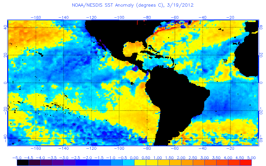
Re: 2013 Steering Pattern / Early indicators
Thanks to the negative NAO that is dominating for the past few weeks the Tropical Atlantic waters are above average. Here is a comparison from January 19 vs March 16. I have to point out that the Gulf of Mexico is cooler on March 16 than on January 19 but that is understandable because of the cooler temperatures that the GOM has been thru.
January 19

March 16

January 19
March 16
0 likes
Visit the Caribbean-Central America Weather Thread where you can find at first post web cams,radars
and observations from Caribbean basin members Click Here
and observations from Caribbean basin members Click Here
-
Hurricaneman
- Category 5
- Posts: 7404
- Age: 45
- Joined: Tue Aug 31, 2004 3:24 pm
- Location: central florida
Re: 2013 Steering Pattern / Early indicators
Atlantic Instability March 20 2013
GOM: Average -8 Current -5 which is 3 above normal instability
Caribbean: Average 0 Current -3 which is 3 below normal instability
East Coast: Average -10 Current -9 which is 1 above normal instability
Tropical Atlantic: Average -7 Current -8 which is 1 below normal instability
Subtrop Atlantic: Average -9 Current -9 which is normal instability
The accumulitive atlantic instability is right at normal
0 likes
-
cycloneye
- Admin
- Posts: 149471
- Age: 69
- Joined: Thu Oct 10, 2002 10:54 am
- Location: San Juan, Puerto Rico
Re: 2013 Steering Pattern / Early indicators
Hurricaneman wrote:Atlantic Instability March 20 2013
GOM: Average -8 Current -5 which is 3 above normal instability
Caribbean: Average 0 Current -3 which is 3 below normal instability
East Coast: Average -10 Current -9 which is 1 above normal instability
Tropical Atlantic: Average -7 Current -8 which is 1 below normal instability
Subtrop Atlantic: Average -9 Current -9 which is normal instability
The accumulitive atlantic instability is right at normal
http://www.ssd.noaa.gov/PS/TROP/TCFP/index.html
How the Tropical Atlantic vertical instability looks in the graphic.

0 likes
Visit the Caribbean-Central America Weather Thread where you can find at first post web cams,radars
and observations from Caribbean basin members Click Here
and observations from Caribbean basin members Click Here
-
TropicalAnalystwx13
- Category 5
- Posts: 2109
- Age: 28
- Joined: Tue Jul 19, 2011 8:20 pm
- Location: Wilmington, NC
- Contact:
A lot of disagreement between vertical instability charts for the eastern Atlantic.
Either way, vertical instability is doing good for this time of the year. It usually starts climbing between mid-March and mid-April. We'll see if that trend starts and continues...if it does, we should see normal values this year.


Either way, vertical instability is doing good for this time of the year. It usually starts climbing between mid-March and mid-April. We'll see if that trend starts and continues...if it does, we should see normal values this year.
0 likes
-
cycloneye
- Admin
- Posts: 149471
- Age: 69
- Joined: Thu Oct 10, 2002 10:54 am
- Location: San Juan, Puerto Rico
Re: 2013 Steering Pattern / Early indicators
The area of convection well SSE of the CV islands has persisted all day (March 21rst) but is very early for strong tropical waves to be around.For sure it will vanish in the next 6-12 hours but with the waters above average in the Eastern Atlantic,it may be a signal that may not be a surprise to see some early waves in the area.
http://www.yr.no/satellitt/afrika.html
http://www.yr.no/satellitt/afrika.html
0 likes
Visit the Caribbean-Central America Weather Thread where you can find at first post web cams,radars
and observations from Caribbean basin members Click Here
and observations from Caribbean basin members Click Here
-
OuterBanker
- S2K Supporter

- Posts: 1761
- Joined: Wed Feb 26, 2003 10:53 am
- Location: Nags Head, NC
- Contact:
Re: 2013 Steering Pattern / Early indicators
Poof factor positive? I looks like the waters directly off the African coast have been consistently warmer this winter into early spring. I can't remember if last year was cooler or warmer this time of year, but we all know that they were cooler during the height of the season. There were countless large well-formed waves over Africa last year that simply went poof as soon as they hit the cooler waters. If these waters stay normal to above average it will no doubt have an effect on early developing long tracking CV storms. Especially if the models that are predicting a moist Sahel region during the season come true.
BTW, thanks for that wonderful link Cycloneye. What a great site.
http://www.yr.no/satellitt/afrika.html
BTW, thanks for that wonderful link Cycloneye. What a great site.
http://www.yr.no/satellitt/afrika.html
0 likes
-
TropicalAnalystwx13
- Category 5
- Posts: 2109
- Age: 28
- Joined: Tue Jul 19, 2011 8:20 pm
- Location: Wilmington, NC
- Contact:
Re: 2013 Steering Pattern / Early indicators
OuterBanker wrote:Poof factor positive? I looks like the waters directly off the African coast have been consistently warmer this winter into early spring. I can't remember if last year was cooler or warmer this time of year, but we all know that they were cooler during the height of the season. There were countless large well-formed waves over Africa last year that simply went poof as soon as they hit the cooler waters. If these waters stay normal to above average it will no doubt have an effect on early developing long tracking CV storms. Especially if the models that are predicting a moist Sahel region during the season come true.
BTW, thanks for that wonderful link Cycloneye. What a great site.
http://www.yr.no/satellitt/afrika.html
Sea surface temperatures in the eastern Atlantic this time last year were well below average:
0 likes
-
Hurricaneman
- Category 5
- Posts: 7404
- Age: 45
- Joined: Tue Aug 31, 2004 3:24 pm
- Location: central florida
Re: 2013 Steering Pattern / Early indicators
The atlantic also has the tri-pole water temp profile where the tropics are above normal, subtropics are below normal and the polar regions are above normal which in most instances lead to a high concentration of storms in the MDR into the Caribbean which leads to a much higher chance of landfalling storms which is something to really keep an eye on as the spring progresses
0 likes
-
cycloneye
- Admin
- Posts: 149471
- Age: 69
- Joined: Thu Oct 10, 2002 10:54 am
- Location: San Juan, Puerto Rico
Re: 2013 Steering Pattern / Early indicators
Hurricaneman wrote:The atlantic also has the tri-pole water temp profile where the tropics are above normal, subtropics are below normal and the polar regions are above normal which in most instances lead to a high concentration of storms in the MDR into the Caribbean which leads to a much higher chance of landfalling storms which is something to really keep an eye on as the spring progresses
Here is a good graphic that shows well the tripole.

0 likes
Visit the Caribbean-Central America Weather Thread where you can find at first post web cams,radars
and observations from Caribbean basin members Click Here
and observations from Caribbean basin members Click Here
-
cycloneye
- Admin
- Posts: 149471
- Age: 69
- Joined: Thu Oct 10, 2002 10:54 am
- Location: San Juan, Puerto Rico
Re: 2013 Steering Pattern / Early indicators
The Tropical Atlantic is trending warmer in past few days but will it persist this way as the hurricane season arrives and gets to the peak?

http://www.tropicaltidbits.com/analysis/
http://www.tropicaltidbits.com/analysis/
0 likes
Visit the Caribbean-Central America Weather Thread where you can find at first post web cams,radars
and observations from Caribbean basin members Click Here
and observations from Caribbean basin members Click Here
-
TropicalAnalystwx13
- Category 5
- Posts: 2109
- Age: 28
- Joined: Tue Jul 19, 2011 8:20 pm
- Location: Wilmington, NC
- Contact:

-
Hurricaneman
- Category 5
- Posts: 7404
- Age: 45
- Joined: Tue Aug 31, 2004 3:24 pm
- Location: central florida
Re: 2013 Steering Pattern / Early indicators
Atlantic instability March 25 2013
GOM: Average -8 Current -18 which is 10 below normal instability
Caribbean: Average 0 Current -1 which is 1 below normal instability
East Coast: Average -11 Current -9 which is 2 above normal instability
Tropical Atlantic: Average -7 Current -7 which is normal instability
Subtrop Atlantic: Average -9 Current -10 which is 1 below normal instability
Overall instability numbers for the entire atlantic is 10 below normal instability
I know this time of year the east coast and GOM are going to be variable until May so those 2 areas are given less creedence until then
0 likes
Who is online
Users browsing this forum: Yellow Evan and 170 guests