Atlantic Sea Surface Temperatures and Anomalies

This is the general tropical discussion area. Anyone can take their shot at predicting a storms path.

Moderator: S2k Moderators

Forum rules

The posts in this forum are NOT official forecasts and should not be used as such. They are just the opinion of the poster and may or may not be backed by sound meteorological data. They are NOT endorsed by any professional institution or STORM2K. For official information, please refer to products from the National Hurricane Center and National Weather Service.

Help Support Storm2K
Message
Author
User avatar
HurricaneB
Tropical Wave
Tropical Wave
Posts: 3
Joined: Thu Mar 31, 2011 5:05 am

Re: Atlantic Sea Surface Temperatures and Anomalies

#541 Postby HurricaneB » Thu May 10, 2012 9:09 pm

I know sea surface temps are only one factor in predicting a hurricane season but I really think we will see some revised numbers soon......they are too low...the gulf is boiling already like never before......this might be one of those came out of nowhere years

May 9 2012 *** NOW ***
Image

May 10 2005
Image

May 9 2008
Image
0 likes   
~Time keeps slipping into the future..~

User avatar
NDG
S2K Supporter
S2K Supporter
Posts: 15446
Joined: Sun Jul 09, 2006 10:14 pm
Location: Orlando, FL

#542 Postby NDG » Mon May 28, 2012 10:09 pm

Maybe a good warm up for the tropical Atlantic? If GFS ensembles are correct this will be the most negative the NAO will be since at least last summer.

Image
0 likes   

User avatar
TheBurn
Category 2
Category 2
Posts: 540
Joined: Thu Jul 28, 2005 4:00 pm
Location: Rincon, PR

Re: Atlantic Sea Surface Temperatures and Anomalies

#543 Postby TheBurn » Fri Jun 01, 2012 6:18 am

SST Map at the start of the Atlantic Season

Image
0 likes   

User avatar
Kingarabian
S2K Supporter
S2K Supporter
Posts: 15981
Joined: Sat Aug 08, 2009 3:06 am
Location: Honolulu, Hawaii

Re: Atlantic Sea Surface Temperatures and Anomalies

#544 Postby Kingarabian » Fri Jun 01, 2012 10:29 pm

TheBurn wrote:SST Map at the start of the Atlantic Season

Image

Barely conducive excluding the Caribbean and the GOM.
0 likes   
RIP Kobe Bryant

User avatar
cycloneye
Admin
Admin
Posts: 145327
Age: 68
Joined: Thu Oct 10, 2002 10:54 am
Location: San Juan, Puerto Rico

Re: Atlantic Sea Surface Temperatures and Anomalies

#545 Postby cycloneye » Mon Jun 04, 2012 10:22 pm

Look how the North Atlantic basin in many areas has been warming since the NAO turned negative. March had the coldest waters. 6 month loop below.

Image
0 likes   
Visit the Caribbean-Central America Weather Thread where you can find at first post web cams,radars
and observations from Caribbean basin members Click Here

User avatar
SFLcane
S2K Supporter
S2K Supporter
Posts: 10163
Age: 47
Joined: Sat Jun 05, 2010 1:44 pm
Location: Lake Worth Florida

Re: Atlantic Sea Surface Temperatures and Anomalies

#546 Postby SFLcane » Mon Jun 04, 2012 10:59 pm

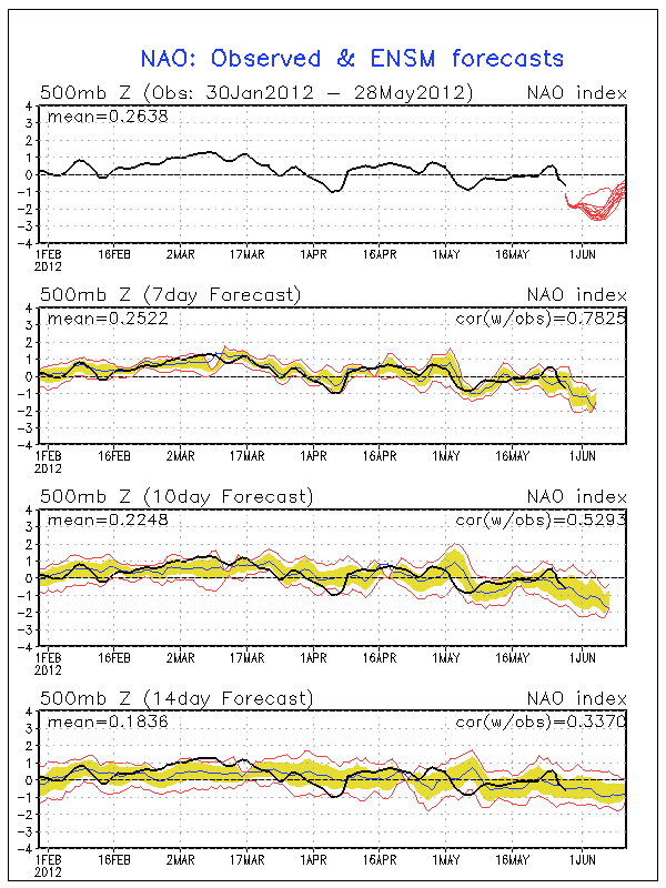
cycloneye wrote:Look how the North Atlantic basin in many areas has been warming since the NAO turned negative. March had the coldest waters. 6 month loop below.

Image


Also take note off the North Atlantic tripole developing a sign of an active season possibly in the cards.
0 likes   

User avatar
NDG
S2K Supporter
S2K Supporter
Posts: 15446
Joined: Sun Jul 09, 2006 10:14 pm
Location: Orlando, FL

#547 Postby NDG » Thu Jun 07, 2012 7:24 am

:uarrow: The average to negative NAO during the last couple of months was something that was not expected by many forecasters.
Now look how warmer (compared to earlier this year) than average the Atlantic Basin is.

Image
0 likes   

User avatar
cycloneye
Admin
Admin
Posts: 145327
Age: 68
Joined: Thu Oct 10, 2002 10:54 am
Location: San Juan, Puerto Rico

Re: Atlantic Sea Surface Temperatures and Anomalies

#548 Postby cycloneye » Thu Jun 07, 2012 10:43 am

For those who may not know what a North Atlantic tripole is as mentioned by our friend SFLcane,here is a graphic about it.

Image
0 likes   
Visit the Caribbean-Central America Weather Thread where you can find at first post web cams,radars
and observations from Caribbean basin members Click Here

User avatar
cycloneye
Admin
Admin
Posts: 145327
Age: 68
Joined: Thu Oct 10, 2002 10:54 am
Location: San Juan, Puerto Rico

Re: Atlantic Sea Surface Temperatures and Anomalies

#549 Postby cycloneye » Sun Jun 17, 2012 8:13 am

The ECMWF continues to forecast -NAO thru the end of June.

Image

And NCEP the same.

Image

This means more warming of the Atlantic waters.
0 likes   
Visit the Caribbean-Central America Weather Thread where you can find at first post web cams,radars
and observations from Caribbean basin members Click Here

User avatar
NDG
S2K Supporter
S2K Supporter
Posts: 15446
Joined: Sun Jul 09, 2006 10:14 pm
Location: Orlando, FL

#550 Postby NDG » Sun Jun 17, 2012 8:18 am

:uarrow: Hmm, continuing negative NAO with neutral ENSO conditions, could be a busier than average next couple of months across the basin, IMO.
0 likes   

User avatar
cycloneye
Admin
Admin
Posts: 145327
Age: 68
Joined: Thu Oct 10, 2002 10:54 am
Location: San Juan, Puerto Rico

Re: Atlantic Sea Surface Temperatures and Anomalies

#551 Postby cycloneye » Sat Apr 20, 2013 1:08 pm

Bumping this thread to see how things stand in the sst,s and ssta,s.

Image

Image
0 likes   
Visit the Caribbean-Central America Weather Thread where you can find at first post web cams,radars
and observations from Caribbean basin members Click Here

User avatar
TropicalAnalystwx13
Category 5
Category 5
Posts: 2109
Age: 27
Joined: Tue Jul 19, 2011 8:20 pm
Location: Wilmington, NC
Contact:

#552 Postby TropicalAnalystwx13 » Sat Apr 20, 2013 1:29 pm

I was reading some of the posts above and should note that a negative NAO does not automatically guarantee a warming Atlantic, and a positive NAO does not automatically guarantee a cooling Atlantic; sometimes these are switched. For example...

We are currently in the postive NAO phase, and it's quite potent as well...the highest we've seen in well over several months. However, because the dipole -- the separation of positive/negative charges, in this case the separation of below and above-average trade winds -- has shifted farther north, very weak trade winds encompass, and are forecast to encompass, much of the tropical Atlantic and MDR through the end of this month. This is leading to a substantial warm-up.
0 likes   

User avatar
artist
Category 5
Category 5
Posts: 9792
Joined: Mon Jun 06, 2005 3:26 pm
Location: West Palm

Re:

#553 Postby artist » Sun Apr 21, 2013 8:13 pm

TropicalAnalystwx13 wrote:I was reading some of the posts above and should note that a negative NAO does not automatically guarantee a warming Atlantic, and a positive NAO does not automatically guarantee a cooling Atlantic; sometimes these are switched. For example...

We are currently in the postive NAO phase, and it's quite potent as well...the highest we've seen in well over several months. However, because the dipole -- the separation of positive/negative charges, in this case the separation of below and above-average trade winds -- has shifted farther north, very weak trade winds encompass, and are forecast to encompass, much of the tropical Atlantic and MDR through the end of this month. This is leading to a substantial warm-up.


thanks for that descriptive post.
0 likes   

User avatar
cycloneye
Admin
Admin
Posts: 145327
Age: 68
Joined: Thu Oct 10, 2002 10:54 am
Location: San Juan, Puerto Rico

Re: Atlantic Sea Surface Temperatures and Anomalies

#554 Postby cycloneye » Mon Apr 22, 2013 7:20 am

The April 22nd update. No change to the warmer than average Tropical Atlantic.

Image
0 likes   
Visit the Caribbean-Central America Weather Thread where you can find at first post web cams,radars
and observations from Caribbean basin members Click Here

User avatar
Hurricane Andrew
S2K Supporter
S2K Supporter
Posts: 1891
Age: 26
Joined: Sun May 23, 2010 2:53 pm
Location: KS

#555 Postby Hurricane Andrew » Mon Apr 22, 2013 3:06 pm

Hotbed of trouble. We need to keep an eye on this. Any early-season waves headed across, on the normal April-ITCZ latitude?

(At least I think waves travel year-round, even when the ITCZ sinks south.)
0 likes   

The Enthusiast
NREMT-AEMT, WX nerd

Irene '11, Sandy '12, Irma '17 (SAR)

"Hard to think we were born to live this way..." -Wage War

User avatar
cycloneye
Admin
Admin
Posts: 145327
Age: 68
Joined: Thu Oct 10, 2002 10:54 am
Location: San Juan, Puerto Rico

Re: Atlantic Sea Surface Temperatures and Anomalies

#556 Postby cycloneye » Mon Apr 22, 2013 3:10 pm

There is another warmup starting.

Image

Image
0 likes   
Visit the Caribbean-Central America Weather Thread where you can find at first post web cams,radars
and observations from Caribbean basin members Click Here

HurricaneFan
Tropical Storm
Tropical Storm
Posts: 192
Age: 41
Joined: Tue Jan 18, 2011 6:16 pm
Location: Anguilla,Leeward Islands 18.3N 63.0W

Re: Atlantic Sea Surface Temperatures and Anomalies

#557 Postby HurricaneFan » Mon Apr 22, 2013 5:23 pm

Is it normal for the cold part of Atlantic Tripole to reach the NE Caribbean?And how long will it last?
0 likes   

User avatar
cycloneye
Admin
Admin
Posts: 145327
Age: 68
Joined: Thu Oct 10, 2002 10:54 am
Location: San Juan, Puerto Rico

Re: Atlantic Sea Surface Temperatures and Anomalies

#558 Postby cycloneye » Mon Apr 22, 2013 5:43 pm

HurricaneFan wrote:Is it normal for the cold part of Atlantic Tripole to reach the NE Caribbean?And how long will it last?


If the NAO goes negative soon as forecast then things will warm in the NE Caribbean waters where is not so warm.

Image
0 likes   
Visit the Caribbean-Central America Weather Thread where you can find at first post web cams,radars
and observations from Caribbean basin members Click Here

USTropics
Professional-Met
Professional-Met
Posts: 2651
Joined: Sun Aug 12, 2007 3:45 am
Location: Florida State University

Re: Atlantic Sea Surface Temperatures and Anomalies

#559 Postby USTropics » Tue Apr 23, 2013 7:31 pm

Before it gets busy on here, just wanted to throw some thanks to Cycloneye for doing an amazing job like usual with the continuous updates throughout the off season. He is always spot on.

Also to add some more insight to what most of us are expecting to happen here shortly (a quick ramp up of SSTAs), I've been looking at the GFS ensembles 10m zonal wind anomaly 7 day average the past week. Here is an image from a week ago:
Image

Now compare that to the most current run and you'll see massive zonal wind anomaly developing across the MDR and the East Atlantic:
Image

The GEM ensembles also is in agreement:
Image

What does all this mean? We should see a significant drop in the trade winds as a cutoff low replaces the current position of the subtropical ridge. Since trade winds act as a cooling mechanism to the SSTs, with slow to nonexistent trade winds an increase in SSTAs is expected in the MDR to East Atlantic region through at least the next 2 weeks. This is also what TropicalAnalystwx13 and others have been eluding to from the weekend conversation.

This is a link to the models of the graphics that I used:
http://www.tropicaltidbits.com/analysis/models/
0 likes   

User avatar
cycloneye
Admin
Admin
Posts: 145327
Age: 68
Joined: Thu Oct 10, 2002 10:54 am
Location: San Juan, Puerto Rico

Re: Atlantic Sea Surface Temperatures and Anomalies

#560 Postby cycloneye » Thu Apr 25, 2013 3:44 pm

Here is the latest MDR data.

Image

Image
0 likes   
Visit the Caribbean-Central America Weather Thread where you can find at first post web cams,radars
and observations from Caribbean basin members Click Here


Return to “Talkin' Tropics”

Who is online

Users browsing this forum: No registered users and 20 guests