Discussion (May 18-19-20-21) Moore Tornado EF-5 from NWS
Moderator: S2k Moderators
Forum rules

The posts in this forum are NOT official forecast and should not be used as such. They are just the opinion of the poster and may or may not be backed by sound meteorological data. They are NOT endorsed by any professional institution or STORM2K.

I'm in shock
cycloneye wrote:Wow,look at this photo of tornado in SW Rozel Kansas. You have another option to post videos and photos and that is in the Sticky 2013 U.S Severe Weather Season (Videos-Photos-Stats-Forecast thread

HOLY CRAP!!!!!!!
Seymour TX tornado of April 10 1979:

0 likes
-
cycloneye

- Admin

- Posts: 149368
- Age: 69
- Joined: Thu Oct 10, 2002 10:54 am
- Location: San Juan, Puerto Rico
Re: Severe Weather Outbreak for May 18-19-20 (Watches/Warnings)
Bunkertor wrote:

I moved the post you made at the watches and warnings thread to this one.
0 likes
Visit the Caribbean-Central America Weather Thread where you can find at first post web cams,radars
and observations from Caribbean basin members Click Here
and observations from Caribbean basin members Click Here

-
cycloneye
- Admin
- Posts: 149368
- Age: 69
- Joined: Thu Oct 10, 2002 10:54 am
- Location: San Juan, Puerto Rico
Re: Discussion of Severe Weather Outbreak for May 18-19-20
Cyclenall,that is why I posted that photo at the sticky thread to continue to document the 2013 season with those extraordinary photos.
0 likes
Visit the Caribbean-Central America Weather Thread where you can find at first post web cams,radars
and observations from Caribbean basin members Click Here
and observations from Caribbean basin members Click Here
-
cycloneye
- Admin
- Posts: 149368
- Age: 69
- Joined: Thu Oct 10, 2002 10:54 am
- Location: San Juan, Puerto Rico
Re: Discussion of Severe Weather Outbreak for May 18-19-20
Reports so far on May 18 of Tornadoes,Wind and Hail.

0 likes
Visit the Caribbean-Central America Weather Thread where you can find at first post web cams,radars
and observations from Caribbean basin members Click Here
and observations from Caribbean basin members Click Here
-
CrazyC83
- Professional-Met

- Posts: 34315
- Joined: Tue Mar 07, 2006 11:57 pm
- Location: Deep South, for the first time!
Re: Discussion of Severe Weather Outbreak for May 18-19-20
Yet that tornado will likely go down as an EF-0 since I haven't heard of any damage.
0 likes
-
WeatherGuesser
- Category 5

- Posts: 2672
- Joined: Tue Jun 29, 2010 6:46 am


Re:
CrazyC83 wrote:How will today's under-performance (or at least under-reporting) play into tomorrow? A morning MCS could either make things more prime by adding shear lines or kill the instability completely...
Worthy of a High Risk?
I would not put a high risk. High risk should be reserved for the classic jet streak outbreaks. We are not working with a strong upper wind pattern to make use of the parameters. A localized event certainly! However I would take each day differently as timing, the way these shortwaves eject and not be too worked up on instability or what occurred the day before. I have to say it again, this is not the look of the classic outbreaks where storms fire off a triple point and long track tornadoes travel along a warm front. It is highly dependent on the dry-line and if storms move into the best conditions at the right time.
0 likes
The above post and any post by Ntxw is NOT an official forecast and should not be used as such. It is just the opinion of the poster and may or may not be backed by sound meteorological data. It is NOT endorsed by any professional institution including Storm2k. For official information, please refer to NWS products.
Help support Storm2K!
-
WeatherGuesser
- Category 5
- Posts: 2672
- Joined: Tue Jun 29, 2010 6:46 am
Moderate for Monday now. That makes 3 consecutive Moderate days.
Day 3 (TUE) Slight Risk area is literally from Canada to Mexico
SPC AC 190600
DAY 2 CONVECTIVE OUTLOOK
NWS STORM PREDICTION CENTER NORMAN OK
0100 AM CDT SUN MAY 19 2013
VALID 201200Z - 211200Z
...THERE IS A MDT RISK OF SVR TSTMS FROM PARTS OF SERN KS/W CENTRAL
AND SWRN MO SWWD INTO CENTRAL OK...
...THERE IS A SLGT RISK OF SVR TSTMS FROM THE UPPER MS VALLEY/UPPER
GREAT LAKES REGION SSWWD INTO N CENTRAL TX...
...SYNOPSIS...
A LARGE UPPER LOW IS FORECAST TO LINGER IN PLACE ACROSS THE SD/NEB
VICINITY...WHILE A MID-LEVEL JET STREAK AROUND THE SRN FRINGE OF THE
LOW EJECTS FROM THE SRN ROCKIES INTO THE CENTRAL U.S. DURING THE
PERIOD. WHILE A SECOND LOW/TROUGH IS FORECAST TO APPROACH THE PAC
NW COAST LATE...THE CENTRAL U.S. STORM SYSTEM WILL BE THE SYSTEM OF
INTEREST WITH RESPECT TO SEVERE POTENTIAL ON MONDAY.
AT THE SURFACE...A LOW IS FORECAST TO REMAIN OVER THE SD VICINITY
BENEATH THE UPPER LOW...WITH A TRAILING COLD FRONT FORECAST TO SHIFT
EWD ACROSS THE PLAINS. AS THE AFOREMENTIONED JET STREAK SHIFTS INTO
THE S CENTRAL PORTION OF THE COUNTRY...SECONDARY CYCLOGENESIS IS
FORECAST TO OCCUR ALONG THE FRONT IN THE SWRN OK VICINITY...NEAR THE
INTERSECTION OF THE FRONT AND A DEVELOPING DRYLINE. THE COLD FRONT
AND DRYLINE SHOULD SERVE AS PRIMARY FOCI FOR AFTERNOON DEVELOPMENT
OF WIDESPREAD/SEVERE STORMS.
...UPPER MS VALLEY/UPPER GREAT LAKES SWWD INTO THE SRN PLAINS...
WHILE DETAILS REMAIN DIFFICULT TO DISCERN DUE TO MULTIPLE ROUNDS OF
WIDESPREAD/INTERVENING CONVECTION...ANOTHER SUBSTANTIAL SEVERE
WEATHER EVENT IS FORECAST MONDAY/DAY 2 ACROSS THE CENTRAL CONUS.
WEAKENING/DIMINISHING CONVECTION MAY BE ONGOING AHEAD OF THE FRONT
ACROSS THE WARM SECTOR...BUT AS STORMS/CLOUDINESS WANE THROUGH THE
MORNING IN MOST AREAS...EXPECT THE ONSET OF HEATING TO DRIVE STRONG
AIRMASS DESTABILIZATION. BY LATE AFTERNOON...THE
PRE-FRONTAL/PRE-DRYLINE WARM SECTOR SHOULD FEATURE 2500 TO 3500 J/KG
MIXED-LAYER CAPE. AS LARGE-SCALE ASCENT -- AIDED BY THE APPROACHING
JET STREAK AND FOCUSED ALONG LOW-LEVEL BOUNDARIES --
INCREASES...EXPECT DEVELOPMENT/RAPID GROWTH OF INITIAL CONVECTION
DURING THE MID AFTERNOON HOURS. AS SHEAR INCREASES IN CONJUNCTION
WITH INTENSIFYING FLOW ALOFT...STORMS SHOULD RAPIDLY ACQUIRE
ROTATION -- PARTICULARLY WHERE CAPE/SHEAR JUXTAPOSITION APPEARS MOST
FAVORABLE ACROSS THE MDT RISK AREA. HERE...THREAT FOR VERY LARGE
HAIL AND TORNADOES WILL EXIST. THREAT FOR DAMAGING WINDS WILL
INCREASE INTO THE EVENING...AS STORMS EVOLVE INTO LINEAR CLUSTERS IN
SOME AREAS. EVEN SO...ROTATING/SUPERCELL STORMS SHOULD LINGER
LOCALLY WELL INTO THE EVENING HOURS -- WITH CONTINUED TORNADO AND
LARGE HAIL POTENTIAL. THREAT SHOULD FINALLY BEGIN TO DIMINISH
OVERNIGHT...AS THE AIRMASS SLOWLY COOLS/STABILIZES -- PARTICULARLY
ACROSS NRN PORTIONS OF THE RISK AREA.
..GOSS.. 05/19/2013
Day 3 (TUE) Slight Risk area is literally from Canada to Mexico
0 likes
-
wx247

- S2K Supporter

- Posts: 14279
- Age: 42
- Joined: Wed Feb 05, 2003 10:35 pm
- Location: Monett, Missouri
- Contact:
Re: Re:
Ntxw wrote:CrazyC83 wrote:How will today's under-performance (or at least under-reporting) play into tomorrow? A morning MCS could either make things more prime by adding shear lines or kill the instability completely...
Worthy of a High Risk?
I would not put a high risk. High risk should be reserved for the classic jet streak outbreaks. We are not working with a strong upper wind pattern to make use of the parameters. A localized event certainly! However I would take each day differently as timing, the way these shortwaves eject and not be too worked up on instability or what occurred the day before. I have to say it again, this is not the look of the classic outbreaks where storms fire off a triple point and long track tornadoes travel along a warm front. It is highly dependent on the dry-line and if storms move into the best conditions at the right time.
Agreed. High risk days from the SPC are reserved for those classic setups. This isn't really one of those. There still remain some model discrepancies, too, which worries forecasters. That being said... today looks to be a dangerous day and with the numerous outdoor activities going on across the area, I hope everyone is paying attention to the weather, too. We shall see how things progress throughout the day.
0 likes
Personal Forecast Disclaimer:
The posts in this forum are NOT official forecast and should not be used as such. They are just the opinion of the poster and may or may not be backed by sound meteorological data. They are NOT endorsed by any professional institution or storm2k.org. For official information, please refer to the NHC and NWS products.
The posts in this forum are NOT official forecast and should not be used as such. They are just the opinion of the poster and may or may not be backed by sound meteorological data. They are NOT endorsed by any professional institution or storm2k.org. For official information, please refer to the NHC and NWS products.

-
wx247
- S2K Supporter
- Posts: 14279
- Age: 42
- Joined: Wed Feb 05, 2003 10:35 pm
- Location: Monett, Missouri
- Contact:
Re:
RL3AO wrote:Its a mid-level moderate day.
RL... I was kind of in the same camp with you when I first got up, but looking at the latest data this morning I am a bit more concerned. Latest indications are this may be a bit more than that... although not quite a high risk. Seems the NAM is out to lunch based upon the surface features this morning. Accordingly, SPC has upped the ante just a bit with their latest tornado progs in the last hour.
Maybe I am just a bit more on edge because Joplin High School's graduation is today and being from the area and remembering all too well the nightmare of 5/22/11... I will anxiously be following the situation as it unfolds today.
0 likes
Personal Forecast Disclaimer:
The posts in this forum are NOT official forecast and should not be used as such. They are just the opinion of the poster and may or may not be backed by sound meteorological data. They are NOT endorsed by any professional institution or storm2k.org. For official information, please refer to the NHC and NWS products.
The posts in this forum are NOT official forecast and should not be used as such. They are just the opinion of the poster and may or may not be backed by sound meteorological data. They are NOT endorsed by any professional institution or storm2k.org. For official information, please refer to the NHC and NWS products.
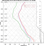
Joplin forecast soundings
RAP (23z)
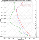
NAM (0z)
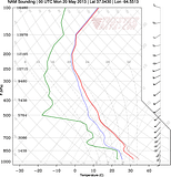
GFS (0z)
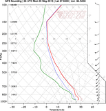
RAP/NAM are pretty good looking but nothing that screams high risk.
However, this is around Tulsa at 3z. Appears to be much more of a higher end moderate risk sounding. Super high instability and some due south winds at the lower level instead of SSW. One of the negatives could be lower dewpoints near the surface creating higher lcl's.

0 likes
-
SouthDadeFish

- Professional-Met
- Posts: 2835
- Joined: Thu Sep 23, 2010 2:54 pm
- Location: Miami, FL
- Contact:

-
cycloneye
- Admin
- Posts: 149368
- Age: 69
- Joined: Thu Oct 10, 2002 10:54 am
- Location: San Juan, Puerto Rico
Re: Discussion of Severe Weather Outbreak for May 18-19-20
Boundaries are present and those may serve as trigger for tronadic activity later this afternoon and evening.

0 likes
Visit the Caribbean-Central America Weather Thread where you can find at first post web cams,radars
and observations from Caribbean basin members Click Here
and observations from Caribbean basin members Click Here
-
TropicalAnalystwx13

- Category 5
- Posts: 2109
- Age: 28
- Joined: Tue Jul 19, 2011 8:20 pm
- Location: Wilmington, NC
- Contact:
Return to “USA & Caribbean Weather”
Who is online
Users browsing this forum: AnnularCane, HurricaneBelle and 67 guests