Tornado Probabilities are the same in this watch:
DISCUSSION...THE INITIATION OF DISCRETE SUPERCELLS APPEARS LIKELY
ALONG THE DRYLINE ACROSS CENTRAL OKLAHOMA DURING THE NEXT FEW
HOURS...BEFORE ADVECTING AWAY FROM THE DRYLINE ON 40-50 KT DEEP
LAYER SOUTHWESTERLY MEAN FLOW. AS ACTIVITY PROGRESSES THROUGH A
MOIST UNSTABLE BOUNDARY LAYER WITH SIZABLE CAPE...THE RISK FOR VERY
LARGE HAIL AND TORNADOES IS EXPECTED TO INCREASE THROUGH THE EVENING
HOURS. BY EARLY EVENING...A STRENGTHENING SOUTHERLY LOW-LEVEL JET
WILL CONTINUE TO ENLARGE LOW-LEVEL HODOGRAPHS...MAINTAINING THE RISK
FOR TORNADOES ACROSS EASTERN OKLAHOMA. A COUPLE OF LONG-LIVED/LONG
TRACK SUPERCELLS ARE POSSIBLE...WITH A RISK FOR A FEW STRONG
TORNADOES.
Discussion (May 18-19-20-21) Moore Tornado EF-5 from NWS
Moderator: S2k Moderators
Forum rules

The posts in this forum are NOT official forecast and should not be used as such. They are just the opinion of the poster and may or may not be backed by sound meteorological data. They are NOT endorsed by any professional institution or STORM2K.
-
wx247

- S2K Supporter

- Posts: 14279
- Age: 42
- Joined: Wed Feb 05, 2003 10:35 pm
- Location: Monett, Missouri
- Contact:
0 likes
Personal Forecast Disclaimer:
The posts in this forum are NOT official forecast and should not be used as such. They are just the opinion of the poster and may or may not be backed by sound meteorological data. They are NOT endorsed by any professional institution or storm2k.org. For official information, please refer to the NHC and NWS products.
The posts in this forum are NOT official forecast and should not be used as such. They are just the opinion of the poster and may or may not be backed by sound meteorological data. They are NOT endorsed by any professional institution or storm2k.org. For official information, please refer to the NHC and NWS products.


-
TwisterFanatic

- Category 5

- Posts: 1041
- Joined: Mon Jun 28, 2010 12:43 pm
- Location: Sallisaw, Oklahoma
Storm near the Wichita area is really taking off bigtime.
0 likes
Personal Forecast Disclaimer:
The posts in this forum are NOT official forecast and should not be used as such. They are just the opinion of the poster and may or may not be backed by sound meteorological data. They are NOT endorsed by any professional institution or storm2k.org. For official information, please refer to the NHC and NWS products.
The posts in this forum are NOT official forecast and should not be used as such. They are just the opinion of the poster and may or may not be backed by sound meteorological data. They are NOT endorsed by any professional institution or storm2k.org. For official information, please refer to the NHC and NWS products.
-
wx247
- S2K Supporter
- Posts: 14279
- Age: 42
- Joined: Wed Feb 05, 2003 10:35 pm
- Location: Monett, Missouri
- Contact:
Storms also beginning to fire further south with one trying to go up west of OKC.
0 likes
Personal Forecast Disclaimer:
The posts in this forum are NOT official forecast and should not be used as such. They are just the opinion of the poster and may or may not be backed by sound meteorological data. They are NOT endorsed by any professional institution or storm2k.org. For official information, please refer to the NHC and NWS products.
The posts in this forum are NOT official forecast and should not be used as such. They are just the opinion of the poster and may or may not be backed by sound meteorological data. They are NOT endorsed by any professional institution or storm2k.org. For official information, please refer to the NHC and NWS products.
-
TwisterFanatic
- Category 5
- Posts: 1041
- Joined: Mon Jun 28, 2010 12:43 pm
- Location: Sallisaw, Oklahoma
Cumulus field blowing up along the dryline.
0 likes
Personal Forecast Disclaimer:
The posts in this forum are NOT official forecast and should not be used as such. They are just the opinion of the poster and may or may not be backed by sound meteorological data. They are NOT endorsed by any professional institution or storm2k.org. For official information, please refer to the NHC and NWS products.
The posts in this forum are NOT official forecast and should not be used as such. They are just the opinion of the poster and may or may not be backed by sound meteorological data. They are NOT endorsed by any professional institution or storm2k.org. For official information, please refer to the NHC and NWS products.

-
TwisterFanatic
- Category 5
- Posts: 1041
- Joined: Mon Jun 28, 2010 12:43 pm
- Location: Sallisaw, Oklahoma
Confirmed brief tornado with Wichita cell.
0 likes
Personal Forecast Disclaimer:
The posts in this forum are NOT official forecast and should not be used as such. They are just the opinion of the poster and may or may not be backed by sound meteorological data. They are NOT endorsed by any professional institution or storm2k.org. For official information, please refer to the NHC and NWS products.
The posts in this forum are NOT official forecast and should not be used as such. They are just the opinion of the poster and may or may not be backed by sound meteorological data. They are NOT endorsed by any professional institution or storm2k.org. For official information, please refer to the NHC and NWS products.
-
apocalypt-flyer
- Category 1

- Posts: 468
- Joined: Sat Aug 27, 2005 11:51 am
Re: Discussion of Severe Weather Outbreak for May 18-19-20
Rope tornado on the ground just north-east of Clearwater, south-west of Wichita. Lifting in and out.
0 likes
-
TwisterFanatic
- Category 5
- Posts: 1041
- Joined: Mon Jun 28, 2010 12:43 pm
- Location: Sallisaw, Oklahoma
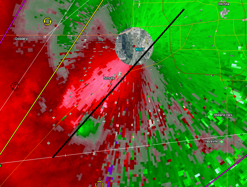
2nd touchdown confirmed. Track is gonna come real close to downtown Wichita.
0 likes
Personal Forecast Disclaimer:
The posts in this forum are NOT official forecast and should not be used as such. They are just the opinion of the poster and may or may not be backed by sound meteorological data. They are NOT endorsed by any professional institution or storm2k.org. For official information, please refer to the NHC and NWS products.
The posts in this forum are NOT official forecast and should not be used as such. They are just the opinion of the poster and may or may not be backed by sound meteorological data. They are NOT endorsed by any professional institution or storm2k.org. For official information, please refer to the NHC and NWS products.

-
TwisterFanatic
- Category 5
- Posts: 1041
- Joined: Mon Jun 28, 2010 12:43 pm
- Location: Sallisaw, Oklahoma
Very impressive couplet in the last frame.
0 likes
Personal Forecast Disclaimer:
The posts in this forum are NOT official forecast and should not be used as such. They are just the opinion of the poster and may or may not be backed by sound meteorological data. They are NOT endorsed by any professional institution or storm2k.org. For official information, please refer to the NHC and NWS products.
The posts in this forum are NOT official forecast and should not be used as such. They are just the opinion of the poster and may or may not be backed by sound meteorological data. They are NOT endorsed by any professional institution or storm2k.org. For official information, please refer to the NHC and NWS products.
Re: Discussion of Severe Weather Outbreak for May 18-19-20
...A TORNADO WARNING REMAINS IN EFFECT FOR SOUTHERN SEDGWICK COUNTY
UNTIL 415 PM CDT...
AT 336 PM CDT...A CONFIRMED LARGE AND EXTREMELY DANGEROUS TORNADO WAS
LOCATED NEAR WICHITA MID CONTINENT AIRPORT...AND MOVING NORTHEAST AT
30 MPH.
THIS IS A PARTICULARLY DANGEROUS SITUATION.
HAZARD...DAMAGING TORNADO.
SOURCE...WEATHER SPOTTERS CONFIRMED TORNADO.
UNTIL 415 PM CDT...
AT 336 PM CDT...A CONFIRMED LARGE AND EXTREMELY DANGEROUS TORNADO WAS
LOCATED NEAR WICHITA MID CONTINENT AIRPORT...AND MOVING NORTHEAST AT
30 MPH.
THIS IS A PARTICULARLY DANGEROUS SITUATION.
HAZARD...DAMAGING TORNADO.
SOURCE...WEATHER SPOTTERS CONFIRMED TORNADO.
0 likes
Return to “USA & Caribbean Weather”
Who is online
Users browsing this forum: No registered users and 105 guests