Discussion (May 18-19-20-21) Moore Tornado EF-5 from NWS
Moderator: S2k Moderators
Forum rules

The posts in this forum are NOT official forecast and should not be used as such. They are just the opinion of the poster and may or may not be backed by sound meteorological data. They are NOT endorsed by any professional institution or STORM2K.


-
apocalypt-flyer
- Category 1

- Posts: 468
- Joined: Sat Aug 27, 2005 11:51 am
-
apocalypt-flyer
- Category 1
- Posts: 468
- Joined: Sat Aug 27, 2005 11:51 am


-
cycloneye

- Admin

- Posts: 149503
- Age: 69
- Joined: Thu Oct 10, 2002 10:54 am
- Location: San Juan, Puerto Rico
Re:
EF-5bigj wrote:Violent tornadoes at night
The worse case scenario.
0 likes
Visit the Caribbean-Central America Weather Thread where you can find at first post web cams,radars
and observations from Caribbean basin members Click Here
and observations from Caribbean basin members Click Here
-
wx247

- S2K Supporter

- Posts: 14279
- Age: 42
- Joined: Wed Feb 05, 2003 10:35 pm
- Location: Monett, Missouri
- Contact:
This is an awful situation. Prayers for all affected.
0 likes
Personal Forecast Disclaimer:
The posts in this forum are NOT official forecast and should not be used as such. They are just the opinion of the poster and may or may not be backed by sound meteorological data. They are NOT endorsed by any professional institution or storm2k.org. For official information, please refer to the NHC and NWS products.
The posts in this forum are NOT official forecast and should not be used as such. They are just the opinion of the poster and may or may not be backed by sound meteorological data. They are NOT endorsed by any professional institution or storm2k.org. For official information, please refer to the NHC and NWS products.
Re:
CrazyC83 wrote:This is ugly to say the least. And a sign they will keep going especially with the LLJ. Could a rare case of a High Risk upgrade at 0100Z take place?
Hm, considering the time and the numbers in southern OK, high would not be wrong, but i doubt it.
0 likes
TORCON
AR northwest - 5
IA west - 4
IA central - 5
IA southeast - 3 to 4
IL west-central, northwest - 3
KS central - 4
KS southeast - 7
KS northeast - 6
MN south - 2
MO north - 4
MO central - 4 to 5
MO southwest - 5 to 6
NE east half, southwest - 2
OK north-central, northeast - 7
OK south-central - 4 to 5
OK west except panhandle - 2
SD east - 2
TX north-central - 3
WI west-central, southwest - 4
other areas - less than 2
Does anyone know when they do updates ?
0 likes
-
TropicalAnalystwx13

- Category 5

- Posts: 2109
- Age: 28
- Joined: Tue Jul 19, 2011 8:20 pm
- Location: Wilmington, NC
- Contact:
Re:
CrazyC83 wrote:This is ugly to say the least. And a sign they will keep going especially with the LLJ. Could a rare case of a High Risk upgrade at 0100Z take place?
Discrete cells won't be as much of an issue from here on out. That isn't to say the tornado threat isn't there..it most definitely is...but the worst of the tornado outbreak is over for today.
Widespread severe weather is likely throughout the night.
0 likes
-
TropicalAnalystwx13
- Category 5
- Posts: 2109
- Age: 28
- Joined: Tue Jul 19, 2011 8:20 pm
- Location: Wilmington, NC
- Contact:
Re:
psyclone wrote:those pics on TWC look like EF-3 or EF-4 type destruction depending on exactly what they were....looks like single family homes. pretty horrendous.
It was a mobile home park.
0 likes
-
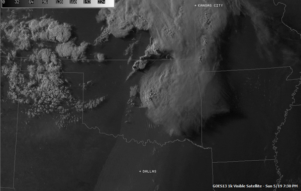
apocalypt-flyer
- Category 1
- Posts: 468
- Joined: Sat Aug 27, 2005 11:51 am
Re:
Here's a nice picture where you can see where the dryline was at at 7.30pm. From @Tornadoquest on twitter.
0 likes
-
Texas Snowman

- Storm2k Moderator

- Posts: 6197
- Joined: Fri Jan 25, 2008 11:29 am
- Location: Denison, Texas
I've seen some reports of the "earth scoured" near Shawnee. Wonder if that tornado might have briefly been EF-5?
0 likes
The above post and any post by Texas Snowman is NOT an official forecast and should not be used as such. It is just the opinion of the poster and may or may not be backed by sound meteorological data. It is NOT endorsed by any professional institution including storm2k.org. For official information, please refer to NWS products.
Return to “USA & Caribbean Weather”
Who is online
Users browsing this forum: No registered users and 99 guests