You know when I got back home just now after being to a birthday for 4 hours and saw the page count jump into the twenties I knew something went down.
But a 2 mile wide wedge going through Moore was way outside of what I thought could've happened.
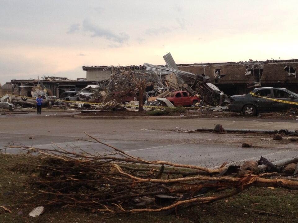
As I said yesterday that city cannot catch a break. Absolutely shocking pictures. There's just NOTHING left. 1999-like levelling. Probably worse.
Discussion (May 18-19-20-21) Moore Tornado EF-5 from NWS
Moderator: S2k Moderators
Forum rules

The posts in this forum are NOT official forecast and should not be used as such. They are just the opinion of the poster and may or may not be backed by sound meteorological data. They are NOT endorsed by any professional institution or STORM2K.
-
apocalypt-flyer
- Category 1

- Posts: 468
- Joined: Sat Aug 27, 2005 11:51 am
-
Texas Snowman

- Storm2k Moderator

- Posts: 6197
- Joined: Fri Jan 25, 2008 11:29 am
- Location: Denison, Texas
@JimCantore: Radio reports of people using social media asking for help to be dug out from rubble. @nbcnightlynews
0 likes
The above post and any post by Texas Snowman is NOT an official forecast and should not be used as such. It is just the opinion of the poster and may or may not be backed by sound meteorological data. It is NOT endorsed by any professional institution including storm2k.org. For official information, please refer to NWS products.


Re:
Texas Snowman wrote:Mind boggling time-lapse video of the Moore tornado:
http://www.wmctv.com/category/240217/video-landing-page?autoStart=true&topVideoCatNo=default&clipId=8899079
Ugh, that´s the Rope-Tornado i was reporting. It just switched from rope to wedge in 20 seconds. And i thought i was tracking the "wrong" tornado...
0 likes


-
Texas Snowman
- Storm2k Moderator
- Posts: 6197
- Joined: Fri Jan 25, 2008 11:29 am
- Location: Denison, Texas
@THESarahD29: Heart-wrenching & unbelievable... RT @TWCMattSampson: A mass casualty situation in #Moore, #Oklahoma. National Guard activated. #OKwx
Lance West of KFOR just broke up, said he has reason to believe they have found "victims" in the Plaza elementary school. Said a medic put his head down and couldn't confirm.
Lance West of KFOR just broke up, said he has reason to believe they have found "victims" in the Plaza elementary school. Said a medic put his head down and couldn't confirm.
0 likes
The above post and any post by Texas Snowman is NOT an official forecast and should not be used as such. It is just the opinion of the poster and may or may not be backed by sound meteorological data. It is NOT endorsed by any professional institution including storm2k.org. For official information, please refer to NWS products.
-
Texas Snowman
- Storm2k Moderator
- Posts: 6197
- Joined: Fri Jan 25, 2008 11:29 am
- Location: Denison, Texas
@ConvectiveWX: RT @JedCastles I've never seen anything like this... Cars thrown on buildings.. ~ Betsy Randolph Oklahoma Highway Patrol.
Moore has issued an "All Call" for first responders to assist. I think I saw that that may even be a statewide "All Call."
Moore has issued an "All Call" for first responders to assist. I think I saw that that may even be a statewide "All Call."
0 likes
The above post and any post by Texas Snowman is NOT an official forecast and should not be used as such. It is just the opinion of the poster and may or may not be backed by sound meteorological data. It is NOT endorsed by any professional institution including storm2k.org. For official information, please refer to NWS products.
-
brunota2003

- S2K Supporter

- Posts: 9476
- Age: 35
- Joined: Sat Jul 30, 2005 9:56 pm
- Location: Stanton, KY...formerly Havelock, NC
- Contact:
-
brunota2003
- S2K Supporter
- Posts: 9476
- Age: 35
- Joined: Sat Jul 30, 2005 9:56 pm
- Location: Stanton, KY...formerly Havelock, NC
- Contact:
Re:
Texas Snowman wrote:@ConvectiveWX: RT @JedCastles I've never seen anything like this... Cars thrown on buildings.. ~ Betsy Randolph Oklahoma Highway Patrol.
Moore has issued an "All Call" for first responders to assist. I think I saw that that may even be a statewide "All Call."
Anyone that has first responder credentials and can get on scene, they need. They don't care much what state you're from.
0 likes
Just a small town southern boy helping other humans.

-
Texas Snowman
- Storm2k Moderator
- Posts: 6197
- Joined: Fri Jan 25, 2008 11:29 am
- Location: Denison, Texas
Re:
brunota2003 wrote:"7 critical, 7 serious and 5 in fair condition. One is a child." Preliminary injury status, just from people they've found so far.
Governor told TWC that she expects "many" fatalities.
One OKC weather guy or reporter said he thinks this is 3X worse than the 1999 tornado (he covered that one too).
I've heard that at its widest, it may have been nearly 2 1/2 miles wide. And it had a 1/4 mile wide debris ball on radar.
0 likes
The above post and any post by Texas Snowman is NOT an official forecast and should not be used as such. It is just the opinion of the poster and may or may not be backed by sound meteorological data. It is NOT endorsed by any professional institution including storm2k.org. For official information, please refer to NWS products.
-
Texas Snowman
- Storm2k Moderator
- Posts: 6197
- Joined: Fri Jan 25, 2008 11:29 am
- Location: Denison, Texas
Re:
CrazyC83 wrote:Hearing that ALL the students in the impacted schools were accounted for!
I'm starting to hear mixed reports again. KFOR reporter said moments ago that he "has reason to believe" that they have found some victims.
0 likes
The above post and any post by Texas Snowman is NOT an official forecast and should not be used as such. It is just the opinion of the poster and may or may not be backed by sound meteorological data. It is NOT endorsed by any professional institution including storm2k.org. For official information, please refer to NWS products.
-
Texas Snowman
- Storm2k Moderator
- Posts: 6197
- Joined: Fri Jan 25, 2008 11:29 am
- Location: Denison, Texas
Moore Medical Center took a direct hit, being evacuated.
0 likes
The above post and any post by Texas Snowman is NOT an official forecast and should not be used as such. It is just the opinion of the poster and may or may not be backed by sound meteorological data. It is NOT endorsed by any professional institution including storm2k.org. For official information, please refer to NWS products.
-
brunota2003
- S2K Supporter
- Posts: 9476
- Age: 35
- Joined: Sat Jul 30, 2005 9:56 pm
- Location: Stanton, KY...formerly Havelock, NC
- Contact:
Re: Re:
Texas Snowman wrote:brunota2003 wrote:"7 critical, 7 serious and 5 in fair condition. One is a child." Preliminary injury status, just from people they've found so far.
Governor told TWC that she expects "many" fatalities.
One OKC weather guy or reporter said he thinks this is 3X worse than the 1999 tornado (he covered that one too).
I've heard that at its widest, it may have been nearly 2 1/2 miles wide. And it had a 1/4 mile wide debris ball on radar.
I agree, there will be many, many, many more injured and/or dead. That was just from who they had found and pulled out so far.
0 likes
Just a small town southern boy helping other humans.
-
brunota2003
- S2K Supporter
- Posts: 9476
- Age: 35
- Joined: Sat Jul 30, 2005 9:56 pm
- Location: Stanton, KY...formerly Havelock, NC
- Contact:
-
Texas Snowman
- Storm2k Moderator
- Posts: 6197
- Joined: Fri Jan 25, 2008 11:29 am
- Location: Denison, Texas
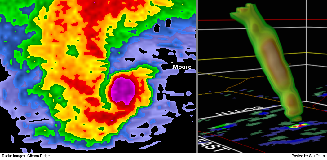
@StuOstro: Extreme hook echo, debris ball, & 3-D rotation of the #Moore #Oklahoma #tornado My thoughts r w/those affected  pic.twitter.com/mkswNlSGIL
0 likes
The above post and any post by Texas Snowman is NOT an official forecast and should not be used as such. It is just the opinion of the poster and may or may not be backed by sound meteorological data. It is NOT endorsed by any professional institution including storm2k.org. For official information, please refer to NWS products.
-
Texas Snowman
- Storm2k Moderator
- Posts: 6197
- Joined: Fri Jan 25, 2008 11:29 am
- Location: Denison, Texas
This is in my backyard (I live in the Red River Valley in Denison):
MESOSCALE DISCUSSION 0732
NWS STORM PREDICTION CENTER NORMAN OK
0534 PM CDT MON MAY 20 2013
AREAS AFFECTED...PORTIONS OF THE TX/OK RED RIVER VALLEY
CONCERNING...TORNADO WATCH 191...192...
VALID 202234Z - 202330Z
THE SEVERE WEATHER THREAT FOR TORNADO WATCH 191...192...CONTINUES.
SUMMARY...THE ENVIRONMENT FOR LONG-LIVED SUPERCELLS CAPABLE OF A
STRONG TORNADO OR TWO APPEAR TO BE MAXIMIZING NEAR THE RED RIVER
OVER THE NEXT 1-2 HRS.
DISCUSSION...22Z SURFACE ANALYSIS SHOWS PRESSURE FALLS MAXIMIZING
OVER N-CNTRL TX TO THE E OF THE DRYLINE AND TEMP/DEWPOINT SPREADS
ARE BEGINNING TO LOWER IN THE 10-15 DEG RANGE...SIGNIFYING HIGHER
BOUNDARY LAYER RH AND LOWER LCLS. ADDITIONALLY...SURFACE WINDS ARE
BEGINNING TO BACK SLIGHTLY FROM THE S TO SSE. ALTHOUGH THE 18Z FWD
RAOB SHOWED AN INVERSION LAYER AROUND H85...THE INFLUENCE OF THIS
FEATURE WILL PROBABLY BE LESSENED THROUGH FORCED STORM-SCALE ASCENT.
BECAUSE OF THE VERY UNSTABLE AIRMASS IN PLACE AND THE FORECAST
INCREASE IN H85 FLOW /INCREASING LOW LEVEL SHEAR/...THE TORNADO
THREAT APPEARS TO BE INCREASING. IF THE KFWS VWP OBSERVATIONS SHOW
A SIMILAR INCREASE IN LOW LEVEL SHEAR OVER THE NEXT HOUR OR SO AS
THE VARIOUS RAP FORECAST SOUNDINGS...A STRONG TORNADO OR TWO IS
POSSIBLE IN ADDITION TO LARGE HAIL AND DMGG WINDS.
..SMITH.. 05/20/2013
ATTN...WFO...FWD...OUN...
LAT...LON 33709772 33769817 33949815 34259714 34179674 33829699
33709772
0 likes
The above post and any post by Texas Snowman is NOT an official forecast and should not be used as such. It is just the opinion of the poster and may or may not be backed by sound meteorological data. It is NOT endorsed by any professional institution including storm2k.org. For official information, please refer to NWS products.
-
brunota2003
- S2K Supporter
- Posts: 9476
- Age: 35
- Joined: Sat Jul 30, 2005 9:56 pm
- Location: Stanton, KY...formerly Havelock, NC
- Contact:
Return to “USA & Caribbean Weather”
Who is online
Users browsing this forum: No registered users and 178 guests