For posterity's sake, thought I'd start a thread where information, video, pics, radar shots, etc. can be placed.
Kind of a "file" for future outbreaks, research, etc.
May 20, 2013 Moore Tornado - Information, Video, Radar, Pics
Moderator: S2k Moderators
Forum rules

The posts in this forum are NOT official forecast and should not be used as such. They are just the opinion of the poster and may or may not be backed by sound meteorological data. They are NOT endorsed by any professional institution or STORM2K.
-
Texas Snowman

- Storm2k Moderator

- Posts: 6197
- Joined: Fri Jan 25, 2008 11:29 am
- Location: Denison, Texas
May 20, 2013 Moore Tornado - Information, Video, Radar, Pics
0 likes
The above post and any post by Texas Snowman is NOT an official forecast and should not be used as such. It is just the opinion of the poster and may or may not be backed by sound meteorological data. It is NOT endorsed by any professional institution including storm2k.org. For official information, please refer to NWS products.
-
Texas Snowman
- Storm2k Moderator
- Posts: 6197
- Joined: Fri Jan 25, 2008 11:29 am
- Location: Denison, Texas
Tornado Timeline as per Norman NWS Twitter feed:
LEAD-UP TO TORNADO WARNING:
* 12:08 p.m. -- @NWSNorman : Just launched a weather balloon. Cap is still there, but not strong and very breakable. Strong shear in place. #okwx
* 12:30 p.m. -- @NWSNorman: A tornado watch will be issued soon for much of Oklahoma. Stay alert! #okwx
* 12:51 p.m. -- @NWSNorman: 12:50pm - first signs on storm development on radar southeast of Lawton. #okwx
* 1:20 p.m. -- @NWSNorman: Tornado watch: rapid intense storm development expected next few hours, both near stalled front west of I-35, and near the dry line SW OK.
* 1:23 p.m. -- @NWSNorman: Isolated supercells likely along dry line with storms initially capable of very large hail. Tornado threat increases thru afternoon.
* 1:34 p.m. -- @NWSNorman: 1:33pm - rapidly intensifying storm near Pumpkin Center - NW Stephens Co - already producing nickel sized hail. #okwx
* 1:58 p.m. - @NWSNorman: 1:56pm - dry line visible on radar from SW of Minco to Elgin to Walters. Cold front from Minco to Yukon to Perkins. Areas S and E stay alert.
* 2:09 p.m. -- @NWSNorman: 2:08pm storms developing near Blanchard and Tuttle, moving NE at 30 mph. Stay alert Norman, Moore, and S OKC. Not severe yet. #okwx
* 2:13 p.m. -- @NWSNorman: 2:11pm - severe thunderstorm warning for OKC metro area. Severe storm near Bridge Creek moving NE 40 mph.#okwx
* 2:24 p.m. -- @NWSNorman: 2:22pm - things are getting very busy! Every storm that forms goes severe quickly. Please stay alert and be ready to act quickly! #okwx
* 2:30 p.m. -- @NWSNorman: 2:30pm - people in south OKC, Moore and north Norman need to be pay VERY close attention to the storm near Newcastle!! #okwx
* 2:34 p.m. -- @NWSNorman: One warning forecaster focusing on big supercell west of OKC. #okwx pic.twitter.com/MVbwWhvigl
* 2:39 p.m. -- @NWSNorman: 2:39pm - storm west of Newcastle is intensifying and showing some rotation. Stay alert! No tornado warning yet. #okwx
-----
0 likes
The above post and any post by Texas Snowman is NOT an official forecast and should not be used as such. It is just the opinion of the poster and may or may not be backed by sound meteorological data. It is NOT endorsed by any professional institution including storm2k.org. For official information, please refer to NWS products.
-
Texas Snowman
- Storm2k Moderator
- Posts: 6197
- Joined: Fri Jan 25, 2008 11:29 am
- Location: Denison, Texas
Re: May 20, 2013 Moore Tornado - Information, Video, Radar, Pics
INITIAL TORNADO WARNING INFO:
* 2:41 p.m. -- @NWSNorman: 2:40pm - TORNADO WARNING for OKC metro! Developing tornado near Newcastle moving E 20 MPH. Take shelter!! #okwx
* 2:46 p.m. -- @NWSNorman: 2:45pm - you DO NOT want to be in your car in a tornado! Stay where you are. Get in, get down and cover up. Tornado may affect Moore/S OKC
* 2:52 p.m. -- @NWSNorman: DO NOT take cover under highway overpasses!!! You will prevent people from getting to shelter. Get OFF THE ROAD and find a store, restaurant
* 2:56 p.m. -- @NWSNorman: 2:55pm - TORNADO! ON the north side of Newcastle moving east! #okwx
* 2:57 p.m. -- @NWSNorman: Tornado north side of Newcastle at 2:56pm! pic.twitter.com/yryCp4WUW1
* 3:00 p.m. -- @NWSNorman: Large dangerous tornado at 3pm!!! pic.twitter.com/2hUzM0BV7k
* 3:01 p.m. -- @NWSNorman: 3:01pm - TORNADO EMERGENCY OKC METRO!!
* 3:03 p.m. -- @NWSNorman: 3:02pm - LARGE VIOLENT TORNADO moving toward Moore and SW OKC. Take cover right NOW!!! Do not wait!! #okwx
* 3:14 p.m. -- @NWSNorman: Large deadly tornado moving into Moore near 134th and Western. pic.twitter.com/YA2pzEegqG
* 3:19 p.m. -- @NWSNorman: 3:19pm - TORNADO Approaching area near Warren Theater in Moore! Please take shelter. This is as bad as it gets. #okwx
-----
Last edited by Texas Snowman on Mon May 20, 2013 10:24 pm, edited 1 time in total.
0 likes
The above post and any post by Texas Snowman is NOT an official forecast and should not be used as such. It is just the opinion of the poster and may or may not be backed by sound meteorological data. It is NOT endorsed by any professional institution including storm2k.org. For official information, please refer to NWS products.
-
Texas Snowman
- Storm2k Moderator
- Posts: 6197
- Joined: Fri Jan 25, 2008 11:29 am
- Location: Denison, Texas
MOORE TORNADO EMERGENCY:
* 3:21 p.m. -- @NWSNorman: TORNADO EMERGENCY for the City of Moore. Get as far inside a sturdy building as you can. Cover up! Do not wait! #okwx
* 3:22 p.m. -- @NWSNorman: 3:22pm - the tornado is so large you may not realize it's a tornado. If you are in Moore, go to shelter NOW! #okwx
* 3:26 p.m. -- @NWSNorman: 3:25pm - tornado crossed I-35 in south Moore and is now moving along and south of 4th street. Take cover! #okwx
* 3:29 p.m. -- @NWSNorman: TORNADO EMERGENCY for Moore. 3:28pm pic.twitter.com/OiS2qIUcmc
Last edited by Texas Snowman on Mon May 20, 2013 10:31 pm, edited 1 time in total.
0 likes
The above post and any post by Texas Snowman is NOT an official forecast and should not be used as such. It is just the opinion of the poster and may or may not be backed by sound meteorological data. It is NOT endorsed by any professional institution including storm2k.org. For official information, please refer to NWS products.
-
Texas Snowman
- Storm2k Moderator
- Posts: 6197
- Joined: Fri Jan 25, 2008 11:29 am
- Location: Denison, Texas
ROPE OUT STAGE:
* 3:34 p.m. -- @NWSNorman: 3:32pm - SE OKC is in immediate danger! Take cover. Large violent tornado moving your way. Do not wait to see the tornado! #okwx
* 3:35 p.m. -- @NWSNorman: 3:34pm - tornado moving toward lake Stanley Draper and will come VERY close to the KTLX radar site. #okwx
* 3:37 p.m. -- @NWSNorman: 3:36pm - tornado has roped out west of Lake Stanley Draper. #okwx
* 3:42 p.m. -- @NWSNorman: 3:40pm - Tornado could develop again at any time near Lake Stanley Draper! We are NOT in the clear yet! Stay alert! #okwx
-----
Last edited by Texas Snowman on Mon May 20, 2013 10:34 pm, edited 1 time in total.
0 likes
The above post and any post by Texas Snowman is NOT an official forecast and should not be used as such. It is just the opinion of the poster and may or may not be backed by sound meteorological data. It is NOT endorsed by any professional institution including storm2k.org. For official information, please refer to NWS products.
-
Texas Snowman
- Storm2k Moderator
- Posts: 6197
- Joined: Fri Jan 25, 2008 11:29 am
- Location: Denison, Texas
AFTERMATH:
* 4:02 p.m. -- @NWSNorman: PRELIMINARY tornado damage track for the Newcastle-Moore-South OKC tornado. Based on radar and damage reports. #okwx pic.twitter.com/MT0auFhmnY
* 4:14 p.m. -- @NWSNorman: Newcastle-Moore OKC Tornado was on the ground approx. 40 minutes. Tornado warning was in effect for 16 minutes before tornado developed.
* 4:24 p.m. -- @NWSNorman: Comparison between May 3 1999 and PRELIM May 20, 2013 tornado paths - #okwx pic.twitter.com/oDsgb4uZo4
* 4:58 p.m. -- @NWSNorman: 4:58pm - Preliminary Rating of Newcastle-Moore Tornado at least EF-4 #okwx
* 7:42 p.m. -- @NWSNorman: 7:42pm-HEADS UP: I-44 bridge over the Canadian River is closed both directions. Traffic is causing issues for First Responders, Please Avoid!
* 8:02 p.m. -- @NWSNorman: FB page for Moore Tornado Recovery Information: https://www.facebook.com/MooreOKTornado ... fc76f656b4 …
* 9:22 p.m. -- @NWSNorman: 9:21pm - Elevated non-svr storm moving over OKC Airport into south OKC, will not directly impact Newcastle-Moore #okwx (1of2)
* 9:23 p.m. -- @NWSNorman: 9:22pm - Lightning and gusty winds will be a concern however for first responders. Please Be Weather Aware! #okwx (2of2)
-----
0 likes
The above post and any post by Texas Snowman is NOT an official forecast and should not be used as such. It is just the opinion of the poster and may or may not be backed by sound meteorological data. It is NOT endorsed by any professional institution including storm2k.org. For official information, please refer to NWS products.
-
Texas Snowman
- Storm2k Moderator
- Posts: 6197
- Joined: Fri Jan 25, 2008 11:29 am
- Location: Denison, Texas
Re: May 20, 2013 Moore Tornado - Information, Video, Radar, Pics
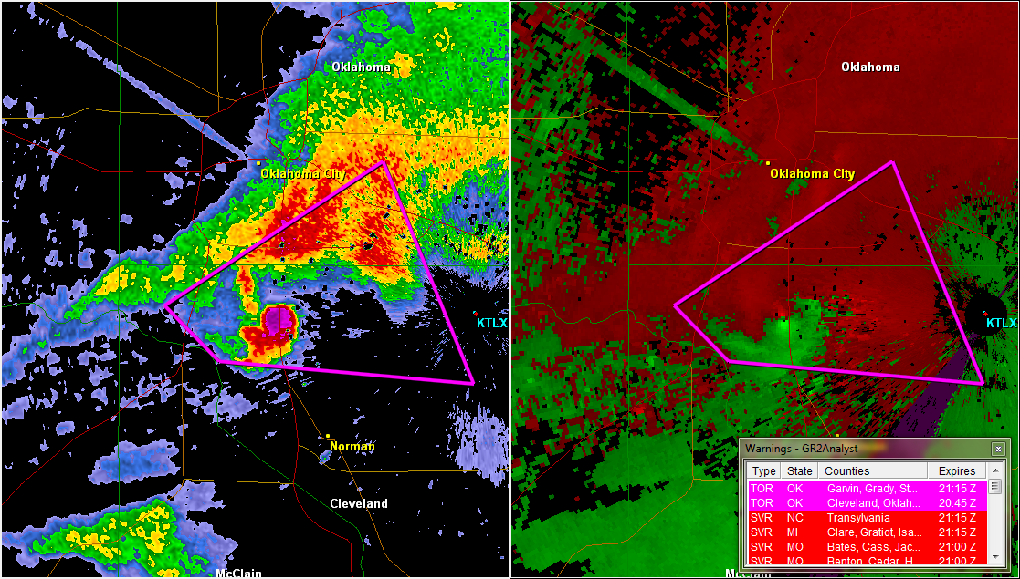
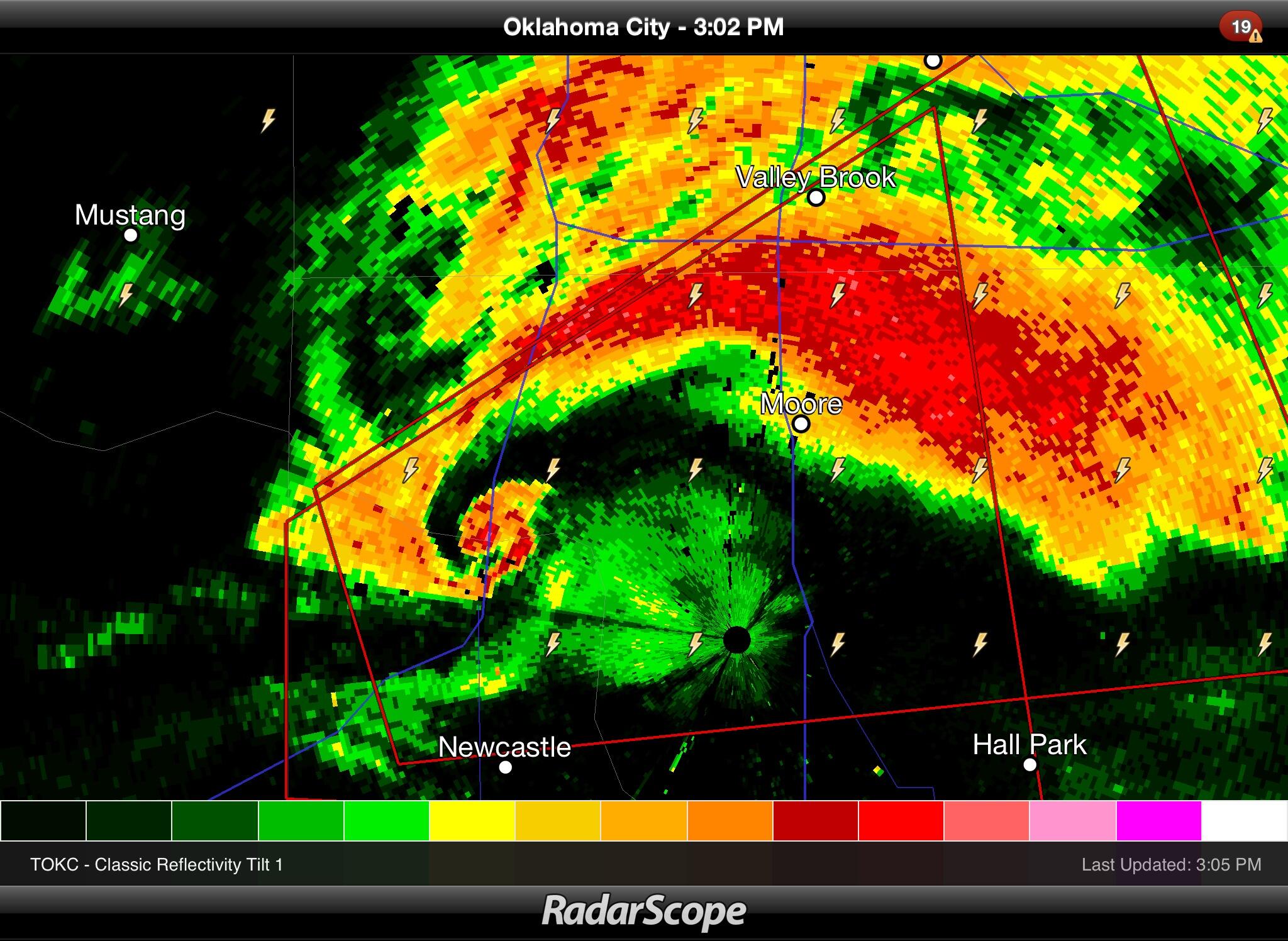
Radar Shot (US Tornadoes tweet) of HUGE debris ball in Moore, OK on 5/20/2013:
0 likes
The above post and any post by Texas Snowman is NOT an official forecast and should not be used as such. It is just the opinion of the poster and may or may not be backed by sound meteorological data. It is NOT endorsed by any professional institution including storm2k.org. For official information, please refer to NWS products.
-
Texas Snowman
- Storm2k Moderator
- Posts: 6197
- Joined: Fri Jan 25, 2008 11:29 am
- Location: Denison, Texas
Re: May 20, 2013 Moore Tornado - Information, Video, Radar, Pics
U.S. Tornadoes tweet:
@USTornadoes: "Cross section showing clear BWER on the tornado. Debris lofted thousands of feet in the air..."
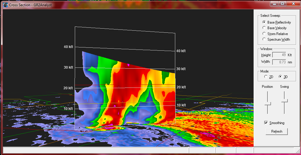
@USTornadoes: "Cross section showing clear BWER on the tornado. Debris lofted thousands of feet in the air..."
0 likes
The above post and any post by Texas Snowman is NOT an official forecast and should not be used as such. It is just the opinion of the poster and may or may not be backed by sound meteorological data. It is NOT endorsed by any professional institution including storm2k.org. For official information, please refer to NWS products.
-
Texas Snowman
- Storm2k Moderator
- Posts: 6197
- Joined: Fri Jan 25, 2008 11:29 am
- Location: Denison, Texas
Tweet from the legendary James Spann:
James Spann 8h
@span: "Debris ball on OKC terminal radar approaching Moore, OK #okwx pic.twitter.com/QEOEcvNlh7 "
James Spann 8h
@span: "Debris ball on OKC terminal radar approaching Moore, OK #okwx pic.twitter.com/QEOEcvNlh7 "
0 likes
The above post and any post by Texas Snowman is NOT an official forecast and should not be used as such. It is just the opinion of the poster and may or may not be backed by sound meteorological data. It is NOT endorsed by any professional institution including storm2k.org. For official information, please refer to NWS products.
-
brunota2003

- S2K Supporter

- Posts: 9476
- Age: 35
- Joined: Sat Jul 30, 2005 9:56 pm
- Location: Stanton, KY...formerly Havelock, NC
- Contact:
-
Texas Snowman
- Storm2k Moderator
- Posts: 6197
- Joined: Fri Jan 25, 2008 11:29 am
- Location: Denison, Texas
Time Lapse Video of Moore, OK Tornado 5/20/2013
http://www.wmctv.com/category/240217/video-landing-page?clipId=8899079&autostart=true
http://www.wmctv.com/category/240217/video-landing-page?clipId=8899079&autostart=true
0 likes
The above post and any post by Texas Snowman is NOT an official forecast and should not be used as such. It is just the opinion of the poster and may or may not be backed by sound meteorological data. It is NOT endorsed by any professional institution including storm2k.org. For official information, please refer to NWS products.
-
Texas Snowman
- Storm2k Moderator
- Posts: 6197
- Joined: Fri Jan 25, 2008 11:29 am
- Location: Denison, Texas
Re:
brunota2003 wrote:In the tweets, you can almost hear them going from cautious to desperate between the wx balloon and the tornado emergency.
Yeah, it's almost the Twitter version of the Joplin EMS responders and their radio chatter a couple of years ago.
0 likes
The above post and any post by Texas Snowman is NOT an official forecast and should not be used as such. It is just the opinion of the poster and may or may not be backed by sound meteorological data. It is NOT endorsed by any professional institution including storm2k.org. For official information, please refer to NWS products.
-
Texas Snowman
- Storm2k Moderator
- Posts: 6197
- Joined: Fri Jan 25, 2008 11:29 am
- Location: Denison, Texas
Some of the most amazing footage I've ever seen at ground level...shot on a smartphone.
[youtube]http://www.youtube.com/watch?v=DnniqzHHpM4&feature=player_detailpage[/youtube]
[youtube]http://www.youtube.com/watch?v=DnniqzHHpM4&feature=player_detailpage[/youtube]
0 likes
The above post and any post by Texas Snowman is NOT an official forecast and should not be used as such. It is just the opinion of the poster and may or may not be backed by sound meteorological data. It is NOT endorsed by any professional institution including storm2k.org. For official information, please refer to NWS products.
-
Texas Snowman
- Storm2k Moderator
- Posts: 6197
- Joined: Fri Jan 25, 2008 11:29 am
- Location: Denison, Texas
Tweet and very up close and personal photo of the Moore tornado from storm chaser Ben Holcomb (@wx8ben, benholcomb.com) as the tornado ripped through town. Check the link out:
@wx8ben: "Moore, OK tornado as it crosses Sooner Rd at SE 134th street #okwx pic.twitter.com/g8uQkbaTX6."
https://pbs.twimg.com/media/BKvSUglCEAAHH05.jpg:large
@wx8ben: "Moore, OK tornado as it crosses Sooner Rd at SE 134th street #okwx pic.twitter.com/g8uQkbaTX6."
https://pbs.twimg.com/media/BKvSUglCEAAHH05.jpg:large
Last edited by Texas Snowman on Tue May 21, 2013 1:07 am, edited 1 time in total.
0 likes
The above post and any post by Texas Snowman is NOT an official forecast and should not be used as such. It is just the opinion of the poster and may or may not be backed by sound meteorological data. It is NOT endorsed by any professional institution including storm2k.org. For official information, please refer to NWS products.
-
Texas Snowman
- Storm2k Moderator
- Posts: 6197
- Joined: Fri Jan 25, 2008 11:29 am
- Location: Denison, Texas
Unreal video from the guys at http://www.tornadotitans.com .
Warning - there is some LANGUAGE - and they note that on their FB page. But it's intense as debris starts falling out of the sky.
http://www.facebook.com/video/embed?video_id=556484097727626
Warning - there is some LANGUAGE - and they note that on their FB page. But it's intense as debris starts falling out of the sky.
http://www.facebook.com/video/embed?video_id=556484097727626
Last edited by Texas Snowman on Tue May 21, 2013 12:58 am, edited 1 time in total.
0 likes
The above post and any post by Texas Snowman is NOT an official forecast and should not be used as such. It is just the opinion of the poster and may or may not be backed by sound meteorological data. It is NOT endorsed by any professional institution including storm2k.org. For official information, please refer to NWS products.
-
Texas Snowman
- Storm2k Moderator
- Posts: 6197
- Joined: Fri Jan 25, 2008 11:29 am
- Location: Denison, Texas
Re: May 20, 2013 Moore Tornado - Information, Video, Radar, Pics
Historical info from May 20, 2013 - Moderate Risk for Central Oklahoma.
Map from a Tornado Titans Facebook post. (http://www.tornadotitans.com) Their early morning FB thoughts were almost prophetic:
"Round #3 today folks. Populated areas in Oklahoma up into SW MO and NW AR are under the gun for tornadoes today. Think the supercells that fire W and S of the OKC metro could pose a significant risk to lives and property again today. PLEASE keep a source of weather information handy and contact your neighbors to make sure they are in the loop. Be proactive and not reactive today!"
Last edited by Texas Snowman on Tue May 21, 2013 1:06 am, edited 3 times in total.
0 likes
The above post and any post by Texas Snowman is NOT an official forecast and should not be used as such. It is just the opinion of the poster and may or may not be backed by sound meteorological data. It is NOT endorsed by any professional institution including storm2k.org. For official information, please refer to NWS products.
-
Texas Snowman
- Storm2k Moderator
- Posts: 6197
- Joined: Fri Jan 25, 2008 11:29 am
- Location: Denison, Texas
Re: May 20, 2013 Moore Tornado - Information, Video, Radar, Pics
Historical info - from Tornado Titans' Facebook post earlier in the day (check the time stamp):
(http://www.tornadotitans.com)
"Winds backing out of the SE in this corridor in C. Oklahoma will maximize tornado potential this afternoon with any discrete cells."

(http://www.tornadotitans.com)
"Winds backing out of the SE in this corridor in C. Oklahoma will maximize tornado potential this afternoon with any discrete cells."
Last edited by Texas Snowman on Tue May 21, 2013 1:06 am, edited 1 time in total.
0 likes
The above post and any post by Texas Snowman is NOT an official forecast and should not be used as such. It is just the opinion of the poster and may or may not be backed by sound meteorological data. It is NOT endorsed by any professional institution including storm2k.org. For official information, please refer to NWS products.
-
Texas Snowman
- Storm2k Moderator
- Posts: 6197
- Joined: Fri Jan 25, 2008 11:29 am
- Location: Denison, Texas
Re: May 20, 2013 Moore Tornado - Information, Video, Radar, Pics
Another unreal video of the Moore tornado as it's tearing through neighborhoods. Not on YouTube yet, just on Facebook from a fellow named Jeff.
Can't believe how close this guy was.
http://www.facebook.com/video/embed?video_id=10200597107263068
Can't believe how close this guy was.
http://www.facebook.com/video/embed?video_id=10200597107263068
0 likes
The above post and any post by Texas Snowman is NOT an official forecast and should not be used as such. It is just the opinion of the poster and may or may not be backed by sound meteorological data. It is NOT endorsed by any professional institution including storm2k.org. For official information, please refer to NWS products.
-
Texas Snowman
- Storm2k Moderator
- Posts: 6197
- Joined: Fri Jan 25, 2008 11:29 am
- Location: Denison, Texas
Absolutely unreal footage as these guys covered the tornado.
"It's grinding...80 mph inflow...it's sucking us in...folks, there isn't time to delay or think, you've got to act now...move quickly, you may have seconds to take life saving action..."
IT IS INTENSE STUFF. Can't imagine how these guys keep their cool and do their job. Even as the tornado is threatening their own homes and families.
[youtube]http://www.youtube.com/watch?v=sEqXpesgYg0&feature=player_detailpage[/youtube]
Last edited by Texas Snowman on Tue May 21, 2013 1:57 am, edited 1 time in total.
0 likes
The above post and any post by Texas Snowman is NOT an official forecast and should not be used as such. It is just the opinion of the poster and may or may not be backed by sound meteorological data. It is NOT endorsed by any professional institution including storm2k.org. For official information, please refer to NWS products.
-
Texas Snowman
- Storm2k Moderator
- Posts: 6197
- Joined: Fri Jan 25, 2008 11:29 am
- Location: Denison, Texas
@AaronTuttleOK: "Our TDWR estimated 270mph winds (EF-5 tornado) when it was 3 mi WSW of Moore. #okwx pic.twitter.com/oiexWkLKw9 "

0 likes
The above post and any post by Texas Snowman is NOT an official forecast and should not be used as such. It is just the opinion of the poster and may or may not be backed by sound meteorological data. It is NOT endorsed by any professional institution including storm2k.org. For official information, please refer to NWS products.
Return to “USA & Caribbean Weather”
Who is online
Users browsing this forum: CaptinCrunch and 97 guests