Multi-day outbreak of May 25-31

U.S. & Caribbean Weather Discussions and Severe Weather Events

Moderator: S2k Moderators

Forum rules

The posts in this forum are NOT official forecast and should not be used as such. They are just the opinion of the poster and may or may not be backed by sound meteorological data. They are NOT endorsed by any professional institution or STORM2K.

Help Support Storm2K
Message
Author
User avatar
TropicalAnalystwx13
Category 5
Category 5
Posts: 2109
Age: 27
Joined: Tue Jul 19, 2011 8:20 pm
Location: Wilmington, NC
Contact:

Multi-day outbreak of May 25-31

#1 Postby TropicalAnalystwx13 » Sat May 25, 2013 7:34 pm

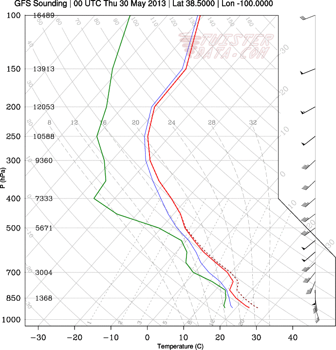
Here we go again. This jet stream disturbance is a lot more negatively tilted and nearly double the intensity of the previous one. Moisture comes straight from the Caribbean, and instability is expected to be very high once again. Not often we get a 100 knot mid-level jet in late May.

Image
Image
Last edited by cycloneye on Sun Jun 02, 2013 9:40 am, edited 2 times in total.
Reason: To modify the title
0 likes   

User avatar
Hurricaneman
Category 5
Category 5
Posts: 7351
Age: 45
Joined: Tue Aug 31, 2004 3:24 pm
Location: central florida

Re: Multi-day outbreak starting Tuesday

#2 Postby Hurricaneman » Sat May 25, 2013 7:38 pm

This could be really bad, the parameters are setting up for a major outbreak especially with the 100kt+ low level jet
0 likes   

RL3AO
Moderator-Pro Met
Moderator-Pro Met
Posts: 16308
Joined: Thu Jun 14, 2007 10:03 pm
Location: NC

#3 Postby RL3AO » Sat May 25, 2013 7:50 pm

Tuesday I'm not very impressed with. Wednesday is a bit better. This is for Western Kansas.

Image

It looks like an okay set up, but I'm not seeing "major outbreak". It has the upper level parameters, but it almost seems like the low level set-up (surface low, instability, and low LCL's) isn't quite there.
0 likes   

EF-5bigj
Category 3
Category 3
Posts: 864
Joined: Tue Feb 07, 2012 10:36 pm
Location: Spartanburg,SC

#4 Postby EF-5bigj » Sat May 25, 2013 8:01 pm

Again?
0 likes   

WeatherGuesser
Category 5
Category 5
Posts: 2672
Joined: Tue Jun 29, 2010 6:46 am

#5 Postby WeatherGuesser » Sat May 25, 2013 9:07 pm

I'll wait for the SPC. So far, they're showing "No Area".
0 likes   

User avatar
TropicalAnalystwx13
Category 5
Category 5
Posts: 2109
Age: 27
Joined: Tue Jul 19, 2011 8:20 pm
Location: Wilmington, NC
Contact:

#6 Postby TropicalAnalystwx13 » Sat May 25, 2013 9:24 pm

DAY 4-8 CONVECTIVE OUTLOOK
NWS STORM PREDICTION CENTER NORMAN OK
0352 AM CDT SAT MAY 25 2013

VALID 281200Z - 021200Z

...DISCUSSION...
THE GFS/ECMWF ARE IN GENERAL AGREEMENT ON TUESDAY /DAY 4/ IN SHOWING
STRONG SWLY FLOW OVER THE SRN HIGH PLAINS NEWD INTO THE
MIDWEST...SUPPORTING AT LEAST ISOLD SEVERE WITHIN THIS CORRIDOR
AHEAD OF THE AMPLIFYING WRN U.S. UPPER TROUGH. MODELS DIVERGE
SUBSTANTIALLY BY WEDNESDAY /DAY 5/ IN THE EVOLUTION OF THE WRN U.S.
UPPER TROUGH AS IT MOVES INTO THE CNTRL U.S. THE 00Z/25 GFS SHOWS A
LESS AMPLIFIED SOLUTION VS. THE 00Z/25 ECMWF EXHIBITING A MORE
MERIDIONAL/HIGHER AMPLITUDE SCENARIO AS A NEGATIVELY-TILTED TROUGH
EJECTS INTO THE CNTRL STATES. ALTHOUGH IT SEEMS PROBABLE AN
ELONGATED MID LEVEL LOW WILL BECOME CENTERED OVER THE NWRN CONUS BY
MID-LATE WEEK...CONSIDERABLE SPREAD IS NOTED IN THE ECMWF/GEFS
ENSEMBLE MEMBERS IN THE EVOLUTION OF EJECTING SHORTWAVE FEATURES.
AS A RESULT...CONSIDERABLE UNCERTAINTY EXISTS FROM WEDNESDAY /DAY 5/
INTO NEXT WEEKEND AND PRECLUDES THE HIGHLIGHT OF POSSIBLE 30 PERCENT
SEVERE PROBABILITY AREAS AT THIS TIME. DESPITE THE AFOREMENTIONED
MODEL PREDICTABILITY CONCERNS AND PRIOR DAY/S STORM ACTIVITY
EXERTING INFLUENCE ON SUBSEQUENT DAY/S...A POTENTIALLY ACTIVE
SEVERAL DAY PERIOD FOR SEVERE WEATHER IS POSSIBLE. THEREFORE...AN
INCREASED RISK FOR ORGANIZED SEVERE STORMS SEEMS PLAUSIBLE FOR PARTS
OF THE PLAINS AND MIDWEST ON TUESDAY /DAY 4/...OVER A LARGER PORTION
OF THE PLAINS ON WEDNESDAY /DAY 5/ AND THEN POSSIBLY IN PARTS OF THE
PLAINS AND UPPER MIDWEST ON THURSDAY /DAY 6/.


..SMITH.. 05/25/2013
0 likes   

User avatar
Ntxw
Storm2k Moderator
Storm2k Moderator
Posts: 22783
Joined: Wed Oct 21, 2009 6:34 pm
Location: DFW, Texas

#7 Postby Ntxw » Sat May 25, 2013 11:21 pm

The troughing shown by the GFS and Euro certainly is not very common this late in May. While it's too far out to beat the drums on a major outbreak, with that kind of wind streak over such a large area, it's the right pattern for a large scale negative tilted trough to effect a bigger region as more typical with classic outbreaks that sometimes involve high risks.
0 likes   
The above post and any post by Ntxw is NOT an official forecast and should not be used as such. It is just the opinion of the poster and may or may not be backed by sound meteorological data. It is NOT endorsed by any professional institution including Storm2k. For official information, please refer to NWS products.

  Help support Storm2K!
Help Support Storm2K

User avatar
TwisterFanatic
Category 5
Category 5
Posts: 1041
Joined: Mon Jun 28, 2010 12:43 pm
Location: Sallisaw, Oklahoma

Re:

#8 Postby TwisterFanatic » Sat May 25, 2013 11:50 pm

WeatherGuesser wrote:I'll wait for the SPC. So far, they're showing "No Area".


Because of the divergence between the EURO and GFS.
0 likes   
Personal Forecast Disclaimer:
The posts in this forum are NOT official forecast and should not be used as such. They are just the opinion of the poster and may or may not be backed by sound meteorological data. They are NOT endorsed by any professional institution or storm2k.org. For official information, please refer to the NHC and NWS products.

User avatar
TropicalAnalystwx13
Category 5
Category 5
Posts: 2109
Age: 27
Joined: Tue Jul 19, 2011 8:20 pm
Location: Wilmington, NC
Contact:

#9 Postby TropicalAnalystwx13 » Sun May 26, 2013 11:30 pm

The severe weather event may actually begin a little earlier, tomorrow, across central and eastern Nebraska and north-central/northeastern Kansas. In this region, the NAM and GFS forecast CAPE on the order of 3-4k j/kg, dewpoints in the 70s, and very steep lapse rates. In addition, crossovers are good and bulk shear (Sfc-500mb) is AOA 60 knots. A cap is likely to hold until late afternoon, at which time we may see isolated supercells develop. LCL heights are expected to be 750-1250 m; okay but not "ideal" per se. Would not be surprised to see an upgrade to Moderate risk.
0 likes   

WeatherGuesser
Category 5
Category 5
Posts: 2672
Joined: Tue Jun 29, 2010 6:46 am

#10 Postby WeatherGuesser » Mon May 27, 2013 9:28 am

Very small Moderate for today. Still Slights for Tuesday and Wednesday.
0 likes   

apocalypt-flyer
Category 1
Category 1
Posts: 468
Joined: Sat Aug 27, 2005 11:51 am

Re: Multi-day outbreak starting Tuesday

#11 Postby apocalypt-flyer » Mon May 27, 2013 10:13 am

Not the most populated area in the MDT today which is good news.

Looks as though things will remain relatively active all week long with the main risk areas being Kansas/Oklahoma later this week.
0 likes   

User avatar
TwisterFanatic
Category 5
Category 5
Posts: 1041
Joined: Mon Jun 28, 2010 12:43 pm
Location: Sallisaw, Oklahoma

#12 Postby TwisterFanatic » Mon May 27, 2013 2:43 pm

1st Tornado reported in..... NW Wyoming.
0 likes   
Personal Forecast Disclaimer:
The posts in this forum are NOT official forecast and should not be used as such. They are just the opinion of the poster and may or may not be backed by sound meteorological data. They are NOT endorsed by any professional institution or storm2k.org. For official information, please refer to the NHC and NWS products.

User avatar
TwisterFanatic
Category 5
Category 5
Posts: 1041
Joined: Mon Jun 28, 2010 12:43 pm
Location: Sallisaw, Oklahoma

#13 Postby TwisterFanatic » Mon May 27, 2013 5:34 pm

Tornado Warning should be issued soon for the storm in Northern Kansas on the southern end of that cluster. IMO
0 likes   
Personal Forecast Disclaimer:
The posts in this forum are NOT official forecast and should not be used as such. They are just the opinion of the poster and may or may not be backed by sound meteorological data. They are NOT endorsed by any professional institution or storm2k.org. For official information, please refer to the NHC and NWS products.

User avatar
Cyclenall
Category 5
Category 5
Posts: 6666
Joined: Thu Jun 08, 2006 10:01 pm
Location: Ontario, Canada

Could history be made this week?

#14 Postby Cyclenall » Mon May 27, 2013 6:32 pm

This period coming up could be extremely active and the most significant time this year for tornadoes. Because of the crazy Pacific jet anomaly the models are in agreement with, and the Gulf being wide open for the time being, the potential for a major tornado outbreak sequence exists. This is especially true if a series of low-pressure areas eject continuously. What really blows me away is the analogs this period is being compared to by both weather professionals and models. I've seen references to the June 1990 Lower Ohio Valley tornado outbreak (one of the worst for June in that region), the May–June 1917 tornado outbreak sequence (the worst and longest major tornado outbreak sequence on record...lasting 8 days, killing 383, with 15 violent tornadoes :eek: :eek: ), and the late May 2004 period (May 30th had the largest High Risk day ever issued by the SPC). A good quote that sums this up is "the tornado season is a month behind this year so its like were entering early May right now." As TropicalAnalystwx13 already stated, there could be a violent tornado later tonight in northern KS to kick this week off if a supercell and get in the right spot. I'll be glued again to the computer all week it appears.

apocalypt-flyer wrote:Looks as though things will remain extremely active all week long with the main risk areas being Kansas/Oklahoma later this week.

Fixed.

TwisterFanatic wrote:1st Tornado reported in..... NW Wyoming.

Seems like Wyoming lately likes to be the first to get something during these MOD risks, weird.

TwisterFanatic wrote:Tornado Warning should be issued soon for the storm in Northern Kansas on the southern end of that cluster. IMO

Agreed, a ton of severe thunderstorm warnings clustered around it right now but I'm amazed at how fast it went from zero echoes to 60+ dbz...very explosive. It also looks strange:

Image
0 likes   

User avatar
Cyclenall
Category 5
Category 5
Posts: 6666
Joined: Thu Jun 08, 2006 10:01 pm
Location: Ontario, Canada

#15 Postby Cyclenall » Mon May 27, 2013 6:50 pm

The storm I was just talking about (most likely a supercell) already produced a tornado, the first today in KS I believe:

2329 4 NW SMITH CENTER SMITH KS 3982 9884 WEAK TORNADO WITH BRIEF TOUCHDOWN REPORTED APPROXIMATELY 3-4 MILES NORTHWEST OF SMITH CENTER. LASTED FOR LESS THAN ONE MINUTE. (GID)

It looks beasty with a hook. New cells are starting to fire up to the south of that too...I don't know if that was even expected because the high-res short-term models were only showing 1 huge sup later tonight to my knowledge.
0 likes   

User avatar
TwisterFanatic
Category 5
Category 5
Posts: 1041
Joined: Mon Jun 28, 2010 12:43 pm
Location: Sallisaw, Oklahoma

#16 Postby TwisterFanatic » Mon May 27, 2013 7:16 pm

Storm has an extremely impressive couplet right now.
0 likes   
Personal Forecast Disclaimer:
The posts in this forum are NOT official forecast and should not be used as such. They are just the opinion of the poster and may or may not be backed by sound meteorological data. They are NOT endorsed by any professional institution or storm2k.org. For official information, please refer to the NHC and NWS products.

User avatar
TropicalAnalystwx13
Category 5
Category 5
Posts: 2109
Age: 27
Joined: Tue Jul 19, 2011 8:20 pm
Location: Wilmington, NC
Contact:

#17 Postby TropicalAnalystwx13 » Mon May 27, 2013 8:25 pm

I've tracked a lot of violent tornadoes on radar...Greensburg, Parkersburg, St. Louis, Tuscaloosa and all the extreme couplets on April 27, 2011, Joplin, Hinton-Guthrie, Hattiesburg, Moore...but I have to say, this is the most intense and impressive radar signature I've ever seen. Gate-to-gate wind shear peaked out at 207.9 knots.

Tim Samarus, Reed Timmer, Sean Casey (and his crew), and others got dangerously close to what they reported as a half mile to mile-wide wedge. Apparently it swung the doors of the TIV2 open...that takes a very, very, very strong tornado.

Image
0 likes   

User avatar
TwisterFanatic
Category 5
Category 5
Posts: 1041
Joined: Mon Jun 28, 2010 12:43 pm
Location: Sallisaw, Oklahoma

#18 Postby TwisterFanatic » Mon May 27, 2013 8:49 pm

As fast as it ramped up, it fell apart just as quick.
0 likes   
Personal Forecast Disclaimer:
The posts in this forum are NOT official forecast and should not be used as such. They are just the opinion of the poster and may or may not be backed by sound meteorological data. They are NOT endorsed by any professional institution or storm2k.org. For official information, please refer to the NHC and NWS products.

User avatar
Cyclenall
Category 5
Category 5
Posts: 6666
Joined: Thu Jun 08, 2006 10:01 pm
Location: Ontario, Canada

Re: Multi-day outbreak for most of this week

#19 Postby Cyclenall » Mon May 27, 2013 10:01 pm

SEVERE WEATHER STATEMENT
NATIONAL WEATHER SERVICE TOPEKA KS
948 PM CDT MON MAY 27 2013

KSC117-280300-
/O.CON.KTOP.TO.W.0007.000000T0000Z-130528T0300Z/
MARSHALL-
948 PM CDT MON MAY 27 2013

...A TORNADO WARNING REMAINS IN EFFECT FOR NORTHERN MARSHALL COUNTY
UNTIL 1000 PM CDT...

AT 945 PM CDT...A CONFIRMED LARGE AND EXTREMELY DANGEROUS TORNADO WAS
LOCATED NEAR MARYSVILLE...AND MOVING EAST AT 40 MPH.


THIS IS A PARTICULARLY DANGEROUS SITUATION.


HAZARD...DAMAGING TORNADO.

SOURCE...EMERGENCY MANAGEMENT CONFIRMED TORNADO 1 MILE NORTHWEST OF
MARYSVILLE AT 945 PM...MOVING EAST.

IMPACT...YOU ARE IN A LIFE THREATENING SITUATION. MOBILE HOMES WILL
BE DESTROYED. CONSIDERABLE DAMAGE TO HOMES...BUSINESSES AND
VEHICLES IS LIKELY AND COMPLETE DESTRUCTION POSSIBLE. FLYING
DEBRIS WILL BE DEADLY TO PEOPLE AND ANIMALS. EXPECT TREES TO
BE UPROOTED OR SNAPPED.


THE TORNADO WILL BE NEAR...
BEATTIE AROUND 1000 PM CDT.

PRECAUTIONARY/PREPAREDNESS ACTIONS...

HEAVY RAINFALL MAY HIDE THIS TORNADO. DO NOT WAIT TO SEE OR HEAR THE
TORNADO. TAKE COVER NOW.

&&

LAT...LON 3994 9671 4000 9636 3982 9633 3978 9667
TIME...MOT...LOC 0248Z 259DEG 35KT 3986 9660

TORNADO...OBSERVED
TORNADO DAMAGE THREAT...CONSIDERABLE
HAIL...1.75IN

$$
--------------------------------------------------------------------------------


On radar it just looks like a ball of heavy rains :eek: :eek: . This is very bad, very heavily rain-wrapped or prone to it at least like eariler storms.
0 likes   

User avatar
Cyclenall
Category 5
Category 5
Posts: 6666
Joined: Thu Jun 08, 2006 10:01 pm
Location: Ontario, Canada

They Did It!!!!!

#20 Postby Cyclenall » Mon May 27, 2013 11:59 pm

TropicalAnalystwx13 wrote:I've tracked a lot of violent tornadoes on radar...Greensburg, Parkersburg, St. Louis, Tuscaloosa and all the extreme couplets on April 27, 2011, Joplin, Hinton-Guthrie, Hattiesburg, Moore...but I have to say, this is the most intense and impressive radar signature I've ever seen. Gate-to-gate wind shear peaked out at 207.9 knots.

Tim Samarus, Reed Timmer, Sean Casey (and his crew), and others got dangerously close to what they reported as a half mile to mile-wide wedge. Apparently it swung the doors of the TIV2 open...that takes a very, very, very strong tornado.

Image

Folks, history was made on Monday with the first ever IMAX footage captured inside what is believed to be a violent tornado!!!!!! :D :D :D :woo: :woo: This is remarkable, I wondered for years when they'd finally get it and now they have without any lives lost or injuries to the team! Well done TIV crew, people are behind you guys from all over the world. Based on Sean's tweets, it sounded insane with the most dramatic event of their lives taking place during the intercept. They just happened to get in the thick of it at the right time in this very brief tornado so a major feat was accomplished.

Hearing about the door opening and mud and debris all over the thing, its amazing no one died because a piece of wood also got in the TIV...that could have easily killed someone or all in there making it the first deaths of storm chasers on record. They got stuck in mud for hours and the weather instruments on top got ripped off. I knew it was just a matter of time before a weak tornado that they attempted to get into would rapidly strengthen to a EF4/5 and before they could get out, and strike it. Strangely the TIV itself did not move so I wonder what was going on there. Sean said they got 2 minutes and 30 seconds of footage in IMAX, they haven't viewed it yet so cross your fingers for something never seen before in tornado filmography.

TropicalAnalystwx13, what is that image showing of the tornado on the bottom right of that grid? Doesn't look familiar.

[youtube]http://www.youtube.com/watch?v=LobCDYO78Us[/youtube]

Link: https://twitter.com/SeanCaseyImax
0 likes   


Return to “USA & Caribbean Weather”

Who is online

Users browsing this forum: wxman22 and 13 guests