Multi-day outbreak of May 25-31
Moderator: S2k Moderators
Forum rules

The posts in this forum are NOT official forecast and should not be used as such. They are just the opinion of the poster and may or may not be backed by sound meteorological data. They are NOT endorsed by any professional institution or STORM2K.
-
TwisterFanatic

- Category 5

- Posts: 1041
- Joined: Mon Jun 28, 2010 12:43 pm
- Location: Sallisaw, Oklahoma
Weird. Dr. Forbes has a 7/10 on his TorCon scale for Wednesday, Tornado is not even mentioned once his the SPC Day 2 outlook, unless I missed it.
0 likes
Personal Forecast Disclaimer:
The posts in this forum are NOT official forecast and should not be used as such. They are just the opinion of the poster and may or may not be backed by sound meteorological data. They are NOT endorsed by any professional institution or storm2k.org. For official information, please refer to the NHC and NWS products.
The posts in this forum are NOT official forecast and should not be used as such. They are just the opinion of the poster and may or may not be backed by sound meteorological data. They are NOT endorsed by any professional institution or storm2k.org. For official information, please refer to the NHC and NWS products.

Re:
TwisterFanatic wrote:Weird. Dr. Forbes has a 7/10 on his TorCon scale for Wednesday, Tornado is not even mentioned once his the SPC Day 2 outlook, unless I missed it.
I heard about that too, one of the biggest discrepancies I've seen.
EDIT: I just got around to watching that YT video of the TIV2 being hit by the wedge tornado (computer issues on my end prevented me from seeing it right away), and I can honestly say I've never seen anything like that in my friggen life!!!!!!!!!!!
0 likes
-
wx247

- S2K Supporter

- Posts: 14279
- Age: 42
- Joined: Wed Feb 05, 2003 10:35 pm
- Location: Monett, Missouri
- Contact:
They came very close to being in a very, very life threatening situation. I read where one of the doors was blown open by the tornado. Debris was blown into the TIV. While it is great to capture such amazing footage, I don't think you would want to do so at the price of (at a minimum) a limb.
Today's severe weather threat appears quite sloppy... there will be some locally very intense storms, but there appears to be no real focus for organization. Localized boundaries will probably play a larger role than any large scale mechanisms today. Looks much more organized as we head into the Thursday/Friday time frame, although we have a couple of days for that to change.
Today's severe weather threat appears quite sloppy... there will be some locally very intense storms, but there appears to be no real focus for organization. Localized boundaries will probably play a larger role than any large scale mechanisms today. Looks much more organized as we head into the Thursday/Friday time frame, although we have a couple of days for that to change.
0 likes
Personal Forecast Disclaimer:
The posts in this forum are NOT official forecast and should not be used as such. They are just the opinion of the poster and may or may not be backed by sound meteorological data. They are NOT endorsed by any professional institution or storm2k.org. For official information, please refer to the NHC and NWS products.
The posts in this forum are NOT official forecast and should not be used as such. They are just the opinion of the poster and may or may not be backed by sound meteorological data. They are NOT endorsed by any professional institution or storm2k.org. For official information, please refer to the NHC and NWS products.

-
TwisterFanatic
- Category 5
- Posts: 1041
- Joined: Mon Jun 28, 2010 12:43 pm
- Location: Sallisaw, Oklahoma
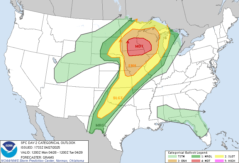
Ok, the SPC is coming in line now with Forbes on tomorrow. They've upgraded to Moderate and mention possibly strong Tornadoes across Western OK and Central Kansas.
0 likes
Personal Forecast Disclaimer:
The posts in this forum are NOT official forecast and should not be used as such. They are just the opinion of the poster and may or may not be backed by sound meteorological data. They are NOT endorsed by any professional institution or storm2k.org. For official information, please refer to the NHC and NWS products.
The posts in this forum are NOT official forecast and should not be used as such. They are just the opinion of the poster and may or may not be backed by sound meteorological data. They are NOT endorsed by any professional institution or storm2k.org. For official information, please refer to the NHC and NWS products.
-
WeatherGuesser
- Category 5
- Posts: 2672
- Joined: Tue Jun 29, 2010 6:46 am
Fairly large Moderate for Wednesday: (link to map graphic: http://www.spc.noaa.gov/products/outloo ... 30_prt.gif )
DAY 2 CONVECTIVE OUTLOOK
NWS STORM PREDICTION CENTER NORMAN OK
1219 PM CDT TUE MAY 28 2013
VALID 291200Z - 301200Z
...THERE IS A MDT RISK OF SVR TSTMS ACROSS WRN OK...MUCH OF CNTRL KS
INTO SCNTRL NEB...
...THERE IS A SLGT RISK OF SVR TSTMS SURROUNDING THE MDT RISK FROM
SWRN TX INTO SD/SRN MN...
...THERE IS A SLGT RISK OF SVR TSTMS ACROSS PARTS OF THE
NORTHEASTERN U.S....
...CENTRAL AND SOUTHERN PLAINS...
LATEST WV IMAGERY SUGGESTS SECONDARY UPSTREAM CORRIDOR OF STRONGER
FLOW IS DIGGING SEWD ALONG THE NV/CA BORDER TOWARD AZ. WHILE THERE
ARE DISCREPANCIES AMONG THE LATEST MODELS REGARDING THE EVOLUTION OF
THIS FLOW...IT APPEARS STRENGTHENING AT MID LEVELS MAY OCCUR OVER
THE SRN HIGH PLAINS DURING THE DAY WEDNESDAY. 12Z GFS IS THE MOST
AGGRESSIVE INTENSIFYING FLOW AT 500MB OVER THE ERN TX PANHANDLE BY
LATE MORNING WITH 50-60KT EXPECTED TO SPREAD ACROSS THE DRYLINE INTO
WRN OK/CNTRL KS BY 21Z. WHILE THE NAM IS SOMEWHAT WEAKER WITH MID
LEVEL FLOW...TIMING OF UPPER TROUGH INTO THE HIGH
PLAINS...COINCIDENT WITH DIURNAL HEATING CYCLE...IS ON PAR WITH GFS.
FOR THIS REASON HAVE INCREASED SEVERE PROBABILITIES ALONG/EAST OF
THE DRYLINE TO ACCOUNT FOR A POTENTIALLY MORE SIGNIFICANT SEVERE
EVENT. LARGE HAIL...DAMAGING WINDS...AND TORNADOES...POSSIBLY
STRONG...MAY ACCOMPANY SUPERCELLS THAT DEVELOP DURING THE DAY2
PERIOD ACROSS THE PLAINS.
IT/S NOT ENTIRELY CLEAR HOW CONVECTION WILL ULTIMATELY EVOLVE ACROSS
THE WARM SECTOR GIVEN THE STRENGTHENING SPEED MAX ACROSS THE
SRN/CNTRL PLAINS. INHIBITION AND SIGNIFICANT BOUNDARY LAYER
CLOUDINESS WILL LIKELY LIMIT HEATING ALONG A BROAD SWATH OF THE I-35
CORRIDOR...POSSIBLY SUPPRESSING DEEP CONVECTION THROUGH MID
AFTERNOON DESPITE APPROACHING SPEED MAX. HOWEVER...STRONG HEATING
WILL OCCUR ACROSS THE HIGH PLAINS AND CONFIDENCE IS RELATIVELY HIGH
DRYLINE CONVECTION WILL DEVELOP FROM SWRN KS...ARCING ACROSS THE ERN
TX PANHANDLE INTO NWRN TX. THESE STORMS WILL EVOLVE WITHIN AN
INCREASINGLY SHEARED AIRMASS SUPPORTIVE OF SUPERCELLS. ONCE THIS
ACTIVITY MATURES...ENVIRONMENTAL CONDITIONS FAVOR ENEWD MOVEMENT
ACROSS KS/OK BENEATH EJECTING SPEED MAX. ADDITIONALLY...LLJ IS
FORECAST TO INCREASE MARKEDLY BY LATE AFTERNOON WITH 50-70KT CORE
FOCUSING FROM NRN OK INTO SERN NEB.
AN UPWARD EVOLVING CLUSTER OF SEVERE STORMS IS POSSIBLE ACROSS THE
CNTRL PLAINS INTO IA DURING THE LATTER HALF OF THE PERIOD AS LLJ
SHIFTS INTO THE MID MS VALLEY AFTER MIDNIGHT.
FARTHER NORTH...BROAD DIFFLUENT FLOW ALOFT SHOULD ALSO SUPPORT
ORGANIZED DEEP CONVECTION FROM SD INTO SRN MN...ALONG/SOUTH OF WARM
FRONT.
...NORTHEASTERN U.S...
BOTH THE NAM AND GFS SUGGEST A MID LEVEL SHORT-WAVE TROUGH/SPEED MAX
WILL EJECT ACROSS SRN ONTARIO INTO UPSTATE NY BY 18Z. WHILE WEAK
HEIGHT FALLS ARE EXPECTED TO REMAIN FOCUSED NORTH OF THE
U.S./CANADIAN BORDER...MODEST WLY FLOW WILL STRENGTHEN ACROSS NY
SUCH THAT DEEP LAYER SHEAR WILL BE THAN SUPPORTIVE OF ORGANIZED
TSTMS. IN THE ABSENCE OF SIGNIFICANT INHIBITION SCT TSTMS SHOULD
EASILY DEVELOP ALONG SRN INFLUENCE OF AFOREMENTIONED SHORT-WAVE
WITHIN AN ENVIRONMENT FAVORABLE FOR AT LEAST ORGANIZED MULTI-CELLS
AND LINE SEGMENTS. DEEP LAYER BULK SHEAR WOULD ALSO SUGGEST WEAK
ROTATION IS POSSIBLE...THOUGH DAMAGING WINDS SHOULD BE THE PRIMARY
THREAT WITH THESE DIURNALLY ENHANCED CLUSTERS.
..DARROW.. 05/28/2013
0 likes
-
apocalypt-flyer
- Category 1

- Posts: 468
- Joined: Sat Aug 27, 2005 11:51 am
Re: Multi-day outbreak for most of this week
That is a fairly large MDT for a day 2 warning, stretching all the way from Southern Nebraska to the OK/TEX boarder. Could be a busy day.
0 likes

-
TwisterFanatic
- Category 5
- Posts: 1041
- Joined: Mon Jun 28, 2010 12:43 pm
- Location: Sallisaw, Oklahoma
Large Tornado heading right towards Corning, KS. Debris ball on radar.
0 likes
Personal Forecast Disclaimer:
The posts in this forum are NOT official forecast and should not be used as such. They are just the opinion of the poster and may or may not be backed by sound meteorological data. They are NOT endorsed by any professional institution or storm2k.org. For official information, please refer to the NHC and NWS products.
The posts in this forum are NOT official forecast and should not be used as such. They are just the opinion of the poster and may or may not be backed by sound meteorological data. They are NOT endorsed by any professional institution or storm2k.org. For official information, please refer to the NHC and NWS products.
-
TwisterFanatic
- Category 5
- Posts: 1041
- Joined: Mon Jun 28, 2010 12:43 pm
- Location: Sallisaw, Oklahoma
Tornadoes reported in OK, KS and NEB in the last 15 minutes.
0 likes
Personal Forecast Disclaimer:
The posts in this forum are NOT official forecast and should not be used as such. They are just the opinion of the poster and may or may not be backed by sound meteorological data. They are NOT endorsed by any professional institution or storm2k.org. For official information, please refer to the NHC and NWS products.
The posts in this forum are NOT official forecast and should not be used as such. They are just the opinion of the poster and may or may not be backed by sound meteorological data. They are NOT endorsed by any professional institution or storm2k.org. For official information, please refer to the NHC and NWS products.
-
TropicalAnalystwx13

- Category 5
- Posts: 2109
- Age: 28
- Joined: Tue Jul 19, 2011 8:20 pm
- Location: Wilmington, NC
- Contact:

-
WeatherGuesser
- Category 5
- Posts: 2672
- Joined: Tue Jun 29, 2010 6:46 am
-
apocalypt-flyer
- Category 1
- Posts: 468
- Joined: Sat Aug 27, 2005 11:51 am
Re: Multi-day outbreak for most of this week
Michigan cell shooting eastwards at 35mph. Could possibly see the tornado warning extend well the Detroit metro area.
0 likes

-
TropicalAnalystwx13
- Category 5
- Posts: 2109
- Age: 28
- Joined: Tue Jul 19, 2011 8:20 pm
- Location: Wilmington, NC
- Contact:


Return to “USA & Caribbean Weather”
Who is online
Users browsing this forum: CaptinCrunch and 82 guests