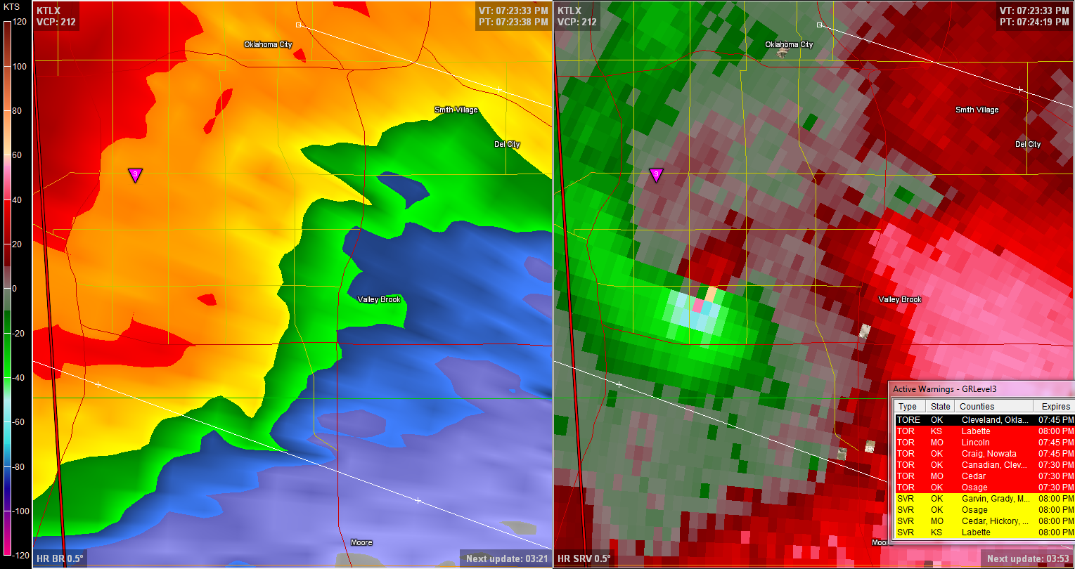
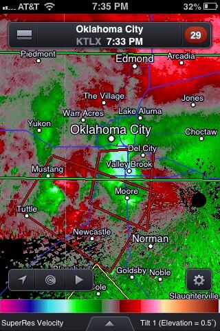
Multi-day outbreak of May 25-31

U.S. & Caribbean Weather Discussions and Severe Weather Events

Moderator: S2k Moderators

Forum rules

The posts in this forum are NOT official forecast and should not be used as such. They are just the opinion of the poster and may or may not be backed by sound meteorological data. They are NOT endorsed by any professional institution or STORM2K.

Help Support Storm2K
Message
Author
User avatar
Cyclenall
Category 5
Category 5
Posts: 6666
Joined: Thu Jun 08, 2006 10:01 pm
Location: Ontario, Canada

Re: Re:

#361 Postby Cyclenall » Fri May 31, 2013 7:24 pm

Bunkertor wrote:
Cyclenall wrote:There is no live footage of OKC? This is beyond insane now, just nuts. Supercells with tornadoes forming right behind too...

Sandridge cam OKC
Image

Thanks man.

EF-5bigj wrote:It's rain wrapped and violent. On foxnews they have video you can not see a thing.

Yeah, this is bad because nothing is being shown. All I know is there are power flashes being reported.
0 likes   

User avatar
Bunkertor
Category 5
Category 5
Posts: 3397
Joined: Tue May 09, 2006 3:48 pm

#362 Postby Bunkertor » Fri May 31, 2013 7:25 pm

That is the gastank i was talking about
Image
0 likes   

RL3AO
Moderator-Pro Met
Moderator-Pro Met
Posts: 16308
Joined: Thu Jun 14, 2007 10:03 pm
Location: NC

#363 Postby RL3AO » Fri May 31, 2013 7:26 pm

Vortex really tightened up last pass.

Image
0 likes   

EF-5bigj
Category 3
Category 3
Posts: 864
Joined: Tue Feb 07, 2012 10:36 pm
Location: Spartanburg,SC

#364 Postby EF-5bigj » Fri May 31, 2013 7:27 pm

Man the sky is dark very very dark and ominous.
0 likes   

User avatar
TeamPlayersBlue
Category 5
Category 5
Posts: 3445
Joined: Tue Feb 02, 2010 1:44 am
Location: Denver/Applewood, CO

#365 Postby TeamPlayersBlue » Fri May 31, 2013 7:27 pm

That image looks crazy with the velocity coming into the storm. Unreal
0 likes   
Personal Forecast Disclaimer:
The posts in this forum are NOT official forecast and should not be used as such. They are just the opinion of the poster and may or may not be backed by sound meteorological data. They are NOT endorsed by any professional institution or storm2k.org. For official information, please refer to the NHC and NWS products.

CrazyC83
Professional-Met
Professional-Met
Posts: 34002
Joined: Tue Mar 07, 2006 11:57 pm
Location: Deep South, for the first time!

#366 Postby CrazyC83 » Fri May 31, 2013 7:28 pm

All those cars on I-35 and I-40 are a catastrophe waiting to happen.
0 likes   

apocalypt-flyer
Category 1
Category 1
Posts: 468
Joined: Sat Aug 27, 2005 11:51 am

#367 Postby apocalypt-flyer » Fri May 31, 2013 7:28 pm

Lots of power-flashes now. Looks bad for the area between I40, I35, I240 and I44.

I35 is a parking lot. Really bad scenario.
0 likes   

CrazyC83
Professional-Met
Professional-Met
Posts: 34002
Joined: Tue Mar 07, 2006 11:57 pm
Location: Deep South, for the first time!

Re:

#368 Postby CrazyC83 » Fri May 31, 2013 7:30 pm

apocalypt-flyer wrote:Lots of power-flashes now. Looks bad for the area between I40, I35, I240 and I44.

I35 is a parking lot. Really bad scenario.


They need to do anything they can! Even an EF-2 tornado can be deadly in cars.
0 likes   

RL3AO
Moderator-Pro Met
Moderator-Pro Met
Posts: 16308
Joined: Thu Jun 14, 2007 10:03 pm
Location: NC

#369 Postby RL3AO » Fri May 31, 2013 7:30 pm

Velocity couplet has moved SE over past 10 minutes. Now moving near North Moore.
0 likes   

User avatar
brunota2003
S2K Supporter
S2K Supporter
Posts: 9476
Age: 34
Joined: Sat Jul 30, 2005 9:56 pm
Location: Stanton, KY...formerly Havelock, NC
Contact:

Re:

#370 Postby brunota2003 » Fri May 31, 2013 7:30 pm

Bunkertor wrote:That is the gastank i was talking about
Image

Most likely propane venting. If it is liquid form, it is "vaporizing".
0 likes   
Just a small town southern boy helping other humans.

caneseddy
Category 5
Category 5
Posts: 1172
Joined: Fri Sep 03, 2004 9:31 pm
Location: Plantation, FL

Re:

#371 Postby caneseddy » Fri May 31, 2013 7:31 pm

RL3AO wrote:Velocity couplet has moved SE over past 10 minutes. Now moving near North Moore.


Oh no :(
0 likes   

spadilly
Tropical Wave
Tropical Wave
Posts: 3
Joined: Sat Aug 27, 2005 3:24 pm

#372 Postby spadilly » Fri May 31, 2013 7:32 pm

I cannot believe how many people are stuck on the roads in OKC. They had so many warnings and so much time to get ready.
Unreal.

Rotation near both Mustang, OK and Valley Brooke, OK. Wow.


Personal Forecast Disclaimer:
The posts in this forum are NOT official forecast and should not be used as such. They are just the opinion of the poster and may or may not be backed by sound meteorological data. They are NOT endorsed by any professional institution or storm2k.org. For official information, please refer to the NHC and NWS products.
0 likes   

EF-5bigj
Category 3
Category 3
Posts: 864
Joined: Tue Feb 07, 2012 10:36 pm
Location: Spartanburg,SC

#373 Postby EF-5bigj » Fri May 31, 2013 7:32 pm

Power flashes :(
0 likes   

RL3AO
Moderator-Pro Met
Moderator-Pro Met
Posts: 16308
Joined: Thu Jun 14, 2007 10:03 pm
Location: NC

Re: Multi-day outbreak for most of this week

#374 Postby RL3AO » Fri May 31, 2013 7:32 pm

Mike Bettes is lucky to be alive.

Image
0 likes   

User avatar
SouthDadeFish
Professional-Met
Professional-Met
Posts: 2835
Joined: Thu Sep 23, 2010 2:54 pm
Location: Miami, FL
Contact:

#375 Postby SouthDadeFish » Fri May 31, 2013 7:34 pm

There are more circulations developing behind the OKC one. Multiple threats.
0 likes   

CrazyC83
Professional-Met
Professional-Met
Posts: 34002
Joined: Tue Mar 07, 2006 11:57 pm
Location: Deep South, for the first time!

#376 Postby CrazyC83 » Fri May 31, 2013 7:34 pm

I feel like the death toll is going to be incredible...and preventable. Most of the deaths I think will be outdoors or in vehicles.
0 likes   

User avatar
SouthDadeFish
Professional-Met
Professional-Met
Posts: 2835
Joined: Thu Sep 23, 2010 2:54 pm
Location: Miami, FL
Contact:

#377 Postby SouthDadeFish » Fri May 31, 2013 7:36 pm

The cell that moved through Mustang is tightening up and Newcastle and Moore are under a tornado warning.
0 likes   

spadilly
Tropical Wave
Tropical Wave
Posts: 3
Joined: Sat Aug 27, 2005 3:24 pm

Re: Multi-day outbreak for most of this week

#378 Postby spadilly » Fri May 31, 2013 7:37 pm

Here is a capture from RadarScope of the velocities:

Image
0 likes   

EF-5bigj
Category 3
Category 3
Posts: 864
Joined: Tue Feb 07, 2012 10:36 pm
Location: Spartanburg,SC

#379 Postby EF-5bigj » Fri May 31, 2013 7:38 pm

The inflow looks insane on these storms.
0 likes   

RL3AO
Moderator-Pro Met
Moderator-Pro Met
Posts: 16308
Joined: Thu Jun 14, 2007 10:03 pm
Location: NC

#380 Postby RL3AO » Fri May 31, 2013 7:38 pm

Mustang cell really getting its act together. Moore and Norman under threat from that one.
0 likes   


Return to “USA & Caribbean Weather”

Who is online

Users browsing this forum: utpmg and 13 guests