ATL: ANDREA - Post-Tropical
Moderator: S2k Moderators
-
Dean4Storms
- S2K Supporter

- Posts: 6358
- Age: 62
- Joined: Sun Aug 31, 2003 1:01 pm
- Location: Miramar Bch. FL
Noting a low level circulation this morning near 89.5W/24.5N
Last edited by Dean4Storms on Tue Jun 04, 2013 7:53 am, edited 1 time in total.
0 likes
-
tolakram
- Admin

- Posts: 20168
- Age: 62
- Joined: Sun Aug 27, 2006 8:23 pm
- Location: Florence, KY (name is Mark)
Re: ATL: INVEST 91L
Latest MIMIC-TPW loop shows circulation off the tip of the Yucatan.
Saved image: http://imageshack.us/a/img209/1714/zzmi ... t72hrs.gif
Saved image: http://imageshack.us/a/img209/1714/zzmi ... t72hrs.gif
0 likes
M a r k
- - - - -
Join us in chat: Storm2K Chatroom Invite. Android and IOS apps also available.
The posts in this forum are NOT official forecasts and should not be used as such. Posts are NOT endorsed by any professional institution or STORM2K.org. For official information and forecasts, please refer to NHC and NWS products.
-
cycloneye

- Admin
- Posts: 148658
- Age: 69
- Joined: Thu Oct 10, 2002 10:54 am
- Location: San Juan, Puerto Rico
Re: ATL: INVEST 91L
Joe Bastardi @BigJoeBastardi 8m
Low level circulation may be starting near 25 north and 89.5 west pic.twitter.com/fLyFYuUMwY
https://twitter.com/BigJoeBastardi
Low level circulation may be starting near 25 north and 89.5 west pic.twitter.com/fLyFYuUMwY
https://twitter.com/BigJoeBastardi
0 likes
Visit the Caribbean-Central America Weather Thread where you can find at first post web cams,radars
and observations from Caribbean basin members Click Here
and observations from Caribbean basin members Click Here
-
Dean4Storms
- S2K Supporter
- Posts: 6358
- Age: 62
- Joined: Sun Aug 31, 2003 1:01 pm
- Location: Miramar Bch. FL
Re: ATL: INVEST 91L
cycloneye wrote:Joe Bastardi @BigJoeBastardi 8m
Low level circulation may be starting near 25 north and 89.5 west pic.twitter.com/fLyFYuUMwY
https://twitter.com/BigJoeBastardi
That's the one I'm seeing. Clear spin and at low level.
0 likes
-
cycloneye
- Admin
- Posts: 148658
- Age: 69
- Joined: Thu Oct 10, 2002 10:54 am
- Location: San Juan, Puerto Rico
Re: ATL: INVEST 91L
12z Best track coincides with JB.
AL, 91, 2013060412, , BEST, 0, 243N, 893W, 25, 1009, DB
AL, 91, 2013060412, , BEST, 0, 243N, 893W, 25, 1009, DB
0 likes
Visit the Caribbean-Central America Weather Thread where you can find at first post web cams,radars
and observations from Caribbean basin members Click Here
and observations from Caribbean basin members Click Here
-
tolakram
- Admin
- Posts: 20168
- Age: 62
- Joined: Sun Aug 27, 2006 8:23 pm
- Location: Florence, KY (name is Mark)
Re: ATL: INVEST 91L
cycloneye wrote:Joe Bastardi @BigJoeBastardi 8m
Low level circulation may be starting near 25 north and 89.5 west pic.twitter.com/fLyFYuUMwY
https://twitter.com/BigJoeBastardi
It's the area just below the westward moving spiral. If he's right then that spiral, if it holds together, should start moving SW ans then S around the larger center.
http://wwwghcc.msfc.nasa.gov/cgi-bin/ge ... umframes=5
0 likes
M a r k
- - - - -
Join us in chat: Storm2K Chatroom Invite. Android and IOS apps also available.
The posts in this forum are NOT official forecasts and should not be used as such. Posts are NOT endorsed by any professional institution or STORM2K.org. For official information and forecasts, please refer to NHC and NWS products.
- - - - -
Join us in chat: Storm2K Chatroom Invite. Android and IOS apps also available.
The posts in this forum are NOT official forecasts and should not be used as such. Posts are NOT endorsed by any professional institution or STORM2K.org. For official information and forecasts, please refer to NHC and NWS products.
-
jlauderdal
- S2K Supporter
- Posts: 7240
- Joined: Wed May 19, 2004 5:46 am
- Location: NE Fort Lauderdale
- Contact:
Re:
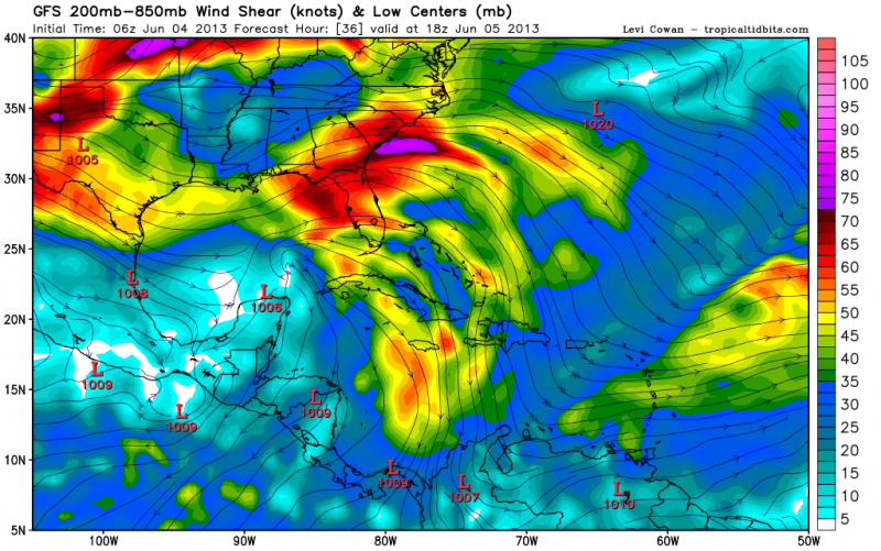
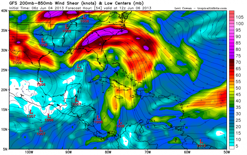
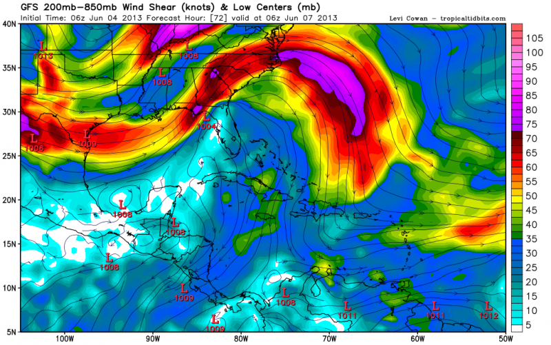
NDG wrote:Here is the GFS shear forecast over the next 72 hrs, it shows shear to diminish Wednesday and early Thursday ahead of the next trough of low pressure but as the low merges with the trough for it to acquire more of subtropical or extratropical entitiy.
http://i20.photobucket.com/albums/b245/ ... 6842fd.png
http://i20.photobucket.com/albums/b245/ ... 9ddfbb.png
http://i20.photobucket.com/albums/b245/ ... 2c60e1.png
impending doom for whatever develops
0 likes
-
jlauderdal
- S2K Supporter
- Posts: 7240
- Joined: Wed May 19, 2004 5:46 am
- Location: NE Fort Lauderdale
- Contact:
Re: ATL: INVEST 91L
weatherwindow wrote:With respect to the current substantial shear, modelling earlier in the week, particularly the GFS and Euro, were suggesting that the shear would ease as the front/trough along the Gulf coast lifted to the Northeast. Is that solution still in the cards or will the shear r
remain? Any comment from the pros or the ams?...Rich
PS...The Lower Keys will need kayaks soon if the rain persists:)
PPS....Front Street in Key West was under 2' of water at high tide last nite
front street has been flooded twice already in the past month, we are having trouble getting anything significant going in SE Florida, dynamics are crappy for anything to get going, severe looks totally really unlikely for today and rain totals look meager, lets see what tomorrow brings
0 likes
-
tropicwatch

- Category 5

- Posts: 3426
- Age: 62
- Joined: Sat Jun 02, 2007 10:01 am
- Location: Panama City Florida
- Contact:
Re: ATL: INVEST 91L - Models
The model plots came together pretty quickly on this one. Now all they need to do is shift a little further west  I know I am being a little selfish but we need rain.
0 likes
Tropicwatch
Agnes 72', Eloise 75, Elena 85', Kate 85', Charley 86', Florence 88', Beryl 94', Dean 95', Erin 95', Opal 95', Earl 98', Georges 98', Ivan 2004', Arlene 2005', Dennis 2005', Ida 2009' Debby 2012' Irma 2017' Michael 2018'
Agnes 72', Eloise 75, Elena 85', Kate 85', Charley 86', Florence 88', Beryl 94', Dean 95', Erin 95', Opal 95', Earl 98', Georges 98', Ivan 2004', Arlene 2005', Dennis 2005', Ida 2009' Debby 2012' Irma 2017' Michael 2018'

Re: ATL: INVEST 91L
Greetings from a wet Cozumel. Just pulling into port on the Carnival Paradise. Heavy rain right now with pretty gusty winds and low ceilings. Looks like a drinking day!
0 likes
-
Dean4Storms
- S2K Supporter
- Posts: 6358
- Age: 62
- Joined: Sun Aug 31, 2003 1:01 pm
- Location: Miramar Bch. FL
Re: ATL: INVEST 91L
N2FSU wrote:Greetings from a wet Cozumel. Just pulling into port on the Carnival Paradise. Heavy rain right now with pretty gusty winds and low ceilings. Looks like a drinking day!
Tequila flows like water down there!
0 likes
-
wxman57

- Moderator-Pro Met

- Posts: 23115
- Age: 68
- Joined: Sat Jun 21, 2003 8:06 pm
- Location: Houston, TX (southwest)
Re: ATL: INVEST 91L
I don't think that the swirl near 24.5N/89.5W is the place to look for development. I saw 2-3 such swirls yesterday, all rotating around a broad area of low pressure. Follow the convection - that's where any low will form (not the other way around).
0 likes


Re: ATL: INVEST 91L - Models
[quote="panamatropicwatch"]The model plots came together pretty quickly on this one. Now all they need to do is shift a little further west I know I am being a little selfish but we need rain.[/quote]
PTW. I've all but given up on this one...it looks like we are destined to be on the dry side of this one. Maybe we'll be able to get a good shower or two out of it. Anything would be better than nothing.
PTW. I've all but given up on this one...it looks like we are destined to be on the dry side of this one. Maybe we'll be able to get a good shower or two out of it. Anything would be better than nothing.
0 likes
-
wzrgirl1

- S2K Supporter
- Posts: 1360
- Joined: Sat Sep 04, 2004 6:44 am
- Location: Pembroke Pines, Florida
Re:
NDG wrote:Looking at the water vapor loop this morning you can tell that the mid and upper level conditions are starting to change a little bit.
Please be more specific. For the worse or for the better in terms of development?
0 likes
Re: ATL: INVEST 91L
wxman57 wrote:I don't think that the swirl near 24.5N/89.5W is the place to look for development. I saw 2-3 such swirls yesterday, all rotating around a broad area of low pressure. Follow the convection - that's where any low will form (not the other way around).
Yeah, I agree, it appears to be more like an eddy drifting away from a broader circulation near the Yucatan Peninsula.
0 likes
Re: Re:
wzrgirl1 wrote:NDG wrote:Looking at the water vapor loop this morning you can tell that the mid and upper level conditions are starting to change a little bit.
Please be more specific. For the worse or for the better in terms of development?
For the better of development. Latest shear map shows near 20 knots across the eastern GOM when yesterday was closer to 30 knots.

0 likes

Re: ATL: INVEST 91L
Has Aric Dunn made any synopsis this morning? WXman57 is spot on with the ejecting vorts, but the convection may have only a mid-level circ, if anything...my eyes may be playing tricks on me with only one cup of joe thusfar! GM folks!
0 likes
-
jlauderdal
- S2K Supporter
- Posts: 7240
- Joined: Wed May 19, 2004 5:46 am
- Location: NE Fort Lauderdale
- Contact:
Re: ATL: INVEST 91L
N2FSU wrote:Greetings from a wet Cozumel. Just pulling into port on the Carnival Paradise. Heavy rain right now with pretty gusty winds and low ceilings. Looks like a drinking day!
if you are on a carnival cruise you have much bigger concerns then a tropical system,
0 likes
Who is online
Users browsing this forum: No registered users and 18 guests