Latest models are in amazing agreement. Path looks like it’s set in stone. The only real differences are the strength upon landfall in panhandle. GFS has been stubborn with the split and all have it weak there. Almost total agreement (including the Canadian) on strength and position around Hatteras. Even if it does reach tropical storm strength around Hatteras I doubt it will be named.
There is one thing I am thankful for, that it is June.
Can you imagine the projected path if this developed in September. Historical.
ATL: ANDREA - Post-Tropical
Moderator: S2k Moderators
-
OuterBanker
- S2K Supporter

- Posts: 1761
- Joined: Wed Feb 26, 2003 10:53 am
- Location: Nags Head, NC
- Contact:
Re: ATL: INVEST 91L
0 likes
-
jlauderdal
- S2K Supporter
- Posts: 7240
- Joined: Wed May 19, 2004 5:46 am
- Location: NE Fort Lauderdale
- Contact:
Re: ATL: INVEST 91L
cycloneye wrote:Up to 40%
TROPICAL WEATHER OUTLOOK
NWS NATIONAL HURRICANE CENTER MIAMI FL
ISSUED BY THE HYDROMETEOROLOGICAL PREDICTION CENTER COLLEGE PARK MD
200 PM EDT TUE JUN 4 2013
SHOWERS AND THUNDERSTORMS ASSOCIATED WITH A BROAD AREA OF LOW
PRESSURE OVER THE CENTRAL GULF OF MEXICO REMAIN DISORGANIZED AND
LOCATED WELL EAST AND SOUTHEAST OF THE CENTER. ENVIRONMENTAL
CONDITIONS COULD BECOME A LITTLE MORE CONDUCIVE FOR DEVELOPMENT
DURING THE NEXT DAY OR TWO..BEFORE THE LOW INTERACTS WITH AN UPPER
LEVEL TROUGH. THIS SYSTEM HAS A MEDIUM CHANCE..40 PERCENT..OF
BECOMING A SUBTROPICAL OR TROPICAL CYCLONE DURING THE NEXT 48 HOURS
AS IT MOVES SLOWLY NORTHWARD OR NORTH-NORTHEASTWARD. REGARDLESS OF
DEVELOPMENT...LOCALLY HEAVY RAINS ARE LIKELY TO CONTINUE OVER THE
NORTHEASTERN YUCATAN PENINSULA..CENTRAL AND WESTERN CUBA...AS WELL
AS THE FLORIDA KEYS AND THE FLORIDA PENINSULA DURING THE NEXT
SEVERAL DAYS.
ELSEWHERE..TROPICAL CYCLONE FORMATION IS NOT EXPECTED DURING THE
NEXT 48 HOURS.
$$
FORECASTER TERRY
i bet the chances top off around 60% then start to diminish, this thing really doesn't have a much of a window to get going, nonetheless its been an interesting start to the season...put a system in this position 60 days from now and we will be at 60 pages of posts
0 likes
-
JonathanBelles
- Professional-Met

- Posts: 11430
- Age: 35
- Joined: Sat Dec 24, 2005 9:00 pm
- Location: School: Florida State University (Tallahassee, FL) Home: St. Petersburg, Florida
- Contact:

-
wxman57

- Moderator-Pro Met

- Posts: 23170
- Age: 68
- Joined: Sat Jun 21, 2003 8:06 pm
- Location: Houston, TX (southwest)
Re: ATL: INVEST 91L
jlauderdal wrote:i bet the chances top off around 60% then start to diminish, this thing really doesn't have a much of a window to get going, nonetheless its been an interesting start to the season...put a system in this position 60 days from now and we will be at 60 pages of posts
Sounds likely. By this evening's update, the 48 hour point is just before the center reaches the FL coast. By tomorrow morning's update, 48 hours will extend out to where the low is over eastern GA/SC. So we should see a ramp-up in development probabilities tonight as the development period is within 48 hrs but not beyond.
0 likes
-
JonathanBelles
- Professional-Met
- Posts: 11430
- Age: 35
- Joined: Sat Dec 24, 2005 9:00 pm
- Location: School: Florida State University (Tallahassee, FL) Home: St. Petersburg, Florida
- Contact:

Re:
[quote="Dean4Storms"]RPM into Appalachicola.....
https://twitter.com/spann/status/341939 ... 13/photo/1[/quote]
What's kind of intriguing is that if this does develope in to a TS and move towards the northern FL Panhandle the weather obviously is all going to be displaced well to the East so it's conceivable that we could have the COC come as close as say 50-75 miles of us yet experience no impacts whatsoever from this.
0 likes
-
ozonepete
- Professional-Met
- Posts: 4743
- Joined: Mon Sep 07, 2009 3:23 pm
- Location: From Ozone Park, NYC / Now in Brooklyn, NY
Re: ATL: INVEST 91L
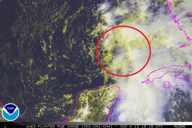
The smaller LLCs that keep forming to the west aren't cutting it, and it looks like the general COC (mid-levels) is shifting into the area I circled.

0 likes

Re: ATL: INVEST 91L
Latest satellite wind analysis with a 20-knot wind field to the NE of the COC
http://rammb.cira.colostate.edu/product ... 1306041800
http://rammb.cira.colostate.edu/product ... 1306041800
0 likes
-
Aric Dunn
- Category 5

- Posts: 21238
- Age: 43
- Joined: Sun Sep 19, 2004 9:58 pm
- Location: Ready for the Chase.
- Contact:
Re: ATL: INVEST 91L
ozonepete wrote:The smaller LLCs that keep forming to the west aren't cutting it, and it looks like the general COC (mid-levels) is shifting into the area I circled.
http://i189.photobucket.com/albums/z174/philnyc_2007/satrgb2013-06-041915anno_zps0f18a09c.jpg
agreed. every little bit of convection that builds a new vort gets spit out. appears the upper environment is becoming more divergent hence the convection building north. may only be another 12 to 18 hr to get it going but of course depends on convection
0 likes
Note: If I make a post that is brief. Please refer back to previous posts for the analysis or reasoning. I do not re-write/qoute what my initial post said each time.
If there is nothing before... then just ask
Space & Atmospheric Physicist, Embry-Riddle Aeronautical University,
I believe the sky is falling...
If there is nothing before... then just ask
Space & Atmospheric Physicist, Embry-Riddle Aeronautical University,
I believe the sky is falling...
-
gatorcane

- S2K Supporter
- Posts: 23708
- Age: 48
- Joined: Sun Mar 13, 2005 3:54 pm
- Location: Boca Raton, FL
NWS Tampa discussion mentions the Tornado possibility. Here is a snippet from their latest discussion, an interesting read for sure:
THERE REMAINS CONCERN FOR TORNADOES IN WEST CENTRAL AND
SOUTHWEST FLORIDA...MAINLY ON THURSDAY. THE CONCERN IS DUE TO THE
AVAILABILITY OF A LOW LEVEL JET ON THE RIGHT SIDE OF THE LOW
PRESSURE SYSTEM...LCL HEIGHTS BETWEEN 500-700 FT...AND HIGH AMOUNTS
OF AVAILABLE SHEAR. THE POTENTIAL FOR A HIGH SHEAR/LOW CAPE
TORNADO EVENT REMAINS AND WILL NEED TO BE MONITORED AS THE SYSTEM
NEARS THE AREA.
0-1 KM HELICITY VALUES BEGIN TO INCREASE BY 00Z THURSDAY IN
SOUTHWEST FLORIDA...WITH VALUES NEAR 100 M2/S2 IN THE 00Z ECMWF AND
100-150 M2/S2 IN THE 12Z GFS. THE 12Z NAM IS MUCH QUIETER ON THIS
FRONT...AS IT KEEPS THE MORE FAVORABLE DYNAMICS AND THE LOW PRESSURE
SYSTEM FURTHER INTO THE GULF.
BY 12Z THURSDAY...THE FAVORABLE DYNAMICS BEGIN TO SPREAD ACROSS
THE WEST COAST OF FLORIDA. 12Z 0-1 KM HELICITY VALUES OF 100 TO
300 M2/S2 ARE SEEN IN THE 12Z GFS...00Z ECMWF...AND EVEN THE 12Z
NAM. 0-1 KM BULK SHEAR VECTORS REACH AN ALARMING 35 TO 45 KNOTS IN
THE GFS AT 12Z THURSDAY. AT 18Z THURSDAY...WITH PEAK DIURNAL
HEATING AND THE LOW SITTING SOMEWHERE OFFSHORE ...PORTIONS OF THE
NATURE COAST CONTINUE WITH 0-1 KM BULK SHEAR VALUES BETWEEN 30-35
KT.
http://forecast.weather.gov/product.php ... glossary=1
Last edited by gatorcane on Tue Jun 04, 2013 3:05 pm, edited 3 times in total.
0 likes
Re: ATL: INVEST 91L
Maybe the first sign of the 200mb PV anomaly beginning to dissipate.
http://tropic.ssec.wisc.edu/real-time/a ... g8vor1.GIF
Still have the 1C inversion keeping a cap on convection.
http://rammb.cira.colostate.edu/product ... 4_TANO.GIF
Much better looking on lower-level vorticities.
http://tropic.ssec.wisc.edu/real-time/a ... g8vor2.GIF
http://tropic.ssec.wisc.edu/real-time/a ... g8vor3.GIF
http://tropic.ssec.wisc.edu/real-time/a ... g8vor3.GIF
Shear dropping
http://tropic.ssec.wisc.edu/real-time/a ... wg8sht.GIF
Somewhat getting its act together.
A hot-tower would definitely do the trick.
0 likes
Re:
JonathanBelles wrote:Tornadoes/waterspouts are becoming a problem for the Dry Tortugas. Numerous spouts are visible on radar out of Key West.
Showing an STP of 2
http://www.spc.noaa.gov/exper/mesoanaly ... 0376250493
0 likes
-
ozonepete
- Professional-Met
- Posts: 4743
- Joined: Mon Sep 07, 2009 3:23 pm
- Location: From Ozone Park, NYC / Now in Brooklyn, NY
Re: ATL: INVEST 91L
GCANE wrote:Maybe the first sign of the 200mb PV anomaly beginning to dissipate.
http://tropic.ssec.wisc.edu/real-time/a ... g8vor1.GIF
Still have the 1C inversion keeping a cap on convection.
http://rammb.cira.colostate.edu/product ... 4_TANO.GIF
Much better looking on lower-level vorticities.
http://tropic.ssec.wisc.edu/real-time/a ... g8vor2.GIF
http://tropic.ssec.wisc.edu/real-time/a ... g8vor3.GIF
http://tropic.ssec.wisc.edu/real-time/a ... g8vor3.GIF
Shear dropping
http://tropic.ssec.wisc.edu/real-time/a ... wg8sht.GIF
Somewhat getting its act together.
A hot-tower would definitely do the trick.
Yeah, it still has a chance. I'd only give it 50/50 right now since the entire circulation is visibly moving north already, albeit slowly. It has a really short window of time but nice SSTs below it and lowering shear as you pointed out.
0 likes
-
cycloneye

- Admin

- Posts: 149130
- Age: 69
- Joined: Thu Oct 10, 2002 10:54 am
- Location: San Juan, Puerto Rico
Re: ATL: INVEST 91L
Off-Topic= Breaking News at Talking Tropics forum about GOES-13.Go here
0 likes
Visit the Caribbean-Central America Weather Thread where you can find at first post web cams,radars
and observations from Caribbean basin members Click Here
and observations from Caribbean basin members Click Here

Re: ATL: INVEST 91L
Good stuff GCANE, keep it coming. I Will be fine with some clouds over SE LA. and maybe some needed rainfall in NW FLA. and southern GA.
0 likes
The following post is NOT an official forecast and should not be used as such. It is just the opinion of the poster and may or may not be backed by sound meteorological data. It is NOT endorsed by any professional institution including storm2k.org For Official Information please refer to the NHC and NWS products.

Re: ATL: INVEST 91L
Small Eddies keep shooting out of the mid level circulation all rotating around the larger circulation just north of the Yucatan Peninsula.
0 likes
Re: ATL: INVEST 91L
tailgater wrote:Good stuff GCANE, keep it coming. I Will be fine with some clouds over SE LA. and maybe some needed rainfall in NW FLA. and southern GA.
Thanks Tailgater - will do
0 likes
Re: ATL: INVEST 91L
Welcome to the new season 
All this talk of rain for SFL and hasn't rained much at all.
All this talk of rain for SFL and hasn't rained much at all.
0 likes
-
Aric Dunn
- Category 5
- Posts: 21238
- Age: 43
- Joined: Sun Sep 19, 2004 9:58 pm
- Location: Ready for the Chase.
- Contact:
Re: ATL: INVEST 91L
Finally a line of convergence has developed with one of these vorts ( in other words what would eventually become a feeder band). A sign things may be starting to consolidate. the vort may rotate back down that line a do a much smaller cyclonic loop than the previous vort has. Then it should tuck under the convection probably where the mid lvl vort is. that should get it going. shear has dropped to below 20kt .... anywhere from 10 to 20kts which is much more manageable.

0 likes
Note: If I make a post that is brief. Please refer back to previous posts for the analysis or reasoning. I do not re-write/qoute what my initial post said each time.
If there is nothing before... then just ask
Space & Atmospheric Physicist, Embry-Riddle Aeronautical University,
I believe the sky is falling...
If there is nothing before... then just ask
Space & Atmospheric Physicist, Embry-Riddle Aeronautical University,
I believe the sky is falling...
-
wzrgirl1

- S2K Supporter
- Posts: 1360
- Joined: Sat Sep 04, 2004 6:44 am
- Location: Pembroke Pines, Florida
Re: ATL: INVEST 91L
tgenius wrote:Welcome to the new season
All this talk of rain for SFL and hasn't rained much at all.
I don't believe it was forecasted until late Wednesday, early Thursday. It's coming.....
0 likes
Who is online
Users browsing this forum: No registered users and 16 guests