
ATL: ANDREA - Post-Tropical
Moderator: S2k Moderators
-
Aric Dunn
- Category 5

- Posts: 21238
- Age: 43
- Joined: Sun Sep 19, 2004 9:58 pm
- Location: Ready for the Chase.
- Contact:
Re: ATL: INVEST 91L
moister on the increase across the northern gulf real quick will spread to the western flank of the system over night.
0 likes
Note: If I make a post that is brief. Please refer back to previous posts for the analysis or reasoning. I do not re-write/qoute what my initial post said each time.
If there is nothing before... then just ask
Space & Atmospheric Physicist, Embry-Riddle Aeronautical University,
I believe the sky is falling...
If there is nothing before... then just ask
Space & Atmospheric Physicist, Embry-Riddle Aeronautical University,
I believe the sky is falling...
-
ozonepete
- Professional-Met

- Posts: 4743
- Joined: Mon Sep 07, 2009 3:23 pm
- Location: From Ozone Park, NYC / Now in Brooklyn, NY
Re:
JonathanBelles wrote:This is a bit of long read, but here is my post on Eye on Weather for the night:
http://jonathanbelles.wordpress.com/201 ... round-91l/
Nice, Jonathan. You are a real asset to storm2k. And hello for the 2013 season.
0 likes
-
OuterBanker
- S2K Supporter

- Posts: 1761
- Joined: Wed Feb 26, 2003 10:53 am
- Location: Nags Head, NC
- Contact:
Re: ATL: INVEST 91L - Models
Good old goofdl. Several hundred miles different than any other model 
0 likes
-
ozonepete
- Professional-Met
- Posts: 4743
- Joined: Mon Sep 07, 2009 3:23 pm
- Location: From Ozone Park, NYC / Now in Brooklyn, NY
Re:
Annie Oakley wrote:Ahhhh............you have to read this thread as a developing story backed by scientific data and human expertise.
And read Jonathon Belles cause he rocks lol.
Hi Annie! And for anyone who wants to know what we are about, they should go look at how we did with Sandy. The proof is there that we try hard and we care.
Sorry a little off topic. Back to 91L.
0 likes

Re: ATL: INVEST 91L - Models
OuterBanker wrote:Good old goofdl. Several hundred miles different than any other model
yeah, haha, I thought that interesting.
0 likes
-
Dave

- Retired Staff

- Posts: 13442
- Age: 75
- Joined: Tue Aug 01, 2006 3:57 pm
- Location: Milan Indiana
- Contact:
Re: Re:
cycloneye wrote:Annie Oakley wrote:Ahhhh............you have to read this thread as a developing story backed by scientific data and human expertise.
That is why S2k is one of the best places to be in the net when weather and the tropics are concerned and especially when the hurricane seasons come.
It's nice to be back with all of you this year. All health problems taken care of and I"m at 100% and ready to pick up where I left off at the end of July last year!
0 likes
-
ozonepete
- Professional-Met
- Posts: 4743
- Joined: Mon Sep 07, 2009 3:23 pm
- Location: From Ozone Park, NYC / Now in Brooklyn, NY
Re: Re:
Dave wrote:It's nice to be back with all of you this year. All health problems taken care of and I"m at 100% and ready to pick up where I left off at the end of July last year!
Welcome back buddy! There's gonna be a lot of RECON to watch this season.
0 likes
-
Dave
- Retired Staff
- Posts: 13442
- Age: 75
- Joined: Tue Aug 01, 2006 3:57 pm
- Location: Milan Indiana
- Contact:
Re: Re:
ozonepete wrote:Dave wrote:It's nice to be back with all of you this year. All health problems taken care of and I"m at 100% and ready to pick up where I left off at the end of July last year!
Welcome back buddy! There's gonna be a lot of RECON to watch this season.
Thanks! Already set & ready to go for 'wheels up' once again....let's do it.
**Now back on topic**
0 likes
Re:
JonathanBelles wrote:This is a bit of long read, but here is my post on Eye on Weather for the night:
http://jonathanbelles.wordpress.com/201 ... round-91l/
Good read and simple to understand
0 likes
-
wxman57

- Moderator-Pro Met

- Posts: 23170
- Age: 68
- Joined: Sat Jun 21, 2003 8:06 pm
- Location: Houston, TX (southwest)
Re: ATL: INVEST 91L
91L appears to be on-track as per model forecasts this evening. Not particularly impressive convection-wise, but I never expected it to look impressive. NHC will have to decide if the weak LLC is strong enough to call a TD or subtropical depression tomorrow afternoon. For that, it needs to develop convection A LOT closer to the circulation. Don't know if it'll make it tomorrow. Regardless, I expect a weak low (1003-1005mb) to make "landfall" in the northern FL Peninsula Thursday evening. May not be very much near the center at that time. Winds on the coast up to 30-40 mph south of the track, not much to the north. Over land, maybe 15-25 mph. Most if not all rain right of the track. Whether the NHC calls it a TD or TS, that's about the most I expect it'll be for Florida.
0 likes
-
weatherwindow

- Category 4

- Posts: 904
- Joined: Mon Sep 20, 2004 9:48 am
- Location: key west/ft lauderdale
Re: ATL: INVEST 91L
Welcome back Dave...good to see you safe and sound...not just metaphorically:D Always reassuring to have the "old dogs" back on the premises . Greetings from Key West....Rich
0 likes
Re: ATL: INVEST 91L
wxman57 wrote:91L appears to be on-track as per model forecasts this evening. Not particularly impressive convection-wise, but I never expected it to look impressive. NHC will have to decide if the weak LLC is strong enough to call a TD or subtropical depression tomorrow afternoon. For that, it needs to develop convection A LOT closer to the circulation. Don't know if it'll make it tomorrow. Regardless, I expect a weak low (1003-1005mb) to make "landfall" in the northern FL Peninsula Thursday evening. May not be very much near the center at that time. Winds on the coast up to 30-40 mph south of the track, not much to the north. Over land, maybe 15-25 mph. Most if not all rain right of the track. Whether the NHC calls it a TD or TS, that's about the most I expect it'll be for Florida.
That seems like a good call. I do think there's some potential for some flood issues especially if rainbands train over our urban areas and some tornado potential. I'm envisioning a less severe version of Debby which caused most of her mischief via freshwater flooding and tornadoes.
0 likes
-
ozonepete
- Professional-Met
- Posts: 4743
- Joined: Mon Sep 07, 2009 3:23 pm
- Location: From Ozone Park, NYC / Now in Brooklyn, NY
Re: ATL: INVEST 91L
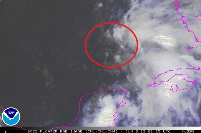
My latest guess as to where the MLC is. It's still shifting around a lot, but the one to the SE of there will not win out.

0 likes
-
Dave
- Retired Staff
- Posts: 13442
- Age: 75
- Joined: Tue Aug 01, 2006 3:57 pm
- Location: Milan Indiana
- Contact:
Re:
CrazyC83 wrote:I hope to do as much as I can, but I am working towards a Pro Met position myself...
That made my day CrazyC83 go for it! And weatherwindow...thank you but watch the 'old' dog stuff a little!
I'll see ya all in the morning....Take care & stay safe where ever you are! (Maybe if I leave it'll actually stay on topic...just feels good to be back home again)
0 likes
-
gatorcane

- S2K Supporter
- Posts: 23708
- Age: 48
- Joined: Sun Mar 13, 2005 3:54 pm
- Location: Boca Raton, FL
buoy data for a buoy at 26N, 85W..pressure dropping and winds increasing:

http://www.ndbc.noaa.gov/station_page.php?station=42003
http://www.ndbc.noaa.gov/station_page.php?station=42003
Last edited by gatorcane on Tue Jun 04, 2013 9:24 pm, edited 1 time in total.
0 likes
-
SouthDadeFish

- Professional-Met
- Posts: 2835
- Joined: Thu Sep 23, 2010 2:54 pm
- Location: Miami, FL
- Contact:

I will be paying attention to buoy 42003, the mid level circulation seems to be tracking towards or close to this buoy, which by the way a few minutes ago reported the strongest winds so far out of this buoy.
Conditions at 42003 as of
(8:50 pm CDT on 06/04/2013)
0150 GMT on 06/05/2013: .
Wind Direction (WDIR): SE ( 130 deg true )
Wind Speed (WSPD): 23.3 kts
Wind Gust (GST): 29.1 kts
Wave Height (WVHT): 6.6 ft
Dominant Wave Period (DPD): 8 sec
Average Period (APD): 4.9 sec
Mean Wave Direction (MWD): SE ( 134 deg true )
Atmospheric Pressure (PRES): 29.89 in
Pressure Tendency (PTDY): +0.00 in ( Steady )
Air Temperature (ATMP): 80.1 °F
Water Temperature (WTMP): 81.3 °F
Wind Speed at 10 meters (WSPD10M): 25.3 kts
Wind Speed at 20 meters (WSPD20M): 27.2 kts
Combined plot of Wind Speed, Gust, and Air Pressure
http://www.ndbc.noaa.gov/station_page.php?station=42003
0 likes
-
Evil Jeremy

- S2K Supporter
- Posts: 5463
- Age: 32
- Joined: Mon Apr 10, 2006 2:10 pm
- Location: Los Angeles, CA
Re: ATL: INVEST 91L
I think the NHC will raise the TWO precentage at 2am. I'd put it at 60 percent personally. 91L is pulling itself together tonight. Can't wait for the first recon of the season tomorrow!
0 likes
Frances 04 / Jeanne 04 / Katrina 05 / Wilma 05 / Fay 08 / Debby 12 / Andrea 13 / Colin 16 / Hermine 16 / Matthew 16 / Irma 17
-
Hurricaneman

- Category 5
- Posts: 7404
- Age: 45
- Joined: Tue Aug 31, 2004 3:24 pm
- Location: central florida
Re:
NDG wrote:I will be paying attention to buoy 42003, the mid level circulation seems to be tracking towards or close to this buoy, which by the way a few minutes ago reported the strongest winds so far out of this buoy.
Conditions at 42003 as of
(8:50 pm CDT on 06/04/2013)
0150 GMT on 06/05/2013: .
Wind Direction (WDIR): SE ( 130 deg true )
Wind Speed (WSPD): 23.3 kts
Wind Gust (GST): 29.1 kts
Wave Height (WVHT): 6.6 ft
Dominant Wave Period (DPD): 8 sec
Average Period (APD): 4.9 sec
Mean Wave Direction (MWD): SE ( 134 deg true )
Atmospheric Pressure (PRES): 29.89 in
Pressure Tendency (PTDY): +0.00 in ( Steady )
Air Temperature (ATMP): 80.1 °F
Water Temperature (WTMP): 81.3 °F
Wind Speed at 10 meters (WSPD10M): 25.3 kts
Wind Speed at 20 meters (WSPD20M): 27.2 kts
Combined plot of Wind Speed, Gust, and Air Pressure
http://www.ndbc.noaa.gov/station_page.php?station=42003
If these obs are true it may be a depression at the moment and this may be Andrea by tomorrow afternoon, but I may be looking too much into the obs
0 likes
Who is online
Users browsing this forum: No registered users and 14 guests