ATL: ANDREA - Post-Tropical

Moderator: S2k Moderators

Message
Author
User avatar
wxman57
Moderator-Pro Met
Moderator-Pro Met
Posts: 22978
Age: 67
Joined: Sat Jun 21, 2003 8:06 pm
Location: Houston, TX (southwest)

Re: ATL: INVEST 91L

#401 Postby wxman57 » Tue Jun 04, 2013 9:36 pm

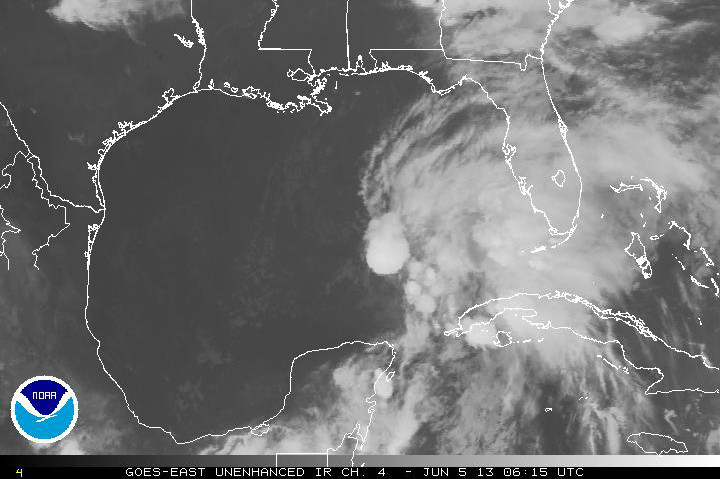
Evil Jeremy wrote:I think the NHC will raise the TWO precentage at 2am. I'd put it at 60 percent personally. 91L is pulling itself together tonight. Can't wait for the first recon of the season tomorrow!


60% is about right, but not because it looks more impressive now, because it now has less than a 48hr window to develop and that's the max I was thinking prior to it moving into FL Thursday evening. Don't know if it'll make TD tomorrow, fair chance Thursday morning.
0 likes   

Javlin
Category 5
Category 5
Posts: 1620
Age: 64
Joined: Fri Jul 09, 2004 7:58 pm
Location: ms gulf coast

Re: ATL: INVEST 91L

#402 Postby Javlin » Tue Jun 04, 2013 9:36 pm

Dvorak showing some good rotation @24N88W it seems.....

http://www.ssd.noaa.gov/goes/east/gmex/flash-bd.html
0 likes   

JonathanBelles
Professional-Met
Professional-Met
Posts: 11430
Age: 35
Joined: Sat Dec 24, 2005 9:00 pm
Location: School: Florida State University (Tallahassee, FL) Home: St. Petersburg, Florida
Contact:

#403 Postby JonathanBelles » Tue Jun 04, 2013 10:02 pm

There is a graphic that I am not allowed to share here on my twitter (@JonathanBelles) that is a must see. Tonight's D2 and Thursday's severe weather outlook just got a lot more interesting.
0 likes   

Aric Dunn
Category 5
Category 5
Posts: 21238
Age: 42
Joined: Sun Sep 19, 2004 9:58 pm
Location: Ready for the Chase.
Contact:

#404 Postby Aric Dunn » Tue Jun 04, 2013 10:19 pm

looking more an more like the mlc to the east is going to spawn a dominate llc if not already.
0 likes   
Note: If I make a post that is brief. Please refer back to previous posts for the analysis or reasoning. I do not re-write/qoute what my initial post said each time.
If there is nothing before... then just ask :)

Space & Atmospheric Physicist, Embry-Riddle Aeronautical University,
I believe the sky is falling...

User avatar
weatherSnoop
S2K Supporter
S2K Supporter
Posts: 702
Age: 62
Joined: Wed Oct 09, 2002 10:06 pm
Location: Tampa, FL
Contact:

Re: Re:

#405 Postby weatherSnoop » Tue Jun 04, 2013 10:24 pm

cycloneye wrote:
Annie Oakley wrote:Ahhhh............you have to read this thread as a developing story backed by scientific data and human expertise.


That is why S2k is one of the best places to be in the net when weather and the tropics are concerned and especially when the hurricane seasons come. :)


Second that, Cycloneye. I rely on this site all year round
0 likes   

User avatar
artist
Category 5
Category 5
Posts: 9792
Joined: Mon Jun 06, 2005 3:26 pm
Location: West Palm

Re:

#406 Postby artist » Tue Jun 04, 2013 10:26 pm

JonathanBelles wrote:There is a graphic that I am not allowed to share here on my twitter (@JonathanBelles) that is a must see. Tonight's D2 and Thursday's severe weather outlook just got a lot more interesting.

I just looked at it. Interesting. Went to SPC and day 2 shows not much and here is day 3's outlook -
...FL/SOUTHEAST STATES...
THE EVOLUTION OF AN AREA OF LOW PRESSURE ACROSS THE EASTERN GULF OF
MEXICO WILL BE MONITORED OVER SUBSEQUENT DAYS...WITH THE POSSIBILITY
THAT THIS FEATURE COULD SPREAD NORTHEASTWARD/INLAND SOMEWHERE ACROSS
FL. WHILE AN INCREASINGLY MOIST AIRMASS AND A RELATIVELY STRONG
LOW-LEVEL WIND FIELD MAY ACCOMPANY THIS LOW...CONSIDERATION OF LOW
SEVERE PROBABILITIES /NAMELY MINI-SUPERCELL POTENTIAL/ APPEARS TOO
LOW/SPECULATIVE AT THIS JUNCTURE.

..GUYER.. 06/04/2013
0 likes   

Ikester
Professional-Met
Professional-Met
Posts: 361
Age: 39
Joined: Mon Jun 21, 2010 5:00 pm
Location: Jacksonville, FL

Re: ATL: INVEST 91L

#407 Postby Ikester » Tue Jun 04, 2013 10:29 pm

JonathanBelles!! Dude, I kept asking myself "where do I know that name from???" Then I logged on to my facebook and there was your post about the helicities. Bottom line is, I had a eureka moment tonight! Was great. Okay, back to the subject at hand. :cheesy:
0 likes   

User avatar
Evil Jeremy
S2K Supporter
S2K Supporter
Posts: 5463
Age: 32
Joined: Mon Apr 10, 2006 2:10 pm
Location: Los Angeles, CA

Re:

#408 Postby Evil Jeremy » Tue Jun 04, 2013 10:31 pm

Aric Dunn wrote:looking more an more like the mlc to the east is going to spawn a dominate llc if not already.


What implications would that have on the track?
0 likes   
Frances 04 / Jeanne 04 / Katrina 05 / Wilma 05 / Fay 08 / Debby 12 / Andrea 13 / Colin 16 / Hermine 16 / Matthew 16 / Irma 17

User avatar
jaguarjace
Category 4
Category 4
Posts: 975
Age: 30
Joined: Sat Jun 11, 2011 7:38 am
Location: Khon Kaen, Thailand

ATL: INVEST 91L

#409 Postby jaguarjace » Tue Jun 04, 2013 10:43 pm

psyclone wrote:I'm envisioning a less severe version of Debby which caused most of her mischief via freshwater flooding and tornadoes.

I can definitely see 91L being a much weaker version of Debby:
[youtube]http://www.youtube.com/watch?v=_MwDpjslf14[/youtube]
0 likes   
Owner of the Tropical Archive YouTube channel
Web Developer at Force Thirteen
Twitter/X : @force13_support

Ikester
Professional-Met
Professional-Met
Posts: 361
Age: 39
Joined: Mon Jun 21, 2010 5:00 pm
Location: Jacksonville, FL

Re: ATL: INVEST 91L

#410 Postby Ikester » Tue Jun 04, 2013 11:05 pm

If the RPM model is to be believed, this storm won't produce the widespread, catastrophic flooding to the likes of Debby. Our RPM model at the station (at least per the 12z run) only shows between 1 and 2 inches for the Jacksonville viewing area which extends as far west as Columbia and Suwannee counties with upwards of 4-7 inches in the Tallahassee area. I suspect the later runs of the RPM will show an increase for our area as PW's are expected to top 2'' by Wednesday and 700 mb moisture tops 90%. Due to dynamics and the release of latent heat more so at night in a naturally cooler environment, the heaviest of the rains are likely to occur Thursday night as the storm moves inland imo.

This storm is NOT Debby. Debby crawled across the peninsula. Invest 91L is going to scoot on out of here pretty quick. The 00z GFS (initialized 06052013) has this low off Cape Hatteras by 15z Friday. The ECMWF has it over Savannah at 12z Friday and over Boston at 12z Saturday. So the Euro is a bit slower. Bottom line, I think flooding will be confined to the typical low-lying drainage areas (at least for Jacksonville) which is welcome news for sure. Not to mention, the state could use a bit of rain to keep the wild fire season at bay.
0 likes   

User avatar
ROCK
Category 5
Category 5
Posts: 9484
Age: 54
Joined: Tue Aug 17, 2004 7:30 am
Location: Kemah, Texas

Re: ATL: INVEST 91L

#411 Postby ROCK » Tue Jun 04, 2013 11:15 pm

Clouds are warming and convection is not as intense. running out of time to do something, IMO.....need to fully get to the sruface and fire off a Cane "hot tower"..... :D
0 likes   

psyclone
S2K Supporter
S2K Supporter
Posts: 4762
Joined: Wed Aug 24, 2005 9:04 pm
Location: palm harbor fl

Re: ATL: INVEST 91L

#412 Postby psyclone » Tue Jun 04, 2013 11:18 pm

Ikester wrote:If the RPM model is to be believed, this storm won't produce the widespread, catastrophic flooding to the likes of Debby. Our RPM model at the station (at least per the 12z run) only shows between 1 and 2 inches for the Jacksonville viewing area which extends as far west as Columbia and Suwannee counties with upwards of 4-7 inches in the Tallahassee area. I suspect the later runs of the RPM will show an increase for our area as PW's are expected to top 2'' by Wednesday and 700 mb moisture tops 90%. Due to dynamics and the release of latent heat more so at night in a naturally cooler environment, the heaviest of the rains are likely to occur Thursday night as the storm moves inland imo.

This storm is NOT Debby. Debby crawled across the peninsula. Invest 91L is going to scoot on out of here pretty quick. The 00z GFS (initialized 06052013) has this low off Cape Hatteras by 15z Friday. The ECMWF has it over Savannah at 12z Friday and over Boston at 12z Saturday. So the Euro is a bit slower. Bottom line, I think flooding will be confined to the typical low-lying drainage areas (at least for Jacksonville) which is welcome news for sure. Not to mention, the state could use a bit of rain to keep the wild fire season at bay.

One thing that will be interesting to watch for is any long, tail like, feeder band stretching from the low back into the gulf as the low scoots off to the northeast. that's the type of localized feature that could result in a deluge for someone. Of course these types of set ups may or may not materialize but anytime high octane air is getting a lift there is potential.
0 likes   

User avatar
blp
Category 5
Category 5
Posts: 2840
Age: 46
Joined: Thu Sep 09, 2004 7:51 pm
Location: Miami, FL
Contact:

Re:

#413 Postby blp » Tue Jun 04, 2013 11:22 pm

Aric Dunn wrote:looking more an more like the mlc to the east is going to spawn a dominate llc if not already.


I agree I see 23.5 & 86 for the mlc. I can't see how the LLC forms out over 88 with the limited convergence and convection in that area.
0 likes   
The following post is NOT an official forecast and should not be used as such. It is just the opinion of the poster and may or may not be backed by sound meteorological data. It is NOT endorsed by any professional institution including storm2k.org For Official Information please refer to the NHC and NWS products.

User avatar
MGC
S2K Supporter
S2K Supporter
Posts: 5899
Joined: Sun Mar 23, 2003 9:05 pm
Location: Pass Christian MS, or what is left.

Re: ATL: INVEST 91L

#414 Postby MGC » Tue Jun 04, 2013 11:23 pm

Shear is blowing the cloud top to the NE...don't look like the shear is letting up....cloud tops are warming too. Something better get cranking real soon if 91L is going to get upgraded to first class....MGC
0 likes   

User avatar
blp
Category 5
Category 5
Posts: 2840
Age: 46
Joined: Thu Sep 09, 2004 7:51 pm
Location: Miami, FL
Contact:

Re: ATL: INVEST 91L

#415 Postby blp » Tue Jun 04, 2013 11:36 pm

MGC wrote:Shear is blowing the cloud top to the NE...don't look like the shear is letting up....cloud tops are warming too. Something better get cranking real soon if 91L is going to get upgraded to first class....MGC


Shear is still doing its damage but the overall structure has improved.
0 likes   
The following post is NOT an official forecast and should not be used as such. It is just the opinion of the poster and may or may not be backed by sound meteorological data. It is NOT endorsed by any professional institution including storm2k.org For Official Information please refer to the NHC and NWS products.

User avatar
Recurve
Category 5
Category 5
Posts: 1640
Joined: Tue Aug 16, 2005 8:59 pm
Location: St. Petersburg, FL

Re: ATL: INVEST 91L

#416 Postby Recurve » Tue Jun 04, 2013 11:41 pm

wxman57 wrote:91L appears to be on-track as per model forecasts this evening. Not particularly impressive convection-wise, but I never expected it to look impressive. NHC will have to decide if the weak LLC is strong enough to call a TD or subtropical depression tomorrow afternoon. For that, it needs to develop convection A LOT closer to the circulation. Don't know if it'll make it tomorrow. Regardless, I expect a weak low (1003-1005mb) to make "landfall" in the northern FL Peninsula Thursday evening. May not be very much near the center at that time. Winds on the coast up to 30-40 mph south of the track, not much to the north. Over land, maybe 15-25 mph. Most if not all rain right of the track. Whether the NHC calls it a TD or TS, that's about the most I expect it'll be for Florida.


Just catching up here, of course I read Wxman57 and get everything I need to know. (From a few pages back)

This will be my first hurricane season on the mainland, after years in the Keys. Now on high(er) ground in the St. Pete. Yeah, it's a peninsula, but I'm going to breathe a lot easier now that I have miles between me and the surge, instead of blocks. But I'll also be holding my breath for all you all on the coasts. Be safe this season.
0 likes   

User avatar
lester
S2K Supporter
S2K Supporter
Posts: 1305
Age: 36
Joined: Sat Aug 27, 2005 5:21 pm
Location: Washington, DC
Contact:

#417 Postby lester » Wed Jun 05, 2013 12:11 am

1. SHOWERS AND THUNDERSTORMS LOCATED WELL TO THE EAST AND SOUTHEAST OF
A BROAD AREA OF LOW PRESSURE OVER THE CENTRAL GULF OF MEXICO HAVE
CHANGED LITTLE IN ORGANIZATION OVER THE PAST FEW HOURS.
ENVIRONMENTAL CONDITIONS COULD BECOME A LITTLE MORE CONDUCIVE FOR
DEVELOPMENT DURING THE NEXT DAY OR TWO BEFORE THE LOW INTERACTS
WITH AN UPPER-LEVEL TROUGH. THIS SYSTEM HAS A MEDIUM CHANCE...40
PERCENT...OF BECOMING A SUBTROPICAL OR TROPICAL CYCLONE DURING THE
NEXT 48 HOURS AS IT MOVES SLOWLY NORTHWARD ON WEDNESDAY AND BEGINS
TO MOVE MORE QUICKLY NORTHEASTWARD ON THURSDAY. REGARDLESS OF
DEVELOPMENT...LOCALLY HEAVY RAINS ARE LIKELY TO CONTINUE OVER THE
NORTHEASTERN YUCATAN PENINSULA...CENTRAL AND WESTERN CUBA...AS WELL
AS THE FLORIDA KEYS AND THE FLORIDA PENINSULA DURING THE NEXT FEW
DAYS. ADDITIONAL INFORMATION ON THIS SYSTEM CAN BE FOUND IN HIGH
SEAS FORECASTS ISSUED BY THE NATIONAL WEATHER SERVICE...AND IN
PRODUCTS ISSUED BY YOUR LOCAL NATIONAL WEATHER SERVICE OFFICE OR
NATIONAL METEOROLOGICAL SERVICE.
0 likes   

HurricaneHunter914
Category 5
Category 5
Posts: 4439
Age: 31
Joined: Fri Mar 10, 2006 7:36 pm
Location: College Station, TX

#418 Postby HurricaneHunter914 » Wed Jun 05, 2013 1:21 am

http://www.ssd.noaa.gov/PS/TROP/floater ... -long.html

Ball of convection blowing up very close to the center.
0 likes   
Personal Forecast Disclaimer:
The posts in this forum are NOT official forecast and should not be used as such. They are just the opinion of the poster and may or may not be backed by sound meteorological data. They are NOT endorsed by any professional institution or storm2k.org. For official information, please refer to the NHC and NWS products.

User avatar
Fyzn94
Tropical Storm
Tropical Storm
Posts: 190
Joined: Thu Jul 07, 2011 10:00 pm
Location: Central AR, USA

Re: ATL: INVEST 91L

#419 Postby Fyzn94 » Wed Jun 05, 2013 2:15 am

Looking pretty healthy.

Image
0 likes   
NOTICE: I cannot give an expert analysis. Most of my "observations" are made visually with the help of only vital information provided by public advisories.

User avatar
Cyclenall
Category 5
Category 5
Posts: 6666
Joined: Thu Jun 08, 2006 10:01 pm
Location: Ontario, Canada

Re:

#420 Postby Cyclenall » Wed Jun 05, 2013 3:01 am

HurricaneHunter914 wrote:http://www.ssd.noaa.gov/PS/TROP/floaters/91L/flash-avn-long.html

Ball of convection blowing up very close to the center.

I haven't seen you post here in years.

I haven't followed Invest 91L (or 90L, what happened to that?) much but it appears to be a classic June Gulf system, similar to TS Alberto in 2006.
0 likes   


Return to “2013”

Who is online

Users browsing this forum: No registered users and 1 guest