ATL: ANDREA - Post-Tropical
Moderator: S2k Moderators


Re: ATL: INVEST 91L
0 likes
-
HurricaneHunter914
- Category 5

- Posts: 4439
- Age: 32
- Joined: Fri Mar 10, 2006 7:36 pm
- Location: College Station, TX
Re: Re:
Cyclenall wrote:HurricaneHunter914 wrote:http://www.ssd.noaa.gov/PS/TROP/floaters/91L/flash-avn-long.html
Ball of convection blowing up very close to the center.
I haven't seen you post here in years.
I haven't followed Invest 91L (or 90L, what happened to that?) much but it appears to be a classic June Gulf system, similar to TS Alberto in 2006.
Haha, I became a lurker for awhile, but I decided to become a Meteorology major, so I figured its time to go back into the fray.
The next TWO is going to be interesting. This flare up has been fairly persistent and hasn't been sheared off to the east. Could possibly have Andrea before the day's end if this continues.
0 likes
Personal Forecast Disclaimer:
The posts in this forum are NOT official forecast and should not be used as such. They are just the opinion of the poster and may or may not be backed by sound meteorological data. They are NOT endorsed by any professional institution or storm2k.org. For official information, please refer to the NHC and NWS products.
The posts in this forum are NOT official forecast and should not be used as such. They are just the opinion of the poster and may or may not be backed by sound meteorological data. They are NOT endorsed by any professional institution or storm2k.org. For official information, please refer to the NHC and NWS products.

Re: ATL: INVEST 91L
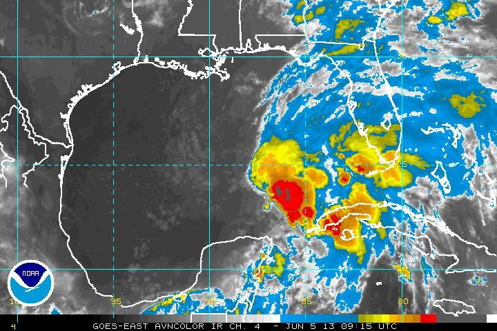
Nice size hot tower beginning to fire off.
Looks like this could be a long duration one.
http://www.nrlmry.navy.mil/htdocs_dyn_a ... xico.0.jpg
Looks like this could be a long duration one.
http://www.nrlmry.navy.mil/htdocs_dyn_a ... xico.0.jpg
0 likes
Re: ATL: INVEST 91L
Hard to tell but it looks like a more defined surface COC or LLC is trying to redevelop closer to the deep convection, near 25N and 87-88W area.
Vis satellite should give us a better picture.
Vis satellite should give us a better picture.
0 likes
Re: ATL: INVEST 91L
Hot Tower is pretty far from the current fixed COC.
http://rammb.cira.colostate.edu/product ... 050845.jpg
However, it is very likely the COC could get pulled closer to it.
http://rammb.cira.colostate.edu/product ... 050845.jpg
However, it is very likely the COC could get pulled closer to it.
0 likes
Re: ATL: INVEST 91L
Not just off-the-scale rain rate, but cloud tops also very cold with the hot-tower - text book
http://www.ssd.noaa.gov/PS/TROP/floater ... imated.gif
http://www.ssd.noaa.gov/PS/TROP/floater ... imated.gif
0 likes
Re: ATL: INVEST 91L
Sorry for being off topic here, but I was just scanning RAP and saw a very nasty set up for OK this afternoon.
Off-scale helicity and CAPE over 4000.
Off-scale helicity and CAPE over 4000.
0 likes
-
Dean4Storms
- S2K Supporter

- Posts: 6358
- Age: 63
- Joined: Sun Aug 31, 2003 1:01 pm
- Location: Miramar Bch. FL


-
caneman
Re: ATL: INVEST 91L
Looking much better this morning. Lopsided yes but you expect that this time of year. Think the LLC will develop under the convection. Looks like we'll have a TD today in my opinion.
0 likes
Re: ATL: INVEST 91L
The off-scale high rain rate only lasted about 1/2 hour, but it continues to fire very cold cloud tops.
0 likes
-
Aric Dunn
- Category 5
- Posts: 21238
- Age: 43
- Joined: Sun Sep 19, 2004 9:58 pm
- Location: Ready for the Chase.
- Contact:
as suspected last night. that vigorious mid lvl citrc had spawned a new wahat appears to be a well defined llc with organized deep convection firing and maintaining. very likely nhc will find a td if not a ts today.
0 likes
Note: If I make a post that is brief. Please refer back to previous posts for the analysis or reasoning. I do not re-write/qoute what my initial post said each time.
If there is nothing before... then just ask
Space & Atmospheric Physicist, Embry-Riddle Aeronautical University,
I believe the sky is falling...
If there is nothing before... then just ask
Space & Atmospheric Physicist, Embry-Riddle Aeronautical University,
I believe the sky is falling...
-
weatherwindow

- Category 4

- Posts: 904
- Joined: Mon Sep 20, 2004 9:48 am
- Location: key west/ft lauderdale
Re: ATL: INVEST 91L
GCANE wrote:Nice size hot tower beginning to fire off.
Looks like this could be a long duration one.
http://www.nrlmry.navy.mil/htdocs_dyn_a ... xico.0.jpg
Good morning, G...hopefully it will persist long enough to start warming the column and give a boost to some anticyclonic assist aloft
0 likes
-
Aric Dunn
- Category 5
- Posts: 21238
- Age: 43
- Joined: Sun Sep 19, 2004 9:58 pm
- Location: Ready for the Chase.
- Contact:
Re: ATL: INVEST 91L
the bouy very the llc has had decent pressure fall and sustainded td winds . probably very like thete are sustained ts winds in the deep convevtion
0 likes
Note: If I make a post that is brief. Please refer back to previous posts for the analysis or reasoning. I do not re-write/qoute what my initial post said each time.
If there is nothing before... then just ask
Space & Atmospheric Physicist, Embry-Riddle Aeronautical University,
I believe the sky is falling...
If there is nothing before... then just ask
Space & Atmospheric Physicist, Embry-Riddle Aeronautical University,
I believe the sky is falling...
Re: ATL: INVEST 91L
Aric Dunn wrote:the bouy very the llc has had decent pressure fall and sustainded td winds . probably very like thete are sustained ts winds in the deep convevtion
http://www.ndbc.noaa.gov/plot_wind_pres ... _label=CDT
And this buoy is no where close to the deep convection which is a good 100-150 miles to the south from this buoy.
0 likes
-
jlauderdal
- S2K Supporter
- Posts: 7240
- Joined: Wed May 19, 2004 5:46 am
- Location: NE Fort Lauderdale
- Contact:
Re: ATL: INVEST 91L
CAPE over 4000 is always worth posting about regardless of the topic, good workGCANE wrote:Sorry for being off topic here, but I was just scanning RAP and saw a very nasty set up for OK this afternoon.
Off-scale helicity and CAPE over 4000.
0 likes
-
jlauderdal
- S2K Supporter
- Posts: 7240
- Joined: Wed May 19, 2004 5:46 am
- Location: NE Fort Lauderdale
- Contact:
Who is online
Users browsing this forum: No registered users and 76 guests