
Cancun Airport reporting WSW winds, 7mph
http://www.hurricanecity.com/wx/cancunobs.htm
ATL: ANDREA - Post-Tropical
Moderator: S2k Moderators


-
gatorcane

- S2K Supporter

- Posts: 23708
- Age: 48
- Joined: Sun Mar 13, 2005 3:54 pm
- Location: Boca Raton, FL
Quite surprised NHC is not already calling this a depression and 50% development chances still seems a little bit on the conservative side.
Here is an update on the Tornado threat for the Tampa Bay area:
THE THREAT FOR TORNADOES IS LESS CERTAIN...BUT SIGNIFICANT SHEAR
WILL EXIST ALONG AND JUST NORTH OF A TROUGH AXIS THAT WILL EXTEND
EASTWARD FROM THE DISTURBANCE AS IT INTERACTS WITH AN APPROACHING
UPPER-LEVEL TROUGH TONIGHT AND THURSDAY. SINCE THE LOW TRACK AND
STRENGTH OF THE SYSTEM ARE STILL IN QUESTION...IT IS DIFFICULT TO
PINPOINT WHEN OR WHERE THE THREAT FOR TORNADOES WILL BE. THE
PREFERRED GUIDANCE WOULD SUGGEST A ZONE FROM THE TAMPA BAY AREA
NORTHWARD STARTING SOMETIME THIS EVENING AND CONTINUING INTO EARLY
THURSDAY.
http://forecast.weather.gov/product.php ... glossary=1
0 likes
-
jlauderdal
- S2K Supporter
- Posts: 7240
- Joined: Wed May 19, 2004 5:46 am
- Location: NE Fort Lauderdale
- Contact:
Re:
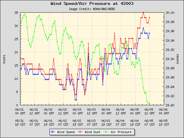
NDG wrote:Buoy 42003 has now being reporting TD force winds for at least 5 hrs straight now, close to 10 foot waves and a pressure of 4 mb lower than 24 hrs ago. All the recon has to find is a defined LLC for 91L to get upgraded to at least our first TD.
http://i20.photobucket.com/albums/b245/ ... 889111.png
correct, if recon can close it off then you have your td/ts..winds and pressure alone wont do it
0 likes
Re: Re:
Sanibel wrote:
I agree. I think the Caribbean wave took over and Barbara's remnants poofed.
Have to bust myself on this. The scat image shows the impetus came from the low pressure remnants of Barbara IMO. The Caribbean wave probably recharged those remnants and combined. Minor point.
Overcast and drizzly here.
0 likes
Re:
gatorcane wrote:Quite surprised NHC is not already calling this a depression and 50% development chances still seems a little bit on the conservative side.
It could be they are laying back because it is forecast to open up into a sheared elongated mess of a Low tomorrow.
0 likes
-
wxman57

- Moderator-Pro Met

- Posts: 23175
- Age: 68
- Joined: Sat Jun 21, 2003 8:06 pm
- Location: Houston, TX (southwest)
Re: ATL: INVEST 91L
I'm looking at the 00Z Euro 10m winds in 3hr increments and see a max of 30-35 kts east of Hatteras in 72 hours. Over land - wind 5-15 kts.
0 likes
Re: Re:
jlauderdal wrote:NDG wrote:Buoy 42003 has now being reporting TD force winds for at least 5 hrs straight now, close to 10 foot waves and a pressure of 4 mb lower than 24 hrs ago. All the recon has to find is a defined LLC for 91L to get upgraded to at least our first TD.
http://i20.photobucket.com/albums/b245/ ... 889111.png
correct, if recon can close it off then you have your td/ts..winds and pressure alone wont do it
But I just wanted to correct you that it does have a closed circulation, it just needs a defined LLC close to the deep convection.
I have been studying Tropical Cyclones since I was a little kid, 30 years ago, I know what qualifies it to be a TD, TS...etc
0 likes
-
Dean4Storms
- S2K Supporter
- Posts: 6358
- Age: 63
- Joined: Sun Aug 31, 2003 1:01 pm
- Location: Miramar Bch. FL
Re: ATL: INVEST 91L
wxman57 wrote:I'm looking at the 00Z Euro 10m winds in 3hr increments and see a max of 30-35 kts east of Hatteras in 72 hours. Over land - wind 5-15 kts.
Does it show any of the 25-30 knot winds any where close to buoy 42003 for this morning?
0 likes
-
hurricanefloyd5

- Category 5

- Posts: 1659
- Age: 45
- Joined: Sun May 02, 2004 10:53 am
- Location: Spartanburg
- Contact:
Re:
Dean4Storms wrote:If this is accurate we have a Tropical Depression......
http://rammb.cira.colostate.edu/product ... 1306050600
Think recon we'll find that we have a tropical depression or possibly tropical storm Andrea today. how will it affect my getaway this weekend. I am going on a small trip this weekend down by the airport with some friends. I will be cut off from all communication for the most part
0 likes
-
tropicwatch

- Category 5
- Posts: 3427
- Age: 62
- Joined: Sat Jun 02, 2007 10:01 am
- Location: The Villages, Florida
- Contact:
Re: ATL: INVEST 91L
Buoy reports in the GOM:
Station 42003
NDBC
Location: 26.044N 85.612W
Date: Wed, 5 Jun 2013 12:50:00 UTC
Winds: ESE (110°) at 27.2 kt gusting to 31.1 kt
Significant Wave Height: 8.9 ft
Dominant Wave Period: 6 sec
Mean Wave Direction: ESE (112°)
Atmospheric Pressure: 29.83 in and rising
Air Temperature: 77.9 F
Water Temperature: 81.5 F
This is relatively NE of the system.
Station 42001
NDBC
Location: 25.888N 89.658W
Date: Wed, 5 Jun 2013 12:50:00 UTC
Winds: ENE (70°) at 13.6 kt gusting to 15.5 kt
Significant Wave Height: 5.9 ft
Dominant Wave Period: 8 sec
Atmospheric Pressure: 29.80 in and rising
Air Temperature: 80.1 F
Dew Point: 74.8 F
Water Temperature: 80.4 F
This is relatively NW of the system.
Pressures are fairly low.
0 likes
Tropicwatch
Agnes 72', Eloise 75, Elena 85', Kate 85', Charley 86', Florence 88', Beryl 94', Dean 95', Erin 95', Opal 95', Earl 98', Georges 98', Ivan 2004', Arlene 2005', Dennis 2005', Ida 2009' Debby 2012' Irma 2017' Michael 2018'
Agnes 72', Eloise 75, Elena 85', Kate 85', Charley 86', Florence 88', Beryl 94', Dean 95', Erin 95', Opal 95', Earl 98', Georges 98', Ivan 2004', Arlene 2005', Dennis 2005', Ida 2009' Debby 2012' Irma 2017' Michael 2018'
-
wxman57
- Moderator-Pro Met
- Posts: 23175
- Age: 68
- Joined: Sat Jun 21, 2003 8:06 pm
- Location: Houston, TX (southwest)
Re: ATL: INVEST 91L
NDG wrote:wxman57 wrote:I'm looking at the 00Z Euro 10m winds in 3hr increments and see a max of 30-35 kts east of Hatteras in 72 hours. Over land - wind 5-15 kts.
Does it show any of the 25-30 knot winds any where close to buoy 42003 for this morning?
Sure (see below), that's exactly what it's showing over buoy 42003. I think the low center is still way too broad/ill-defined and lacking any convection near it to call it a TD. Not sure it will make it to TD status today. Maybe tomorrow.
Here's the map valid 12Z today:

0 likes
Re: ATL: INVEST 91L
wxman57 wrote:NDG wrote:wxman57 wrote:I'm looking at the 00Z Euro 10m winds in 3hr increments and see a max of 30-35 kts east of Hatteras in 72 hours. Over land - wind 5-15 kts.
Does it show any of the 25-30 knot winds any where close to buoy 42003 for this morning?
Sure (see below), that's exactly what it's showing over buoy 42003. I think the low center is still way too broad/ill-defined and lacking any convection near it to call it a TD. Not sure it will make it to TD status today. Maybe tomorrow.
Here's the map valid 12Z today:
http://home.comcast.net/~cgh57/ECwinds.gif
Thanks for posting the image.
It sure does show the winds the buoy is reporting this morning.
I think that 91L has only 24-36 hrs to work with the best UL level winds it has to work with before UL winds get even worst, if by tomorrow morning is not a TD or TS I doubt it will be after that, maybe a subtropical or extratropical of some sort gale center after tomorrow if it gets back into the Atlantic waters.
0 likes

Re: ATL: INVEST 91L
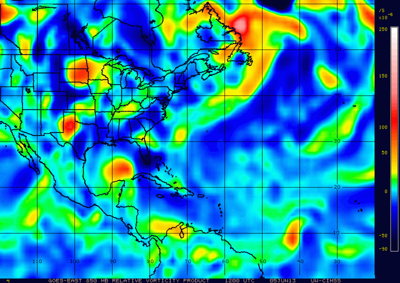
http://www.ssd.noaa.gov/goes/east/gmex/flash-wv.html
dry air still coming out of Texas eating away the western side. Coupled that with moderate shear we have what we see here.
dry air still coming out of Texas eating away the western side. Coupled that with moderate shear we have what we see here.
0 likes
-
adam0983
Re: ATL: INVEST 91L
Invest 91L looks to be winning against the sheer right now. It looks like Andrea will be here soon. Just an opinion not a forecast.
0 likes
-
SouthDadeFish

- Professional-Met

- Posts: 2836
- Joined: Thu Sep 23, 2010 2:54 pm
- Location: Miami, FL
- Contact:

-
Evil Jeremy

- S2K Supporter
- Posts: 5463
- Age: 32
- Joined: Mon Apr 10, 2006 2:10 pm
- Location: Los Angeles, CA
Re: ATL: INVEST 91L
Looks a lot worse than I was expecting after it's improvement last night. Still has work to do, and the clock is ticking.
0 likes
Frances 04 / Jeanne 04 / Katrina 05 / Wilma 05 / Fay 08 / Debby 12 / Andrea 13 / Colin 16 / Hermine 16 / Matthew 16 / Irma 17
-
Dave

- Retired Staff

- Posts: 13442
- Age: 75
- Joined: Tue Aug 01, 2006 3:57 pm
- Location: Milan Indiana
- Contact:
Re:
Extratropical94 wrote:Quick question,
does this line (especially the term "cyclone") mean that they are already expecting 91L to be a numbered system by Thursday?
B. AFXXX 0201A CYCLONE
Possible..really a clear cut answer huh. But normally yes once they change the words from one mission to another then they are expecting it to go up in strength. In reality...we'll know the answer to that once the flights done.
0 likes
Who is online
Users browsing this forum: No registered users and 50 guests