2013 Steering Pattern / Early indicators

This is the general tropical discussion area. Anyone can take their shot at predicting a storms path.

Moderator: S2k Moderators

Forum rules

The posts in this forum are NOT official forecasts and should not be used as such. They are just the opinion of the poster and may or may not be backed by sound meteorological data. They are NOT endorsed by any professional institution or STORM2K. For official information, please refer to products from the National Hurricane Center and National Weather Service.

Help Support Storm2K
Message
Author
User avatar
chaser1
S2K Supporter
S2K Supporter
Posts: 5464
Age: 64
Joined: Sat Oct 15, 2005 5:59 pm
Location: Longwood, Fl

Re: 2013 Steering Pattern / Early indicators

#241 Postby chaser1 » Sat Jun 08, 2013 3:45 pm

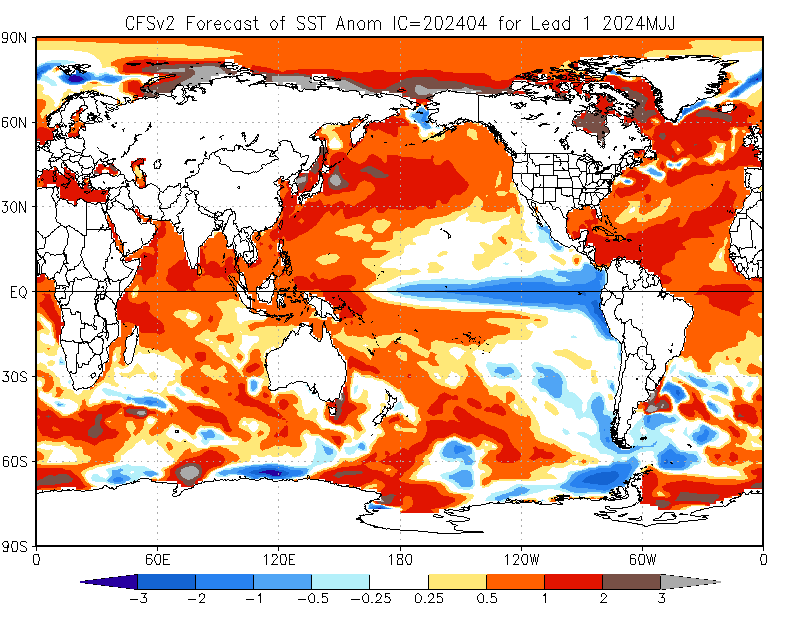
cycloneye wrote:If this pattern stays without much change thru the peak of the season (August,September and October) then it will be an ominous one for the U.S coastline and for the Caribbean.


Yep, could'nt agree more. It will be especially interesting as we approach July though. Usually this is when we REALLY see Atlantic ridging and the Easterlies exert themselves. My guess is that this is when we might see the first "big threat" by a major hurricane, and one that just wants to barrel on westward due to the increased ridging over much of the Atlantic and possibly S.E. US. Such a set up could put the Windwards or Leewards at risk, but perhaps even greater eventual risk to Central America & Yucatan. Hmmm, sounds like another "over/under" poll (different thread though).
0 likes   
Andy D

(For official information, please refer to the NHC and NWS products.)

User avatar
cycloneye
Admin
Admin
Posts: 145310
Age: 68
Joined: Thu Oct 10, 2002 10:54 am
Location: San Juan, Puerto Rico

Re: 2013 Steering Pattern / Early indicators

#242 Postby cycloneye » Sun Jun 09, 2013 11:14 am

The vertical instability on the MDR is near normal at this time.Let's see how it continues to progress as time goes by and the peak of the season approaches.

Image
0 likes   
Visit the Caribbean-Central America Weather Thread where you can find at first post web cams,radars
and observations from Caribbean basin members Click Here

User avatar
Hurricaneman
Category 5
Category 5
Posts: 7351
Age: 45
Joined: Tue Aug 31, 2004 3:24 pm
Location: central florida

Re: 2013 Steering Pattern / Early indicators

#243 Postby Hurricaneman » Sun Jun 09, 2013 3:35 pm

The vertical instability if you add in the Tropical Atlantic, Caribbean, and GOM is above normal, and the MJO is predicted to go into phase 7 aka positive on the Euro by June 24th and GFS goes into phase 7 by june 25th so I believe from July 1st on we will have a major uptick in activity and maybe a Major july hurricane if the shear dies down some, but if the shear stays somewhat the same there will thankfully not be a major landfall so lets hope for shear because I see little to no dry air after June is over
0 likes   

User avatar
cycloneye
Admin
Admin
Posts: 145310
Age: 68
Joined: Thu Oct 10, 2002 10:54 am
Location: San Juan, Puerto Rico

Re: 2013 Steering Pattern / Early indicators

#244 Postby cycloneye » Mon Jun 10, 2013 11:00 am

The folks at the UK have updated the Precipitation and MSLP forecasts for July,August and September and it has a good deal of precipitation in most of MDR and Caribbean. The MSLP s slightly below average in MDR and Caribbean.

Image

Image
0 likes   
Visit the Caribbean-Central America Weather Thread where you can find at first post web cams,radars
and observations from Caribbean basin members Click Here

User avatar
gatorcane
S2K Supporter
S2K Supporter
Posts: 23691
Age: 47
Joined: Sun Mar 13, 2005 3:54 pm
Location: Boca Raton, FL

#245 Postby gatorcane » Mon Jun 10, 2013 3:06 pm

When I look at the Atlantic wide range view today, I see quite a bit of African Dust out there in the MDR. You can see the large area of haze between the Lesser Antilles and Africa.

Even here in South Florida a couple of days ago the NWS mentioned that some African dust invaded the region due to southerly steering flow at 700MB in the wake of Andrea.

is this normal for this time of year? I thought we started seeing this more in July across the tropical Atlantic.

Image
Last edited by gatorcane on Mon Jun 10, 2013 3:08 pm, edited 1 time in total.
0 likes   

User avatar
wxman57
Moderator-Pro Met
Moderator-Pro Met
Posts: 22978
Age: 67
Joined: Sat Jun 21, 2003 8:06 pm
Location: Houston, TX (southwest)

Re: 2013 Steering Pattern / Early indicators

#246 Postby wxman57 » Mon Jun 10, 2013 3:07 pm

June Euro forecast for MSLP anomaly has MUCH higher pressure across the Gulf/Caribbean for August-October than did the May forecast. Center of highest pressure right over Florida. Not sure what this all means now. If it's right, then it would signal less activity in the Gulf/Caribbean than we were thinking.
0 likes   

User avatar
gatorcane
S2K Supporter
S2K Supporter
Posts: 23691
Age: 47
Joined: Sun Mar 13, 2005 3:54 pm
Location: Boca Raton, FL

#247 Postby gatorcane » Mon Jun 10, 2013 3:27 pm

With all the hype about this season, that is certainly an interesting prediction by the ECMWF and could be great news for us in Florida if it is right.

Is there a link for this Euro MSLP anomaly forecast you are referring to or is it a paid site?
0 likes   

User avatar
cycloneye
Admin
Admin
Posts: 145310
Age: 68
Joined: Thu Oct 10, 2002 10:54 am
Location: San Juan, Puerto Rico

Re: 2013 Steering Pattern / Early indicators

#248 Postby cycloneye » Mon Jun 10, 2013 3:34 pm

The site that I get the MSLP ECMWF forecasts still doesn't have the June forecast which comes out on the 15th of every month. It would be a gamechanger for sure if that forecast is verified.

http://www.ecmwf.int/products/forecasts ... 0summary!/
0 likes   
Visit the Caribbean-Central America Weather Thread where you can find at first post web cams,radars
and observations from Caribbean basin members Click Here

User avatar
wxman57
Moderator-Pro Met
Moderator-Pro Met
Posts: 22978
Age: 67
Joined: Sat Jun 21, 2003 8:06 pm
Location: Houston, TX (southwest)

Re: 2013 Steering Pattern / Early indicators

#249 Postby wxman57 » Mon Jun 10, 2013 3:38 pm

cycloneye wrote:The site that I get the MSLP ECMWF forecasts still doesn't have the June forecast which comes out on the 15th of every month. Unless 57 has another site for that. It would be a gamechanger for sure if that forecast is verified.

http://www.ecmwf.int/products/forecasts ... 0summary!/


That's the site, Luis. We have the full ECMWF so we have access to the forecasts when they are issued near the beginning of each month. It should be uploaded on the free site by around the 20th-22nd.
0 likes   

Alyono
Professional-Met
Professional-Met
Posts: 6961
Joined: Fri Apr 26, 2013 3:52 pm
Location: Texas Coast

#250 Postby Alyono » Mon Jun 10, 2013 4:03 pm

or it shows the EC is highly inconsistent in terms of seasonal forecasts
0 likes   

User avatar
TropicalAnalystwx13
Category 5
Category 5
Posts: 2109
Age: 27
Joined: Tue Jul 19, 2011 8:20 pm
Location: Wilmington, NC
Contact:

Re:

#251 Postby TropicalAnalystwx13 » Mon Jun 10, 2013 4:28 pm

Alyono wrote:or it shows the EC is highly inconsistent in terms of seasonal forecasts

Exactly. The ECMWF showed much higher pressures and an El Niño last year as well (which is why it's showing higher pressures this year).
0 likes   

User avatar
SFLcane
S2K Supporter
S2K Supporter
Posts: 10163
Age: 47
Joined: Sat Jun 05, 2010 1:44 pm
Location: Lake Worth Florida

Re: 2013 Steering Pattern / Early indicators

#252 Postby SFLcane » Mon Jun 10, 2013 6:23 pm

CFS teaming with ECM you gotta be kidding me? El nino.. Who knows what the cards hold this season.

Image
0 likes   

User avatar
cycloneye
Admin
Admin
Posts: 145310
Age: 68
Joined: Thu Oct 10, 2002 10:54 am
Location: San Juan, Puerto Rico

Re: 2013 Steering Pattern / Early indicators

#253 Postby cycloneye » Mon Jun 10, 2013 6:26 pm

If what our friend wxman57 brought to this thread earlier about the ECMWF MSLP June forecast was a bomb news with the expectations by the experts of a very active season,now comes this from CFSv2 for July. Higher pressures in Atlantic.

Image
0 likes   
Visit the Caribbean-Central America Weather Thread where you can find at first post web cams,radars
and observations from Caribbean basin members Click Here

User avatar
Cyclenall
Category 5
Category 5
Posts: 6666
Joined: Thu Jun 08, 2006 10:01 pm
Location: Ontario, Canada

So one Euro seasonal run is a possible gamechanger? LOL

#254 Postby Cyclenall » Mon Jun 10, 2013 6:27 pm

wxman57 wrote:June Euro forecast for MSLP anomaly has MUCH higher pressure across the Gulf/Caribbean for August-October than did the May forecast. Center of highest pressure right over Florida. Not sure what this all means now. If it's right, then it would signal less activity in the Gulf/Caribbean than we were thinking.

I'd toss it but does it even mean anything if all the systems come from outside of that region? Unless there is physical blocking of high pressure at the time, its not like a major hurricane is going to approach the area and hit a wall and turn around.

TropicalAnalystwx13 wrote:
Alyono wrote:or it shows the EC is highly inconsistent in terms of seasonal forecasts

Exactly. The ECMWF showed much higher pressures and an El Niño last year as well (which is why it's showing higher pressures this year).

I second this. Its flip flopping on this one so I wouldn't pay much attention to it.
0 likes   

User avatar
Ntxw
Storm2k Moderator
Storm2k Moderator
Posts: 22785
Joined: Wed Oct 21, 2009 6:34 pm
Location: DFW, Texas

#255 Postby Ntxw » Mon Jun 10, 2013 6:43 pm

I'd like to bring some added thoughts regarding the ENSO look from the models. Firstly, if El Nino were to come on (this is a very low if) definitely would not be in time for peak hurricane season, at best warm neutral. Models flip flop according to intra-seasonal variability with the MJO. Warming and cooling comes in cycles during neutral and the models over aggressively predicts one or the other during that period.

Secondly, last month the PDO did rise which adversely effects NA weather and the locations of big highs in NA and just downstream in the ATL. Cold PDO obviously is better for the Atlantic basin, this month's update should be in the coming days and will be telling of where ENSO and the overall favored patterns in the northern hemisphere will steer.
Last edited by Ntxw on Mon Jun 10, 2013 6:44 pm, edited 1 time in total.
0 likes   
The above post and any post by Ntxw is NOT an official forecast and should not be used as such. It is just the opinion of the poster and may or may not be backed by sound meteorological data. It is NOT endorsed by any professional institution including Storm2k. For official information, please refer to NWS products.

  Help support Storm2K!
Help Support Storm2K

User avatar
TropicalAnalystwx13
Category 5
Category 5
Posts: 2109
Age: 27
Joined: Tue Jul 19, 2011 8:20 pm
Location: Wilmington, NC
Contact:

#256 Postby TropicalAnalystwx13 » Mon Jun 10, 2013 6:43 pm

Though admittedly...the CFS and UKMET do show a more unfavorable pattern as well.

I think more than anything this shows us models remain very split on what the state of the ENSO should be for hurricane season, which isn't surprising. Neutral conditions in the equatorial Pacific typically don't last very long. When they do, the models have a tendency to switch it to either an El Nino or a La Nina. That's why some are favorable for the Atlantic right now and others are not.
0 likes   

User avatar
cycloneye
Admin
Admin
Posts: 145310
Age: 68
Joined: Thu Oct 10, 2002 10:54 am
Location: San Juan, Puerto Rico

Re:

#257 Postby cycloneye » Mon Jun 10, 2013 6:48 pm

Ntxw wrote:I'd like to bring some added thoughts regarding the ENSO look from the models. Firstly, if El Nino were to come on (this is a very low if) definitely would not be in time for peak hurricane season, at best warm neutral. Models flip flop according to intra-seasonal variability with the MJO. Warming and cooling comes in cycles during neutral and the models over aggressively predicts one or the other during that period.

Secondly, last month the PDO did rise which adversely effects NA weather and the locations of big highs in NA and just downstream in the ATL. Cold PDO obviously is better for the Atlantic basin, this month's update should be in the coming days and will be telling of where ENSO and the overall favored patterns in the northern hemisphere will steer.


+1

Agree is late for El Nino to be present on ASO as it has to be three consecutive months of over +0.5C Right now Nino 3.4 is at -0.2C.
0 likes   
Visit the Caribbean-Central America Weather Thread where you can find at first post web cams,radars
and observations from Caribbean basin members Click Here

TheStormExpert

Re: Re:

#258 Postby TheStormExpert » Mon Jun 10, 2013 7:31 pm

Exactly. The ECMWF showed much higher pressures and an El Niño last year as well (which is why it's showing higher pressures this year).

The ECMWF has basically been doing (IMO) horrible overall for the past year! First real example I remember was it showing TS Debby from last year heading towards Texas verses the GFS which had it going towards Florida.
0 likes   

User avatar
NDG
S2K Supporter
S2K Supporter
Posts: 15446
Joined: Sun Jul 09, 2006 10:14 pm
Location: Orlando, FL

Re: 2013 Steering Pattern / Early indicators

#259 Postby NDG » Mon Jun 10, 2013 7:57 pm

After last year's ENSO forecast bust by the ECMWF, I take its forecast with a grain of salt.
It has been flipping back and forth so far this year. If it at least would had been persistent it would had been another story, IMO.
0 likes   

User avatar
NDG
S2K Supporter
S2K Supporter
Posts: 15446
Joined: Sun Jul 09, 2006 10:14 pm
Location: Orlando, FL

Re: Re:

#260 Postby NDG » Mon Jun 10, 2013 8:00 pm

TheStormExpert wrote:
Exactly. The ECMWF showed much higher pressures and an El Niño last year as well (which is why it's showing higher pressures this year).

The ECMWF has basically been doing (IMO) horrible overall for the past year! First real example I remember was it showing TS Debby from last year heading towards Texas verses the GFS which had it going towards Florida.


And just this year it was showing Andrea to form and head towards LA/MS.
0 likes   


Return to “Talkin' Tropics”

Who is online

Users browsing this forum: abajan, Stratton23 and 39 guests