ENSO Updates (2007 thru 2023)

This is the general tropical discussion area. Anyone can take their shot at predicting a storms path.

Moderator: S2k Moderators

Forum rules

The posts in this forum are NOT official forecasts and should not be used as such. They are just the opinion of the poster and may or may not be backed by sound meteorological data. They are NOT endorsed by any professional institution or STORM2K. For official information, please refer to products from the National Hurricane Center and National Weather Service.

Help Support Storm2K
Message
Author
User avatar
SoupBone
Category 5
Category 5
Posts: 3111
Joined: Tue Sep 20, 2005 5:24 pm

Re:

#3021 Postby SoupBone » Fri Jun 14, 2013 9:51 am

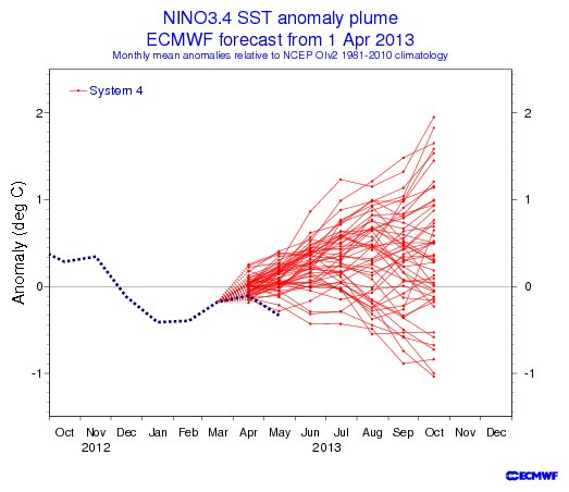
Ntxw wrote:Ok folks lets lay this El Nino stuff to rest. There is no El Nino or La Nina, we are in neutral and will stay there likely through peak tropical season. Wxman57 only mentioned that the Euro looked warmer than before he didn't say an El Nino was coming. The only changes is that the PDO rose to positive and sub-surface waters transitioned against the cold pool underneath, that is all. CFSv2 has been going warm but it too is very borderline so even it has no confidence and waffles.

I know the term "El Nino" is devil's words in the tropical threads so to prevent panic lets avoid using it unless we are sure it's coming.


Just looking at the 30 and 90 day SOI, it would be difficult to grasp an el Nino event beginning to setup right now. The daily has been positive for all but 5 days in a 30 day period.

http://www.longpaddock.qld.gov.au/seaso ... soivalues/
0 likes   
Personal Forecast Disclaimer:
The posts in this forum are NOT official forecast and should not be used as such. They are just the opinion of the poster and may or may not be backed by sound meteorological data. They are NOT endorsed by any professional institution or storm2k.org. For official information, please refer to the NHC and NWS products.

User avatar
cycloneye
Admin
Admin
Posts: 145330
Age: 68
Joined: Thu Oct 10, 2002 10:54 am
Location: San Juan, Puerto Rico

Re: ENSO Updates

#3022 Postby cycloneye » Fri Jun 14, 2013 10:25 am

El Nino is anywhere to be found now or anytime soon.

Nino 1+2:

Image

Nino 3:

Image

Nino 3.4:

Image

Nino 4:

Image

http://www.tropicaltidbits.com/analysis/ocean.html
0 likes   
Visit the Caribbean-Central America Weather Thread where you can find at first post web cams,radars
and observations from Caribbean basin members Click Here

User avatar
Ntxw
Storm2k Moderator
Storm2k Moderator
Posts: 22785
Joined: Wed Oct 21, 2009 6:34 pm
Location: DFW, Texas

#3023 Postby Ntxw » Fri Jun 14, 2013 11:23 am

:uarrow: Your graphics supports what I thought would occur from earlier in the week that the sub-surface movements are taking place with 1.2 and 3 seeing the biggest differences, lets see if they hold true through Monday's update.

Ntxw wrote:In all even with the newly emerged warm pool it's unlikely we'll see any significant changes in ENSO region 3.4 the next week maybe two. -AAM is currently in place so I don't expect the MJO will make way to bring up the warmer waters by moving into the Pacific. We may even see slight cooling as the cold pool is pushed west with the new emerging warm waters. It is more likely that the Nino regions 1.2 and 3 will see more significant warming compared to the cold states they are now.


Last week
Image

This week
Image
0 likes   
The above post and any post by Ntxw is NOT an official forecast and should not be used as such. It is just the opinion of the poster and may or may not be backed by sound meteorological data. It is NOT endorsed by any professional institution including Storm2k. For official information, please refer to NWS products.

  Help support Storm2K!
Help Support Storm2K

User avatar
TropicalAnalystwx13
Category 5
Category 5
Posts: 2109
Age: 27
Joined: Tue Jul 19, 2011 8:20 pm
Location: Wilmington, NC
Contact:

#3024 Postby TropicalAnalystwx13 » Fri Jun 14, 2013 8:19 pm

I'm expecting a significant modification in equatorial Pacific sea surface temperature anomalies after next week. As has been discussed here, a downwelling Kelvin wave is transporting warm sub-surface SSTs from the western and central Pacific to the eastern Pacific. The upcoming MJO pulse favors low-level westerlies and warming as well. Finally, the AAM is still negative but starting to trend towards its high phase.

If the CFS is correct, all negative anomalies would likely be wiped out by mid-July:

Image
0 likes   

User avatar
cycloneye
Admin
Admin
Posts: 145330
Age: 68
Joined: Thu Oct 10, 2002 10:54 am
Location: San Juan, Puerto Rico

Re: ENSO Updates

#3025 Postby cycloneye » Fri Jun 14, 2013 8:35 pm

As long the SOI continues well above the negative 8 line no El Nino will be around in the next 2-3 of months.

Image
0 likes   
Visit the Caribbean-Central America Weather Thread where you can find at first post web cams,radars
and observations from Caribbean basin members Click Here

User avatar
NDG
S2K Supporter
S2K Supporter
Posts: 15446
Joined: Sun Jul 09, 2006 10:14 pm
Location: Orlando, FL

Re: ENSO Updates

#3026 Postby NDG » Sat Jun 15, 2013 7:44 am

I believe the ECMWF's ENSO Seasonal Range Forecast is being released today, if indeed it shows Nino 3.4 to be nearing to a warm Neutral or to an El Nino threadshold by the heart of this hurricane season, lets just look back at its April forecast.
See how warm bias it has been? Whoever picks this model over the rest is out of their mind.

Image
0 likes   

User avatar
cycloneye
Admin
Admin
Posts: 145330
Age: 68
Joined: Thu Oct 10, 2002 10:54 am
Location: San Juan, Puerto Rico

Re: ENSO Updates

#3027 Postby cycloneye » Sat Jun 15, 2013 8:03 am

:uarrow: The Updated ENSO forecast by ECMWF is not too different than the April one.

Image
0 likes   
Visit the Caribbean-Central America Weather Thread where you can find at first post web cams,radars
and observations from Caribbean basin members Click Here

User avatar
NDG
S2K Supporter
S2K Supporter
Posts: 15446
Joined: Sun Jul 09, 2006 10:14 pm
Location: Orlando, FL

#3028 Postby NDG » Sat Jun 15, 2013 8:26 am

:uarrow: That was last month's, the updated one to be released today should say June.
0 likes   

User avatar
wxman57
Moderator-Pro Met
Moderator-Pro Met
Posts: 22979
Age: 67
Joined: Sat Jun 21, 2003 8:06 pm
Location: Houston, TX (southwest)

Re: ENSO Updates

#3029 Postby wxman57 » Sat Jun 15, 2013 8:44 am

Here's the June forecast, though I'm quite reluctant to believe it given the pool of cool sub-surface water out there.

Image

I'd be more inclined to believe the Australia Bureau of Meteorology's forecast, again, given the amount of cool sub-surface water. And I never trust a forecast that takes a sharp turn instantly at the time of the forecast. In this case, the Euro has the temp dropping up to the forecast time then instantly starts warming.

Image
0 likes   

TheStormExpert

#3030 Postby TheStormExpert » Sat Jun 15, 2013 10:42 am

Of course we are in a Neutral state and the models usually never know what the heck to do when in the Neutral state. :roll:
0 likes   

User avatar
cycloneye
Admin
Admin
Posts: 145330
Age: 68
Joined: Thu Oct 10, 2002 10:54 am
Location: San Juan, Puerto Rico

Re: ENSO Updates

#3031 Postby cycloneye » Sun Jun 16, 2013 10:20 pm

A nice warm pool at the subsurface has grown. Let's see what happens in the next few weeks to see if warming occurs at Nino 3.4.

Image
0 likes   
Visit the Caribbean-Central America Weather Thread where you can find at first post web cams,radars
and observations from Caribbean basin members Click Here

dexterlabio
Category 5
Category 5
Posts: 3468
Joined: Sat Oct 24, 2009 11:50 pm

#3032 Postby dexterlabio » Mon Jun 17, 2013 10:54 am

MJO is approaching Western Pacific and by the end of June/first week of July, it's expected to cross EPAC going to the Caribbean. I wonder if that would deal some warming within the next few days. .
0 likes   
Personal Forecast Disclaimer:
The posts in this forum are NOT official forecast and should not be used as such. They are just the opinion of the poster and may or may not be backed by sound meteorological data. They are NOT endorsed by any professional institution or storm2k.org. For official information, please refer to the NHC and NWS products.

User avatar
Ntxw
Storm2k Moderator
Storm2k Moderator
Posts: 22785
Joined: Wed Oct 21, 2009 6:34 pm
Location: DFW, Texas

#3033 Postby Ntxw » Mon Jun 17, 2013 11:45 am

There was no change to 3.4 this week, 4 cooled slightly and 3 warmed slightly.

dexterlabio wrote:MJO is approaching Western Pacific and by the end of June/first week of July, it's expected to cross EPAC going to the Caribbean. I wonder if that would deal some warming within the next few days. .


Warming looks very likely after one more week of fairly stable SST's this week. If that MJO wave does progress nicely we have a growing pool of very warm waters under the eastern basin to work with. Our friend TropicalAnalystWx made note that late June to July patterns favored warming of the equatorial Pacific, with AAM rising and the new MJO forecasting there is better conclusion that this will occur. To what extent is still yet to be answered.
0 likes   
The above post and any post by Ntxw is NOT an official forecast and should not be used as such. It is just the opinion of the poster and may or may not be backed by sound meteorological data. It is NOT endorsed by any professional institution including Storm2k. For official information, please refer to NWS products.


  Help support Storm2K!

Help Support Storm2K


User avatar
cycloneye
Admin
Admin
Posts: 145330
Age: 68
Joined: Thu Oct 10, 2002 10:54 am
Location: San Juan, Puerto Rico

Re: ENSO Updates

#3034 Postby cycloneye » Mon Jun 17, 2013 11:46 am

Climate Prediction Center 6/17/13 update

No changes of interest to note in this update. Only they mention the warm anomalies in the EastCentral Pacific.

http://www.cpc.ncep.noaa.gov/products/a ... ts-web.pdf
0 likes   
Visit the Caribbean-Central America Weather Thread where you can find at first post web cams,radars
and observations from Caribbean basin members Click Here

User avatar
cycloneye
Admin
Admin
Posts: 145330
Age: 68
Joined: Thu Oct 10, 2002 10:54 am
Location: San Juan, Puerto Rico

Re: ENSO Updates

#3035 Postby cycloneye » Mon Jun 17, 2013 6:21 pm

Ntxw,is the ESPI important to see how ENSO will be in the next few weeks. It continues well in negative and what I know is negative means no El Nino.

http://trmm.gsfc.nasa.gov//trmm_rain/Ev ... y_day.html
0 likes   
Visit the Caribbean-Central America Weather Thread where you can find at first post web cams,radars
and observations from Caribbean basin members Click Here

User avatar
Ntxw
Storm2k Moderator
Storm2k Moderator
Posts: 22785
Joined: Wed Oct 21, 2009 6:34 pm
Location: DFW, Texas

Re: ENSO Updates

#3036 Postby Ntxw » Mon Jun 17, 2013 8:47 pm

cycloneye wrote:Ntxw,is the ESPI important to see how ENSO will be in the next few weeks. It continues well in negative and what I know is negative means no El Nino.

http://trmm.gsfc.nasa.gov//trmm_rain/Ev ... y_day.html


Definitely important. It resembles what he SOI is saying and that ENSO and atmosphere is not coupled for any kind of El Nino at this time or in the short to medium range.
0 likes   
The above post and any post by Ntxw is NOT an official forecast and should not be used as such. It is just the opinion of the poster and may or may not be backed by sound meteorological data. It is NOT endorsed by any professional institution including Storm2k. For official information, please refer to NWS products.


  Help support Storm2K!

Help Support Storm2K


User avatar
cycloneye
Admin
Admin
Posts: 145330
Age: 68
Joined: Thu Oct 10, 2002 10:54 am
Location: San Juan, Puerto Rico

Re: ENSO Updates

#3037 Postby cycloneye » Tue Jun 18, 2013 6:26 pm

JMA June ENSO forecast

This Japanese model screams Neutral to Weak La Nina and it differs big time with the ECMWF.

http://www.jamstec.go.jp/frcgc/research ... st.html.en
0 likes   
Visit the Caribbean-Central America Weather Thread where you can find at first post web cams,radars
and observations from Caribbean basin members Click Here

User avatar
Hurricaneman
Category 5
Category 5
Posts: 7351
Age: 45
Joined: Tue Aug 31, 2004 3:24 pm
Location: central florida

Re: ENSO Updates: JMA June forecast=Between Neutral/Weak La Nina

#3038 Postby Hurricaneman » Tue Jun 18, 2013 6:34 pm

The JMA = - neutral to weak La Nina
the CMC = dead neutral
the ECMWF = +neutral to weak El Nino

If I were to guess I would guess the Canadian right now but that could change
0 likes   

JonathanBelles
Professional-Met
Professional-Met
Posts: 11430
Age: 35
Joined: Sat Dec 24, 2005 9:00 pm
Location: School: Florida State University (Tallahassee, FL) Home: St. Petersburg, Florida
Contact:

#3039 Postby JonathanBelles » Tue Jun 18, 2013 7:16 pm

What exactly is ESPI?
0 likes   

User avatar
Ntxw
Storm2k Moderator
Storm2k Moderator
Posts: 22785
Joined: Wed Oct 21, 2009 6:34 pm
Location: DFW, Texas

Re:

#3040 Postby Ntxw » Tue Jun 18, 2013 7:52 pm

JonathanBelles wrote:What exactly is ESPI?


ENSO precipitation index. During El Nino the subtropical jet is prevalent and enhanced cyclone activity in WPAC+EPAC with copious rainfall and has very positive values. Vice versa for La Nina.
0 likes   
The above post and any post by Ntxw is NOT an official forecast and should not be used as such. It is just the opinion of the poster and may or may not be backed by sound meteorological data. It is NOT endorsed by any professional institution including Storm2k. For official information, please refer to NWS products.


  Help support Storm2K!

Help Support Storm2K


Return to “Talkin' Tropics”

Who is online

Users browsing this forum: IsabelaWeather, Steve H. and 36 guests