2013 Steering Pattern / Early indicators
Moderator: S2k Moderators
Forum rules

The posts in this forum are NOT official forecasts and should not be used as such. They are just the opinion of the poster and may or may not be backed by sound meteorological data. They are NOT endorsed by any professional institution or STORM2K. For official information, please refer to products from the National Hurricane Center and National Weather Service.
-
xcool22
-
cycloneye

- Admin

- Posts: 149472
- Age: 69
- Joined: Thu Oct 10, 2002 10:54 am
- Location: San Juan, Puerto Rico
Re:
xcool22 wrote:i have a question for you cycloneye ?? what does Ensemble mean: mean on image thanks
Higher pressures in Western Atlantic with center over Florida and normal pressures elsewhere.
0 likes
Visit the Caribbean-Central America Weather Thread where you can find at first post web cams,radars
and observations from Caribbean basin members Click Here
and observations from Caribbean basin members Click Here
-
ninel conde
joe bastardi starting to lower expectations?
Joe Bastardi @BigJoeBastardi 3h
Negative Indian Ocean Dipole developing would argue for a lower ace index in hurricane season, and threat of a big winter for US.
i know about 10 days ago he said he had issued a new forecast and it would be on weatherbell. since he hasnt said much about it i wonder if he drastically lowered his numbers?.
Last edited by ninel conde on Mon Jun 17, 2013 4:50 pm, edited 2 times in total.
0 likes

-
cycloneye
- Admin
- Posts: 149472
- Age: 69
- Joined: Thu Oct 10, 2002 10:54 am
- Location: San Juan, Puerto Rico
Re: 2013 Steering Pattern / Early indicators
Another tweet by JB: Who has the premium thing? 
Joe Bastardi@BigJoeBastardi
IOD Flip an its implications for summer, hurricane season and winter now posted on http://Weatherbell.com premium
Joe Bastardi@BigJoeBastardi
IOD Flip an its implications for summer, hurricane season and winter now posted on http://Weatherbell.com premium
0 likes
Visit the Caribbean-Central America Weather Thread where you can find at first post web cams,radars
and observations from Caribbean basin members Click Here
and observations from Caribbean basin members Click Here


It's interesting to me that JB is one of the few mets who includes the Indian Ocean into his forecast. I have always pondered the relationship between the IO and African waves as well as the moisture connection (instability) with the Atlantic and IO via ITCZ. It seems JB sees the colder IO as an indicator of a weaker Indian Monsoon, lessening the energy input from the tropics through the MJO not being in the good phases.
0 likes
The above post and any post by Ntxw is NOT an official forecast and should not be used as such. It is just the opinion of the poster and may or may not be backed by sound meteorological data. It is NOT endorsed by any professional institution including Storm2k. For official information, please refer to NWS products.
Help support Storm2K!
-
ninel conde
-
ninel conde
Re:
Ntxw wrote:It's interesting to me that JB is one of the few mets who includes the Indian Ocean into his forecast. I have always pondered the relationship between the IO and African waves as well as the moisture connection (instability) with the Atlantic and IO via ITCZ. It seems JB sees the colder IO as an indicator of a weaker Indian Monsoon, lessening the energy input from the tropics through the MJO not being in the good phases.
he sure did go on and on about some 400mb mumbo jumbo in his 1st forecast. i guess thats out the window.
0 likes
-
Hurricane Andrew

- S2K Supporter

- Posts: 1891
- Age: 27
- Joined: Sun May 23, 2010 2:53 pm
- Location: KS
Re:
ninel conde wrote:the good news is joe bastardi wouldnt dump his previous forecast unless the writing is on the wall. with a weak monsoon i can assume the cape verde season will be non existent again and we will have alot of weak, moisture starved, swirls and subtropical lows far from land.
This is a rather premature post. Trusting joe bastardi's word as gospel? I don't think so.
0 likes
The Enthusiast
NREMT-AEMT, WX nerd
Irene '11, Sandy '12, Irma '17 (SAR)
"Hard to think we were born to live this way..." -Wage War
-
ninel conde
Re: Re:
Hurricane Andrew wrote:ninel conde wrote:the good news is joe bastardi wouldnt dump his previous forecast unless the writing is on the wall. with a weak monsoon i can assume the cape verde season will be non existent again and we will have alot of weak, moisture starved, swirls and subtropical lows far from land.
This is a rather premature post. Trusting joe bastardi's word as gospel? I don't think so.
he often gets his first forecast wrong whether its summer, winter, or hurricanes. however, he doesnt issue a second forecast without the writing already on the wall. i just releived if this means fewer and weaker storms.
0 likes

Re: 2013 Steering Pattern / Early indicators
How sound...or scientific...can a prediction be that when one potential influencing factor changes from 10 DAYS ago, the entire forecast is out the window? Everyone is betting high - JB is hedging his bet that they are too high and is going lower - not in # of storms, not in potential impact to U.S., but in forecasting less than a hyperactive ACE. Many destructive seasons have had less than "top 10 ACE" values and have been more than memorable. If only everyone in the pro met community has included the Indian Ocean in their forecasts...
0 likes
Re: 2013 Steering Pattern / Early indicators
jinftl wrote:How sound...or scientific...can a prediction be that when one potential influencing factor changes from 10 DAYS ago, the entire forecast is out the window? Everyone is betting high - JB is hedging his bet that they are too high and is going lower - not in # of storms, not in potential impact to U.S., but in forecasting less than a hyperactive ACE. Many destructive seasons have had less than "top 10 ACE" values and have been more than memorable. If only everyone in the pro met community has included the Indian Ocean in their forecasts...
This is a very good post. People jump on context quite often. He's not forecasting an inactive season just adjusting based on the tools he sees. I would like to see more forecasters include all three major oceans of the tropics as they no doubt have profound effects on one another. Usually the one with a dominant signal will have the greatest influence long term, usually it's the Pacific and ENSO but we are clearly looking at neutral conditions so the Atlantic and Indian Oceans will have the better of it I bet.
0 likes
The above post and any post by Ntxw is NOT an official forecast and should not be used as such. It is just the opinion of the poster and may or may not be backed by sound meteorological data. It is NOT endorsed by any professional institution including Storm2k. For official information, please refer to NWS products.
Help support Storm2K!
Help support Storm2K!
-
ninel conde
Re: 2013 Steering Pattern / Early indicators
Ntxw wrote:jinftl wrote:How sound...or scientific...can a prediction be that when one potential influencing factor changes from 10 DAYS ago, the entire forecast is out the window? Everyone is betting high - JB is hedging his bet that they are too high and is going lower - not in # of storms, not in potential impact to U.S., but in forecasting less than a hyperactive ACE. Many destructive seasons have had less than "top 10 ACE" values and have been more than memorable. If only everyone in the pro met community has included the Indian Ocean in their forecasts...
This is a very good post. People jump on context quite often. He's not forecasting an inactive season just adjusting based on the tools he sees. I would like to see more forecasters include all three major oceans of the tropics as they no doubt have profound effects on one another. Usually the one with a dominant signal will have the greatest influence long term, usually it's the Pacific and ENSO but we are clearly looking at neutral conditions so the Atlantic and Indian Oceans will have the better of it I bet.
have either of you seen his weatherbell new forecast? can you give a clue what he is saying about summer now? i sure hope its less wet.
0 likes
Re: 2013 Steering Pattern / Early indicators
haven't seen it
ninel conde wrote:Ntxw wrote:jinftl wrote:How sound...or scientific...can a prediction be that when one potential influencing factor changes from 10 DAYS ago, the entire forecast is out the window? Everyone is betting high - JB is hedging his bet that they are too high and is going lower - not in # of storms, not in potential impact to U.S., but in forecasting less than a hyperactive ACE. Many destructive seasons have had less than "top 10 ACE" values and have been more than memorable. If only everyone in the pro met community has included the Indian Ocean in their forecasts...
This is a very good post. People jump on context quite often. He's not forecasting an inactive season just adjusting based on the tools he sees. I would like to see more forecasters include all three major oceans of the tropics as they no doubt have profound effects on one another. Usually the one with a dominant signal will have the greatest influence long term, usually it's the Pacific and ENSO but we are clearly looking at neutral conditions so the Atlantic and Indian Oceans will have the better of it I bet.
have either of you seen his weatherbell new forecast? can you give a clue what he is saying about summer now? i sure hope its less wet.
0 likes
-
SFLcane

- S2K Supporter
- Posts: 10281
- Age: 48
- Joined: Sat Jun 05, 2010 1:44 pm
- Location: Lake Worth Florida
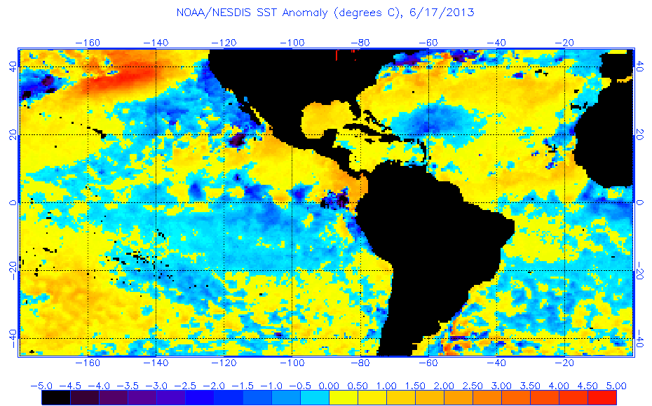
Re: 2013 Steering Pattern / Early indicators
This alone in my view tells me storms will head further westward this season. Tripole look
0 likes
-
cycloneye
- Admin
- Posts: 149472
- Age: 69
- Joined: Thu Oct 10, 2002 10:54 am
- Location: San Juan, Puerto Rico
Re: 2013 Steering Pattern / Early indicators
SFLcane wrote:This alone in my view tells me storms will head further westward this season. Tripole look
http://www.ospo.noaa.gov/data/sst/anoma ... 7.2013.gif
Yes,is established more south which implies what you said.
0 likes
Visit the Caribbean-Central America Weather Thread where you can find at first post web cams,radars
and observations from Caribbean basin members Click Here
and observations from Caribbean basin members Click Here
-
BigB0882
- S2K Supporter
- Posts: 2292
- Joined: Thu Jul 03, 2003 12:08 am
- Location: Baton Rouge, LA
- Contact:
I always find it funny when one set of models changes everyones predictions. It means those models were way wrong before, so what makes them so right to follow them 100% right now? A slow approach is always best. All it takes is one major hurricane to hit a populated area for the season to be memorable, so context is definitely important.
0 likes
Who is online
Users browsing this forum: No registered users and 86 guests