Texas Summer - 2013
Moderator: S2k Moderators
Forum rules

The posts in this forum are NOT official forecast and should not be used as such. They are just the opinion of the poster and may or may not be backed by sound meteorological data. They are NOT endorsed by any professional institution or STORM2K.
-
South Texas Storms

- Professional-Met

- Posts: 4259
- Joined: Thu Jun 24, 2010 12:28 am
- Location: Houston, TX
-
vbhoutex

- Storm2k Executive

- Posts: 29149
- Age: 74
- Joined: Wed Oct 09, 2002 11:31 pm
- Location: Cypress, TX
- Contact:
Re:
Tireman4 wrote:Woo Hoo, although the tropical airmass is not fun.
Says he who is heading to Washington, DC tomorrow.
0 likes
Skywarn, C.E.R.T.
Please click below to donate to STORM2K to help with the expenses of keeping the site going:

Please click below to donate to STORM2K to help with the expenses of keeping the site going:

Tired of summer already? I am! Confidence is growing that this ridge will break down very soon. Not so much from the low that's coming this weekend (West Texas rains) but early next week. Blocking in NW North America will likely cut down the high next week with a sagging front from an unusually strong trough, the deeper the trough the more dramatic the changes. The Euro is showing low to mid 80s for highs and up to 1.5 inches of rainfall in the Red River Valley, DFW included. Bit warmer southern half of Texas with more scattered possibilities.
Meanwhile San Antonio's stretch of rainfall continues another consecutive day! Soon we'll need to get South Texas Storms to ship some for the rest of us

Meanwhile San Antonio's stretch of rainfall continues another consecutive day! Soon we'll need to get South Texas Storms to ship some for the rest of us
0 likes
The above post and any post by Ntxw is NOT an official forecast and should not be used as such. It is just the opinion of the poster and may or may not be backed by sound meteorological data. It is NOT endorsed by any professional institution including Storm2k. For official information, please refer to NWS products.
Help support Storm2K!
-
Portastorm

- Storm2k Moderator

- Posts: 9955
- Age: 63
- Joined: Fri Jul 11, 2003 9:16 am
- Location: Round Rock, TX
- Contact:
Re: Texas Summer - 2013
Yeah, we can see it and smell it here in Austin ... but still the rain is too far south to fall on us. 
Don't get me wrong ... I'm happy for South Texas Storms and the Valley folks. But this ULL is doing nothing for me but providing drenching humidity and no rain. Who knows, if the Summer High Pressure Ridge of Death keeps us on the southern periphery, perhaps the Gulf will be open for business and we'll have a summer full of TUTT lows.
Don't get me wrong ... I'm happy for South Texas Storms and the Valley folks. But this ULL is doing nothing for me but providing drenching humidity and no rain. Who knows, if the Summer High Pressure Ridge of Death keeps us on the southern periphery, perhaps the Gulf will be open for business and we'll have a summer full of TUTT lows.
0 likes
Any forecasts under my name are to be taken with a grain of salt. Get your best forecasts from the National Weather Service and National Hurricane Center.
-
South Texas Storms
- Professional-Met
- Posts: 4259
- Joined: Thu Jun 24, 2010 12:28 am
- Location: Houston, TX
Re: Texas Summer - 2013
Today it poured at my house for the 5th straight day! What a great run I've had here!
It must be really frustrating for you Porta as the cut off line has been around San Marcos for the past few days. Hopefully the cold front that Ntxw is mentioning gives all of Texas some needed rainfall and cooler temperatures next week.
It must be really frustrating for you Porta as the cut off line has been around San Marcos for the past few days. Hopefully the cold front that Ntxw is mentioning gives all of Texas some needed rainfall and cooler temperatures next week.
0 likes
-
vbhoutex
- Storm2k Executive
- Posts: 29149
- Age: 74
- Joined: Wed Oct 09, 2002 11:31 pm
- Location: Cypress, TX
- Contact:
Re: Texas Summer - 2013
South Texas Storms wrote:Today it poured at my house for the 5th straight day! What a great run I've had here.
Not to be rude and nasty from Houston, but
0 likes
Skywarn, C.E.R.T.
Please click below to donate to STORM2K to help with the expenses of keeping the site going:
Please click below to donate to STORM2K to help with the expenses of keeping the site going:
-
Rgv20

- S2K Supporter

- Posts: 2466
- Age: 39
- Joined: Wed Jan 05, 2011 5:42 pm
- Location: Edinburg/McAllen Tx
SPECIAL WEATHER STATEMENT
NATIONAL WEATHER SERVICE BROWNSVILLE TX
155 PM CDT FRI JUN 14 2013
TXZ248-252-142300-
ZAPATA-STARR-
INCLUDING THE CITIES OF...ZAPATA...RIO GRANDE CITY...ROMA
155 PM CDT FRI JUN 14 2013
...HEAVY RAINFALL POSSIBLE ACROSS UPPER PORTIONS OF THE RIO GRANDE
VALLEY THIS AFTERNOON INTO THIS EVENING...
AN UPPER LEVEL LOW ACROSS WEST TEXAS THIS AFTERNOON WILL PROVIDE A
CHANCE OF SHOWERS AND THUNDERSTORMS ACROSS THE UPPER PORTIONS OF
THE RIO GRANDE VALLEY THIS AFTERNOON INTO THIS EVENING. SOME OF
THESE THUNDERSTORMS MAY PRODUCE HEAVY RAINFALL AND WITH THE
RAINFALL THAT FELL ACROSS SOUTHERN PORTIONS OF ZAPATA COUNTY AND
WESTERN PORTIONS OF STARR COUNTY LAST NIGHT...THE POTENTIAL FOR
LOCALIZED FLOODING EXISTS. RADAR ESTIMATES THAT 4 TO 6 INCHES OF
RAIN FELL NEAR THE STARR/ZAPATA COUNTY LINE DURING THE LAST 24
HOURS. AS A RESULT...ANY HEAVY RAINFALL THAT DEVELOPS NEAR THIS
AREA COULD PRODUCE LOCALIZED FLASH FLOODING.
RESIDENTS IN SOUTHERN ZAPATA COUNTY AS WELL AS SOUTHWEST STARR
COUNTY...SHOULD MONITOR THE LATEST ADVISORIES AND POSSIBLE
WARNINGS FROM THE NATIONAL WEATHER SERVICE IN BROWNSVILLE
REGARDING THIS POTENTIAL FLOOD THREAT.
$$
CASTILLO
Here at my house I only had a few sprinkles but just to the west of my area they got hammered last evening.
0 likes
The following post is NOT an official forecast and should not be used as such. It is just the opinion of the poster and may or may not be backed by sound meteorological data. It is NOT endorsed by any professional institution including storm2k.org For Official Information please refer to the NHC and NWS products.


Flash Flood Emergency - 9.34 INCHES OF RAIN IN THE PAST 5 HOURS.
BULLETIN - EAS ACTIVATION REQUESTED
FLASH FLOOD WARNING
NATIONAL WEATHER SERVICE AUSTIN/SAN ANTONIO TX
356 AM CDT SAT JUN 15 2013
THE NATIONAL WEATHER SERVICE IN AUSTIN SAN ANTONIO HAS ISSUED A
* FLASH FLOOD WARNING FOR...
MAVERICK COUNTY...
* UNTIL 700 AM CDT.
* AT 352 AM CDT...NATIONAL WEATHER SERVICE METEOROLOGISTS HAVE
DETERMINED THAT RAINFALL ESTIMATES FROM DOPPLER RADAR INDICATE SLOW
MOVING THUNDERSTORMS WITH VERY HEAVY RAINFALL OVER THE ELM CREEK
TO EAGLE PASS TO ROSITA SOUTH AREA. EAGLE PASS HAS RECORDED 9.34
INCHES OF RAIN IN THE PAST 5 HOURS. ADDITIONAL RAINFALL AMOUNTS OF
1 TO 4 INCHES CAN BE EXPECTED IN THE SECO MINES TO EAGLE PASS TO
ROSITA SOUTH AREAS. NUMEROUS STREAMS AND CREEKS ARE RISING HIGHER
INTO FLOOD. THIS ADDITIONAL RAIN WILL AGGRAVATE THE FLOODING. THIS
IS A LIFE THREATENING SITUATION. EVACUATIONS ARE UNDERWAY FOR
THOSE LIVING ALONG OR CLOSE TO MAIN CREEKS. LOCAL OFFICIALS WILL
BE IN THOSE AREAS TO PROVIDE ASSISTANCE.
A FLASH FLOOD EMERGENCY CONTINUES FOR ELM CREEK TO SECO MINES TO
EAGLE PASS TO ROSITA SOUTH.
* RUNOFF FROM THIS EXCESSIVE RAINFALL WILL CAUSE FLASH FLOODING TO
OCCUR. SOME LOCATIONS THAT WILL EXPERIENCE FLOODING INCLUDE...EAGLE
PASS...EL INDIO...NORMANDY...PALOMA...ROSITA NORTH AND ROSITA
SOUTH.
PRECAUTIONARY/PREPAREDNESS ACTIONS...
THIS INCLUDES THE FOLLOWING STREAMS AND DRAINAGES...
PICOSA CREEK...GRANDE, RIO...ELM CREEK...HEDIONDO CREEK...CHUECO
CREEK...CHIMENEAS CREEK...SALADO CREEK...MUSTANG CREEK...CUEVAS
CREEK...SAN AMBROSIA CREEK AND QUEMADO CREEK.
WHEN WATER COVERS THE ROAD...TURN AROUND DON`T DROWN. THE LIFE YOU
SAVE MAY BE YOUR OWN.
0 likes
The following post is NOT an official forecast and should not be used as such. It is just the opinion of the poster and may or may not be backed by sound meteorological data. It is NOT endorsed by any professional institution including storm2k.org For Official Information please refer to the NHC and NWS products.
-
Portastorm
- Storm2k Moderator
- Posts: 9955
- Age: 63
- Joined: Fri Jul 11, 2003 9:16 am
- Location: Round Rock, TX
- Contact:
Re: Texas Summer - 2013
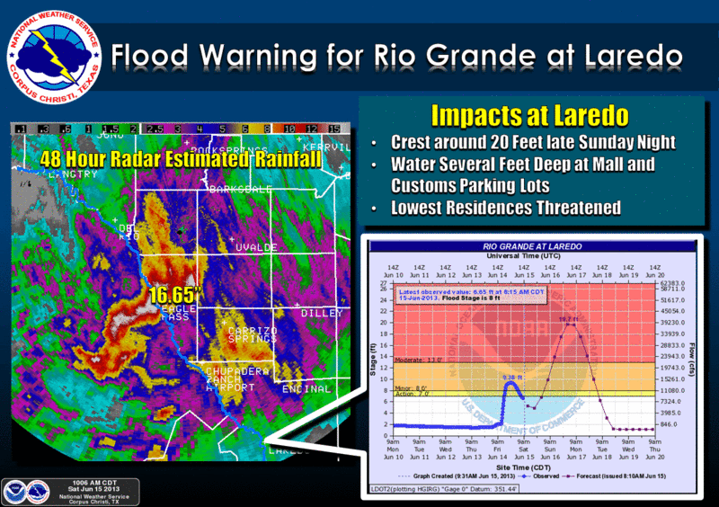
Eagle Pass and Maverick County just got absolutely hammered overnight with nearly a foot of rain. The Eagle Pass mayor is saying 12-15 inches. The nocturnal warm-core rain event has, as you might expect, created havoc with numerous water rescues ongoing. Lots of evacuations as well. Let's hope there is no loss of life.
Amazing what these warm-core events can do.
Amazing what these warm-core events can do.
0 likes
Any forecasts under my name are to be taken with a grain of salt. Get your best forecasts from the National Weather Service and National Hurricane Center.
0 likes
The above post and any post by Ntxw is NOT an official forecast and should not be used as such. It is just the opinion of the poster and may or may not be backed by sound meteorological data. It is NOT endorsed by any professional institution including Storm2k. For official information, please refer to NWS products.
Help support Storm2K!
Help support Storm2K!
-
Rgv20
- S2K Supporter
- Posts: 2466
- Age: 39
- Joined: Wed Jan 05, 2011 5:42 pm
- Location: Edinburg/McAllen Tx
Crazy rainfall totals for sure Porta....will see how much Falcon dam reacts with so much rain upstream.


0 likes
The following post is NOT an official forecast and should not be used as such. It is just the opinion of the poster and may or may not be backed by sound meteorological data. It is NOT endorsed by any professional institution including storm2k.org For Official Information please refer to the NHC and NWS products.
-
Rgv20
- S2K Supporter
- Posts: 2466
- Age: 39
- Joined: Wed Jan 05, 2011 5:42 pm
- Location: Edinburg/McAllen Tx
Brownsville afternoon discussion regarding Rain chances for late next week......If it rains I won't be able to see it as I will be in the Denton area visiting my sister next week! 
.LONG TERM /MONDAY THROUGH SATURDAY/...5H RIDGE CENTERED ACROSS
NORTHERN MEXICO WILL EXTEND INTO TEXAS AND WILL BE IN CONTROL ACROSS
THE RGV AND SOUTH TEXAS MON THROUGH WED. DRY AND HOT WITH VERY
LITTLE HOPE FOR RAIN. EVEN THOUGH THE RIDGE CONTINUES IN CONTROL
WED...MODELS ARE INDICATING THAT A TROPICAL WAVE WILL ENTER THE
BAY OF CAMPECHE. THE DEEP TROPICAL MOISTURE AND ASSOCIATED
RAINFALL WITH THIS SYSTEM IS EXPECTED TO INCREASE IN COVERAGE THU
AND FRI. MODELS HAVE FLIPPED FROM 24 HOURS AGO WITH THE GFS
KEEPING THE SYSTEM FURTHER SOUTH WITH LESS POTENTIAL IMPACT ON THE
RGV...WHILE LAST NIGHTS 00Z EURO BRINGS THE SYSTEM NW AND MAKING
LANDFALL ABOUT 150 MILES SOUTH OF BRO FRIDAY MORNING. IF THIS
SCENARIO PREVAILS...THEN THE POTENTIAL FOR RAIN...PERHAPS
SIGNIFICANT RAIN WILL BE MUCH HIGHER. EVEN THOUGH THE GFS KEEPS
THE SYSTEM FURTHER SOUTH...IT DOES INDICATE THAT A BROAD INVERTED
UPPER TROUGH ACROSS THE WESTERN GULF OF MEXICO WOULD SUBSTANTIALLY
INCREASE ATMOSPHERIC MOISTURE AND INCREASE RAIN CHANCES OVER THE
WEEKEND. FOR NOW...CONFIDENCE IS LOW THAT THE SYSTEM WILL DIRECTLY
IMPACT THE RGV...BUT CERTAINLY BEARS WATCHING. NO MODEL AT THIS
TIME IS INDICATING A WELL ORGANIZED SYSTEM...BUT ONCE AGAIN ALL
SHOULD KEEP A WATCHFUL EYE. AT THE VERY LEAST THERE WILL BE SOME
INCREASE IN THE DEPTH OF THE LOW LEVEL MOISTURE WHICH SHOULD HELP
MODERATE TEMPS A COUPLE OF DEGREES OR SO OFF DAYTIME HIGHS. UNTIL
THEN...WENT CLOSER TO THE WARMER ECMWF NUMBERS FOR DAYTIME HIGHS
DUE TO MUCH DRIER MID LEVELS AND SUBSIDENCE FROM THE MID LEVEL
RIDGE.
0 likes
The following post is NOT an official forecast and should not be used as such. It is just the opinion of the poster and may or may not be backed by sound meteorological data. It is NOT endorsed by any professional institution including storm2k.org For Official Information please refer to the NHC and NWS products.
Wind driven rain from squall this morning over N Texas at rush hour give yourself extra time, roads will be a mess.
0 likes
The above post and any post by Ntxw is NOT an official forecast and should not be used as such. It is just the opinion of the poster and may or may not be backed by sound meteorological data. It is NOT endorsed by any professional institution including Storm2k. For official information, please refer to NWS products.
Help support Storm2K!
Help support Storm2K!
-
Portastorm
- Storm2k Moderator
- Posts: 9955
- Age: 63
- Joined: Fri Jul 11, 2003 9:16 am
- Location: Round Rock, TX
- Contact:
Re: Texas Summer - 2013
MCS's running west to east across North Texas ... ULLs in south Texas with nocturnal warm-core rain events ... temps yet to hit 100 ... yeah, this is the kind of Texas summer I remember. It sure beats the last few!
As I've been discussing with my old friend srainhoutx, this summer is going to be quite different. Any talk about a long-term death ridge over Texas should be tempered by what you're seeing now. Of course, this IS Texas and it IS summer which means we could easily see a week or two period of burn-the-bottom-of-your-bare-feet scorchers. However, I really don't think that is going to be the dominant weather pattern this summer.
As I've been discussing with my old friend srainhoutx, this summer is going to be quite different. Any talk about a long-term death ridge over Texas should be tempered by what you're seeing now. Of course, this IS Texas and it IS summer which means we could easily see a week or two period of burn-the-bottom-of-your-bare-feet scorchers. However, I really don't think that is going to be the dominant weather pattern this summer.
0 likes
Any forecasts under my name are to be taken with a grain of salt. Get your best forecasts from the National Weather Service and National Hurricane Center.
Re: Texas Summer - 2013
Portastorm wrote:As I've been discussing with my old friend srainhoutx, this summer is going to be quite different. Any talk about a long-term death ridge over Texas should be tempered by what you're seeing now. Of course, this IS Texas and it IS summer which means we could easily see a week or two period of burn-the-bottom-of-your-bare-feet scorchers. However, I really don't think that is going to be the dominant weather pattern this summer.
I fully support this train of thought! This is as green a summer around here that I can remember since 2009. The last "death ridge" and the coming one isn't really a death ridge to me, it's just the usual summer high that bumps out from the SW, there's no feedback going on with drought to amplify it. I mean low to mid 90s all week is nothing out of the ordinary in Texas JJA. FW keeps predicting near 100, like again by the end of the week but I just do not see it. Even the euro is backing off to middle 90s which makes sense after this rain. There's been constant S and SE flow from the gulf all over Texas and every other day an MCS or rain hampers the ridge origins in West Texas where the drought really is.
I think we should follow the tropics carefully soon. With the way things are going regarding rain, I bet there is some kind of weakness setting up in Texas this year, I would put odds of seeing a landfall of anything in our state significantly better than the past two season.
0 likes
The above post and any post by Ntxw is NOT an official forecast and should not be used as such. It is just the opinion of the poster and may or may not be backed by sound meteorological data. It is NOT endorsed by any professional institution including Storm2k. For official information, please refer to NWS products.
Help support Storm2K!
Help support Storm2K!

Re: Texas Summer - 2013
Ntxw wrote:Portastorm wrote:As I've been discussing with my old friend srainhoutx, this summer is going to be quite different. Any talk about a long-term death ridge over Texas should be tempered by what you're seeing now. Of course, this IS Texas and it IS summer which means we could easily see a week or two period of burn-the-bottom-of-your-bare-feet scorchers. However, I really don't think that is going to be the dominant weather pattern this summer.
I fully support this train of thought! This is as green a summer around here that I can remember since 2009. The last "death ridge" and the coming one isn't really a death ridge to me, it's just the usual summer high that bumps out from the SW, there's no feedback going on with drought to amplify it. I mean low to mid 90s all week is nothing out of the ordinary in Texas JJA. FW keeps predicting near 100, like again by the end of the week but I just do not see it. Even the euro is backing off to middle 90s which makes sense after this rain. There's been constant S and SE flow from the gulf all over Texas and every other day an MCS or rain hampers the ridge origins in West Texas where the drought really is.
I think we should follow the tropics carefully soon. With the way things are going regarding rain, I bet there is some kind of weakness setting up in Texas this year, I would put odds of seeing a landfall of anything in our state significantly better than the past two season.
Spring 2011 was very dry and warm compared to this past spring. We also had a La Nina winter, unlike this past winter, which was Neutral. West Texas is seeing more rain than in 2011. If West Texas is wetter, less chance to see the cockroach ridge.
0 likes
It looks like scattered showers are trying to pop up in NW and NC Texas. Short guidance thinks they will cluster and another MCS may make a run tonight, tomorrow morning again at DFW. Think they won't make it much further south than Waco so no help for Austin I don't think but they will come close! Maybe the storms in the trans-pecos region will hold together. Houston area is much dependent on sea-breeze and leftover outflows but I'm not confident much will come out of those for now.
All due to weak cold front coming down but will likely stall near I-20

All due to weak cold front coming down but will likely stall near I-20
0 likes
The above post and any post by Ntxw is NOT an official forecast and should not be used as such. It is just the opinion of the poster and may or may not be backed by sound meteorological data. It is NOT endorsed by any professional institution including Storm2k. For official information, please refer to NWS products.
Help support Storm2K!
Help support Storm2K!

-
Portastorm
- Storm2k Moderator
- Posts: 9955
- Age: 63
- Joined: Fri Jul 11, 2003 9:16 am
- Location: Round Rock, TX
- Contact:
Re:
Ntxw wrote:It looks like scattered showers are trying to pop up in NW and NC Texas. Short guidance thinks they will cluster and another MCS may make a run tonight, tomorrow morning again at DFW. Think they won't make it much further south than Waco so no help for Austin I don't think but they will come close! ...
Well the good news for us is that you were wrong Ntxw!
Interesting ... the short-term, high res models blew Monday's forecast for south central Texas but accurately progged this morning's MCS.
Anyhoo ... it's mid June and it is still raining on parts of Texas. Oh, what a beautiful summer already!
0 likes
Any forecasts under my name are to be taken with a grain of salt. Get your best forecasts from the National Weather Service and National Hurricane Center.
0 likes
The above post and any post by Ntxw is NOT an official forecast and should not be used as such. It is just the opinion of the poster and may or may not be backed by sound meteorological data. It is NOT endorsed by any professional institution including Storm2k. For official information, please refer to NWS products.
Help support Storm2K!
Help support Storm2K!
Return to “USA & Caribbean Weather”
Who is online
Users browsing this forum: No registered users and 104 guests