tropical wave near the islands
Moderator: S2k Moderators
Forum rules

The posts in this forum are NOT official forecasts and should not be used as such. They are just the opinion of the poster and may or may not be backed by sound meteorological data. They are NOT endorsed by any professional institution or STORM2K. For official information, please refer to products from the National Hurricane Center and National Weather Service.
-
Hurricaneman

- Category 5

- Posts: 7404
- Age: 45
- Joined: Tue Aug 31, 2004 3:24 pm
- Location: central florida
tropical wave near the islands
Does anyone think this has any chance at development or is shear too strong
0 likes
-
cycloneye

- Admin

- Posts: 149746
- Age: 69
- Joined: Thu Oct 10, 2002 10:54 am
- Location: San Juan, Puerto Rico
Re: tropical wave near the islands
If it has a chance to do something,it has to surpass this big upper trough. (TUTT)

0 likes
Visit the Caribbean-Central America Weather Thread where you can find at first post web cams,radars
and observations from Caribbean basin members Click Here
and observations from Caribbean basin members Click Here

-
floridasun78
- Category 5
- Posts: 3755
- Joined: Sun May 17, 2009 10:16 pm
- Location: miami fl
-
floridasun78
- Category 5
- Posts: 3755
- Joined: Sun May 17, 2009 10:16 pm
- Location: miami fl
Re: tropical wave near the islands
http://www.ssd.noaa.gov/goes/east/carb/vis-l.jpg it look wave getting bigger
it look wave getting bigger
0 likes
-
TropicalAnalystwx13

- Category 5
- Posts: 2109
- Age: 28
- Joined: Tue Jul 19, 2011 8:20 pm
- Location: Wilmington, NC
- Contact:
-
floridasun78
- Category 5
- Posts: 3755
- Joined: Sun May 17, 2009 10:16 pm
- Location: miami fl

Re: tropical wave near the islands
I wouldn't write this wave off just yet, it's under a strong upper low right now so it's not looking like much but in a day or 2 coniditions should become a little more favorable it has a pretty sharp wave axis.
Just a little something to watch for. I don't guess the models are predicting anything cuss it's not getting much fanfare.
Just a little something to watch for. I don't guess the models are predicting anything cuss it's not getting much fanfare.
0 likes
The following post is NOT an official forecast and should not be used as such. It is just the opinion of the poster and may or may not be backed by sound meteorological data. It is NOT endorsed by any professional institution including storm2k.org For Official Information please refer to the NHC and NWS products.
-
SouthFloridawx

- S2K Supporter

- Posts: 8346
- Age: 47
- Joined: Tue Jul 26, 2005 1:16 am
- Location: Sarasota, FL
- Contact:
Re: tropical wave near the islands
I'm wondering if it's possible that it may have some interaction with that stalled cold front in the SE US.

0 likes
-
SouthFloridawx
- S2K Supporter
- Posts: 8346
- Age: 47
- Joined: Tue Jul 26, 2005 1:16 am
- Location: Sarasota, FL
- Contact:
Re: tropical wave near the islands
Looking at GFS it appears as though that UL feature will persist in the same area, eventually moving out to the North.
http://mag.ncep.noaa.gov/list_files_area.php?model=gfs&cycle=12&area=wnatl¶m=200_wnd_ht
http://mag.ncep.noaa.gov/list_files_area.php?model=gfs&cycle=12&area=wnatl¶m=200_wnd_ht
0 likes
-
ScottNAtlanta

- Category 5
- Posts: 2535
- Joined: Sat May 25, 2013 3:11 pm
- Location: Atlanta, GA
Re: tropical wave near the islands
Looking at the watervapor loop...looks like it is lifting out now. Also the area is showing vorticity down to H850. Convergence is low though
0 likes
The posts in this forum are NOT official forecast and should not be used as such. They are just the opinion of the poster and may or may not be backed by sound meteorological data. They are NOT endorsed by any professional institution or storm2k.org. For official information, please refer to the NHC and NWS products.
-
Hurricaneman
- Category 5
- Posts: 7404
- Age: 45
- Joined: Tue Aug 31, 2004 3:24 pm
- Location: central florida
Re: tropical wave near the islands
This should bring heavy rain on Saturday to Florida and Cuba so local flooding with some thunderstorms is possible
0 likes
-
ozonepete
- Professional-Met

- Posts: 4743
- Joined: Mon Sep 07, 2009 3:23 pm
- Location: From Ozone Park, NYC / Now in Brooklyn, NY
Re: tropical wave near the islands
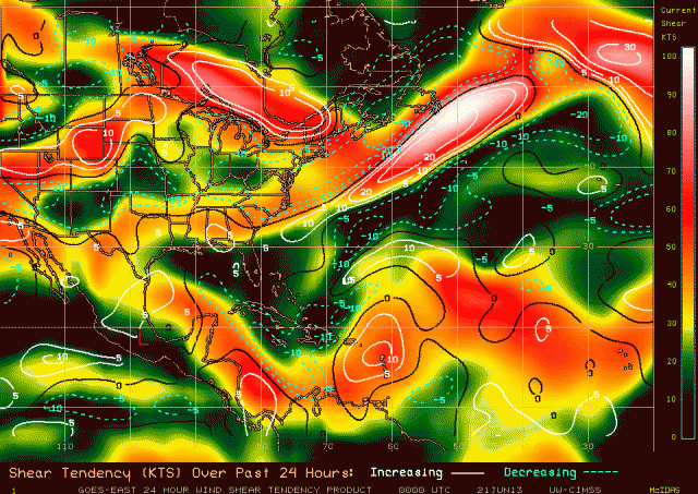
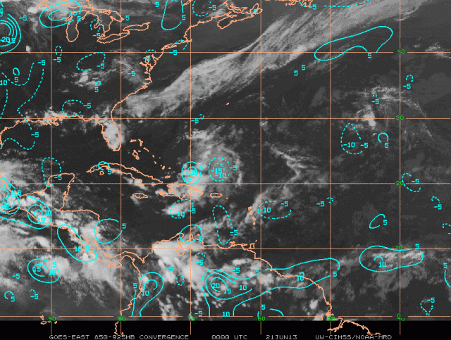
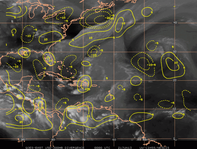
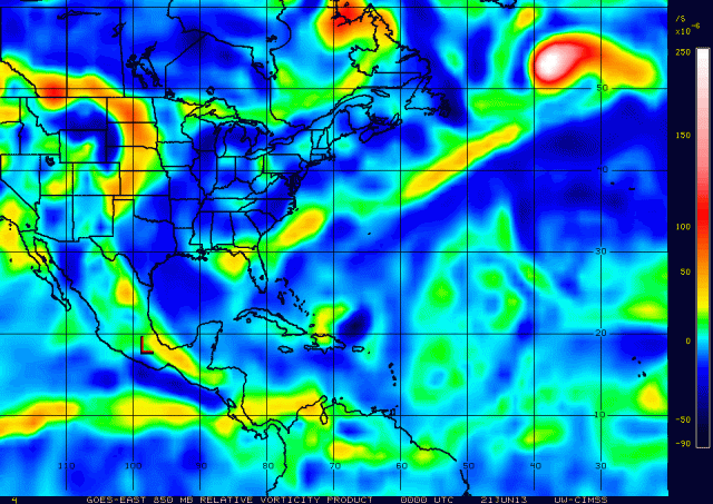
This disturbance has sure had staying power since it started firing up some convection under monster shear earlier in the week. I have been impressed by its persistence and now am impressed by how conditions are changing to much more in its favor. Shear has dropped off significantly in the entire area over it and ahead of it. We can see convection firing up now because of the shear drop. Good upper divergence is getting stacked now over the lower level convergence area, and finally you can see it is associated with a vorticity center that goes from 850 mb all the way up to 500 mb (I'm showing 850 mb, 700mb and 500mb vorticity here.)
I didn't show the mid-level water vapor but there is very little dry air involved at all. the environment is actually quite moist. I think this must be getting attention from the NHC and wonder if conditions will remain favorable - looks like they will.
RGB Satellite:

Shear and Shear Tendency:
Lower level convergence:
Upper divergence:
Vorticity at 850, 700 and 500 mb:


I didn't show the mid-level water vapor but there is very little dry air involved at all. the environment is actually quite moist. I think this must be getting attention from the NHC and wonder if conditions will remain favorable - looks like they will.
RGB Satellite:

Shear and Shear Tendency:

Lower level convergence:

Upper divergence:

Vorticity at 850, 700 and 500 mb:


0 likes
-
ozonepete
- Professional-Met
- Posts: 4743
- Joined: Mon Sep 07, 2009 3:23 pm
- Location: From Ozone Park, NYC / Now in Brooklyn, NY
Re: tropical wave near the islands
Just to finish this off, notice you can roughly see the wave axis by noting the curve in vorticity at 850 and 700 mb. What would help a wave like this to start rotating is if more convection fires up, especially ahead of the wave axis. Looks like that may be starting to happen. If enough convection fires up over and ahead of the wave the tendency for stronger rotation should begin.
0 likes
-
northjaxpro

- S2K Supporter
- Posts: 8900
- Joined: Mon Sep 27, 2010 11:21 am
- Location: Jacksonville, FL
I agree with you ozonepete. If convection can start to fire up , this system may be something to monitor in the coming days. Shear is definitely dropping off, compared to yesterday. Should convection increase in the next 24 hours and sustain itself, we may have a potential of a possible invest coming this weekend as this wave moves westward.
0 likes
NEVER, EVER SAY NEVER in the tropics and weather in general, and most importantly, with life itself!!
________________________________________________________________________________________
Fay 2008 Beryl 2012 Debby 2012 Colin 2016 Hermine 2016 Julia 2016 Matthew 2016 Irma 2017 Dorian 2019
________________________________________________________________________________________
Fay 2008 Beryl 2012 Debby 2012 Colin 2016 Hermine 2016 Julia 2016 Matthew 2016 Irma 2017 Dorian 2019
-
ozonepete
- Professional-Met
- Posts: 4743
- Joined: Mon Sep 07, 2009 3:23 pm
- Location: From Ozone Park, NYC / Now in Brooklyn, NY
Re: tropical wave near the islands
Convection still increasing. If this trend continues it should get the invest and code yellow from the NHC tomorrow I would think.


0 likes
-
floridasun78
- Category 5
- Posts: 3755
- Joined: Sun May 17, 2009 10:16 pm
- Location: miami fl
Re: tropical wave near the islands
ozonepete wrote:Convection still increasing. If this trend continues it should get the invest and code yellow from the NHC tomorrow I would think.
you think still we may need watch it next few days?
0 likes
-
floridasun78
- Category 5
- Posts: 3755
- Joined: Sun May 17, 2009 10:16 pm
- Location: miami fl
-
Aric Dunn
- Category 5
- Posts: 21238
- Age: 43
- Joined: Sun Sep 19, 2004 9:58 pm
- Location: Ready for the Chase.
- Contact:
Re: tropical wave near the islands
ozonepete wrote:Convection still increasing. If this trend continues it should get the invest and code yellow from the NHC tomorrow I would think.
[img]http://i189.photobucket.com/albums/z174/philnyc_2007/satrgb2013-06-210245_zps8125e8ec.jpg[/mg]
Looking at the progression ... it may end up interacting with a developing low off the se coast of the US. notice this morning there is clearly a elongated are of low pressure there and the wave is quickly approaching. I think there might be a brief possibility the next couple days.
http://www.ssd.noaa.gov/goes/east/tatl/loop-rgb.html
0 likes
Note: If I make a post that is brief. Please refer back to previous posts for the analysis or reasoning. I do not re-write/qoute what my initial post said each time.
If there is nothing before... then just ask
Space & Atmospheric Physicist, Embry-Riddle Aeronautical University,
I believe the sky is falling...
If there is nothing before... then just ask
Space & Atmospheric Physicist, Embry-Riddle Aeronautical University,
I believe the sky is falling...
Who is online
Users browsing this forum: No registered users and 274 guests