Global model runs discussion

Moderator: S2k Moderators

Message
Author
User avatar
Bocadude85
Category 5
Category 5
Posts: 2991
Age: 38
Joined: Mon Apr 18, 2005 2:20 pm
Location: Honolulu,Hi

Re: Global Model Runs Discussion

#4681 Postby Bocadude85 » Wed Jun 19, 2013 2:15 pm

SFLcane wrote:
Hurricaneman wrote:
sunnyday wrote:Joe B's mention of a hurricane passing "between Miami and Orlando" means that it passes to the east out to sea or on land between the 2 cities? Thank you for clarifying this for me. 8-) 8-)

Landfall in Palm Beach, will change a whole lot from not existing to major landfall so these ranges are just fantasy


fantasy is right BUT could very well be showing the overall steering pattern this season which is to drive storms further westward.


Just a interesting observation, 1926 and 1928 both featured a tropical cyclone effecting South Florida in July or early August and in both years a major hurricane struck South Florida in September. So if this phantom storm does come to fruition then South Florida could be in trouble during September.
0 likes   

catskillfire51
S2K Supporter
S2K Supporter
Posts: 480
Age: 38
Joined: Sun Aug 26, 2012 5:40 pm
Location: Lake Jackson, TX

Re: Global Model Runs Discussion

#4682 Postby catskillfire51 » Wed Jun 19, 2013 2:48 pm

lookin at the gfs it looks like barry might cross mexico and form in the pacific. Not sure if it will pan out that way but if it does, when was the last time 2 storms crossed, first storm being andrea from pacific to gulf, and now barry possibly going gulf to pacific??
0 likes   

User avatar
cycloneye
Admin
Admin
Posts: 145333
Age: 68
Joined: Thu Oct 10, 2002 10:54 am
Location: San Juan, Puerto Rico

Re: Global Model Runs Discussion

#4683 Postby cycloneye » Wed Jun 19, 2013 2:52 pm

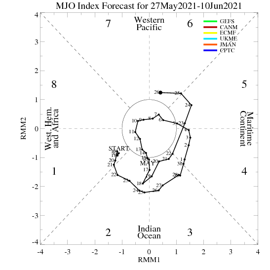
The models should start to show things that try to develop by early to mid July as the strong MJO pulse arrives to octanes 1-8 and this could activate the North Atlantic basin. EPAC for sure will get 1-2 systems.

Image
0 likes   
Visit the Caribbean-Central America Weather Thread where you can find at first post web cams,radars
and observations from Caribbean basin members Click Here

Frank2
Category 5
Category 5
Posts: 4061
Joined: Mon Jul 25, 2005 12:47 pm

Re: Global Model Runs Discussion

#4684 Postby Frank2 » Wed Jun 19, 2013 3:09 pm

It didn't take long for the A/B systems to form, so not an encouraging start that's for sure...

We'll see how long the subtropical ridge holds in it's present position - in past seasons it's relocated or been divided in two, and that's made all the difference on where CV systems will go...

Frank
0 likes   

TheStormExpert

Re: Global Model Runs Discussion

#4685 Postby TheStormExpert » Wed Jun 19, 2013 5:45 pm

Just a interesting observation, 1926 and 1928 both featured a tropical cyclone effecting South Florida in July or early August and in both years a major hurricane struck South Florida in September. So if this phantom storm does come to fruition then South Florida could be in trouble during September.
IMO, I think Florida especially S. Florida is the big target for a major landfall sometime within the next 1-2 years. There's a higher than average chance it will happen this season. If not, next year could have a more average chance with a possible El Niño.
0 likes   

supercane4867
Category 5
Category 5
Posts: 4966
Joined: Wed Nov 14, 2012 10:43 am

Re: Global Model Runs Discussion

#4686 Postby supercane4867 » Wed Jun 19, 2013 6:57 pm

seems fun

Image
0 likes   

User avatar
cycloneye
Admin
Admin
Posts: 145333
Age: 68
Joined: Thu Oct 10, 2002 10:54 am
Location: San Juan, Puerto Rico

Re: Global Model Runs Discussion

#4687 Postby cycloneye » Wed Jun 19, 2013 7:04 pm

:uarrow: It would be very interesting to watch a fujiwara take place.
0 likes   
Visit the Caribbean-Central America Weather Thread where you can find at first post web cams,radars
and observations from Caribbean basin members Click Here

User avatar
sunnyday
Category 5
Category 5
Posts: 1590
Joined: Thu Sep 04, 2003 8:16 pm

Re: Global Model Runs Discussion

#4688 Postby sunnyday » Thu Jun 20, 2013 7:07 am

Is there any more about the before mentioned "landfalling hurricane between Miami and Orlando" around July 12? Is there a link that I can follow other than the Joe Bastardi one that requires payment?
Thank you.... 8-) 8-)
0 likes   

User avatar
N2FSU
S2K Supporter
S2K Supporter
Posts: 1062
Joined: Thu Sep 04, 2003 2:04 pm
Location: Tallahassee, FL

Re: Global Model Runs Discussion

#4689 Postby N2FSU » Thu Jun 20, 2013 8:24 am

06Z GFS a 216hrs; first hint of development in SW Caribbean

Image
0 likes   

User avatar
N2FSU
S2K Supporter
S2K Supporter
Posts: 1062
Joined: Thu Sep 04, 2003 2:04 pm
Location: Tallahassee, FL

Re: Global Model Runs Discussion

#4690 Postby N2FSU » Thu Jun 20, 2013 8:27 am

06Z GFS; 240hrs

Image
0 likes   

User avatar
N2FSU
S2K Supporter
S2K Supporter
Posts: 1062
Joined: Thu Sep 04, 2003 2:04 pm
Location: Tallahassee, FL

Re: Global Model Runs Discussion

#4691 Postby N2FSU » Thu Jun 20, 2013 8:28 am

06Z GFS; 276hrs; BOC storm

Image
0 likes   

User avatar
wxman57
Moderator-Pro Met
Moderator-Pro Met
Posts: 22979
Age: 67
Joined: Sat Jun 21, 2003 8:06 pm
Location: Houston, TX (southwest)

Re: Global Model Runs Discussion

#4692 Postby wxman57 » Thu Jun 20, 2013 8:50 am

catskillfire51 wrote:lookin at the gfs it looks like barry might cross mexico and form in the pacific. Not sure if it will pan out that way but if it does, when was the last time 2 storms crossed, first storm being andrea from pacific to gulf, and now barry possibly going gulf to pacific??


Andrea didn't form from the Pacific storm, though some of that storm's moisture probably made it into Andrea. If Andrea had formed from the Pacific storm then it would have taken the Pacific storm's name. Barry's low-level circulation won't survive the high mountains in its path, though some of its moisture will make it into the East Pac.
0 likes   

User avatar
tropicwatch
Category 5
Category 5
Posts: 3385
Age: 61
Joined: Sat Jun 02, 2007 10:01 am
Location: Panama City Florida
Contact:

Re: Global Model Runs Discussion

#4693 Postby tropicwatch » Thu Jun 20, 2013 9:47 am

N2FSU wrote:06Z GFS; 276hrs; BOC storm
https://imageshack.com/scaled/large/407/utx.gif


The GFS has been pretty good so far this year in longer range forecasts. Probably something to watch during the next week.
0 likes   
Tropicwatch


Agnes 72', Eloise 75, Elena 85', Kate 85', Charley 86', Florence 88', Beryl 94', Dean 95', Erin 95', Opal 95', Earl 98', Georges 98', Ivan 2004', Arlene 2005', Dennis 2005', Ida 2009' Debby 2012' Irma 2017' Michael 2018'

RL3AO
Moderator-Pro Met
Moderator-Pro Met
Posts: 16308
Joined: Thu Jun 14, 2007 10:03 pm
Location: NC

#4694 Postby RL3AO » Thu Jun 20, 2013 10:26 am

MJO looks very favorable coming up in the next few weeks.
0 likes   

User avatar
cycloneye
Admin
Admin
Posts: 145333
Age: 68
Joined: Thu Oct 10, 2002 10:54 am
Location: San Juan, Puerto Rico

Re:

#4695 Postby cycloneye » Thu Jun 20, 2013 10:44 am

RL3AO wrote:MJO looks very favorable coming up in the next few weeks.


Here is the latest forecast by the models including yes the ECMWF that have the strong MJO pulse coming to octanes 1-8.

Image
0 likes   
Visit the Caribbean-Central America Weather Thread where you can find at first post web cams,radars
and observations from Caribbean basin members Click Here

User avatar
wxman57
Moderator-Pro Met
Moderator-Pro Met
Posts: 22979
Age: 67
Joined: Sat Jun 21, 2003 8:06 pm
Location: Houston, TX (southwest)

Re: Global Model Runs Discussion

#4696 Postby wxman57 » Thu Jun 20, 2013 10:45 am

Keep in mind that studies like Maloney & Hartman (2000) have shown that there is typically a spike in Caribbean and Gulf of Mexico TC development about 15 days after the MJO reaches the East Pacific. So if an MJO is reaching the East Pac in early July, we should expect any resulting Atlantic Basin development to occur around mid July.
0 likes   

User avatar
Ntxw
Storm2k Moderator
Storm2k Moderator
Posts: 22785
Joined: Wed Oct 21, 2009 6:34 pm
Location: DFW, Texas

Re: Global Model Runs Discussion

#4697 Postby Ntxw » Thu Jun 20, 2013 11:03 am

wxman57 wrote:Keep in mind that studies like Maloney & Hartman (2000) have shown that there is typically a spike in Caribbean and Gulf of Mexico TC development about 15 days after the MJO reaches the East Pacific. So if an MJO is reaching the East Pac in early July, we should expect any resulting Atlantic Basin development to occur around mid July.


This is assuming it survives to octants 1-2 which is highly favorable. It could very well die off, longer range guidance is not very good in the summer months with the MJO since it moves much slower than in winter. If the AAM rises more then we have a better shot, if not the wave will likely end up weaker.

The EPAC is very good though, it has not only the MJO but a coinciding oceanic Kelvin wave coupled too.
0 likes   
The above post and any post by Ntxw is NOT an official forecast and should not be used as such. It is just the opinion of the poster and may or may not be backed by sound meteorological data. It is NOT endorsed by any professional institution including Storm2k. For official information, please refer to NWS products.

  Help support Storm2K!
Help Support Storm2K

supercane4867
Category 5
Category 5
Posts: 4966
Joined: Wed Nov 14, 2012 10:43 am

Re: Global Model Runs Discussion

#4698 Postby supercane4867 » Thu Jun 20, 2013 11:51 am

12z GFS
Image
0 likes   

caneseddy
Category 5
Category 5
Posts: 1172
Joined: Fri Sep 03, 2004 9:31 pm
Location: Plantation, FL

Re: Global Model Runs Discussion

#4699 Postby caneseddy » Thu Jun 20, 2013 12:23 pm


Interesting that the 12zGFS shows that...it almost looks like an identical path that Hurricane Cindy took in 2005, which made landfall in Louisiana on July 5.

If, and that's a big IF, this confirms, then this season has been an almost exact duplicate of 2005

Let's recap: Andrea formed in the Gulf and made landfall in the Big Bend, even though Arlene of 2005 was in the Panhandle. Barry was a minimal TS in the BOC, just like Bret of 2005 following an almost identical track. Eerily similar to 2005. :double:
0 likes   

User avatar
ScottNAtlanta
Category 5
Category 5
Posts: 2367
Joined: Sat May 25, 2013 3:11 pm
Location: Atlanta, GA

Re: Global Model Runs Discussion

#4700 Postby ScottNAtlanta » Thu Jun 20, 2013 1:27 pm

caneseddy wrote:


Interesting that the 12zGFS shows that...it almost looks like an identical path that Hurricane Cindy took in 2005, which made landfall in Louisiana on July 5.

If, and that's a big IF, this confirms, then this season has been an almost exact duplicate of 2005

Let's recap: Andrea formed in the Gulf and made landfall in the Big Bend, even though Arlene of 2005 was in the Panhandle. Barry was a minimal TS in the BOC, just like Bret of 2005 following an almost identical track. Eerily similar to 2005. :double:


Funny too that the MJO pulse would be right about the same time as Dennis and Emily...(cue music from movie Halloween...) ;-)
0 likes   
The posts in this forum are NOT official forecast and should not be used as such. They are just the opinion of the poster and may or may not be backed by sound meteorological data. They are NOT endorsed by any professional institution or storm2k.org. For official information, please refer to the NHC and NWS products.


Return to “2015”

Who is online

Users browsing this forum: No registered users and 9 guests